Net of Natural
Trails

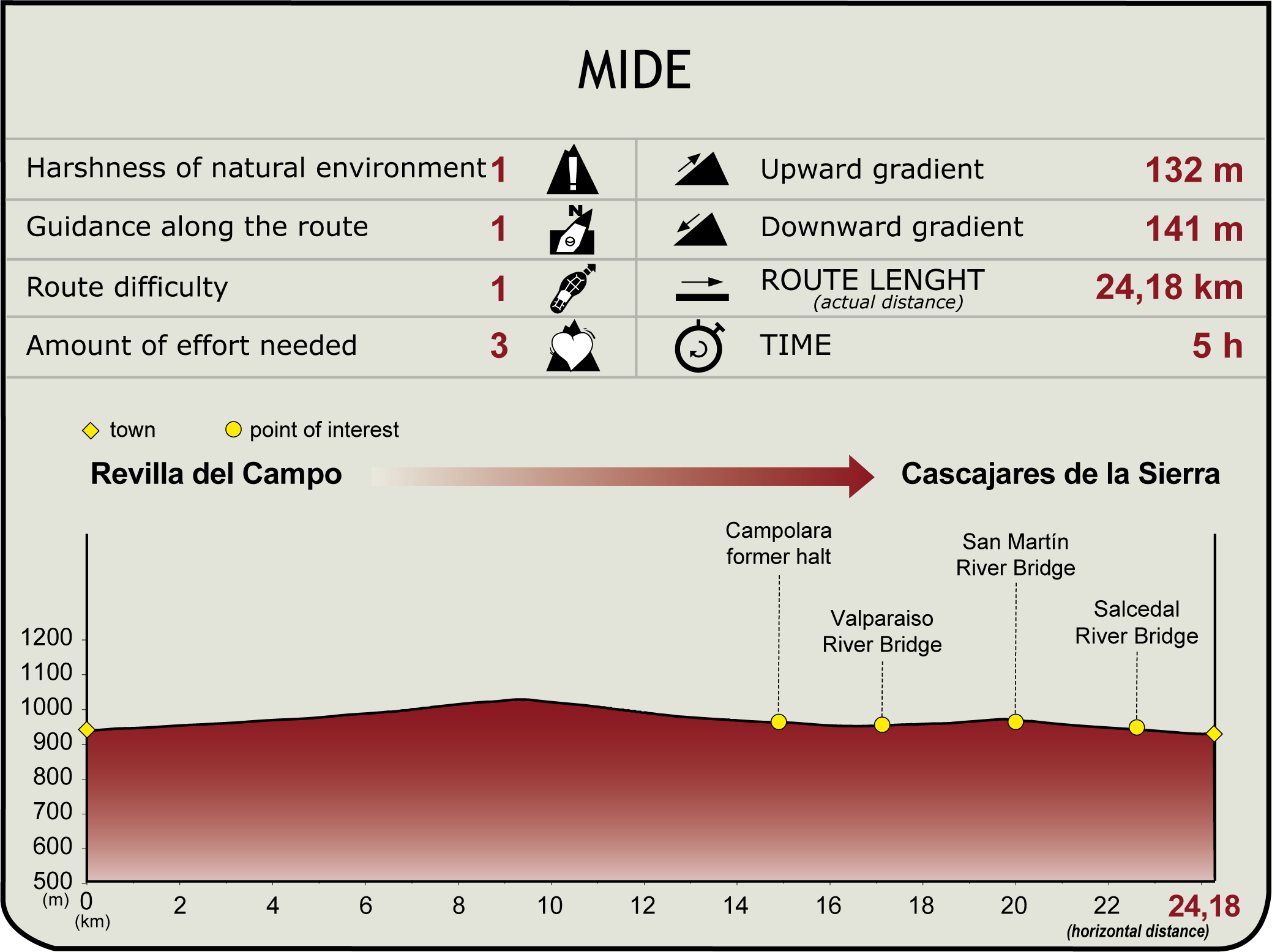
Stage: Revilla del Campo - Cascajares de la Sierra
Description
Peñalara: a silent witness to the comings and goings of the Santander-Mediterranean railway.
In the picturesque village of Revilla del Campo, located a few kilometres south of the capital of Burgos, we begin this section of a Nature Trail steeped in history and prehistory. A number of dinosaur remains have been found here and, according to the medieval epic poem, the Cantar de Mio Cid this route also witnessed the exile of the knight Rodrigo Díaz de Vivar, El Cid Campeador.

This stage of just over 24 kilometres starts in the village of Revilla del Campo, next to the Nature Trails interpretative panel, located between the two districts of the locality.
From here, the trail continues in parallel to the BU-P-8012 road, passing through various areas with evergreen oak (Quercus ilex) shrubland and riverside vegetation, white poplars and aspen (Populus) abound due to the humidity provided by the River Lara.
When you reach the road leading to the village of Quintanalara, cross with caution. At the entrance to the town, there is a tribute to the Santander-Mediterranean Railway with several elements of this railway line preserved. A small section of the railway track is displayed with all its elements along with a signpost to which a commemorative plaque has been erected to tell the story the railway. But this is not the only point of interest in this town. There is the parish church and El Potro Exchange Library, located in a restored taína, a traditional livestock hut, with more than 16,000 books.

At a crossroads, a sign offers the chance to visit the charming village of Torrelara, located 1029 metres above sea level. There visitors can find the Church of San Millán, which served as a watchtower in the Middle Ages, thanks to its strategic location. For several kilometres, the Nature Trail has shared shares a route with the Route of El Cid (GR-160), recreating the legendary journey of the medieval knight Rodrigo Díaz de Vivar, as narrated in the epic poem, the Cantar de Mio Cid.
As we advance, the vegetation changes and gall oaks and Pyrenean oaks appear, while on the horizon we catch sight of the Peñalara mountain for the first time, the most important orographic landmark of the stage. Continuing along the route, we leave the small village of Paules de Lara on the right, where fossil remains belonging to the femur of a dinosaur were found. To the left of Peñalara, the remains of the Lara Castle majestically. Built in the 10th century and renovated in the 14th century, this castle played a fundamental role for the Christian troops and, in its heyday, it had six defensive towers and the imposing keep, to which most of the few remains that are preserved today belong.

After carefully crossing the road that leads to Aceña de Lara, a small hamlet whose name comes from Arabic word meaning waterwheel, the trail continues to reveal more treasures. Two kilometres further on, the Church of La Natividad de Nuestra Señora can be seen, located in Lara de los Infantes, an important municipality for the defence of these territories throughout history. Shortly before crossing the road that leads to Campolara, we reach the old Campolara Station. The buildings are faithful witnesses to abandonment and the passage of time, adding an air of nostalgia to the route. After this succession of towns, the Nature Trail continues its route through mostly agricultural land.
After reaching a new kilometre marker, the path crosses the bridge over the Valparaiso River, surrounded by a leafy forest of white poplars (Populus alba). This is the prelude to the village of Villaespasa, where the imposing Church of Santa Eulalia dominates the landscape. Two kilometres further on, for the final part of this stage, we begin a gentle descent that offers our final view of the omnipresent Peñalara when looking back. The route continues across the San Martín River over a bridge, turning to the south. As the route approaches the protected natural area of the Sabinares de Arlanza (SCI and SPAB), the first specimens of juniper (Juniperus thurifera) appear.

Immediately after the crossroad on the road to Cascajares de la Sierra, we cross a bridge over the River Salcedal. This small Burgos village stands out not only for its architectural heritage, the centre piece of which is the Church of La Natividad de Nuestra Señora, but also for its natural surroundings, facing the Sierra del Gayubar mountain range. In the surrounding are we might find griffon vultures (Gyps fulvus) flying around the rocky outcrops.
On the final stages of the route, a dense thicket of Pyrenean Oak (Quercus pyrenaica) accompanies the traveller to the left of the path. The journey concludes at the old Cascajares-Hortigüela siding, equipped with an interpretative panel and Rest Area, offering a perfect end to this stage full of history and natural beauty.
Managing Entities
Sites of Interest
Puntos de interés
Culture
- Ermita de San Juan
- Monasterio de San Pedro de Arlanza
- Castillo de Lara
- Ermita de San Roque
- Ermita visigótica
- Ermita de San Cristóbal
- Ermita de San Olav
Hydrography
Infrastructure
Municipality
- Paúles de Lara
- Lara de los Infantes
- Campolara
- Vega de Lara
- Cascajares de la Sierra
- Aceña de Lara
- Cubillejo de Lara
- Quintanilla de las Viñas
- Villaespasa
- Revilla del Campo
- Quintanalara
- Jaramillo Quemado
- Torrelara
Orography
Vegetation
Profile

(Calculated according to the MIDE criteria for an average excursionist with a light load)
Highlights
Following in the footsteps of El Destierro
The route of the old Santander- Mediterranean railway and Nature Trail intersects with the Route of El Cid at several point. This route follows the footsteps of the medieval knight Rodrigo Díaz de Vivar, as narrated in the anonymous late 12th and early 13th century epic poem, the Cantar de Mio Cid At a time riven by conflict, El Cid Campeador was exiled and forced to leave his family and hometown behind, abandoning the kingdom within 30 days. The route taken was that narrated in the literary work, albeit there are areas that are not well described as such routes have been adapted depending on the means by which they are undertaken.
Multimedia
Downloads
GPS Downloads
Documents
Cyclability
CICLABILITY
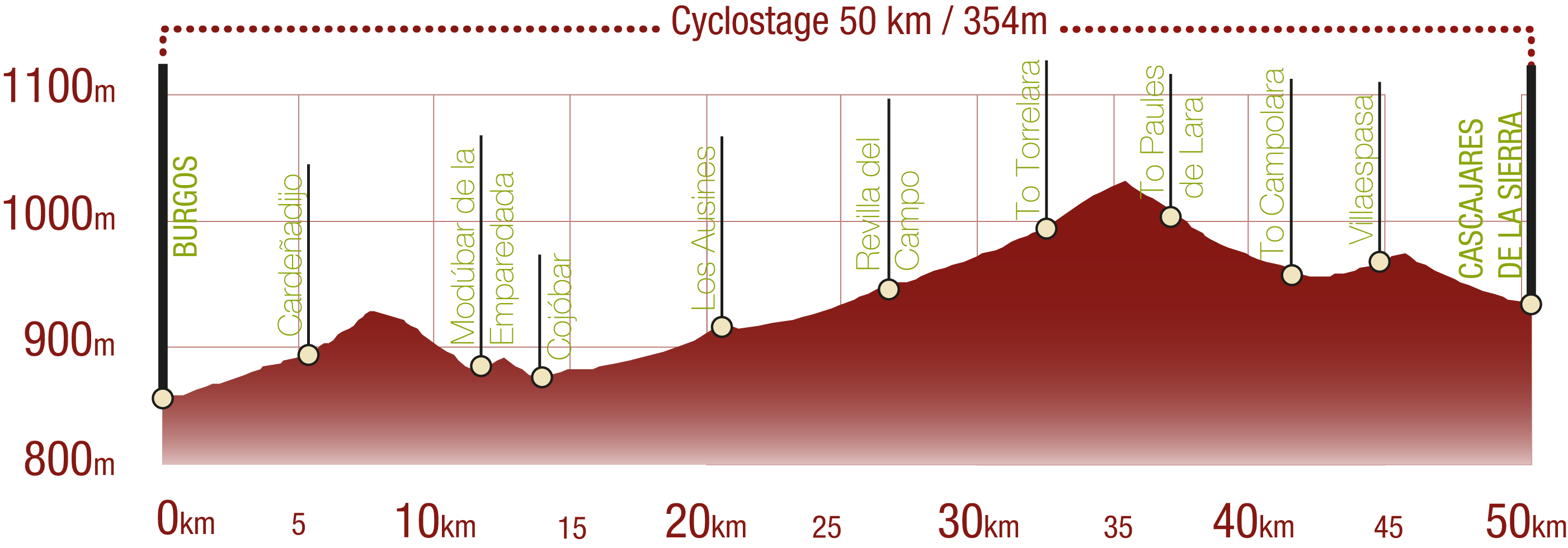
This Cyclostage corresponds to stage Burgos - Revilla del Campo and stage Revilla del Campo - Cascajares de la Sierra of the Nature Trail
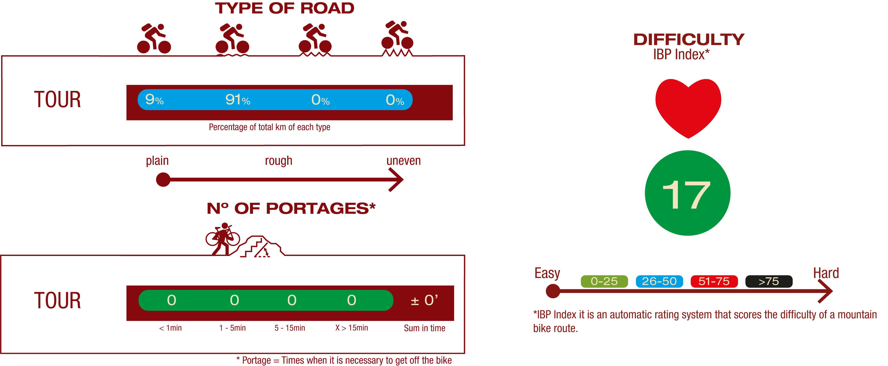
TYPE OF ROADS, PORTAGES & DIFFICULTY
SAFETY RECOMMENDATIONS
Extreme precautions must be taken in the urban section of Burgos. There is a 590 meter long tunnel without artificial lighting and numerous access road crossings to the towns through which the route passes nearby.
GENERAL RECOMMENDATIONS
- Find out about the technical aspects of the route and the weather on the day.
- Take care of the environment. Take care not to disturb animals or damage vegetation. Respect private areas. - You must give priority to pedestrians and comply with general traffic rules.
- The environment in which you will be riding is open, free to move around and an area where many activities are carried out (sporting, forestry, livestock and agricultural activities).
- Always have an understanding, prudent, responsible and respectful attitude.


