Net of Natural
Trails

Stage: Oña - Quintanarruz
Description
Leaving the Montes Obarenes-San Zadornil behind by the River Homino and its tributaries.
A stage of almost 28 kilometres that starts in Oña, a town known for the Monastery of San Salvador, located in the last foothills of the Montes Obarenes-San Zadornil Natural Park. Along this route, we cross the comarca of La Bureba, which offers a great variety of landscapes and environments, such as the picturesque Valle de Las Navas, a chromatic spectacle caused by erosion. A visit to Poza de la Sal, birthplace of the legendary Spanish naturalist Félix Rodríguez de la Fuente, is also a must.
The stage begins at the foot of the monument town of Oña, next to the Caminos Naturales interpretative panel, and the 0 kilometre marker. Both elements are located in the old railway facilities of Oña station, which have now been transformed into rural public accommodation, adapting the warehouse for use as sports facilities.
The route continues, in the first stage, sharing a small stretch with motorised vehicles, providing access to the aforementioned facilities and a parking area for motorhomes. However, hikers and cyclists will soon be able to enjoy this route exclusively.
We leave the town of Oña behind, before visiting the well-known monastery of San Salvador de Oña, where the Cloister of the Knights and the central nave of the Church of San Salvador stand out. You can also enjoy the Church of San Juan Bautista, the Resin Museum and the Medieval Museum.
In the heart of the comarca of La Bureba, the route follows the old railway line and, before reaching the second kilometre of the stage, the small medieval village of Tamayo comes into view. Here, visitors can leave the hustle and bustle behind and stroll through sloping streets and visit the Casa de la Memoria de Tamayo, which is part of the Living Museums Network of Castilla y León, revealing the historical importance of the area.
Back on the path, the route continues flanked by the attractive landscape of the last foothills of the Oña Mountains. A few metres from kilometre 4, there is an old gatekeeper's hut, a sure sign of an imminent crossroads. The passage of time can be appreciated in the state of conservation of this old railway building, located at kilometre 308.093 of the old railway line, according to an inscription on its façade. After passing the kilometre marker, we reach the town of Terminon, dominated by the imposing Church of La Natividad de Nuestra Señora. On the other side of the road, the River Homino flows into the Oña, as its gallery forest accompanies the traveller.
After just over a kilometre, we reach the old Terminón-Castellanos station, located, as its name suggests, between the two towns. Next to the old building, an interpretative panel and a rest area offer the perfect opportunity to take a break, obtain information about the route and the surroundings and take stock of what has been done and what remains to be done.
At the sixth kilometre of the stage, we reach the village of Castellanos de Bureba, where we can visit the Church of La Degollación de San Juan Bautista and taste the region's famous cherries, grown thanks to the area's favourable microclimate. Farmland began to gain prominence, taking advantage of the fertile soils of the fertile plain of the River Homino.
Not far past the nine kilometre marker, we reach a crossing with the exit for the village of Salas de Bureba, and a Rest Area can be found on the other side of the town. Here, visitors can admire the Church of Santa María, built on the site of an earlier Romanesque church, and explore the various manor houses with their elegant and sober construction.
We return to the Nature Trail heading south in parallel with the BU-P-5028 road, staying to the right. To the left, the River Homino flows with its characteristic riparian forests, the whole of its basin being protected as a Site of Community Interest under the name of Riberas del Río Oca and tributaries.
Shortly after passing another kilometre marker, we reach the old Poza de la Sal station, which was equipped with a warehouse during its active railway years and now has a Rest Area as part of the Nature Trail. Continuing along the route, we must cross the CL-633, taking the necessary precautions. At this point, another box on the rail guard once again reminds us of the railway heritage of our route.
Next to a new kilometre marker, on the right of the route we can make out the sanctuary-shelter of Nuestra Señora de Pedrajas, whose original construction was documented as early as 1011. Initially it consisted of a single nave to which, centuries later, the inn that today serves as a municipal hostel.
After another kilometre, the route crosses the BU-V-5103 road, requiring us to take the necessary precautions, and where there is a small Nature Trails lectern panel which invites us to visit the charming village of Poza de la Sal, less than two kilometres from the route.
Its old quarter has been declared a Historic-Artistic Site since 1982, where the Church of San Cosme and San Damián stands out. On the outskirts of the village, but very close to it, are the Reales Salinas, declared a Protected Cultural Heritage site in 2001, and the castle of Los Rojas, offering spectacular views. The village is famous as the birthplace of the legendary Spanish naturalist Félix Rodríguez de la Fuente.
Returning to the trail, the views of the mountain range with the Castle of Rojas and Poza de la Sal on its slopes urge the traveller to cast their gaze back behind them for various kilometres. The route continues along the gentle slopes of an old railway line until we reach the old halt station at Lences de Bureba. Shortly after, we cross the BU-V-5021 road, taking extreme precautions, from where we can already make out the town that gives it its name, with attractions including the Church of Santa Eugenia and a medieval bridge over the River Castil, just before it flows into the River Homino.
Leaving the town behind, the path is lined with cereal crops and ever-present, leading quietly along a remarkable landscape visibly marked by erosion. All this without losing sight of the River Homino. After several kilometres, we reach the Rest Area that before the old Arconada siding, which is in a better state of conservation than others previously visited due to a refurbishment. A few metres further on, to the left of the route, is the village of Arconada, where the Church of Santa Eulalia dominates the landscape. It is the last village in the comarca of La Bureba on this stage.
The route becomes submerged entirely in the Valley of Las Navas, where over the course of a few kilometres we can enjoy a spectrum of colours of the different strata that have been revealed over the long processes of erosion. The beauty and calm breathed in the valley of the encased River Homino cause the walker to experience a pleasurable feeling of isolation and disconnection from the worldly noise.
After carrying this spectacular visual souvenir of the Valle de Las Navas in your backpack, the old railway line makes several bends to the left and right with a broad, characteristic turning radius, arriving a short while later at the village of Lermilla, which is preceded by its rest area of the same name. This small village, which belongs to the Merindad de Río Ubierna, houses the church in honour of San Esteban Protomartir. After crossing the River Homino and the road that leads to Lermilla, you reach the old Lermilla-Quintanarruz siding, today in ruins.
A short distance separates the travellers from the end of the stage, at the Nature Trails interpretative panel at the entrance to the village of Quintanarruz. Make sure not to leave the village without enjoying this small town and its surroundings, without forgetting the Church of Santa Leocadia, dating from the 12th century.
Managing Entities
Links of Interest
Puntos de interés
Culture
- Ermita de Ntra. Sra. de los áüngeles
- Iglesia gótica de La Mota
- Ermita del Ecce Homo
- Castillo de los Rojas
- Santuario Nuestra Señora de Pedrajas
- Salinas Reales
Geology
Hydrography
Infrastructure
- Antigua Estación de Peñahorada
- Antiguo Apeadero de Villaverde Peñahorada
- Antiguo Apartadero de Arconada
- Túnel de la Hoz
- Túnel del Callejón
- Antigua Estación de Poza de la Sal
- Antiguo Apeadero de Lences
- Antiguo Apartadero de Lermilla-Quintanarruz
Municipality
- Cobos Junto a La Molina
- La Molina de Ubierna
- Lences de Bureba
- Lermilla
- Poza de la Sal
- Peñahorada
- Quintanarruz
- Villaverde Peñahorada
- Arconada
- Castellanos de Bureba
- Salas de Bureba
Orography
Hostel
Vegetation
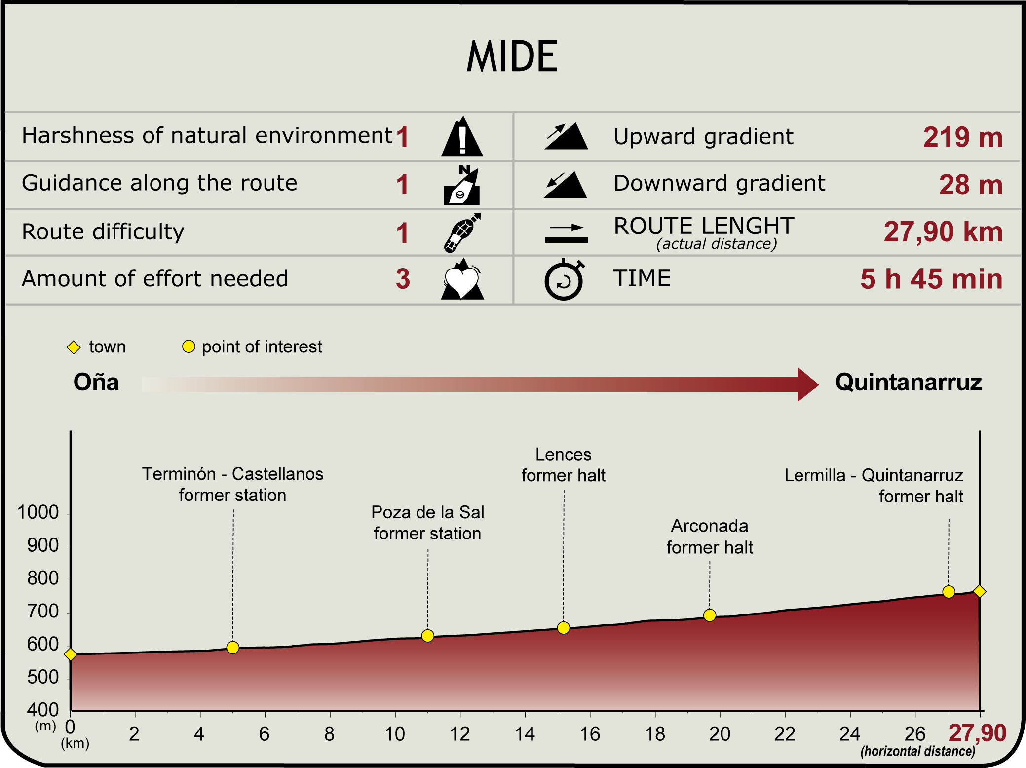
Profile

(Calculated according to the MIDE criteria for an average excursionist with a light load)
Highlights
Félix Rodríguez de la Fuente
Born in Poza de la Sal (Burgos) in 1928, Félix Rodríguez de la Fuente spent his early years in this town. Although he graduated in medicine in Valladolid and in stomatology in Madrid, his innate passion for nature led him to become one of the world's most renowned naturalists and popularisers.
In 1954, he was one of the signatories of the founding act of the Spanish Ornithological Society (SEO). Nine years later he published his first book, Cetrería y Aves de Presa (Falconry and Birds of Prey), and a year later, in 1964, he began a brief fortnightly collaboration on the RTVE programme Fin de Semana, which would last for four years.
After several successful graphic and audiovisual publications, El Hombre y la Tierra (Man and the Earth) was undoubtedly his most famous series. International in scope, it consisted of 124 episodes and was divided into three parts: Iberia, South America and North America.
De La Fuente died on 14 March 1980 in an air crash in Alaska, along with the pilot and two of his camera operators for Man and Earth, but his legacy continues today, promoting respect for the natural environment, instantly recognising the tune created by Antón García Abril.


