Net of Natural
Trails

Stage: Barracas - Caudiel
Description
- - - - - - - -
IMPORTANT NOTICE!
DUE TO THE WORKS BEING CARRIED OUT BY ADIF ON LINE 610 - TERUEL-SAGUNTO JUNCTION, THE NATURAL TRAIL ROUTE IS INTERRUPTED; AN ALTERNATIVE ROUTE HAS BEEN ESTABLISHED AND WILL BE PROPERLY SIGNPOSTED.
IT IS ESTIMATED THAT THIS SITUATION WILL BE RESOLVED IN A FEW MONTHS.
THANK YOU FOR YOUR UNDERSTANDING.
- - - - - - - -
A mountain stage in the Alto Palancia
The beginning of the stage in Barracas and its plains contrast with the mountainous landscape beyond, where pine, holm oak and kermes oak woods populate these mountains, which can be enjoyed from the Mirador del Ragudo viewpoint. The route features a series of tunnels, old stations and rest areas while one of the architecture highlights is La Fuensanta Viaduct with its eight arches.

This stage, over 24 kilometres long, starts in the town of Barracas in Castellón, where it is possible to visit the Church of San Pedro Apóstol and the fountain and Shrine of San Roque. We start our route leaving the town behind us on the left, where a few metres later on the same side we see the Barracas station of the railway line currently in use, which runs parallel to the Nature Trail.
A little further on, at the next kilometre marker, there is a signpost indicating the direction to take if we want to take a detour to visit the village of El Toro, located some 6 kilometres off the route of the Nature Trail. At the same point, a metal signpost shows the distance to different points along the route: Llano rest area, 2.5 km; Torás station area, 8.3 km; and Masadas Blancas, 14.6 km.
The route continues in a straight line in a southerly direction, reaching a new kilometre marker. The route is flanked by a dry-stone snow wall, as indicated by a metal sign, originally built to protect the railway line from bad weather.
After another kilometre, we reach the Llano de Barracas rest area, equipped with tables with benches and bike racks, and a small poplar tree (Populus nigra) that in summer provides much sought after shade.

Barely two kilometres later, the straight line to the south is abandoned and the old railway line is also temporarily abandoned. At this point, a stretch shared with motor traffic begins and although all the necessary signage is in place, caution is required. Shortly afterwards, the route turns to the left, crossing a subway over the railway line currently in use, which as usual runs parallel to that of the old mining railway.
It is time to ascend, following the signs, zigzagging between the wind turbines of the Alto Palancia II Wind Farm, dotted with copses of holm oaks(Quercus ilex) in scrubland. A little over a kilometre later, the route returns to the old mining railway line, bringing the section shared with motor traffic to an end.
At the end of this ascent, the route continues downhill through scrubland and Kermes oak (Quercus coccifera). At the next crossroads, we reach the route of the GR-7, a long-distance footpath this is part of the Senderos de Gran Recorrido network, which heads towards Tarifa, some 2,132 kilometres away, as indicated by a signpost.

After passing another kilometre marker, a new crossroads offers the chance to take a quick 200-metre detour to see the ruins of the Masía de la Cerrada farmhouse. The writer, painter and traveller Antonio Ponz Piquer was born here in 1725. A short while later, the old Torás-Bejís station comes into view, which belongs to the railway line currently in use, and then the old Torás station is reached, included among the infrastructures of the old mining railway line. A rest area has been set up here now to allow visitors to recover their strength and enjoy these two abandoned infrastructures in peace and quiet.
The Aleppo pine forests (Pinus halepensis) alternate with almond trees (Prunus dulcis) along the path to the Ragudo viewpoint, which offers stunning views of the Sierra Espardà Natural Park. From here, an area of trenches dug into the natural rock begins. Stay alert, as an old sign warns of the danger of landslides.
After a new kilometre marker and an excavated drainage gallery with a signpost, we come across a tunnel. This first tunnel is followed by two others. All three are equipped with lighting, although it is recommended to carry a torch all the same.

The Masadas Blancas rest area awaits one kilometre further on. This is an ideal spot for a break surrounded by old railway buildings, before continuing on towards a small viaduct. The single-arch construction crosses a small riverbed and behind it a metal sign tell us it is 8.5 kilometres to the town of Caudiel.
The kilometres pass us by, as we continue parallel to the modern railway, as almond groves start to dominate the landscape rather than the Aleppo pine forests. At a crossroads, wooden signs invite you to visit the town of Viver, which, although technically not the route, is worth a detour to stroll through its streets and enjoy its architecture heritage. That treasure trove includes the Plaza Mayor, the Church of La Virgen de Gracia, built in the 14th century on the site of an earlier mosque, and the Huertos Gate, with robust masonry walls and ashlars dating from 1606.

Back on the trail, we can fully enjoy the surrounding landscape thanks to the easy terrain. After reaching another kilometre marker, La Fuensanta Viaduct comes into view, which, with its 125 metres in length and its 8 arches, passes over the riverbed that flows downstream into the Barranco del Cascajar ravine.
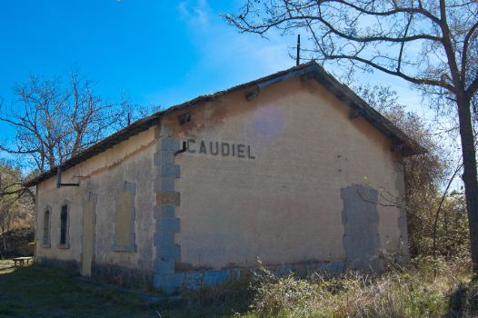
After a gentle curve and a few more kilometres in the legs, we reach the ruins of an old railway building, some of the walls of which are still partially preserved today. In less than a kilometre, we reach the old Caudiel station. The complex consists of a pretty well preserved and walled building, as well as a rest area where we can take a final breather ahead of the final stretch of the stage.
After passing through a tunnel, equipped lighting, the route reaches the town of Caudiel, where this exciting stage of the Santander-Mediterranean Nature Trail comes to an end. A beautiful town in which the Aníbal Tower, the Church of San Juan and the Convent of Las Carmelitas Descalzas stand out.
Managing Entities
Sites of interest
Puntos de interés
Culture
Infrastructure
- Muro Cortanieves
- Parque Eólico Alto Palancia II
- Túnel
- Túnel
- Viaducto de La Fuensanta
- Antigua Estación de Barracas
- Túnel
- Antigua Estación de Caudiel
- Antigua Estación de Torás
- Túnel
Municipality
Vegetation
Passport
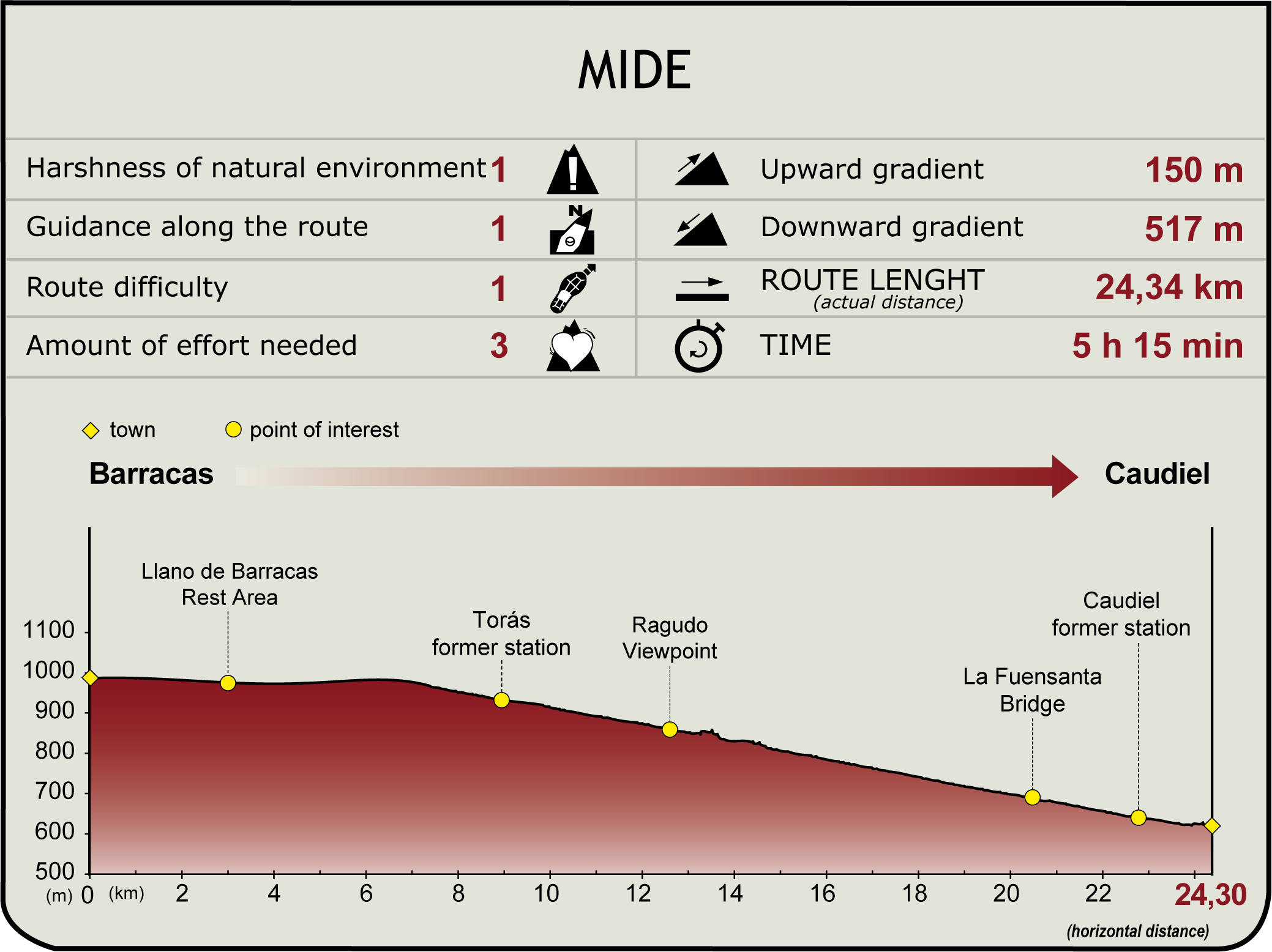
Profile

(Calculated according to the MIDE criteria for an average excursionist with a light load)
Highlights
Caudiel Caudiel is a municipality and town located in the province of Castellón in the comarca of Alto Palancia. Although remains dating back to Iberian and Roman times have been found in the vicinity, it was not until the Moorish period that the municipality began to look like it does today. In 1236 King James I the Conqueror reconquered the town, which became part of the Lordship of Jérica until the death of Pere IV. Subsequently, thanks to Juan Alonso de Jérica, through his Town Charter, the municipality was brought under the ruling jurisdiction of the fueros of Aragon in 1367. In 1538, the municipality belonged to the Duke of Calabria and, after his death, it was handed to the Monastery of San Miguel.
The town is home to a number of buildings and constructions of great interest. El Molino Tower or Aníbal Tower, an ancient defence tower of origin unknown was used by the Moors to attack the Roman city of Sagunto. Its religious heritage includes the Church of San Juan Bautista, which in the past was an Augistinian Convent, founded in 1616. Also worth a visit are the 17th century Convent of Las Carmelitas Descalzas, and the 15th century Shrine of El Socos with its rectangular ground plan and wooden roof.
The natural value of the Alto de Palomas route is another of Caudiel's attractions. This route crosses a landscape dominated by junipers and holm oaks that reaches a trigonometrical station at an altitude of 1150 metres.
As well as the patron saint festivities, the town also celebrates the feasts of Santa Úrsula and San Antonio stand out. During these celebrations, bonfires are lit and a torrá de embutidos is organised. The Cherry Festival, started in 1998, is another highlight. It sees young people dressed in traditional costumes present visitors with bunches of cherries. The aim is to highlight the importance of this fruit in local culture and as a tourist attraction.
Multimedia
Downloads
GPS Downloads
Documents
Cyclability
CICLABILIDAD
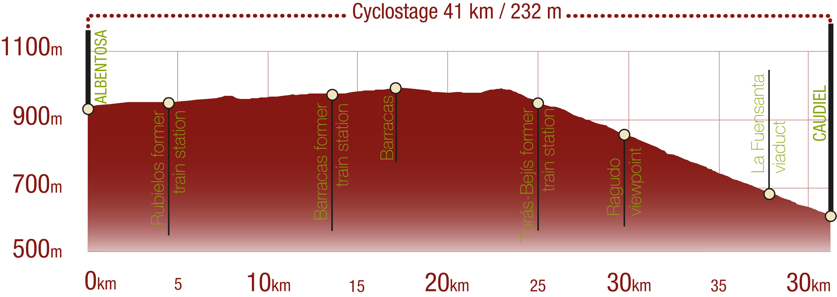
This Cyclostage corresponds to stage Albentosa - Barracas and stage Barracas - Caudiel Burgos of the Nature Trail
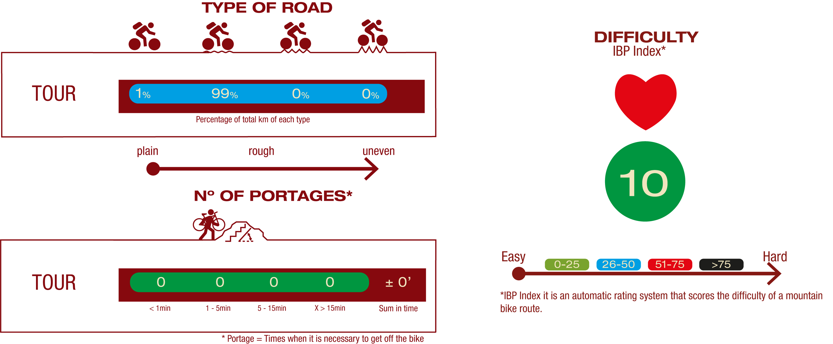
TYPE OF ROADS, PORTAGES & DIFFICULTY
SAFETY RECOMMENDATIONS
There are seven tunnels, six of them equipped with artificial lighting, several road crossings, a small shared section and two road crossings, ending the stage in the streets of Caudiel.
GENERAL RECOMMENDATIONS
- Find out about the technical aspects of the route and the weather on the day.
- Take care of the environment. Take care not to disturb animals or damage vegetation. Respect private areas.
- You must give priority to pedestrians and comply with general traffic rules.
- The environment in which you will be riding is open, free to move around and an area where many activities are carried out (sporting, forestry, livestock and agricultural activities).
- Always have an understanding, prudent, responsible and respectful attitude.


