

Net of Nature
Trails

Stage: Teruel - Puebla de Valverde
Description
Ascending to Puerto de Escandón through pine and juniper forests
A high altitude stage, which starts in monumental city of Teruel at the iconic mining railway station. From there the route climbs through laricio pine forests (Pinus nigra) through the Hoya de Teruel, to then cross the Sabinares del Puerto de Escandón (SCI), to the top of the pass. The route then descends gently towards the Mediterranean Sea begins, and this stage ends at the old station of La Puebla de Valverde.

Our starting point for this stage is at the old Teruel station, right next to the Caminos Naturales interpretative panel. This station complex included a number of different buildings, including the station itself, on the left of the route, and the depot, on the right.
However, before embarking on this exciting journey, everyone should explore and enjoy the monumental city of Teruel. Teruel has been inhabited from time immemorial, thanks to its strategic location between the Rivers Guadalaviar and Alfambra, which merge to form the River Turia. In November 1986, UNESCO declared the city of Teruel a World Heritage Site for its impressive ensemble of Mudéjar architecture, including the Cathedral of Santa María de Mediavilla, the Tower of San Martín and the Tower of El Salvador which will make a lasting impression on any visitor.
As we set off on the trail, we reach the turn-off that connects the Nature Trail with the Alfambra River Path. We continue along a winding section and several underpasses crossing the A-226 and A-23 roads, and we soon reach the old railway line again. Along a constant and gentle ascent, we walk through an area of gullies of great beauty. It is an area known as Puntal de la Hoya Blanca, where the different materials that emerge on these slopes give the landscape a spectacular chromatic variety.

After several kilometres enjoying the surroundings, we reach an old railway viaduct that has been conditioned for pedestrians and cyclists. Shortly after that, we cross the A-23 motorway again via an underpass and the first pine forests of the Hoya de Teruel can be seen to the right of the trail. Our route crosses the aforementioned motorway on two more occasions via underpasses that pose no difficulty or danger whatsoever.
Shortly after crossing the last crossing, we cross the old railway viaduct, which has been completely refurbished, the course of the Río Seco and the A-23 motorway again, this time over an asphalted bridge. At this point, before continuing with the stage, there is an opportunity to visit the village of Valdecebro, which is now part of the municipality of Teruel. Although it was partially destroyed by the intense fighting during the Spanish Civil War, it was rebuilt and has maintained its essence and popular architecture. The Church of San Pedro and the Shrine of San Cristóbal are fine examples of this architectural and cultural heritage that still survives.
Returning to the old railway line, the route gains altitude along a continuous ascent over the gentle slopes that characterised the mining railway. We then reach the old Valdecebro station, where the passage of time has clearly taken its toll. Here, there is a Nature Trails interpretative panel and a rest area that offers a chance to recover strength ahead of the last few kilometres of constant and gentle ascent.
Among the dense forests of pine, common juniper(Juniperus communis and Juniperus oxycedrus) begin to dominate, while some Spanish junipers (Juniperus thurifera) begin to emerge as the area’s harsh climate is particularly favourable to them.

A new viaduct over the Barranco del Nabali ravine and the Camino de las Suertes offers a unique experience. It is followed by several sections of trenches, the construction of which was necessary to reduce the gradient that the railway had to negotiate, loaded with wagons full of iron ore from the Sierra Menera mines. Todya, extensive black pine forests dominate the landscape, sometimes allowing for the proliferation of small groves of holm oak (Quercus ilex). These are mixed with the reddish earth gullies, the result of long erosive processes, forming an attractive mosaic.
We soon reach a 92-metre long, completely straight old railway tunnel. It is not difficult to navigate, although it is always advisable to carry a torch. After that, a viaduct crosses the Barranco de Gasconilla ravine and a new 127-metre-long tunnel, in this case fitted with lighting, precedes the viaduct over the Barranco del Francés ravine.
There are two more viaducts, crossing the Barranco de los Gatos and Barranco de Mora ravines, respectively. Spanish and common junipers start to gain dominance of the landscape over the pine forest, as advance through the Sabinares de Puerto de Escandón, declared a Site of Community Importance (SCI). A Nature Trails interpretative panel of indicates the end of the signage. From this point onwards, the signs adopt the format of the Greenways, but continuing with the numbering of the kilometre markers as before.
Shortly after, a section shared with motor vehicles begins. Walkers must exercise caution here, turning to the right to cross the A-23 motorway via an underpass. We return to nature trail’s own path at Puerto de Escandón station, which belongs to the railway line that is still in use today. The old mining railway station has long since disappeared, leaving only a few vestiges of other buildings associated with the old railway.

Once again the route follows the old route of the mining railway, passing Puerto de Escandón, the highest point of the stage. From here on, the route is predominantly downhill, along the gentle slopes that have accompanied users throughout the journey.
The old mining route runs parallel to the current railway line and just past kilometre marker 77, we reach a rest area offering the chance to take a breather and enjoy the surroundings. A sign indicates that the distance to the end of the stage is 5.5 kilometres.

After another kilometre, we reach an area of trenches dug into the rock, facilitating a gradual ascent. The landscape is dotted with almond trees (Prunus dulcis), which stand out from the dry cereal crops, especially during the flowering season.
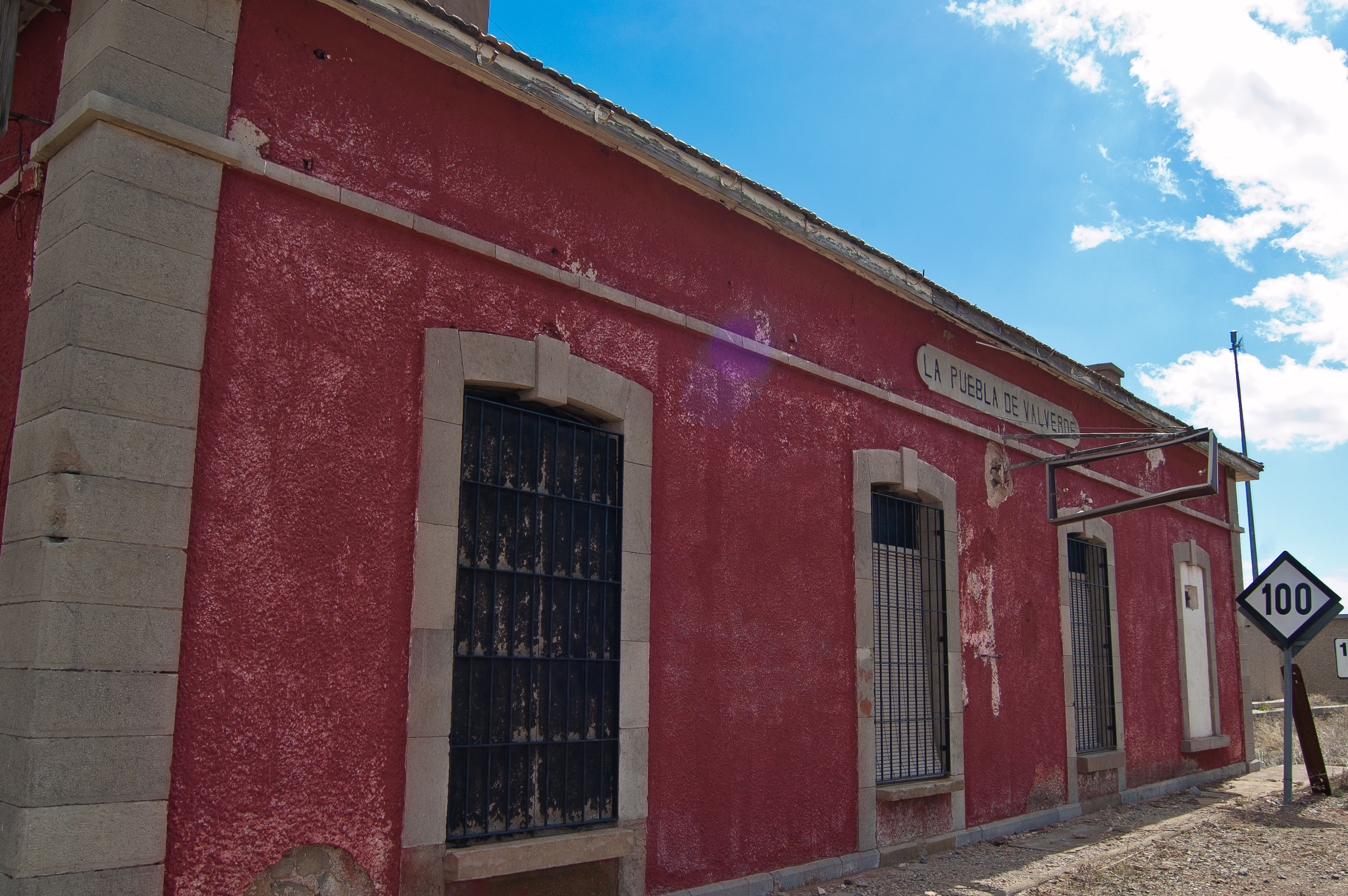
When you reach kilometre marker 79, you cross the viaduct over the Barranco de la Yedra ravine and, after that we encounter an interpretative panel on the history of the old mining railway and the nearby town of La Puebla de Valverde. Farmhouses and Spanish junipers adorn the landscape, amidst unirrigated crops, with one kilometre of descent after another until we reach the junction with the A-2520 road. A small stretch of our route is then shared with the road, requiring caution, before we finally reach the old La Puebla de Valverde station. Here, the station building, its interpretive panel and rest area bring this stage of the Santander-Mediterranean Nature Trail to a close.
Managing Entities
Sites of Interest
Puntos de interés
Culture
- Teruel Station
- Valdecebro Station
- Masía la Botiosa farmhouse
- Masía de la Botiosa farmhouse
- Masía de la Botiosa de Enmedio farmhouse
Geology
Hydrography
Information
Infrastructure
- Tunnel 2
- Wind Turbines
- Tunnel 1
- La Puebla de Valverde station
- Puerto Escandón station
- Old La Puebla de Valverde station
Municipality
Hostel
Vegetation
Passport
Profile

 Harshness of natural environment
- 1. The environment is not risk-free
- 2. There are more than one risk factors
- 3. There are various risk factors
- 4. There are quite a lot of risk factors
- 5. There are many risk factors
 Guidance along the route
- 1. Well defined trails and crossings
- 2. There is a clearly marked trail and signage
- 3. Requires the identification of geographic features and cardinal points
- 4. Requires off-path navigation
- 5. The trail is interrupted by obstacles that have to be gone around
 Route difficulty
- 1. Walking on a flat surface
- 2. Trails with different types of path
- 3. Walking on stepped paths or irregular terrain
- 4. The use of hands or jumping over the terrain is necessary
- 5. The use of hands is required to progress
 Amount of effort needed
- 1. Up to 1 hour of continuous walking
- 2. Between 1 and 3 hours of continuous walking
- 3. Between 3 and 6 hours of continuous walking
- 4. Between 6 and 10 hours of actual walking
- 5. More than 10 hours of continuous walking
(Calculated according to the MIDE criteria for an average excursionist with a light load)
Highlights
Teruel
Although the city of Teruel was founded during the Christian conquest in 1171, remains have been found that indicate that this enclave was inhabited much earlier. This is confirmed by the Iberian settlement known as Turboleta, in Alto Chacón, as well as by some documents found which also prove the existence of a Moorish fortress in the upper part of the present-day city, known as Tirwal.
Teruel has lived through any number of historical conflicts, from the Middle Ages to the War of Independence and the Carlist Wars, and even the Spanish Civil War, with one of the bloodiest battles of that conflict fought here.
The main economic activity is tourism, largely due to the city's Mudejar art, for which it was declared a World Heritage Site by UNESCO in 1986. The most outstanding examples are the Tower of San Pedro and the Cathedral, both from the 13th century, and the Tower of El Salvador and the Tower of San Martín, from the 14th century.
In addition, in the 20th century an architectural style inspired by the Mudejar style emerged, known as neo-Mudejar, the most representative examples of which are the door on the south façade of the Cathedral and the staircase linking the historic centre with the railway station.
Local festivals take place in the first fortnight of July, with another celebration held on the weekend closest to 14 February in memory of Los Amantes de Teruel, the ill-fated love story of Isabel de Segura and Diego de Marcilla.
La Puebla de Valverde
This town is located in the province of Teruel in the comarca of Gúdar-Javalambre. The Spanish Civil War very much marks its recent history. Its architectural heritage includes the Church of Santa Emerenciana, the Shrine of Loreto and a handful of noble houses built between the 17th and 18th centuries.
Local festivals take place here on the second Sunday in September in honour of La Virgen de Valverde and the most outstanding local gastronomic product is the black truffle (Tuber melanosporum) grown in the municipality and known for its excellent quality thanks to the unique environmental conditions.
Multimedia


Downloads

GPS Downloads


Documents

Cyclability
CICLABILITY
This Cyclostage corresponds to stage Teruel - Puebla de Valverde and stage La Puebla de Valverde - Albentosa of the Nature Trail
PROFILE

TYPE OF ROADS, PORTAGES & DIFFICULTY

TEST

SAFETY RECOMMENDATIONS
- There are several road junctions, a multitude of road junctions, several sections shared with motor vehicles, three tunnels equipped with artificial lighting and one tunnel without lighting.
GENERAL RECOMMENDATIONS
- Find out about the technical aspects of the route and the weather on the day.
- Take care of the environment. Take care not to disturb animals or damage vegetation. Respect private areas. - You must give priority to pedestrians and comply with general traffic rules.
- The environment in which you will be riding is open, free to move around and an area where many activities are carried out (sporting, forestry, livestock and agricultural activities).
- Always have an understanding, prudent, responsible and respectful attitude.