


Net of Nature
Trails

Esla Greenway Nature Trail







Description
Following the "Charango train" between brooms in a landscape inhabited since the Neolithic
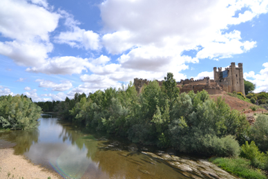
The route begins at Valencia de Don Juan, in the south of the province of Leon, a Vacceo settlement located on the site now occupied by the ruins of a castle. This town, which is also known as Coyanza, was given its current name in honour of Prince Juan of Castile, the first Duke of the Villa, and son of Alphonse X.
This route follows the old railway line that ran from Medina de Rioseco to Palanquinos. It was brought into service by the Castille Secondary Railways Company, which operated a network of modest narrow-gauge railway lines that provided a means of transporting agricultural and industrial produce from the Tierra de Campos region. This train was so slow that it was popularly known as the Charango train or the Donkey train.
To reach the starting point of this nature trail, the first thing is to leave Valencia de Don Juan via the LE-512 road, heading towards Fresno de la Vega, known as the Palanquinos Road. After leaving the town centre, take the second dirt track on the right – the same route that leads to the nursery. At the first junction, continue along the path on the right and, at the second fork, kilometre marker 0 sits on the right of the path.
The first section of the route follows a dirt track through poplar groves and farmland, which turns into a concrete road after 600 metres as it reaches a housing estate on the outskirts of Valencia de Don Juan. Once in the town centre, the route features a tarmac lane separate from traffic, and the junctions with the streets are clearly signposted with pedestrian crossings, ensuring the safety of those using the route.
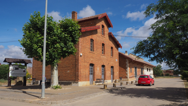
To the right of the route, at the entrance to the town, stands the old Valencia de Don Juan railway station. The complex comprises two buildings, including the three-storeys-high main building built of brick with wooden eaves and a flat-tiled roof. Following their restoration, part of these premises now houses municipal offices.
On leaving the town, next to the sports centre, cross the LE-512 road, taking the utmost care. From this point onwards, the road surface changes to compacted gravel and the landscape begins to reveal an interesting mix of vegetation and crops. Acacias (Acacia sp.), floriferous greenweed (Genista florida), elms (Ulmus sp.), common walnut trees (Juglans regia), hybrid plane trees (Platanus hispanica) and a few fruit trees line the route, marking the boundaries of corn fields (Zea mays), and sunflower (Helianthus annus) and cereal fields. The routes continues straight on, gradually closer to the road to Castrofuerte, crossing several bridges over small brooks as well as some agricultural trails.
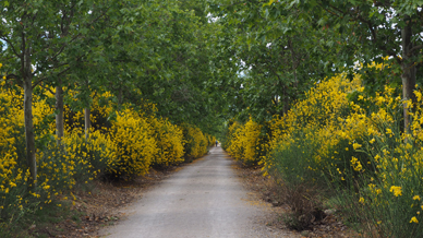
At around kilometre marker 7, it reaches the Bracas recreation area, surrounded by poplar groves and large broom bushes, also known as hawthorn. When hawthorn blooms, its sweet scent accompanies walkers for almost the entire route, making it one of the most distinctive features of this stage.
The route goes on surrounded by agricultural fields up to kilometre point 10, where it turns again into a tarmac road. From here, the village of Castrofuerte can be seen; the route heads towards it, crossing several farm tracks, at which points the path continues straight on. The route ends next to the access road to the town, where a small fountain welcomes visitors. Just a few metres further on, continuing straight ahead, the route arrives at the old Castrofuerte railway station, which has been restored in a style very similar to the one in Valencia de Don Juan, although it is currently disused.
Management entities:
Sites of interest
Puntos de interés
Culture
Hydrography
Infrastructure
Municipality
Hostel
Profile
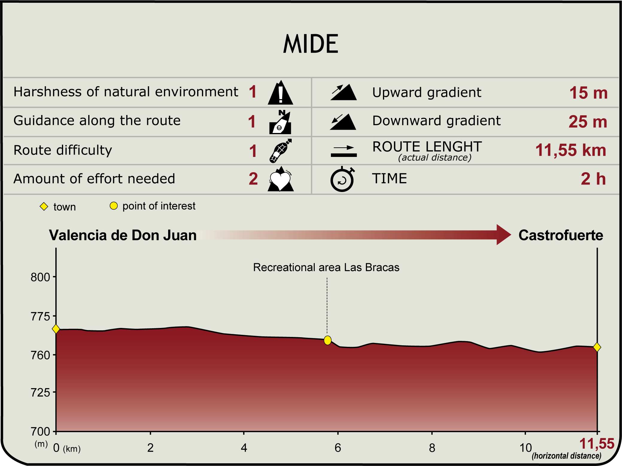
 Harshness of natural environment
- 1. The environment is not risk-free
- 2. There are more than one risk factors
- 3. There are various risk factors
- 4. There are quite a lot of risk factors
- 5. There are many risk factors
 Guidance along the route
- 1. Well defined trails and crossings
- 2. There is a clearly marked trail and signage
- 3. Requires the identification of geographic features and cardinal points
- 4. Requires off-path navigation
- 5. The trail is interrupted by obstacles that have to be gone around
 Route difficulty
- 1. Walking on a flat surface
- 2. Trails with different types of path
- 3. Walking on stepped paths or irregular terrain
- 4. The use of hands or jumping over the terrain is necessary
- 5. The use of hands is required to progress
 Amount of effort needed
- 1. Up to 1 hour of continuous walking
- 2. Between 1 and 3 hours of continuous walking
- 3. Between 3 and 6 hours of continuous walking
- 4. Between 6 and 10 hours of actual walking
- 5. More than 10 hours of continuous walking
(Calculated according to the MIDE criteria for an average excursionist with a light load)
Highlights
Further information
Castle of Coyanza (Valencia de Don Juan)
The Castle of Coyanza, given National Monument status by virtue of Decree of 3 June 1931, was erected in the 15th century on top of a former construction built on a ruined Iron Age hillfort settlement.
It comprises a moat, a second wall and a great crenellated wall with three-cube towers. To the south stands the Keep, alongside some sections of the primitive wall that used to circle the town in the past.
The premises, open to the public, are partly preserved and restored.
The premises belong to the Board of the Instituto de Valencia de Don Juan and is open for tourist purposes.
Observation point over the Esla and "Jardín de los Patos" (Duck garden)
In the Middle Ages, Valencia de Don Juan was called Coyanza, and its castle still popularly goes by that name.
Next to the castle, in the higher part of the town, there is a viewpoint over the Esla where tourists can enjoy a wonderful view over the Esla valley. Thanks to its natural beauty, this place has become a place of obligatory visit for all visitors.
Also in this area of Coyanza, tourist can enjoy the Duck Garden, the local park. The sight of the little ones throwing breadcrumbs to the ducks that live in the pond and having a great time is an usual one. The park has also a kiosk where walkers can rest, and a bandstand used by the music band to play on summer nights. Besides, a series of memorial plaques about the history of the town are scattered around the park.
The railway line from Medina de Rioseco to Palanquinos
The Castilla Secondary Railways Company was formed following the merger of several companies that had established a series of narrow-gauge railways in Tierra de Campos, linking the provinces of León, Palencia, Valladolid and Zamora. The first of these lines to be opened was the Valladolid–San Bartolomé–Medina de Rioseco line, in 1884, followed by the Villalón de Campos–Palencia section in 1912 and the Medina de Rioseco–Palanquinos section in 1917. Trains operated by the Valladolid to Medina de Rioseco Economic Railway Company also ran from Valladolid to Medina de Rioseco.
In 1934, the State took over the management of all the lines leading to Medina de Rioseco, incorporating them into the Spanish Secondary Railways Company. This company set up a separate company specifically for this vast network of narrow-gauge railways (which, at over 200 km, became the most extensive network of its kind), naming it the Castilla Railways Company and Spanish Secondary Railways Company, although it was commonly known as “Castilla Secondary Railways” and the train that ran on those lines was so slow that it was nicknamed the Donkey Train (Tren Burra).
The state took over this line to integrate it into the FEVE (Spanish Narrow-Gauge Railways) network in 1965, but a few years later, in 1969, services on these lines were permanently suspended. Today, this heritage can be explored via two walking routes that start from an information panel situated next to the bridge leading to Torres de Segre. The first offers a gentle walk along the River Segre, with access to two birdwatching spots, whilst the second leads to the Utxesa reservoir, largely following the old FECSA patrol path.
Multimedia


Downloads

GPS Downloads


Documents

Cyclability
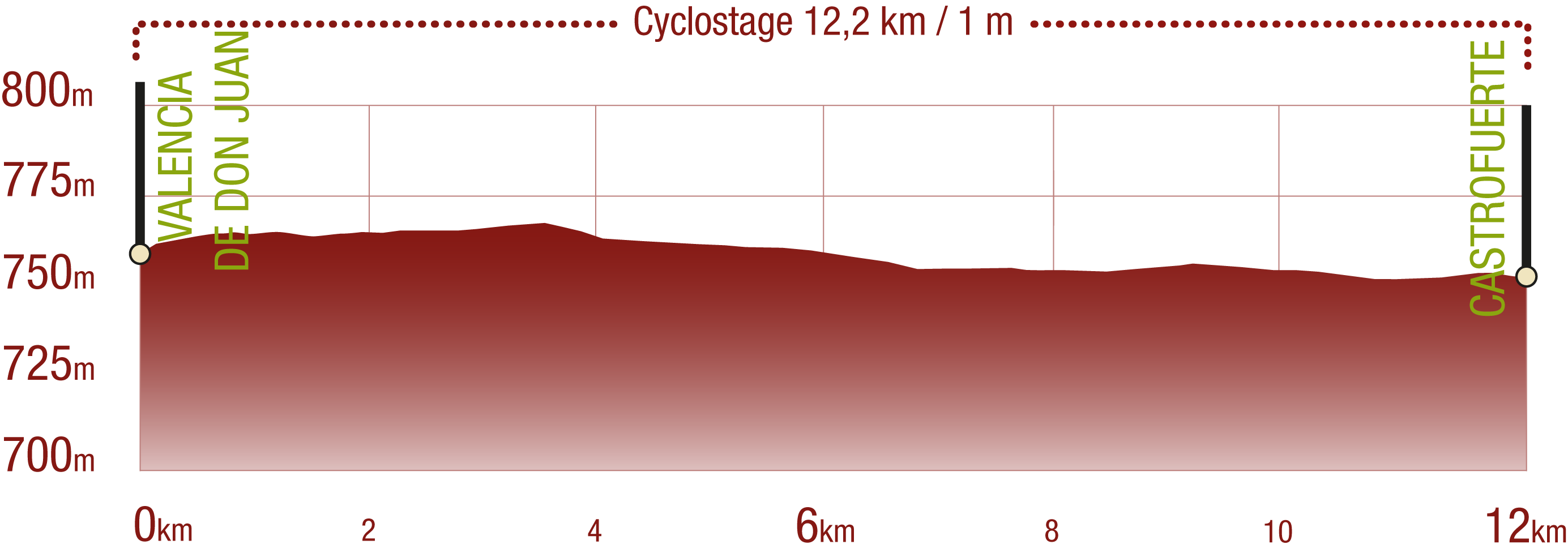
PROFILE
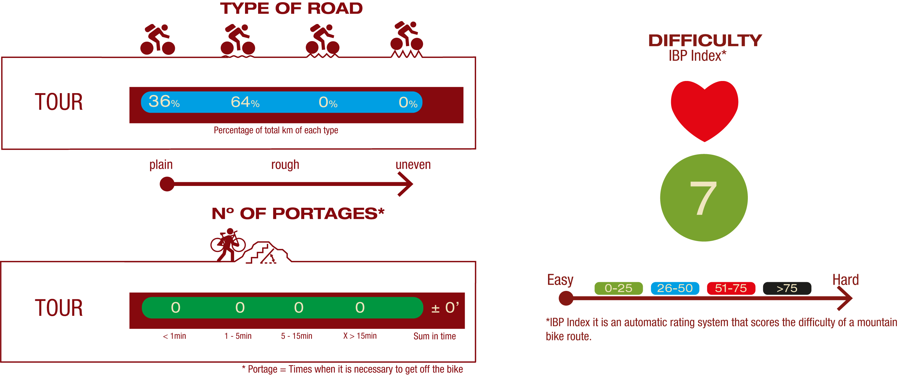
TYPE OF ROADS, PORTAGES & DIFFICULTY
TEST

SAFETY RECOMMENDATIONS
- Special attention should be paid at the intersection of the road LE-512 and at street crossings in urban areas.
- At intersections with dirt roads, it is recommended to slow down to reduce the risk.
- Be careful of the bumps caused by the poor condition of the pavement at the end of the road.
GENERAL RECOMMENDATIONS
- Find out about the technical aspects of the route and the weather on the day.
- Take care of the environment. Take care not to disturb animals or damage vegetation. Respect private areas.
- You must give priority to pedestrians and comply with general traffic rules.
- The environment in which you will be riding is open, free to move around and an area where many activities are carried out (sporting, forestry, livestock and agricultural activities).
- Always have an understanding, prudent, responsible and respectful attitude.