
 del Camino Natural de La Palma")
Net of Nature
Trails

Stage 2: Roque de los Muchachos – Refugio de El Pilar
Description
The pen cannot capture in words what is forever etched in the retina
This stage of almost 27 km leads the hiker through the heart of the island of La Palma, which is none other than the Caldera de Taburiente National Park. It starts at the majestic Roque de los Muchachos and continues eastwards along the ridge of the Caldera. Along the way, different peaks will be reached and spectacular views of ravines that overwhelm the sense of sight with their beauty. As we change course to the south, the extensive pine forests of Canary Island pine (Pinus canariensis) stand solemn and majestic. On the final stretch, the path plays with the Cumbre Nueva or La Hilera track, offering the beauty and freshness of the laurel forest, finally reaching El Pilar Recreational Area.

This spectacular stage, almost 27 km long, starts at the information point of the Caldera de Taburiente National Park, located at the iconic Roque de los Muchachos, one of the most iconic sites on the island of La Palma.
After enjoying the obligatory visit to the Roque de los Muchachos, the route departs from the small car park, advancing along a narrow cobbled path, accompanied by the numerous telescopes located in this area.
The road meanders, adapting to the steep terrain, with continuous ascents and descents that offer a constant challenge. Looking back, you can still see the Roque de los Muchachos and contemplate the landscape, enjoying the chromatic variety offered by the different layers of soil of the different ravines that can be seen.
Leaving a new telescope to the left, the path reaches the Fuente Nueva Peak, which rises to 2,366 m above sea level, crowned by a trigonometrical station. This element, which belongs to the National Geographic Institute, forms part of a large network distributed throughout the national territory, and is of vital importance for carrying out all types of topographic and cartographic work.
")
As we continue along the route, we can see the next climb, while to the right, the spectacular landscape of the Caldera de Taburiente National Park, declared as such in 1954. The park is not only a natural treasure, but also a Special Protection Area for Birds (SPA), Biosphere Reserve and Starlight Destination since 2012.
During these first few kilometres of the stage, the altitude marks the predominance of a low and resistant scrubland, adapted to the harsh climate conditions of the place, with the red or pink tajinaste (Echium wildpretii) standing out among all the species, which with its spectacular flowers gives colour to one of the typical snapshots of the island of La Palma.
The itinerary advances close to the LP-4 road, reaching the so-called Pared de Roberto and shortly after, it reaches the Mirador de Los Andenes, next to the aforementioned road. Here, hikers can continue to enjoy the Caldera de Taburiente and motor tourists can look out over it. National Park information signs warn of the danger of tackling the next section in winter and in icy conditions, so walkers should plan their journey accordingly and heed the signs.
The route continues skirting the ridge of the Caldera de Taburiente, leaving the Barranco de Gallegos ravine behind on our left and the Barranco del Diablo ravine on the right. The route gradually turns in a south-easterly direction, reaching the Pico de la Cruz, at an altitude of 2351 m, marked by a new trigonometrical station. A little further on is the Pico Cruz Sur Amateur Astronomical Viewpoint, where an interpretative panel provides information on how to enjoy the sights on clear nights.

There is a succession of uphill and downhill sections, as well as ravines, leaving the Barranco de La Fuente de Vizcaíno ravine on the left and the Barranco de Los Guanches ravine on the right. As you climb to altitudes of over two thousand metres, the hiker walks above the sea of clouds, with the silhouette of the spectacular Teide, the highest peak in Spain and also a National Park on the neighbouring island of Tenerife, towering above to the east. The route now heads south, reaching the start of the Barranco Hondo ravine on the left and the Barranco de Altaguna ravine on the right, before reaching the Pico de la Nieves a short while later. At an altitude of 2239 m, this peak culminates in a wooden cross that dominates the surroundings.
From here, the path starts to zigzag downwards, losing altitude and changing floors vegetation with the changing altitude, with the first specimens of Canary Island pine (Pinus canariensis) appearing. This tree, a symbol of the island of La Palma, is the only native pine species capable of resprouting from the trunk, a crucial adaptation to the fires caused, among other things, by volcanic eruptions.
As we descend we can see how the pine forest is gaining prominence, with its long needles arranged in threes rocked by the wind, which is very frequent on this stage. The landscape continues to be impressive and its immensity is not fully reflected in photographs or written descriptions, so it is recommended that hikers, provided they have enough time, make a few stops to appreciate the grandeur of the surroundings.
The path continues along the ravines on both sides of the route, with the Barranco de la Piedra Majorera ravine on the right and the Barranco de la Madera ravine on the left, both of which have been aptly named to reflect their natural environments. The Tagoror and La Erita petroglyphs are also close to the route, historical remains that add a mystical touch to the route. Shortly after, we reach the Lomo Corralejo, descending along new zig-zag path that climbs up along the crest of the mountain with views of a landscape so astonishingly spectacular it's hard not know where to look, intoxicated by so much beauty.

Due to the technical demands and the length of the stage, it is crucially important to plan well in advance. Fortunately, there are plenty of information signs along the route. At this point we find one with information on the remaining distance to different exits and escape routes, which can help to avoid unnecessary risks and/or to solve any setbacks or unforeseen incidents.
The hiker continues on this stage, perplexed by the landscape that surrounds him, reaching the Punta de Los Roques Refuge, an idyllic place to spend the night or simply take refuge from bad weather, equipped with water and electricity. The refuge is run on a system of respect and collective care of this small building located in one of the largest places on the island, scenically speaking.
The route descends steadily downhill to a point where you can see the west coast of the island. On a clear day, you can clearly make out the effects of the eruption of the Tajogaite volcano of 19 September 2021 and which lasted 85 days.
Further on, we reach the Pico Corralejo, at an altitude of 2,044 m, where a new trigonometrical station marks the highest point. Enjoying the extensive Canary Island pine forest and admiring its amazing capacity for sprouting and regeneration, we slowly leave the ridge of the Caldera de Taburiente behind, as the physical demands of the walk ease up somewhat.
The route continues to reach a new peak, in this case to the right of the route: Pico de las Ovejas which, at 1854 m, illustrates how much we have descended already. A short while later, around Roques de la Perra, the first specimens of typical laurel forest species can be seen, intermingled in the pine forest which gradually begins to dominate the coniferous forest.

After a further zigzagging downhill we reach the Cumbre Nueva track, also known as La Hilera. A few metres further along this track, we leave it after a horseshoe bend for a path that plunges us deep into the laurel forest. This cool, sombre setting evokes scenes from fairytales and legends of mythological beings. The path crosses the forest track again briefly before continuing on to the last part of the stage, the least demanding, with 6.5 km to go.
Along the path, you can enjoy the dense orchard that makes up the monteverde, where the odd Canary Island pine tree creeps into these forests full of biodiversity. The kilometres follow one after the other, approaching the forest track on a couple of occasions, to then continue along it for a few metres, taking the path again in the vicinity of a firebreak.
A short while later, after passing by some telecommunication antennas, we descend to the Pista de Cumbre Nueva track, for a long stretch that offers the change to recover somewhat after the intense first kilometres of the stage. The path then veers to the left of the track, crossing it a total of six times, changing at each crossing the side on which we leave the Pista de Cumbre Nueva. Despite the many crossings, the route is easy to follow thanks to good signposting and the constant proximity of the track, which serves as a reliable guide.
The vegetation remains dense and exuberant, typical of these laurel forests which benefit from the horizontal rainfall caused by the frequent fogs in the area. The route continues through the Cumbre Vieja Natural Park and, after the sixth and last junction with the track, the Canary Island pine forest curiously emerges once again. The hiker returns to the track shortly before reaching the LP-301 road, which we follow carefully for just over 200 m, as far as the El Pilar Recreational Area and with it the end of this spectacular stage. This Recreational Area has a multitude of services including parking, a bus stop, children's play area, barbecues, picnic areas and the El Pilar - Cumbre Vieja Visitors’ Centre.
Sites of interest
Puntos de interés
Culture
Information
Orography
Hostel
Profile
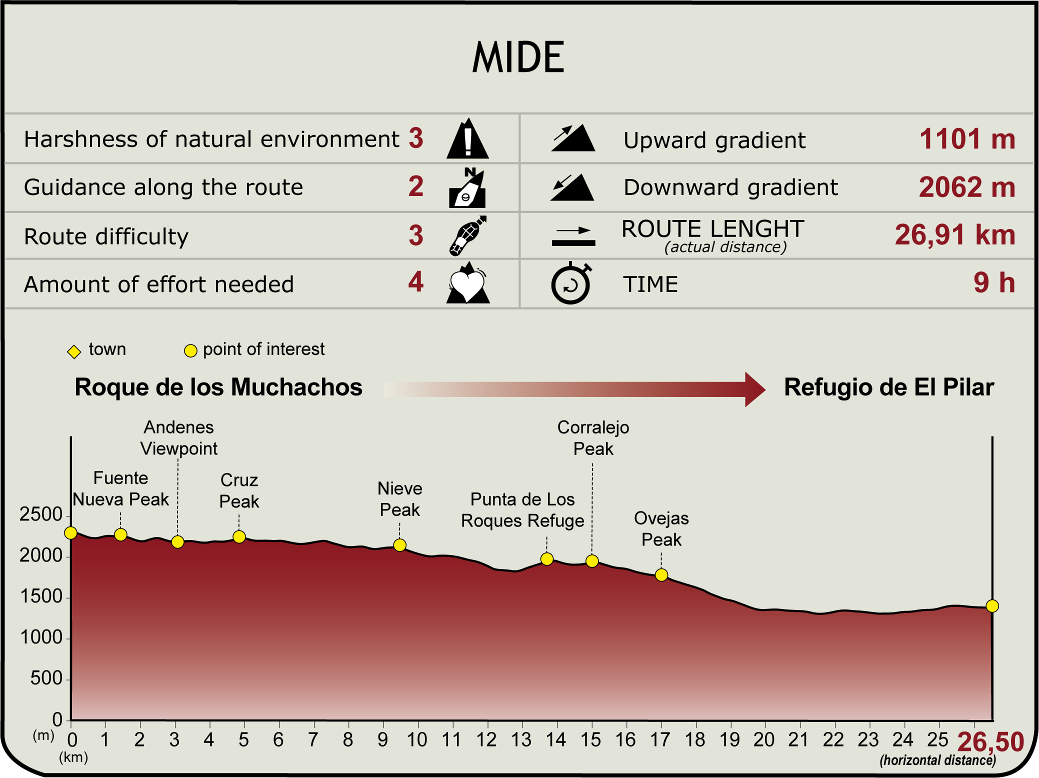
 Harshness of natural environment
- 1. The environment is not risk-free
- 2. There are more than one risk factors
- 3. There are various risk factors
- 4. There are quite a lot of risk factors
- 5. There are many risk factors
 Guidance along the route
- 1. Well defined trails and crossings
- 2. There is a clearly marked trail and signage
- 3. Requires the identification of geographic features and cardinal points
- 4. Requires off-path navigation
- 5. The trail is interrupted by obstacles that have to be gone around
 Route difficulty
- 1. Walking on a flat surface
- 2. Trails with different types of path
- 3. Walking on stepped paths or irregular terrain
- 4. The use of hands or jumping over the terrain is necessary
- 5. The use of hands is required to progress
 Amount of effort needed
- 1. Up to 1 hour of continuous walking
- 2. Between 1 and 3 hours of continuous walking
- 3. Between 3 and 6 hours of continuous walking
- 4. Between 6 and 10 hours of actual walking
- 5. More than 10 hours of continuous walking
(Calculated according to the MIDE criteria for an average excursionist with a light load)
Highlights
Further information
Caldera de Taburiente Natural Park
The Caldera de Taburiente National Park is a natural treasure on the island of La Palma that captivates nature lovers and explorers. Its geological formation, as a volcanic caldera, provides a unique diversity of landscapes, from high peaks to deep ravines, as well as Canary Island pine forests (Pinus canariensis), waterfalls, such as the famous Cascada de Colores waterfall, streams and cliffs, creating a fascinating landscape.
The name "Taburiente" comes from the language of the Benahoaritas, the indigenous inhabitants of La Palma before the Castilian conquest in the 15th century. Although the exact meaning is unclear, it is presumed to be related to the name of an ancient tribe or place on the island.
The Caldera de Taburiente is an impressive natural monument that was formed over millions of years, combining volcanic and erosive processes. It all began approximately 3 million years ago, with a series of eruptions that raised the present-day base of the island from the ocean floor. During the Pleistocene, around 1.6 million years ago, the collapse of the great volcano created a huge depression that gave rise to the Aridane Valley and the famous volcanic caldera. Over time, erosion from fluvial activity has continued to sculpt the caldera to this day, with weathering and other erosional processes shaping the landscape.
The biodiversity of the Caldera de Taburiente is truly extraordinary, with unique species of flora and fauna, which have adapted to the specific conditions of the island and the different bioclimatic levels. From sea level to the 2,426 m high Roque de los Muchachos, the caldera is home to an incredible natural wealth. Among the most notable species are the emblematic Canary Island pine and the fayal-brezal forest. The latter is a plant formation characteristic of Macaronesia, consisting mainly of the species known as faya (Myrica faya) and heather (Erica spp.), which are usually found in areas of higher humidity and altitude, thus contributing to the islands' biological diversity. We cannot overlook the importance of the colourful, reddish and blue flowers of the Echium wildpretii species, which add a distinctive beauty to the landscape. Other species can also be observed, such as the coxcomb (Adenocarpus viscosus) and spurge (Euphorbia canariensis), visible in the drier areas, which also play a crucial role in the botanic diversity of the area.
In terms of animal biodiversity, the Caldera de Taburiente is home to a fascinating variety of species that contribute to the wealth of its ecosystem. Among the majestic birds that inhabit this environment, we find not only the kestrel (Falco tinnunculus) and the palm crow (Corvus monedula hesperius), but also the canary(Serinus canaria), endemic to the region, which brings a special singularity to the local birdlife. Other notable birds include Bulwer's petrel (Bulweria bulwerii) and the peregrine falcon (Falco peregrinus), which find the park's diverse habitats an essential refuge.
In the reptile kingdom, the La Palma giant lizard (Gallotia auaritae) stands out as a unique species on the island. The wealth of insects also contributes to the biological diversity of the park. Among them, the Caldera beetle (Apalus bimaculatus) and the lemon verbena butterfly (Pyronia bathseba) are examples of the numerous species that find their home in the varied habitats that make up the park. The conservation of these habitats is essential to preserve the integrity of the endemic fauna and to ensure a sustainable ecological balance in the region. That's why the Caldera de Taburiente is protected as a National Park, with the status of Biosphere Reserve and Special Area of Conservation under the Natura 2000 Network. This protection status is of critical importance not only to preserve biodiversity, but also fundamental ecological processes. These unique habitats benefit from exceptional climate values, such as subtropical conditions and the influence of the trade winds, contributing to the formation of diverse microclimates.
For hiking enthusiasts, the park offers a network of trails, the "Sendero de los Roques" being one of the best known, offering breathtaking panoramic views of the caldera and, on a clear day, of the islands of Tenerife, El Hierro and La Gomera. Its remote location and low light pollution make it an ideal place for astronomical observation, contributing to La Palma's recognition as a Starlight Reserve. That is why, on the summit of the Roque de los Muchachos, there is the telescope array of the Roque de los Muchachos Astronomical Observatory, a place of astronomical research of worldwide scientific relevance.
Culturally, the Caldera de Taburiente has a special significance for the people of La Palma. Before the Castilian conquest, it was considered sacred by the Benahoaritas, the original inhabitants of La Palma, who saw it as a spiritual place and home to the sun god Magec. After the conquest, the area was used for agriculture and livestock farming, leaving traces of human intervention in the area, such as cultivation terraces and old roads, highlighting the high water value of the caldera. In short, the Caldera de Taburiente is an enriching experience, both in terms of nature and history.
Multimedia


Downloads


