
Net of Nature
Trails

La Palma Nature Trail
Description
- - - - - - - -
IMPORTANT WARNING: DUE TO THE VOLCANIC ERUPTION THAT BEGUN IN 19/09/2021 IN CUMBRE VIEJA, THIS ITINERARY IS NOT PASSABLE IN SOME OF ITS SECTIONS!
- - - - - - - -
select a stage:

Through the lands of the Benahoaritas
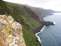
The La Palma Nature Trail, made up of the GR-130 "Camino Real de La Costa y Medianías” (Royal Way of the Coast and Middle Lands) and the GR-131 "El Bastón" long-distance walking trails, offers a unique experience for those looking to immerse themselves in the scenic, cultural and geological diversity of La Palma.
GR-130 Royal Way of the Coast and Middle Lands
This circular trail, starting at Plaza de España in Santa Cruz de La Palma, invites you to discover the island over eight fascinating stages. Along the route, there is an astonishing array of landscapes: from busy urban areas and quiet rural areas, to rolling fields of crops in the middle lands, dramatic ravines and lush pine and laurel forests. There is no shortage of arid regions dotted with the cardon, a cactus-like shrub which only serves to further enrich the experience. This trail features some marvellous natural wonders such as the Barranco del Agua ravine, the Guelguén Special Nature Reserve and the Los Volcanes de Aridane Natural Monument. At the northern end, part of the original route of the Camino Real has been preserved, offering a real connection with the history and landscape of La Palma.
GR-131 "El Bastón”
El Bastón is a challenging and spectacular route that starts in Puerto de Tazacorte and climbs up to the highest point of the island, the Roque de los Muchachos, at an altitude of 2,426 metres. From there, the trail follows the ridge of the Caldera de Taburiente, offering breathtaking views of the Aridane Valley and Santa Cruz de La Palma. The route then descends to the El Pilar Refuge and continues along the iconic Ruta de los Volcanes, passing craters such as Hoyo Negro, Duraznero and Montaña de Fuego, until it reaches the Faro de Fuencaliente lighthouse. Along this stretch, the landscape changes continuously, from green pine forests and arid volcanic peaks to coastlines and salt flats, offering breathtaking views of neighbouring islands of Tenerife and El Hierro. Both trails provide a comprehensive overview of La Palma, combining the history of ancient paths with the impressive natural and cultural diversity of the island. The La Palma Nature Trail is a unique opportunity to experience the island's rich geography and heritage, from its urban and rural areas to its impressive volcanic and coastal landscapes.
Highlights
Further information
Island of La Palma
La Palma is one of the seven islands that form the Canary archipelago. It is known as "Isla Bonita" (the beautiful island) both for its spectacular natural landscape, of which laurel and Canary pine forests are a highlight, and for its old colonial style villages and towns.
The early inhabitants of the La Palma called their island “Benahoare" (“My land”), and divided it into 12 cantons or dominions, each of which was ruled by a lord or “mencey”. The aboriginal population lived mostly off grazing (goats, sheep and pigs). Currently, livestock farming is a marginal activity and tourism has become the main economic engine of the island.
The island of La Palma was named a Biosphere Reserve in 2002, since it has two Natural Parks, as well as the National Park Caldera de Taburiente. These natural areas have been exceptionally well preserved thanks to the implementation of an economic model that combines sustainable tourism and traditional agriculture.
National Park of La Caldera de Taburiente
Caldera de Taburiente, with an area of 4,690 ha, was named a National Park on October 6, 1954. It is formed by a huge caldera-shaped cirque with a diameter of 8 km created by volcanic eruptions, massive landslides and the erosive action of wind and, specially, water.
The Caldera has elevation changes of up to 2,000 m, as well as an important network of brooks and streams that remains practically unspoiled thanks to the good preservation of the vegetation cover.
Among the many plant species this area is home to, the most important ones can be found in laurel forests: Canary Island fire tree (Myrica faya), tree heath (Erica arborea), and Canary Island pine (Pinus canariensis), main plant formation in the Park, and remarkable for its adaptation to fires.
Multimedia


2_141039.jpg)


Downloads

GPS Downloads


