
 del Camino Natural de La Palma")
Net of Nature
Trails

Stage 3: Barlovento – Santo Domingo de Garafía
Description
Exploring the north of the island among ravines and Canary Islands dragon trees.
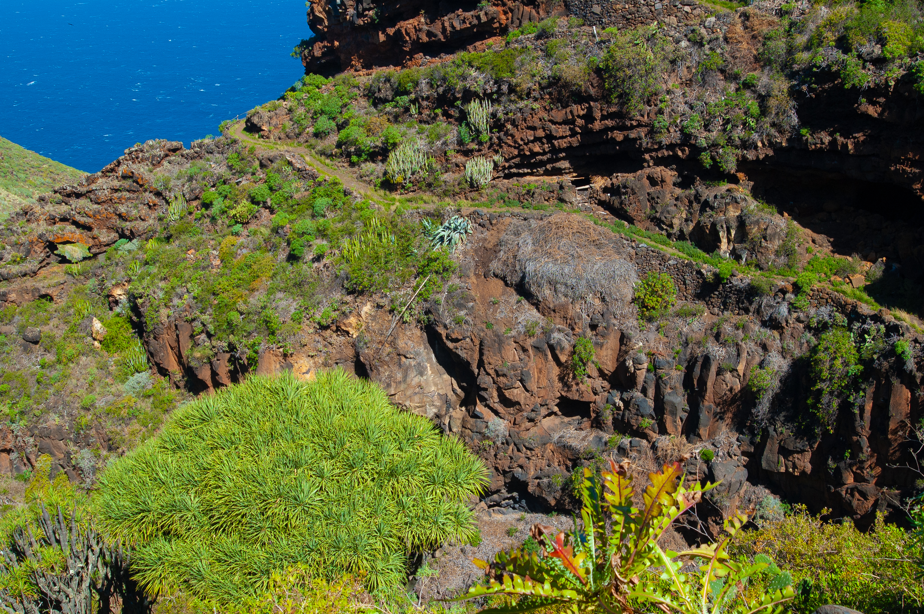
A demanding stage, almost 30 km through the rugged north of La Palma, from the town of Barlovento to Santo Domingo de Garafía. The trail follows a succession of ravines and protected natural spaces, with a multitude of plant formations, including masses of laurel, Hercules club and plenty of Canary Island dragon trees (Dracaena draco), which were an important economic driving force for those brave settlers until not so long ago.

The third stage of the GR-130 La Palma Nature Trail begins in the town of Barlovento, at the roundabout between the LP-1 and LP-109 roads. The town hall and the Church of Nuestra Señora del Rosario, as well as the old optic of the Faro de Barlovento lighthouse, located next to these buildings.
Once we have enjoyed a visit to Barlovento, we embark on this long and challenging 30 km stage across the north La Palma. The route starts on the LP-1, so extreme caution with traffic is recommended. After a slight turn, before completing the first kilometre, take the asphalted track on the right, flanked by houses and small vegetable gardens. A little further on, the track turns sharply to the left and becomes a dirt road.

After a winding stretch halfway up the slope, the first Canary Island dragon trees (Dracaena draco), emblematic plants of the area, begin to appear. Approaching the first houses of La Tosca, the resilience of the inhabitants of the north of the island becomes palpable, in order to settle in this hostile environment. This area, which did not have asphalted roads until the mid-20th century, survived mainly on the sale of dragon tree leaves for traditional basketry, which explains the abundance of this species in the area.
The route continues along the asphalted track to the La Tosca fountain, once used as an outdoor washing place. When you reach the fountain, take the track on the right, descending as indicated by the Caminos Naturales signage.
Further on, after another turn to the left, the trial becomes narrower and turns into a paved path, as the surroundings become more picturesque. Here, it crosses a small area where species typical of the laurel forest intermingle with heathland, creating a charming atmosphere in the Barranco de Topaciegas ravine, plunging the us into the Monteverde de Gallegos-Franceses Special Area of Conservation.

We are taken through a series of ravines, and next up is the Barranco de la Vica ravine, known for its interesting flora, and largely similar to the previous one. On reaching the first houses of La Palmita, after almost four kilometres, a typical decorated cross greets us as we cross the district. It is now time for a sharp descent to the bottom of the Barranco de Gallegos ravine, taking us into the Guelguén Special Nature Reserve. After this descent, typically of this stage, the trail turns back uphill again, zigzagging occasionally with the sole purpose of softening the slope to be overcome.
Shortly before the six-kilometre mark, we reach the area of Gallegos, with the houses of Lomo de la Crucita in emerging first and in parallel the houses of Lomo de la Cancela, both illustrative of the harshness of inhabiting these lands.
The path continues to approach the coast with a steep descent reaching the Gallegos viewpoint, also known as the Lomo de la Cancela viewpoint. From here, we can enjoy spectacular panoramic views of the island's coastline and the Atlantic Ocean as well as the remains of the old Gallegos dock, which in the past used to supply these villages. Goods were transported up the steep slopes to villages.
Continuing, we zigzag our way up and down the Barranco de Melchor Pérez ravine and then the Barranco de Franceses ravine. Along the route, the moist breeze from the Atlantic Ocean will help us catch our breath.
 on the Nature Trail")
Progressing further, the route widens and the gradient eases slightly as it reaches the first house in one of the neighbourhoods that make up Franceses. After a short zigzag, we reach the main asphalted track offering some relief to regain strength as we cross the district of Los Franceses. We then pass a new, smaller settlement belonging to Los Franceses, before continuing along what is known Camino de la Fajana, a wide, well-surfaced track. After a series of bends, we temporarily leave the track for a path on the right which, after a short windy section, returns to the main track.
Just before tackling the last stretch of the descent towards the banana plantations that announce our arrival in the village of La Fajana, the route turns sharply to the left, where there is the option of a quick visit to Los Frances beach and the remains of what was once the old port.
The route then descends to the bottom of the Barranco de los Hombres ravine, before immediately tackling a vertiginous and tough ascent. After overcoming the most demanding ramps, we enter the Protected Landscape of El Tablado, before entering the village of the same name. The short walk through this small village is the perfect moment for a break to take in the traditional buildings and its small vegetable gardens where the famous Canarian potato is grown.
Once we have caught our breath, we face the next descent, this time into the Barranco Fagundo ravine, before heading back uphill again. The orography gives the walker a break, passing by the Mirador de La Calzada viewpoint, reaching a handful of scattered houses, the prelude to the last stretch of the route before reaching the town of Don Pedro.
After leaving the small village behind, the path crosses several minor ravines, entering the Monteverde de Don Pedro-Juan Adalid SCI. Here, small patches of laurel forest emerge, as the name monteverde indicates, and then a vegetation transition begins, caused by more sunshine and less rainfall, which will lead to more abundant Hercules club.
In the meantime, the kilometres continue to add up until they reach the crossroads with the asphalted track of the Juan Adalid Wind Farm, where the signs indicate to the hiker that they are facing the last six kilometres of this spectacular and at the same time demanding stage. From here we face a winding descent through the Barranco de Domingo Díaz ravine, before crossing the Barranco de El Mudo ravine and arriving in the village of El Palmar. This area, renowned for its agricultural tradition, features terraces built into the hillside, many of which are still in use today.
Numerous Canary Island dragon trees (Dracaena draco) dot the surroundings, just as the tail eases after a challenging few kilometres and we enter alternating stretches of dirt track and asphalt or cement path. One last ravine, dotted again with Canary Island dragon trees, lies ahead before finally arriving at the stage finish next to the Church of Nuestra Señora de la Luz in Santo Domingo de Garafía.
Puntos de interés
Culture
Municipality
Vegetation
Profile

 Harshness of natural environment
- 1. The environment is not risk-free
- 2. There are more than one risk factors
- 3. There are various risk factors
- 4. There are quite a lot of risk factors
- 5. There are many risk factors
 Guidance along the route
- 1. Well defined trails and crossings
- 2. There is a clearly marked trail and signage
- 3. Requires the identification of geographic features and cardinal points
- 4. Requires off-path navigation
- 5. The trail is interrupted by obstacles that have to be gone around
 Route difficulty
- 1. Walking on a flat surface
- 2. Trails with different types of path
- 3. Walking on stepped paths or irregular terrain
- 4. The use of hands or jumping over the terrain is necessary
- 5. The use of hands is required to progress
 Amount of effort needed
- 1. Up to 1 hour of continuous walking
- 2. Between 1 and 3 hours of continuous walking
- 3. Between 3 and 6 hours of continuous walking
- 4. Between 6 and 10 hours of actual walking
- 5. More than 10 hours of continuous walking
(Calculated according to the MIDE criteria for an average excursionist with a light load)
Highlights
Further information
El Palmar dragon tree forest
The dragon trees, specifically the Canary Island dragon tree Dracaena draco is the most representative of Canarian vegetation and cherished in many local legends. This endangered species is typical of the subtropical climate, characteristic of Macaronesia, where the Canary Islands, Madeira and Cape Verde are located, along with other species of this genus being found on the west coast of Africa.
These trees, known for their thick and robust trunks, change in appearance with age and their sap is unique in the plant world, thanks to its reddish hue. When in flower, they show white flowers and reddish-orange fruits on the tips of their branches.
They grow mainly in the thermophilic areas of the island, particularly on inaccessible cliffs and slopes with a certain degree of shade and humidity. Although in the past dragon trees formed dense forests, today their populations tend to be small and scattered, and can be found in ravines and inland areas of the north of La Palma. That's why a dragon tree forest is a natural treasure that highlights the importance of conserving biodiversity on the island, as well as being part of a natural heritage, unique in the world.
The dragon tree had a very special significance for the Benahoaritas, who attributed magical properties to it due to the intense red colour of its resin, known as 'dragon's blood' and used for medicinal purposes. The leaves were also used for fodder, rope making and other traditional uses.
Multimedia


Downloads

GPS Downloads


