

Net of Nature
Trails

Stage 4: S'Arenal d'en Castell - Tirant Cove
Description
Coves and pine forests
Stage 4 of the Camí de Cavalls runs along the north coast of Menorca, along the municipal district of Es Mercadal, from S'Arenal d'en Castell beach to Tirant Cove. In this stage, you will be able to visit some of the most characteristic ecosystems of the Mediterranean climate: cliffs, marshes, beaches, forests, agroforestry mosaics and the Bay of Foretells. The relationship between the island's inhabitants and the environment is evidenced in several of the enclaves through which you will pass in this stage, such as archaeological sites or tourist and leisure areas, as well as traditional cereal and salt harvesting and livestock farms, all which tell the story of the historical and cultural evolution of the island.

The information board marks the start of this stage is located between a group of holiday housing estates on the Vía de Ronda streets , on the cliffs over the western end of the S'Arenal d'en Castell beach. From here, the first kilometre of the route follows the path that connects S'Arenal d'en Castell with the Son Parc housing estate. It runs parallel to the cliff, so the ground is mainly rocky.
The area is an idyllic place carved by the northern tramontane winds and the action of the sea, and characterised by the presence of seabirds and the low Mediterranean scrubland. This plants such as the trèvol femella (Lotus cytisoides) or the sea fennel (Crithmum maritimun) cover the cliffs in a yellow hue. Scrubland is usually strongly conditioned by the winds, which prevent bushes to grow tall or carve them in an specific shape, as it is the case of creeping Juniperus turbinata.
After leaving the cliffs behind, this stage of the trail enters the tree-lined Son Parc residential complex, where you will walk mainly across asphalt roads or pavements. This development includes various services mainly related to the tourist sector. Following the trail along the streets of Son Parc, the route descends to the Prat de Son Saura marshland, a 40-hectare area protected and included in the Natura 2000 network. From there, you can access the Arenal de Son Saura beach, which is surrounded by patches of pine trees (Pinus sp.) and African tamarisk (Tamarix africana) and has a recovered dune system with important plant formations, such as common reed (Phragmites australis) and spiny rush (Juncus acutus), which have contributed to fixing the beach sands and improving their environmental quality.

The Camí de Cavalls leads from the car park of the Arenal de Son Saura beach, crossing a Menorcan gate, onto a path that surrounds the marches of the same name, and gradually widens and enters the wooded area of S'Albufera des Comte.
This section of the trail runs along 3.8 km of forest track with gentle slopes and goes through a typical Mediterranean coastal forest dominated by Aleppo pines (Pinus halepensis), strawberry trees (Arbustus unedo) and lentisk (Pistacia lentiscus) along with some evergreen oaks (Quercus ilex) and squat shrubs such as Montpellier cistus (Cistus monspeliensis) or green heather (Erica scoparia). In this area you may spot small mammals such as hedgehogs and different birds such as woodlark (Lullula arborea), booted eagles (Hieraaetus pennatus) and common kestrels (Falco tinnunculus).

After 4 km from Arenal de Son Saura the path leaves the forest and heads west into an agroforestry mosaic. In this section, after crossing a small stream surrounded by riverside bushes, the path runs along a kilometre of a gravel track low slope lined by the dry stone walls that divide the agricultural plots. A few metres from the beginning of this section there, you will find an access that that will allow you to approach the remains of the early Christian Basilica of Cap d'es Port de Fornells, from where the entire Bay of Fornells can be seen to the west, including the town of Ses Salines, some of its coves and islands and the Salinas de la Concepció salt evaporation ponds.
At the end of the track, the trail continues along the hard shoulder of the Me-7 road that connects Maó with Fornells; please be extremely careful and watch out for traffic. Continue for approximately 900 metres until you reach a roundabout; the trail takes the first exit and continues for a kilometre and a half in the direction of Fornells also along the hard shoulder of a road, in this case that of the Me-15. From this point onwards the route approaches the coast, bordering the western part of the Bay of Fornells, to reach the town of Ses Salines, where there a crossroads leads to the Playas de Fornells residential complex, where Tirant Cove is located.
The last kilometre and a half of this stage runs along a cycle and pedestrian lane that runs along Carrer E or Camí de Cala Tirant, in the direction of Playas de Fornells. There is a roundabout, where you must take the second exit leading to a leisure and restaurant area. After barely 300 m, the route turns left to reach the access to Tirant Cove, the end point of the stage.
Links of interest
Puntos de interés
Culture
Municipality
Orography
Profile

 Harshness of natural environment
- 1. The environment is not risk-free
- 2. There are more than one risk factors
- 3. There are various risk factors
- 4. There are quite a lot of risk factors
- 5. There are many risk factors
 Guidance along the route
- 1. Well defined trails and crossings
- 2. There is a clearly marked trail and signage
- 3. Requires the identification of geographic features and cardinal points
- 4. Requires off-path navigation
- 5. The trail is interrupted by obstacles that have to be gone around
 Route difficulty
- 1. Walking on a flat surface
- 2. Trails with different types of path
- 3. Walking on stepped paths or irregular terrain
- 4. The use of hands or jumping over the terrain is necessary
- 5. The use of hands is required to progress
 Amount of effort needed
- 1. Up to 1 hour of continuous walking
- 2. Between 1 and 3 hours of continuous walking
- 3. Between 3 and 6 hours of continuous walking
- 4. Between 6 and 10 hours of actual walking
- 5. More than 10 hours of continuous walking
(Calculated according to the MIDE criteria for an average excursionist with a light load)
Highlights
Early Christian Basilica of Cap d'es Port de Fornells
It is an early Christian building dating from the end of the 5th century AD or the beginning of the 6th century AD, which may have been in use during the 7th century AD.
The basilica was discovered in 1958, in the area furthest from the mouth of Fornells Bay, between Son Parc and Ses Salines. The remains evidence that this church was organised around a central nave with a rectangular floor plan facing east, around which were attached several rooms that underwent structural changes over time.
This central nave had a low apse in which a crypt was built in the shape of a Greek cross, which was unusual for the time and used the uneven terrain. This crypt was connected to the sanctuary by the stairs on the west side. At this point, the entrance door to the basilica and the choir, covered with a vaulted ceiling, were found collapsed inside the nave.
In a separate hall at the northeast end of the building is a baptismal font in the shape of a four-pointed star. The floor of the church is covered by opus signinum, a cement mass used in Roman times, and has plastered and painted walls.
The Museum of Menorca in Maó conserves some of the elements recovered from this basilica, including several decorated walls with inscriptions in Latin and Greek, as well as columns, pilasters, column capitals and bases, as well as a Roman stone sarcophagus and two marble fragments that seem to have been part of an altar. In addition, other more everyday objects were found, including a stone cross, a bronze cross and glass paste jewellery.
Fornells
Fornells is a coastal town with a seafaring and salt-harvesting tradition, located at the western mouth of the Bay of Fornells, on the north coast of Menorca. Nowadays, it belongs to the municipality of Es Mercadal, and has become a must if you love fine food or water sports.
Originally, Fornells was only the Castle of Sant Antoni, and which was used to defend the 5 km natural port that is the Bay of Fornells and of which only the foundations remain. The castle was active for over than a century, from its construction in 1637 until the end of the 18th century. More precisely, until 1782 when Charles III of Spain ordered the soldiers who guarded it to withdraw.
However, other inhabitants settled near the castle as it offered protection from attacks by Barbary pirates, decided not to abandon the settlement after the castle was left vacant, and the town has survived to the present day.
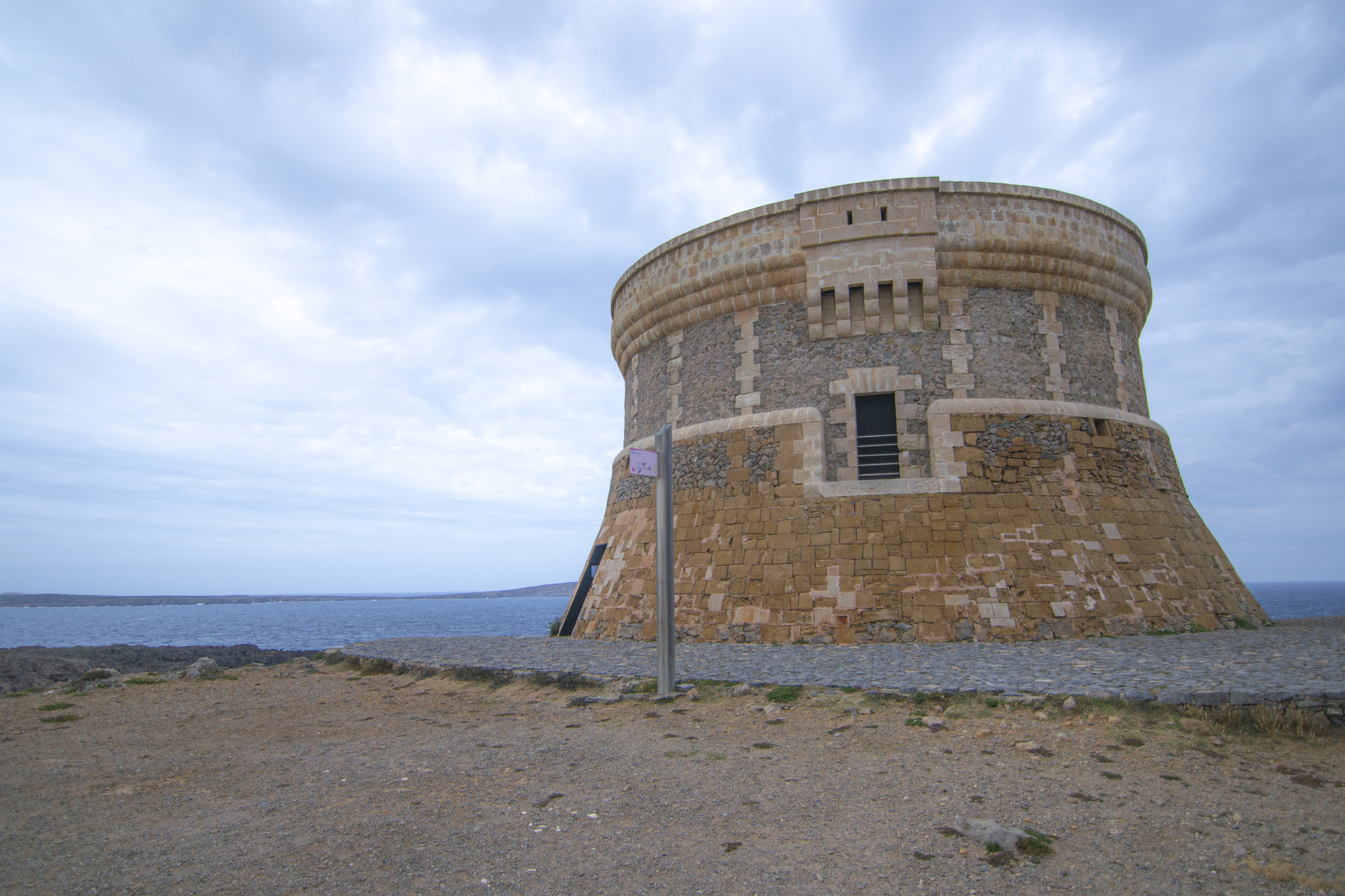
To the north of the town, at the top of the cliff, is the Fornells Tower, built at the end of the 18th century, possibly between 1801 and 1802, during the third British occupation of Menorca. This watchtower was part of a surveillance network built by British troops for defensive-military purposes. Most of these towers had the same architectural structure: a circular ground plan, three or four storeys high, each intended for a specific use, from bottom to top: storage, lodging and manoeuvring.
Multimedia


Downloads

GPS Downloads


