
Net of Nature
Trails

Stage 8: Puente Arenas - Trespaderne
Description
A Romanesque jewel in Valdivieso valley
Through this stage of the Nature Trail running through the Valdivieso valley, visitors can get up close to magnificent examples of Romanesque art. The route visits the Cereceda reservoir, which is of great ecological interest, and the village of Panizares, which houses the curious formation of the Cuchillos, sharp monoliths that are usually covered in mist. The route then ascends through the Sierra de la Tesla, which is crossed via the small Tartalés de los Montes gorge before returning to the river in the Horadada gorge, part of the Montes Obarenes Natural Area. At the confluence of the rivers Nela and Ebro lies the village of Trespaderne, the end point of the day’s walk.
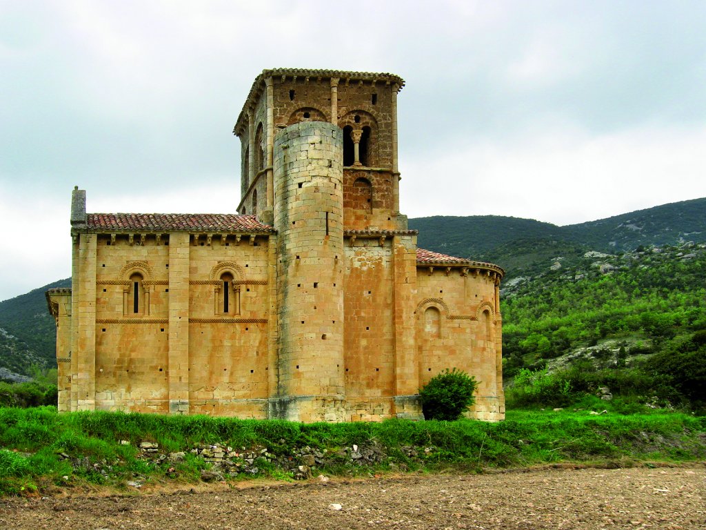
The stage begins beside the bridge, following the sign to San Pedro de Tejeda hermitage, undoubtedly the most outstanding heritage element in Valdivielso; it is the Las Merindades Romanesque style and is located some 900 m from the village. From this point, you will descend, heading east along the Cubilla path. The path then connects to a track that leads from the road and climbs up to the Sierra de la Tesla. Among fields, the path heads towards the BU-V-5314 road, which crosses the valley. After a few metres along this road, a track begins on the right that runs parallel to the Ebro and leads to Población de Valdivielso.
You will head south out of the village, crossing a picnic area near the River Ebro. The path continues parallel to the river until it reaches the Las Ventillas bridge, which connects with the N-232. After crossing the BU-V-5314 again, you will walk along the left bank until you reach a track that turns left and immediately thereafter turns right, descending to the riverbed. From here you will cross a stream beside a picnic area, before reaching the new bridge.
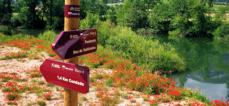
From this point you can access Condado on the right bank of the Ebro, but we suggest continuing along a nice detour leading to the Cereceda and Panizares reservoir. To do this, at the bridge, continue left along a wooded section to the Calentura spring. At this point, you will cross bridge and go along a path that continually rises and falls, and which leads to the Fuente Sagrero cave.

After another pine forest you will reach the BUV-5314 road. At this point you will descend to the Panizares bridge that crosses the Cereceda reservoir, a site of great ecological interest, with hillsides covered in vegetation and its varied fauna. You will then ascend S to Panizares, following a section of road. Not long after crossing the bridge, you will encounter a track on the right that will take you to the village, where the Cuchillos de Panizares, on the northern slope of the Sierra de la Tesla, stands out. These are curious, very sharp rocky monoliths, to which mists and fogs often cling, in one of the most characteristic images of the place.
Once you have reached the lower part of the village, follow the track that heads towards the Hoz de Valdivielso (Valdivielso Gorge). One kilometre later, the track ends and the route continues among gall oaks, boxwoods and pines by a fence that must be crossed to descend to the gorge.

Once you have reached this point, you must cross the place via Calle Real, which will lead you to the road that heads up to Tartalés de los Montes, thus going up the stream of the same name. At this site, a forest track starts in a south-easterly direction, following the basin of the Borcos ravine.
The Ebro Nature Trail continues its through pastureland surrounded by pines and gall oaks and, after passing a farm in the Laguna and passing several paths on either side, it reaches the Pedraco corral, where enormous crags enclose a cattle pen. Shortly thereafter, you will have to cross a small stream, after which the path ascends through pine trees to the Muñeca pass, which serves as the dividing line between Tartalés de los Montes and Tartalés de Cilla. From this point you can see the Siete Cruces boundary marker to the north, at an altitude of 1,163 m, and the Alto de la Tesla, which is over 1,100 m high. Here the path enters the Montes Obarenes-San Zadornil Natural Park.

Once you are up there, the route begins to descend towards the aforementioned village of Tartalés de Cilla, before briefly entering the Montes Obarenes-San Zadornil Natural Park parallel to the left bank of the Torcas stream and the Tejada de Cilla. It continues along Calle de la Iglesia and leaves the village, which has become a path, heading towards the fields at the end of the Horadada gorge. Its twelve kilometres of limestone house birds of prey, wild boar, roe deer, foxes, griffon vultures and sparrow hawks, amidst holm oak and pine forests.
The last part of the stage begins; after leaving the Cereceda/Trespaderne canal behind, it descends to the N-629 road, leading to Trespaderne, which is embedded in the Horadada gorge. The finish line is not far away, but first you must go under the Santander-Mediterráneo railway bridge to reach the Valdecastro bridge, where you can link up with stage 9.1. Shortly thereafter, the route enters an industrial estate and reaches the medieval bridge and the landscaped area that leads to the N-629 bridge.
Sites of interest
Puntos de interés
Culture
- Bolera de Población de Valdivielso
- Ermita San Pedro de Tejada
- Emeritorio rupestre de San Pedro
- Emeritorio rupestre Cueva de los Portugueses
- Castillo de Tedeja
Hydrography
Municipality
- Puente Arenas
- Panizares
- Hoz de Valdivielso
- Población de Valdivielso
- Tartalés de los Montes
- Trespaderne
Orography
Vegetation
Profile

 Harshness of natural environment
- 1. The environment is not risk-free
- 2. There are more than one risk factors
- 3. There are various risk factors
- 4. There are quite a lot of risk factors
- 5. There are many risk factors
 Guidance along the route
- 1. Well defined trails and crossings
- 2. There is a clearly marked trail and signage
- 3. Requires the identification of geographic features and cardinal points
- 4. Requires off-path navigation
- 5. The trail is interrupted by obstacles that have to be gone around
 Route difficulty
- 1. Walking on a flat surface
- 2. Trails with different types of path
- 3. Walking on stepped paths or irregular terrain
- 4. The use of hands or jumping over the terrain is necessary
- 5. The use of hands is required to progress
 Amount of effort needed
- 1. Up to 1 hour of continuous walking
- 2. Between 1 and 3 hours of continuous walking
- 3. Between 3 and 6 hours of continuous walking
- 4. Between 6 and 10 hours of actual walking
- 5. More than 10 hours of continuous walking
(Calculated according to the MIDE criteria for an average excursionist with a light load)
Highlights
Further information
The heritage of Valdivielso and Trespaderne
This Section begins near San Pedro de Tejeda, an 11th-12th century Romanesque shrine, and one of the finest examples of this style of art in Valdivielso Valley. The parish churches of Condado and Panizares are also Romanesque. At Hoz de Valdivielso, the church of San Cornelio y San Cipriano (15th-16th C.), the Herreran-style palace of Huidobro (16th C.), and the remains of the 11th century Romanesque shrine of Santa María de las Heras are noteworthy. Tartalés de los Montes has the Romanesque parish church of San Miguel (12th C.). At the edge of the town of Tartalés de Cilla (630 m), to the north of the road, is a sandstone outcrop where the hermit cave of San Pedro was excavated in the 7th-8th centuries. The parish church of San Martín can be traced back to the 12th century.
In Trespaderne, the most remarkable landmarks are the shrine of Virgen de Encinillas, the Priory manor, the palace of Medina Rosales Cadiñanos, the parish church of San Vicente, and the medieval bridge. Outside the town, on a cone-shaped mountain, stands the Castle of Tedeja, atop the walls of the Horadada Ravine. There are magnificent views from this 9th-10th century defensive complex. The shrine of the Portuguese (7th-10th C.) is on the road, before entering Trespaderne.
Multimedia


Downloads

GPS Downloads


