
 del Camino Natural de La Palma")
Net of Nature
Trails

Stage 3: El Pilar Refuge - Fuencaliente Lighthouse
Description
The Route of the Volcanoes
The final stretch of "El Bastón" coincides with one of the most emblematic routes of La Palma: the Route of the Volcanoes. This road, frequented since the 17th century, was known as the "Camino de los Palos Jincados" named for the sticks or poles driven into the ground to serve as a guide for travellers. Today, walking through it is like taking a journey through the volcanic history of the island, where you walk among calderas and volcanoes, over lava and volcanic ash, much of it from the last eruptions on the island prior to the Tajogaite eruption. Along the route you have the opportunity to explore almost all the vegetation levels of the south of the island: from the lush pine forests and crespales to the pioneering communities that survive in the badlands like spurge and salt marshes.

The entire stage, except around Los Canarios, runs through protected natural areas, including the Cumbre Vieja Natural Park, briefly through the Tamanca Protected Landscape and the Volcanoes of Teneguía Natural Monument.
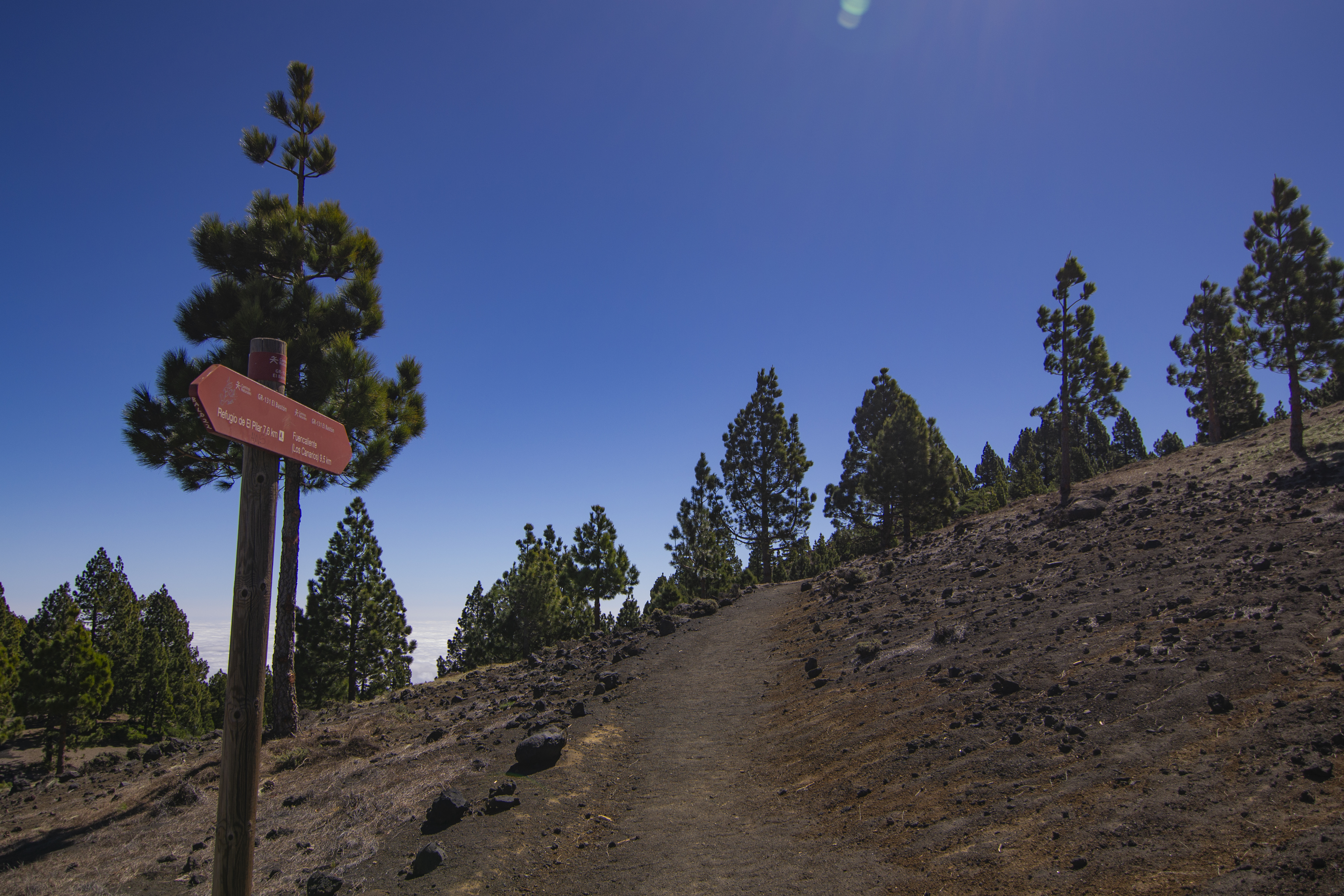
This stage begins at the El Pilar Recreational Area, one of the most popular on the island due to its location, relatively easy access and excellent facilities, including an environmental information centre. It is worth bearing in mind that once you have left the recreational area behind, the next possibility of easily leaving the route or obtaining water is at the Fuente de los Roques rest area, 14 km from the start, so make sure to prepare well for this stage and take plenty of supplies.
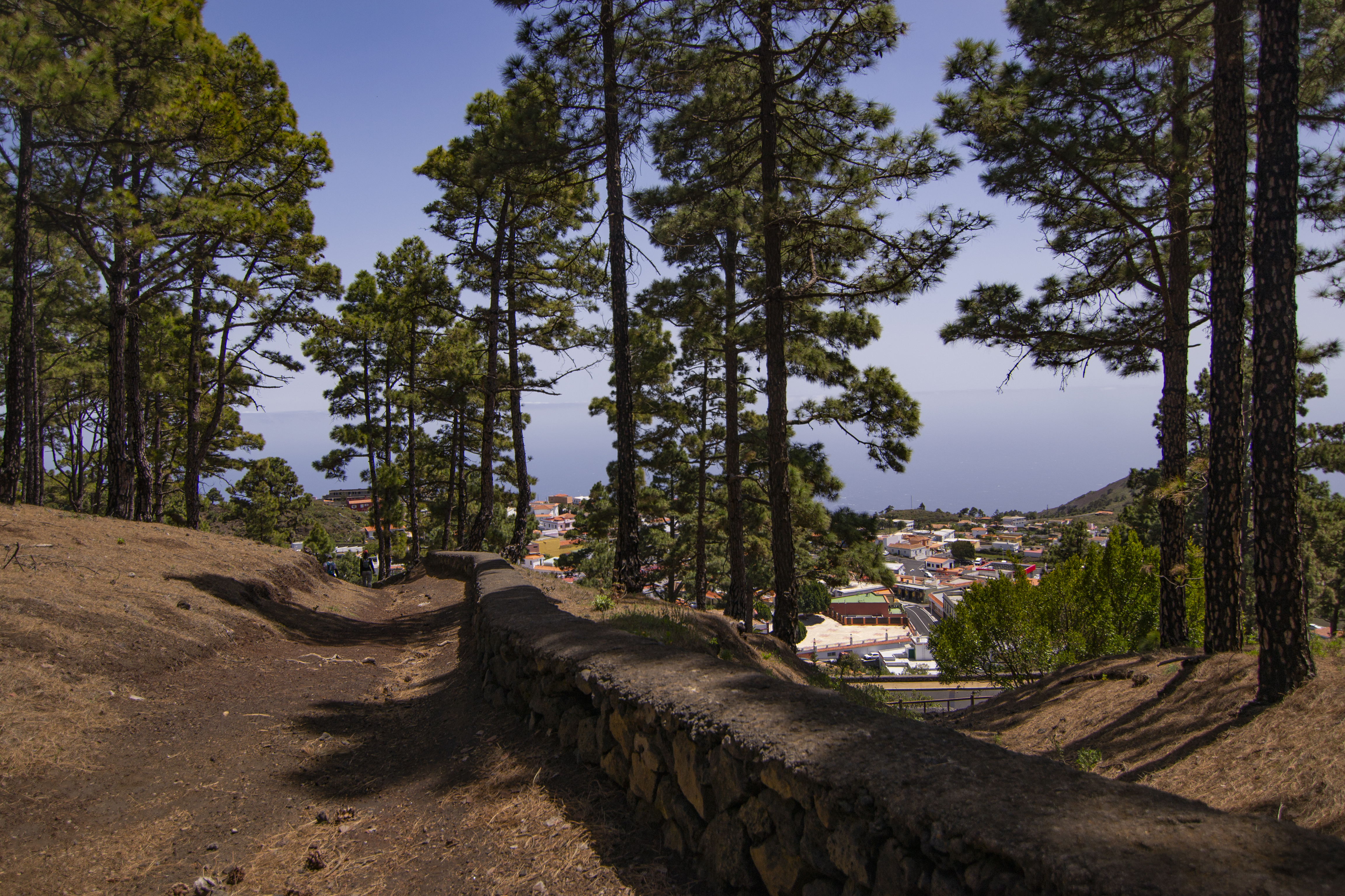
The path immediately enters a pine forest that gains height on the slope of the Birigoyo peak. This first section alternates between a reforestation pine forest and a more mature pine forest in where Canary Island pine (Pinus canariensis) is accompanied by sub-humid shrub species like mountain pine (Adenocarpus foliolosus), amagante (Cystus symphitifolius), broom (Chamecytisus proliferus) and mountain pennyroyal (Bystropogon origanifolius).
As we ascend, there is a small viewpoint with a panoramic table offering spectacular views of the Aridane valley. The path continues around the mountain to the west, arriving at a wider track where it runs briefly before leaving both the track and Birigoyo.

From here, at the start of the ascent to the Hoyo Negro crater, the name Route of the Volcanoes begins to live up to its name. This crater was witness, together with the Peach Tree crater that will be visited later, to the eruption of 1949. During the ascent, the pine forest has become increasingly scarce in favour of a sparse scrub formation characteristic of the lapillis and volcanic sands of recent eruptions, the crespar. Among the species found in this area are the crespa (Plantago webii (an ednemism of the Canary Islands), and palm endemisms such as the palm thyme (Micromeria herpyllomorpha), pajonera grass (Descurainia gilva) and rosalillo Pterocephalus porphyranthus.
During these first few kilometres of the stage, the altitude marks the predominance of a low and resistant scrubland, adapted to the harsh climate conditions of the place, with the red or pink tajinaste (Echium wildpretii) standing out among all the species, which with its spectacular flowers gives colour to one of the typical snapshots of the island of La Palma.
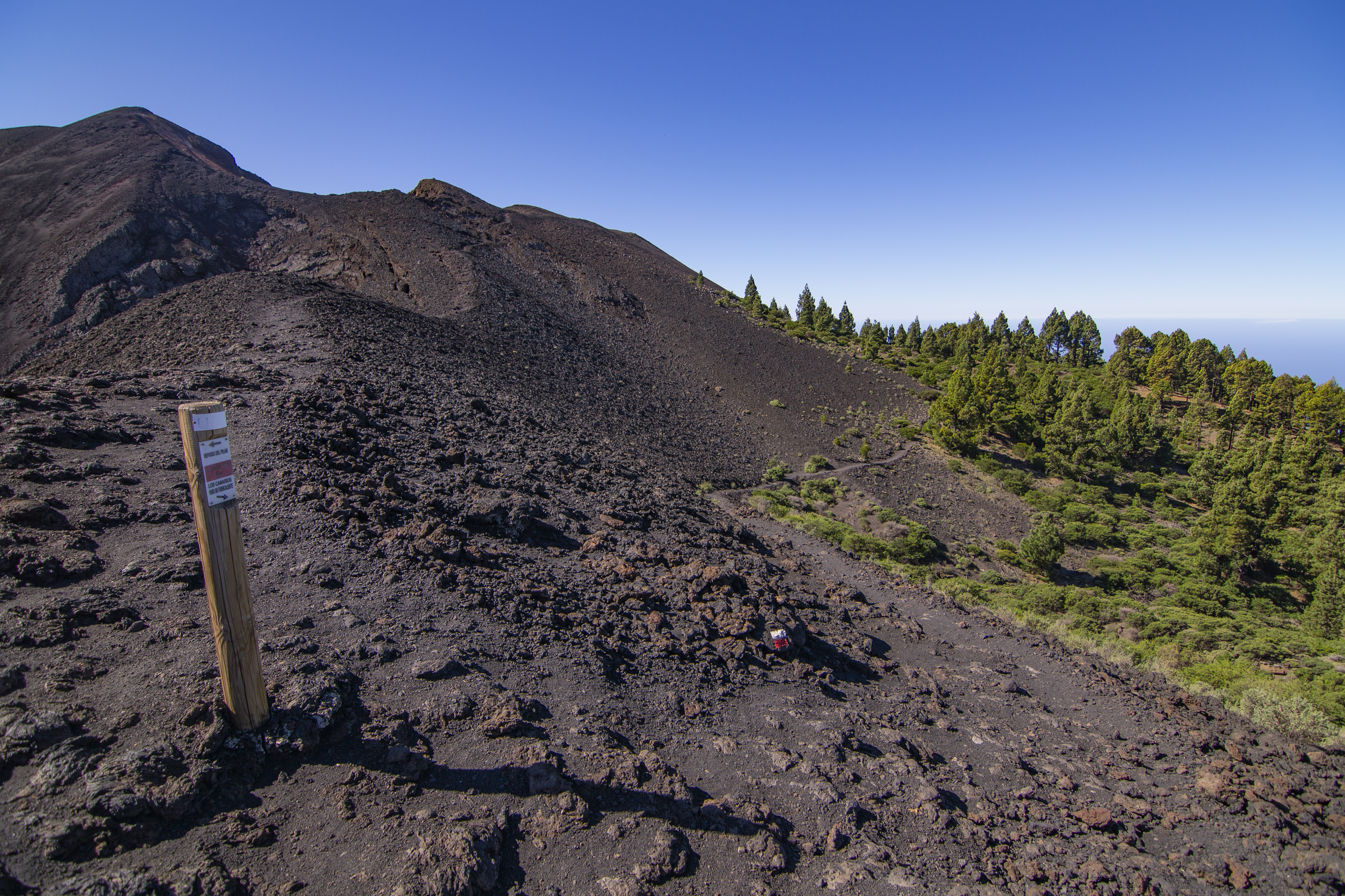
Leaving the peak of Nambroque to the left, the path descends halfway down the slope towards the Malforada lavas, an impressive spot formed by the lava flow of the Duraznero. We then skirt the Fraile mountain to the right and the path reaches its highest point at Las Deseadas, a volcano with two almost twin peaks separated by its crater, representing the highest point reached on this stage.
We then enter a kind of closed valley, where a slight ascent leads to an ancient crater that looks like a closed valley covered with lapilli from the eruption of the El Charco volcano. From this point on, the rest of the stage is an almost continuous descent. The path skirts first the Cabrera mountain, and then the Hoya de la Manteca and the Martín volcano, whose reddish tones stand out against the grey tones of the surroundings. The path skirts these volcanoes on their western side and continues in the direction of Pelada mountain, leaving behind the scrubland landscape to re-enter the pine forest floor.

A path skirts its way around Fire Mountain halfway up. Just before leaving it behind, a detour leads to the recreational area of Fuente de los Roques, where you can refill your water bottle or leave the route if you need to, with this point reachable by car. Back on the route, the path continues its descent through the pine forest. On this slope, with less humidity, the accompanying vegetation has changed to species like the rockrose narrow-leaved cistus (Cistus monspeliensis) or Canary buckthorn (Rhamnus crenulata).
After more than two kilometres of descent through pine trees along a path bordered by rocks, you reach a wide track that connects with the village of Los Canarios. At this point, this stage of the GR 130 intersects with the end of stage 6 and the start of stage 7 of the GR 130. The descending path is resumed, which briefly meets the same track as before and, half a kilometre later, merges onto asphalted track that leads to the sports area of Los Canarios. Before crossing the track, if you walk along it in a westerly direction you can reach a rest area. After crossing, the trail follows a cobbled slope that ends at the foot of the Church of San Antonio Abad. Curiously, the bells of this temple were installed in 1867 with donations from locals who had emigrated to Cuba, next to a bronze statue erected in honour of the hikers who walk the paths of La Palma every day.
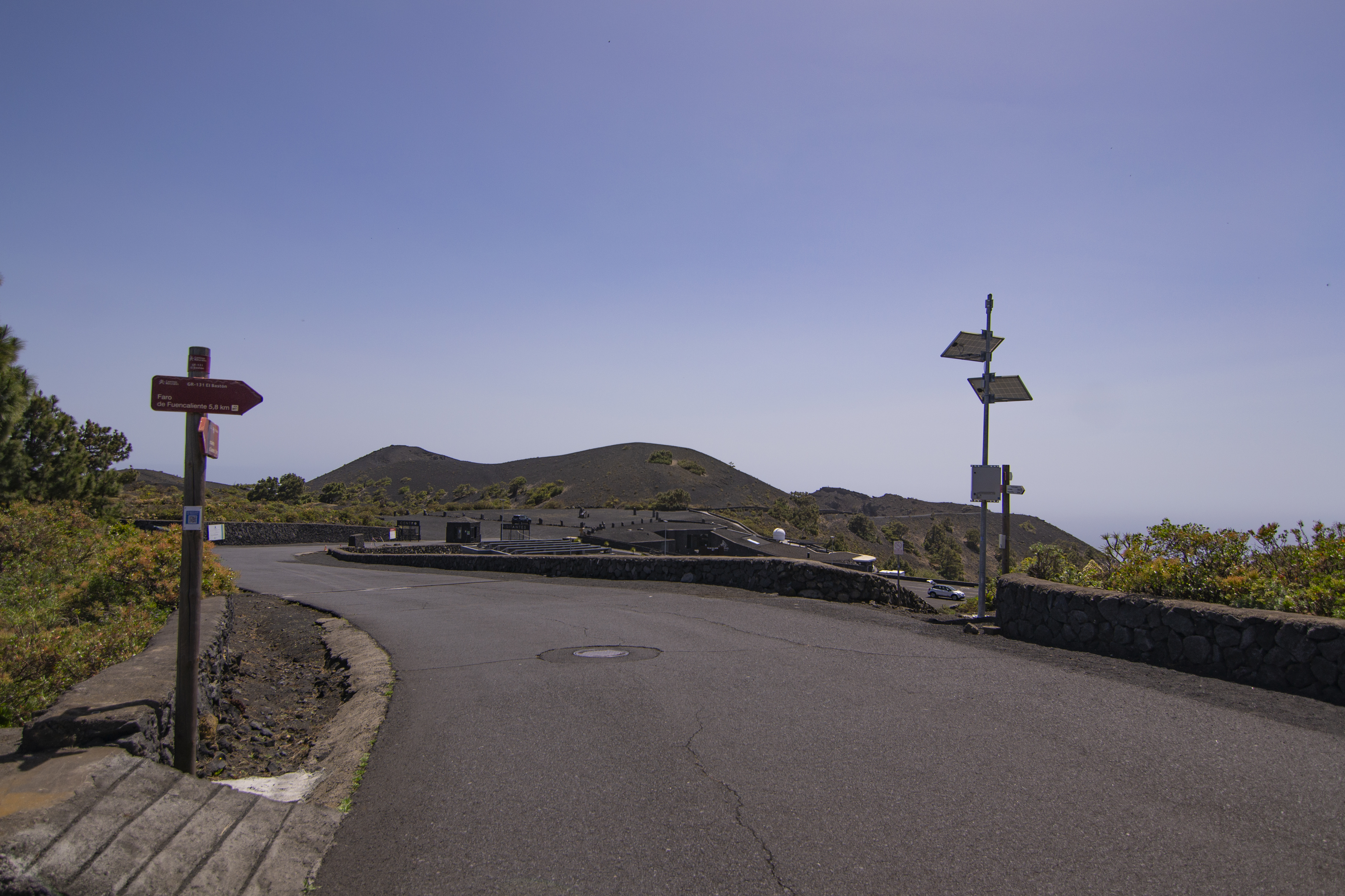
From the square, the descent begins along Calle José Pons, leading to the main road. Only a little further on, before turning right into Calle Emilio Quintana Sánchez, we tale the Las Indias road, LP-209, until it reaches Calle de los Volcanes. After crossing the road again, continue straight on to the San Antonio volcano. At its foot is the Fuencaliente Volcanoes Visitors’ Centre, an interpretation centre on the volcanism of La Palma and the Canary Islands.
The trail takes a path that starts to the right of the visitors' centre and descends to a wide track that skirts the volcano. On the right you can first see Roque de Teneguía, where a series of aboriginal engravings were found, and then the volcano to which it gave its name, and which last erupted in 1971.

The trail then turns almost 180º to head towards the Teneguía volcano. In this area, where the soil hardly allows the growth of Echium breviame or La Palma thyme (Micromeria herpyllomorpha), man has managed to make the most of the land by planting vines, which occupy almost any area that can be cultivated. Half a kilometre before reaching the volcano, the path changes direction again, taking a track in a southerly direction that runs over the lava of the volcano, between the volcanic cone and the Mago mountain.
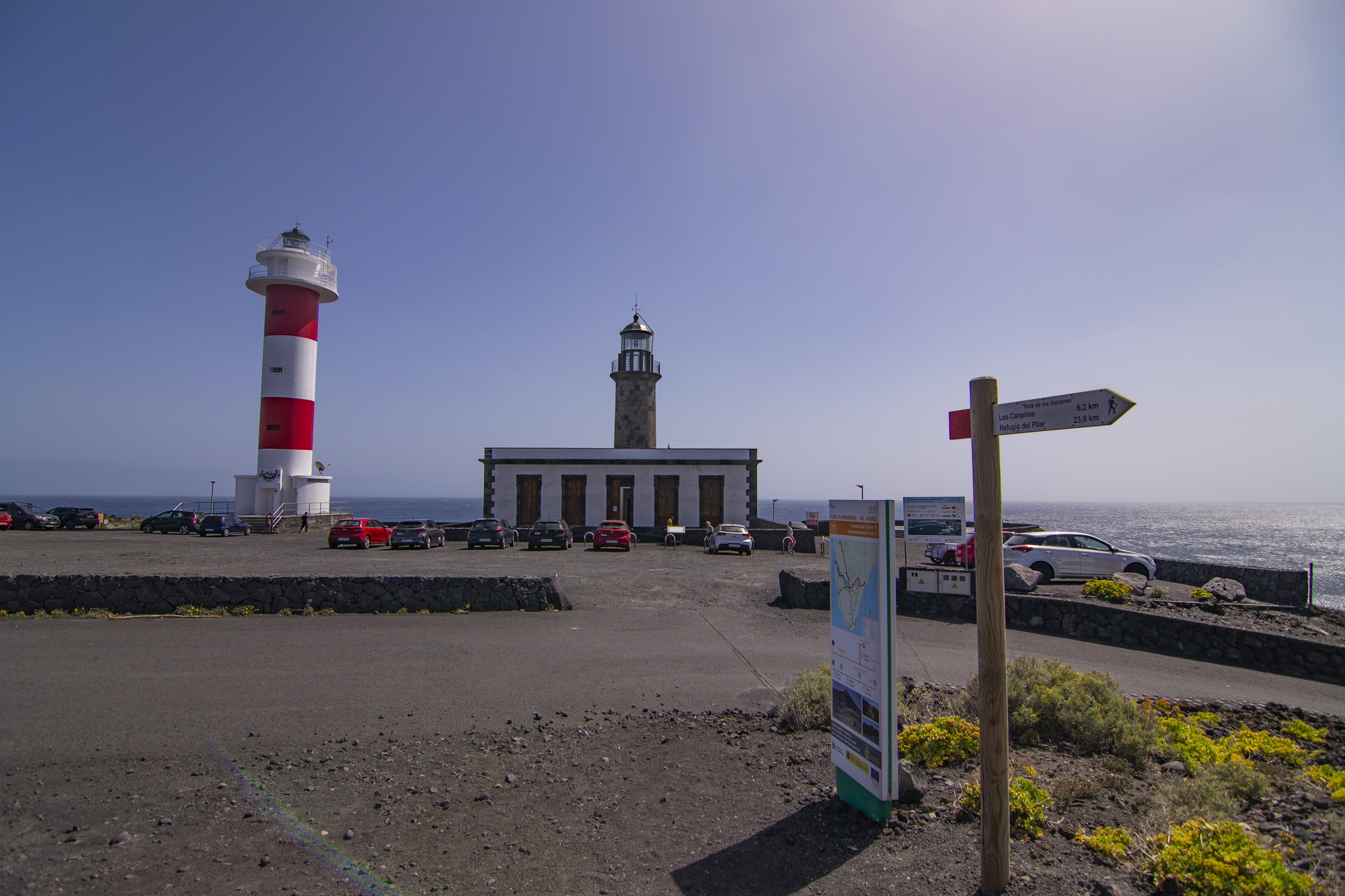
The path meets the LP-207 road, which it crosses on two more occasions as it continues its descent towards the Fuencaliente lighthouse. The lighthouse and salt flats of Fuencaliente, which are visible to the south, are an important landmark on the route. The salt flats have been declared a Site of Scientific Interest, the only ecosystem of this type on La Palma and a meeting point for wading birds. Along the route to the lighthouse, the landscape is dominated by tabaibas (Euphorbia sp.), arreboles, iramas (Schizogyne serícea) or verodes (Kleinia neriifolia), species that have adapted to the volcanic soil and the action of the salty winds.
The path finally ends at the platform where the lighthouses of Fuencaliente are located. The original building was the second lighthouse built on La Palma, in 1899, although it did not enter service until 1904. Apart from the deterioration due to its location, it suffered a lot of damage during the Teneguía eruption, so another one was built next to it in 1983. However, the original lighthouse was restored in 2006 as an interpretation centre for the marine reserve of the island of La Palma.
Although the end point of this trip that began in the port of Tazacorte is the lighthouse, it is worth taking the time to visit the nearby beaches for a well-earned swim if the waves and the weather are suitable.
Sites of interest
Puntos de interés
Culture
Geology
Municipality
Hostel
Vegetation
Profile
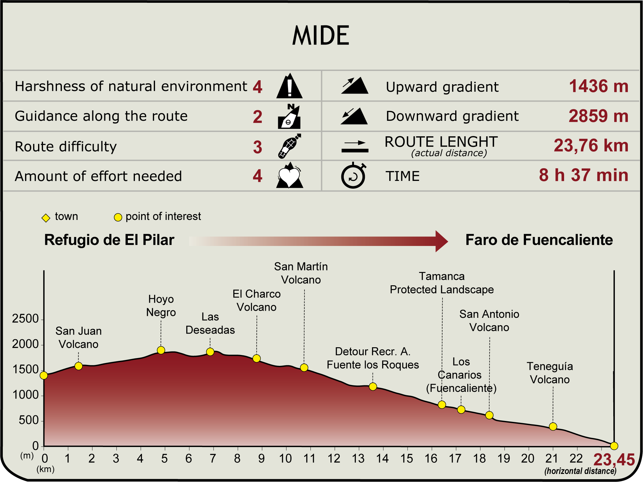
 Harshness of natural environment
- 1. The environment is not risk-free
- 2. There are more than one risk factors
- 3. There are various risk factors
- 4. There are quite a lot of risk factors
- 5. There are many risk factors
 Guidance along the route
- 1. Well defined trails and crossings
- 2. There is a clearly marked trail and signage
- 3. Requires the identification of geographic features and cardinal points
- 4. Requires off-path navigation
- 5. The trail is interrupted by obstacles that have to be gone around
 Route difficulty
- 1. Walking on a flat surface
- 2. Trails with different types of path
- 3. Walking on stepped paths or irregular terrain
- 4. The use of hands or jumping over the terrain is necessary
- 5. The use of hands is required to progress
 Amount of effort needed
- 1. Up to 1 hour of continuous walking
- 2. Between 1 and 3 hours of continuous walking
- 3. Between 3 and 6 hours of continuous walking
- 4. Between 6 and 10 hours of actual walking
- 5. More than 10 hours of continuous walking
(Calculated according to the MIDE criteria for an average excursionist with a light load)
Highlights
Further information
The latest eruptions on La Palma
Cumbre Vieja is one of the two main volcanic areas on the island of La Palma, together with the area of the Taburiente Domain, in the north of the island, and is currently inactive. The Dorsal Domain, in the south of the island, is made up of Cumbre Vieja and Cumbre Nueva, and has been at the centre of the latest eruptions recorded on the island of La Palma. The dates and the name given to the volcano that caused the eruption are listed below:
1470-1492: Montaña Quemada.
1585: Tajuya Volcano.
1646: Martín Volcano.
1677: Fuencaliente Volcano.
1712: El Charco Volcano.
1949: San Juan Volcano (craters of Duraznero, Hoyo Negro and Llano del Banco).
1971: Teneguía Volcano.
2021: Tajogaite.
The craters and volcanoes of almost all of these historic eruptions are visited during the Volcano Route.
Salinas de Fuencaliente
The Fuencaliente salt flats, steeped in a rich family tradition, are a place where craftsmanship and sea salt production converge. This space, characterised by its chromatic contrasts to create an impressive sense of magic, has become an enterprise rooted in the nature of the island, spanning generations.
The legacy of craftsmanship has endured over time even since the eruption of the Teneguía volcano in 1979, which left its mark, paralysing the construction of the salt pans for a year. This link with history and nature has attracted ornithologists, botanists and scientists, culminating in its designation as a Natural Area of Site of Scientific Interest in 1994 (LENAC 12/1994, 19 December).
Since the beginning of its activity in 1967, the Salinas de Fuencaliente have experienced a constant growth, reaching their current extension of 35,000 m2, supported by UNESCO programmes in 1994. This saltworks complex has become a reference point for natural and scenic visits to the island, uniquely fusing historical, cultural, natural, botanical and geological aspects.
Multimedia


Downloads


