

Net of Nature
Trails

Stage 1: Puerto de Tazacorte - Roque de los Muchachos
Description
From the sea to the peaks of La Palma
The first stage of El Bastón is an exciting adventure that leads from Puerto de Tazacorte to Roque de Los Muchachos, the highest peak of La Palma, located at an altitude of 2,426 metres, in the Caldera de Taburiente National Park. This route is not only a physical challenge, but also a journey through the varied landscapes and ecosystems of the island, with breathtaking panoramic views of the Aridane valley and the Caldera.

The route starts at Puerto de Tazacorte, where a sign at the foot of the cliff marks the beginning of the route. From here, the path winds its way to the northeast, ascending through the rocky morphology of the island with a series of strategically placed steps that facilitate the climb to reach the impressive viewpoint of La Punta, 270 m above sea level. From here, you can enjoy a panoramic view of the picturesque southwest coast of the island, as well as the fascinating fajanas formed by the Tajogaite volcano in 2021.
The route continues to rose between agricultural tracks, flanked by characteristic black brick walls that separate the banana plantations. After passing a small farm, the path briefly joins the tarmac path to El Time. After 300 m, the path turns off to the right to face a steep paved slope, flanked by banana trees.
After passing this section, the path turns right again and continues along an unpaved track until it reaches the asphalted path to Miasoles, which we take for some 700 metres. Finally, we reach the Mirador del Mite viewpoint, 594 m above sea level, from where the view is even more extensive. After passing by a nearby restaurant, the path turns slightly to the left to cross the LP-01 and rejoin the Time path, which is paved for only a few metres before going around a house.

A few metres further on, the path reaches a somewhat flatter area that serves as a connection point with stage 5 of the Camino Real por la Costa, from Tijarafe to Los Llanos de Aridane. Here, at 600 m above sea level, impressive views open up to the southeast, revealing the majestic Aridane valley, the Tajogaite lava flows, the Cumbre Vieja ridge and the final sections of the Barranco de las Angustias ravine. To the northwest, the landscape of the middle lands extends, showing how erosion has modelled the ancient lava flow forms of the primitive Cumbre Nueva Volcano. In this section, the environment begins to transform, the coastal ecosystem merging with that of the middle lands, giving way to the first Canarian pines and the working areas, both in use and abandoned.
The path continues uphill for a kilometre and a half on a relatively straight route, crossing fields dominated by vineyards, avocado and, to a lesser extent, banana trees, until it reaches the road to Las Cabezas. This part of the path runs along a farm track with an uneven surface, combining steep and flat areas. The track, with areas of earth and basaltic rocks of different sizes, is flanked by traditional agricultural walls made of volcanic rock. Among these plots, you can see traditional Canarian-style agricultural dwellings, with white-painted volcanic rock walls and black stone skirting boards and corners, as well as brightly painted doors and windows. Before continuing parallel to the road, there is a drinking water fountain and several panels with information on the agricultural uses and traditions of the municipality of Tijarafe. Here, 5.3 km from the start and at an altitude of over 730 m, might be an ideal spot rest and admire the fabulous views of the municipality of Tijarafe, with the ocean as a backdrop beyond the forests of the summits. The perfect place to recharge your batteries before continuing the ascent, while enjoying the natural beauty and rich agricultural heritage that defines this stage.
Having crossed the road, the path returns to the track and continues climbing for two kilometres, gaining more than 300 metres in altitude, exceeding 1,100 metres and reaching the edge of the Caldera de Taburiente, and the Torre del Time and the Hoya Grande viewpoints. From here, you begin to leave behind the views of the Aridane Valley and the depths of the Caldera begin to come into view.

This section is one of the toughest and most fascinating of the entire stage. Its difficulty lies in the steep slope and the irregular relief of the track, made up of large basaltic rocks forming a sort of volcanic road. Its beauty lies in the notable contrast between the agricultural landscapes of the middle lands and the Canary Island pine forests (Pinus canariensis) that dominate the area. Here, not only is the change of landscape visually apparent, but a change in temperature is also felt, somewhat higher due to the increased sun exposure and decreased humidity resulting from the remoteness of the ocean. This floor is one of the richest in biodiversity on the island. In addition to the pines, there are other species such as heather (Erica arborea), Cistus symphytifolius and Adenocarpus viscosus, together with herbaceous species such as grasses and vines, the fruit of agricultural use.
After passing the viewpoint, the path enters a forest track before turning right where it takes a narrow path that leads to the peak of Hoya Grande, at 1,344 metres above sea level. On this route, you may be pleasantly surprised by the terraced vineyards surrounded by a pine forest, as the road winds its way towards the Roque de los Muchachos. For the next two kilometres, the narrow, stony path crosses a dense pine forest and climbs steeply uphill.
A remarkable feature of Canary Island pine is its extraordinary regenerative capacity. This species, endemic to the Canary Islands, can survive fires thanks to its thick bark and its ability to resprout, recovering part of its vegetation within just six months of a fire. Along the route, the path approaches and leaves the ridge of the Caldera, offering, at the highest points, impressive views of the Barranco de Las Angustias ravine and the Bejenado peak, witness to the oldest volcanic history of La Palma.
From 1,800 m above sea level, close to the tenth kilometre of the route, the forest begins to open up, revealing the first examples of high mountain vegetation on La Palma. These plants have adapted to extreme climatic conditions, such as low temperatures and high sun exposure. The landscape, still dominated by pine forests, becomes less dense at such high altitudes, giving way to bushes such as the tajinaste(Echium sp.) and endemic plants such as the blue tajinaste (Echium gentianoides) or the summit bencomia (Bencomia exstipulata), which stand out for their resistance to wind and cold, with compact forms and small leaves.

After skirting the cliffs of Somada Alta at about 1,890 m above sea level, the path sneaks around the Hoya del Estrabito, a depression from the edge of which the peaks of the Caldera and the beginning of the Cumbre Vieja Ridge can be clearly seen. It also offers a brief moment of respite as the path flattens out slightly for a few metres. Continuing for just over another kilometre, the first stage of the Bastón gradually leaves the forest behind and arrives at the Pinos Gachos, at an altitude of 2,100 metres above sea level. An idyllic spot from where you can make out, looking to the right, the Caldera, Roque Idafe, Cumbrecilla, Pico Bejenado, Dorsal del Cumbre Vieja, Valle de Aridane and the lava flow forms left by the recent Tajogaite volcano.
A remarkable feature of Canary Island pine is its extraordinary regenerative capacity. This species, endemic to the Canary Islands, can survive fires thanks to its thick bark and its ability to resprout, recovering part of its vegetation within just six months of a fire. Along the route, the path approaches and leaves the ridge of the Caldera, offering, at the highest points, impressive views of theBarranco de Las Angustias ravine and the Bejenado peak, witness to the oldest volcanic history of La Palma. From an altitude of 1800 m, close to the tenth kilometre of the route, the forest begins to open up, revealing the first examples of high mountain vegetation on La Palma. These plants have adapted to extreme climatic conditions, such as low temperatures and high sun exposure. The landscape, still dominated by pine forests, becomes less dense at such high altitudes, giving way to bushes such as the Echium sp. and endemic plants like Echium gentianoides or Bencomia exstipulata on the summit, which stand out for their resistance to wind and cold, with compact forms and small leaves.
After skirting the cliffs of Somada Alta at about 1,890 m sea level, the path sneaks around the Hoya del Estrabito, a depression from the edge of which the peaks of the Caldera and the beginning of the Cumbre Vieja Ridge can be clearly seen. It also offers a brief moment of respite as the path flattens out slightly for a few metres. Continuing for just over a kilometre, the first stage of the Bastón gradually leaves the forest and arrives at the Pinos Gachos, at 2,100 m above sea level. An idyllic spot from where you can make out, looking to the right, the Caldera, Roque Idafe, Cumbrecilla, Pico Bejenado, Dorsal del Cumbre Vieja, Valle de Aridane and the lava flow forms left by the recent Tajogaite volcano.
Puntos de interés
Information
Municipality
Orography
Hostel
Profile
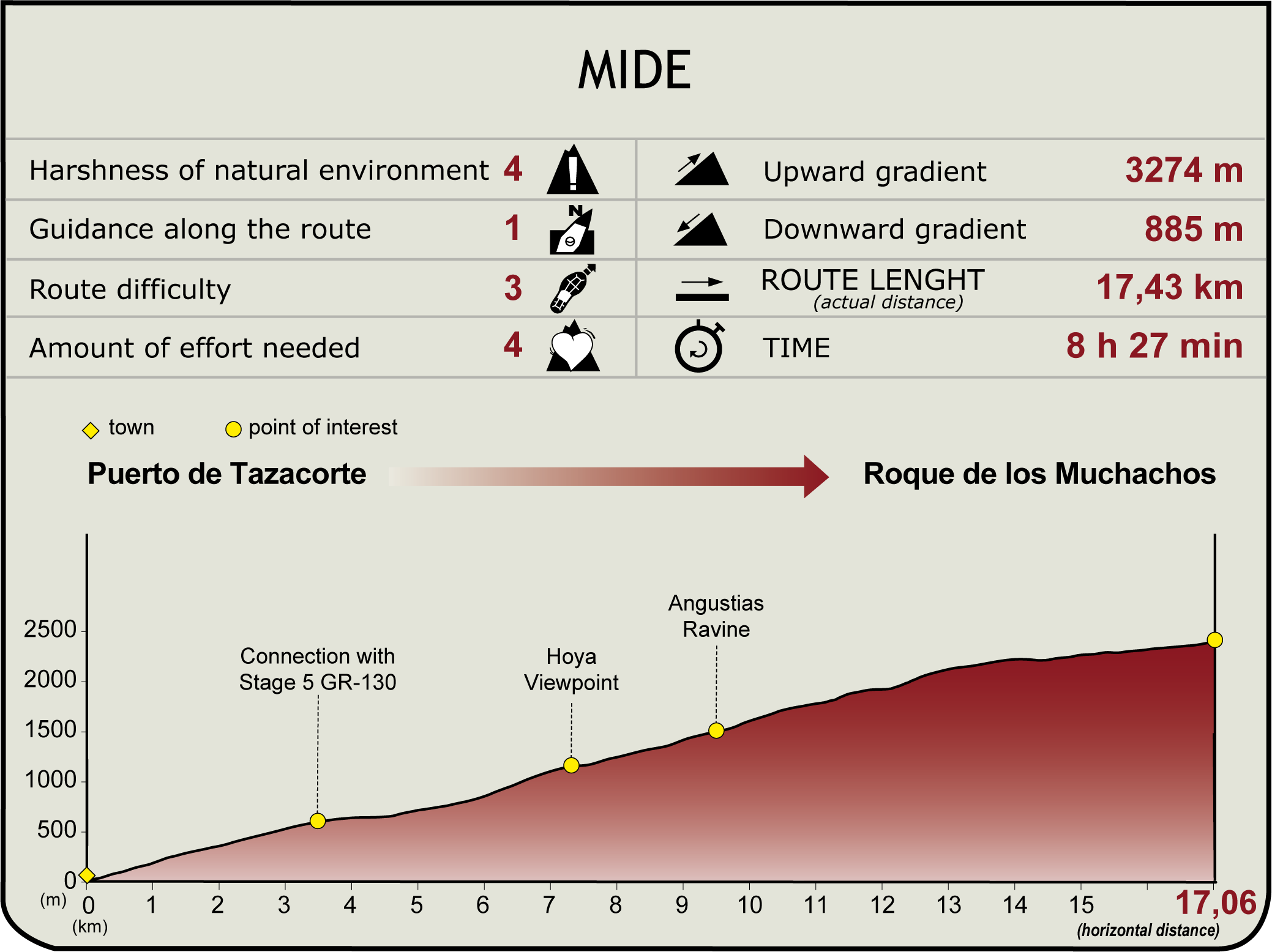
 Harshness of natural environment
- 1. The environment is not risk-free
- 2. There are more than one risk factors
- 3. There are various risk factors
- 4. There are quite a lot of risk factors
- 5. There are many risk factors
 Guidance along the route
- 1. Well defined trails and crossings
- 2. There is a clearly marked trail and signage
- 3. Requires the identification of geographic features and cardinal points
- 4. Requires off-path navigation
- 5. The trail is interrupted by obstacles that have to be gone around
 Route difficulty
- 1. Walking on a flat surface
- 2. Trails with different types of path
- 3. Walking on stepped paths or irregular terrain
- 4. The use of hands or jumping over the terrain is necessary
- 5. The use of hands is required to progress
 Amount of effort needed
- 1. Up to 1 hour of continuous walking
- 2. Between 1 and 3 hours of continuous walking
- 3. Between 3 and 6 hours of continuous walking
- 4. Between 6 and 10 hours of actual walking
- 5. More than 10 hours of continuous walking
(Calculated according to the MIDE criteria for an average excursionist with a light load)
Highlights
Additional Information
Roque de los Muchachos Astronomical Observatory
La Palma’s Roque de los Muchachos Observatory is a prestigious astronomical centre. Situated at an altitude of approximately 2,423 metres above sea level, its location offers optimal atmospheric conditions for astronomical observation, benefiting from dark skies and low light pollution, which guarantee an exceptional environment for the study of the cosmos.
This complex houses a variety of observatories and telescopes, both optical and radio astronomical, operated by various international institutions. These include the Gran Telescopio Canarias (GTC), one of the most imposing structures with a primary mirror of 10.4 metres in diameter, and the Telescopio Nazionale Galileo (TNG), with an aperture of 3.58 metres.
Scientific institutions and space agencies from all over the world take advantage of the facilities of the Roque de los Muchachos Observatory to carry out research and observations of astronomical relevance. Due to the sensitivity of the instruments, access to the observatory is usually restricted and reserved for authorised personnel and scientists. However, some observatories do organise public visits and outreach activities.
Over the years, the Observatory has played a crucial role in contributing significantly to discoveries and advances in astronomical research, covering areas such as astrophysics, cosmology and space astronomy.
Barranco de las Angustias ravine
The Barranco de Las Angustias ravine, in La Palma, is a protected area of great geological and environmental importance. Located in the west of the island, it crosses several municipalities and forms the boundary and drainage area of La Caldera de Taburiente.
Its geology includes ancient basal materials and unique rock formations, as well as the impressive Cascada de Colores waterfall. This ravine is home to a remarkable biodiversity, with plant species such as the Canary Island pine, La Palma lavender and the Echium wildpretii, as well as animal species like the La Palma giant lizard and the laurel pigeon. It holds important historical and cultural value linked to the culture and traditions of the Benahoaritas, who took advantage of their natural resources, especially water resources.
Multimedia


Downloads

GPS Downloads


