

Net of Nature
Trails

Stage 10: Punta Nati - Ciutadella
Description
Strolling along the northwest cliffs, watching seagulls fly by
From the area around Punta Nati, the road heads towards the town of Ciudadella. The first route runs along the rocky ground of the north-western cliffs. This is a landscape known as Menorca Seca, the dry Menorca. These formations, such as the Costa Nord de Ciutadella SCI and SPA, are included in the Natura 2000 Network. Afterwards, the route continues through the streets of the residential complexes and ends at the old port of the city.

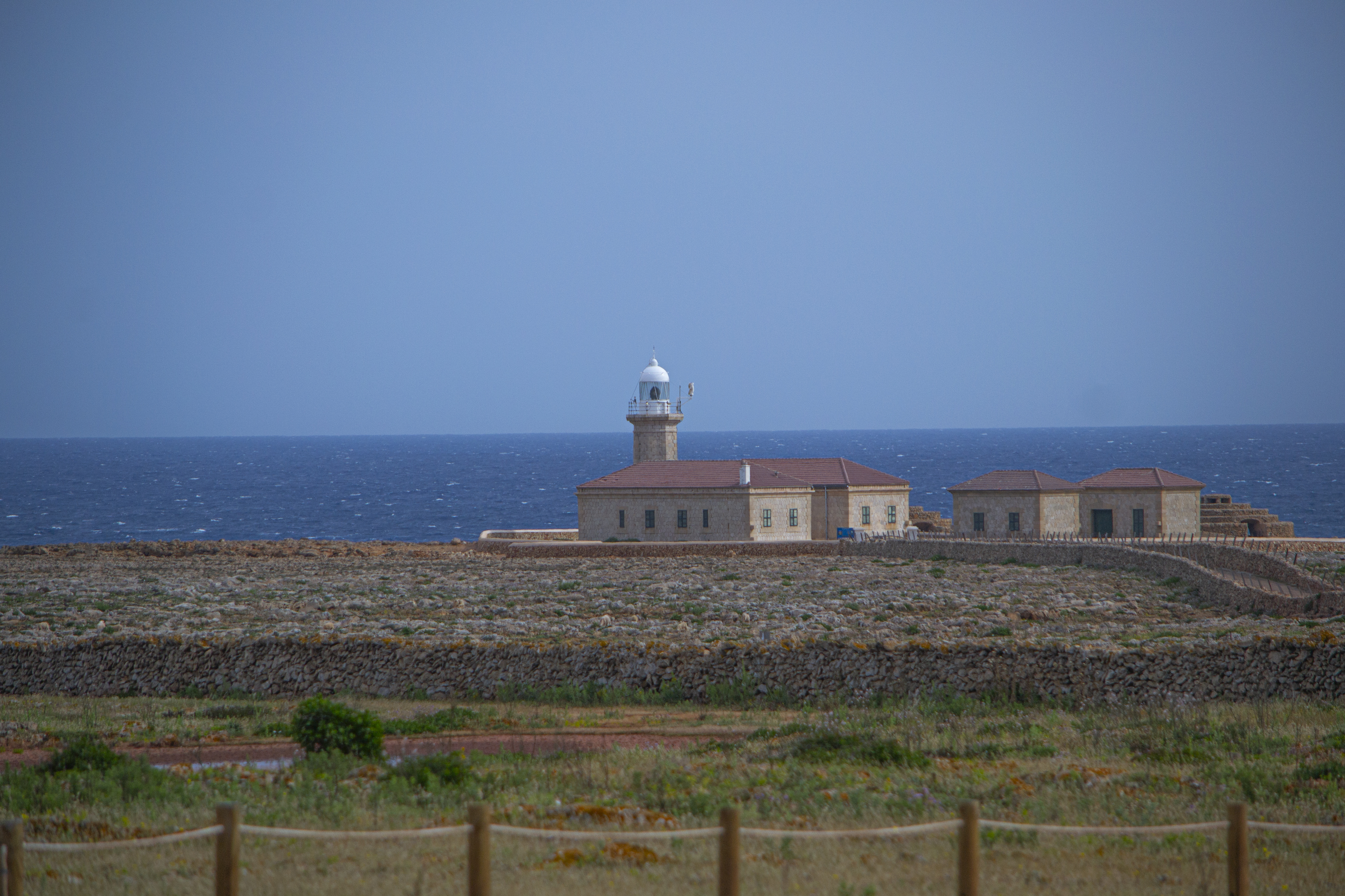
This tenth stage of the Camí de Cavalls Nature Trail begins next to the access road to the Punta Nati lighthouse, about 900 m from the lighthouse to the north and 300 m from the car park to the south. Your starting point will be one of the famous Menorcan gates, after which the trail leads into the type of landscape that will dominate the first half of this stage.
The route winds along rocky ground, with the cliffs and the sea on the right, surrounded by grassy pastures where it is easy to spot sheep feeding. In addition to grass, the only plants are those specially adapted to brave the salty winds: sea fennel (Crithmum maritimum), Provence wormwood (Artemisia gallica), Perennial saltwort (Sarcocornia fruticosa) or sea-lavender species (Limonium spp.), as well as caper bushes(Capparis spinosa), which stand out because they are the tallest.

Despite the stony surface of the road and the fact that the path is a little rough at times, this first section is relatively easy, as there are hardly any slopes.
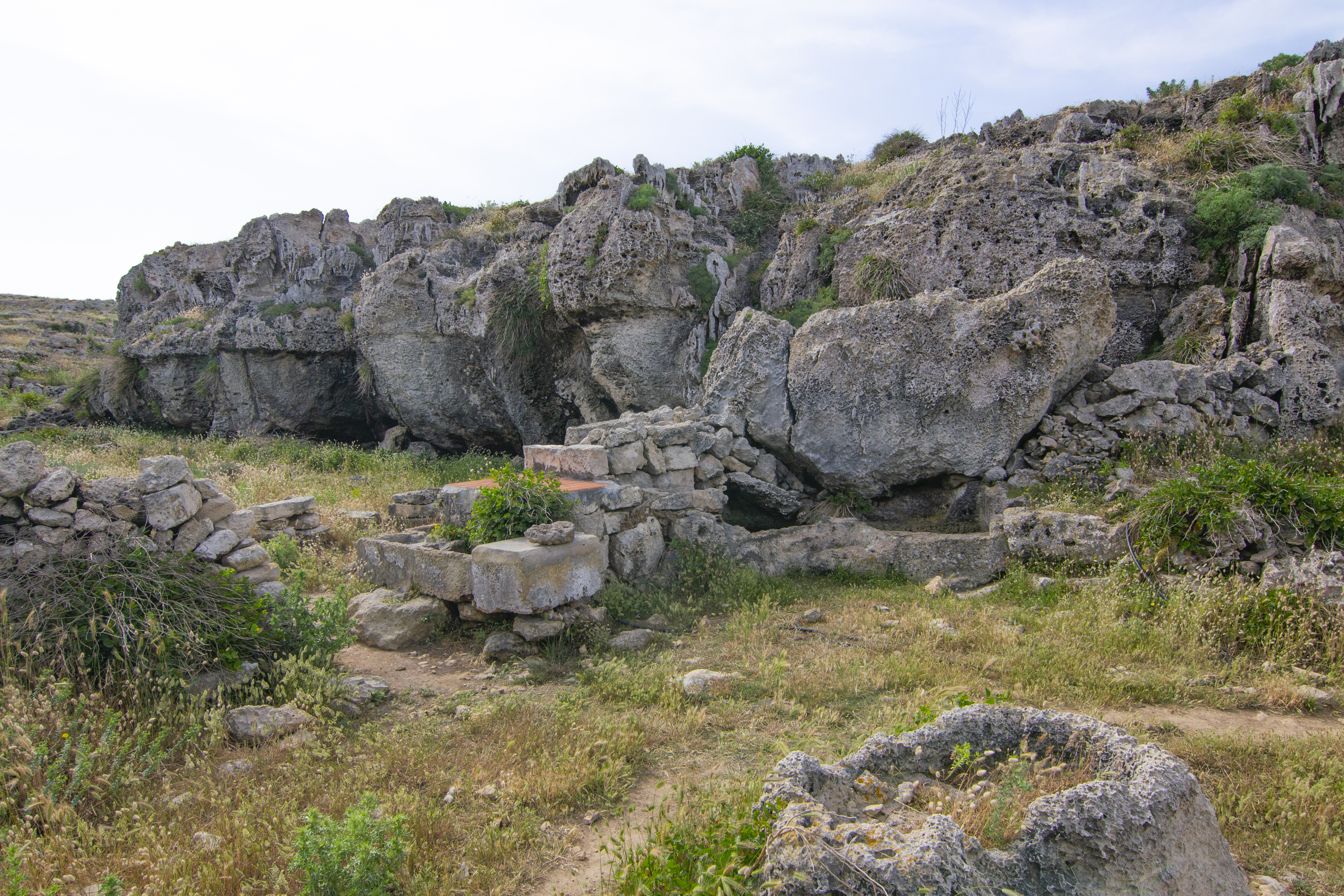
Another of the characteristic elements of this stage, which you will see for a long stretch, are the stone walls to the left of the path, on which the characteristic Menorcan huts or barraques stand out. On the other side is a wide plain covered with llocs, the popular name for agricultural estates in Menorca. Precisely, after the first 2 km, the path comes across one of these huts and, once it has been left behind, begins a descent towards a ravine next to which there is an old livestock enclosure, with a well and water troughs dug out of the rock. It will not be the only one you see: after going up the ravine and covering another half kilometre, you will reach another of these characteristic huts.
The path climbs slightly before reaching Sa Falconera, a spectacular viewpoint overlooking the Mediterranean from where there are magnificent views of the cliffs that have been traversed and the small headlands populated by seagulls. After leaving Sa Falconera, a somewhat steep descent begins, so extreme caution is recommended, which goes around some rocks on which there are the remains of some old military installations: some coastal batteries and the buildings of Es Semáfor, an optical telegraph.
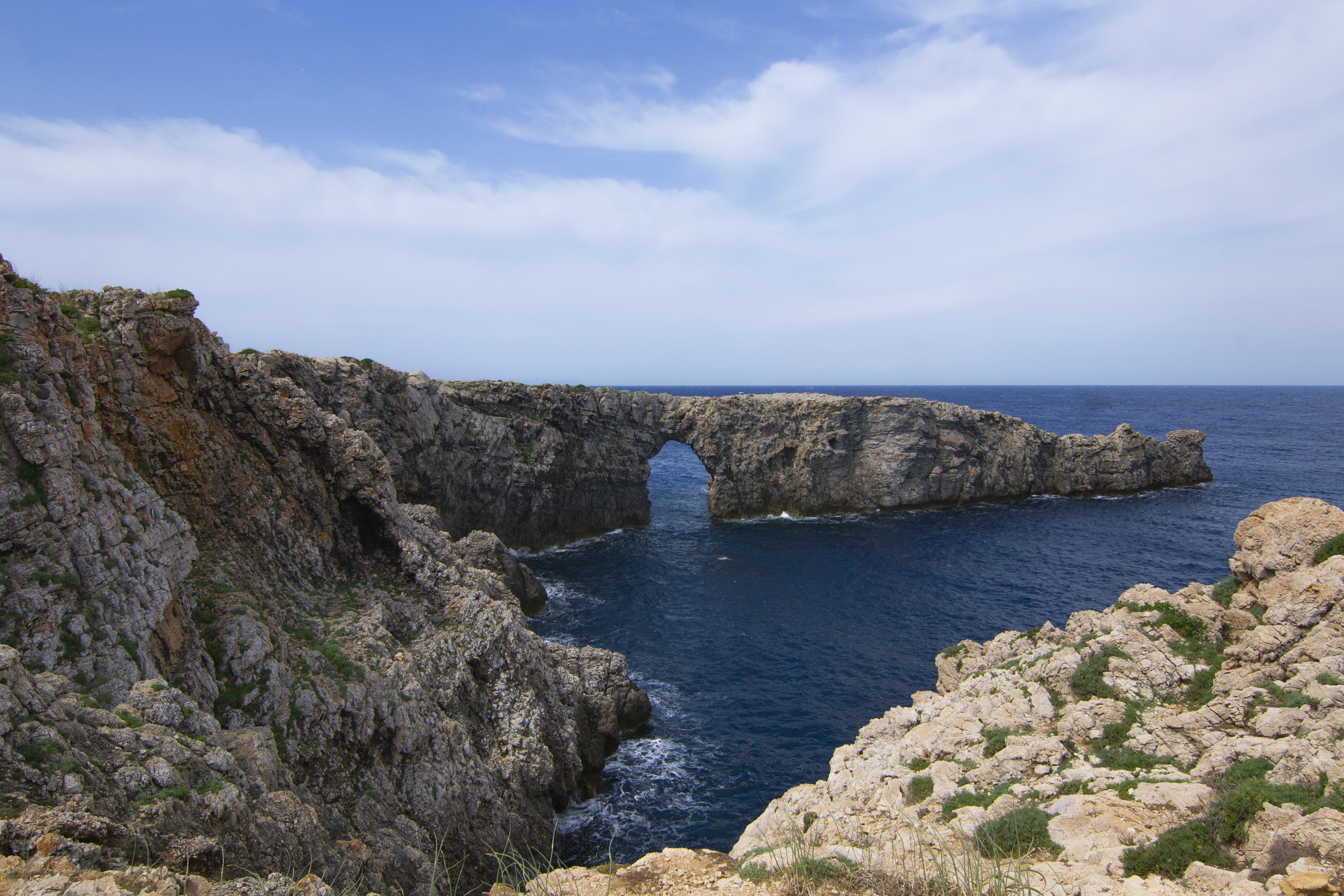
Shortly after, you reach an asphalted road, which gives access to the Ciutadella Nord WWTP, along which you will continue for 300 m, leaving it on the right to continue again along the path. The trail goes towards the coast again, passing through the ravine that leads to Cigonya Cove and then arriving at one of the most famous sights in this part of the island, the formation known as Pont d'en Gil: a spectacular natural rock arch, carved over the centuries by sea action.

Continuing along the stage, after 300 m you reach Cales en Blanes/Los Delfines, a residential complex belonging to the municipal district of Ciutadella de Menorca. Although an information board indicates the way, keep an eye on the Nature Trail signposting and pay close attention when crossing the road. The route crosses Cala en Blanes along Avinguda des Pont d'En Gil and then along avinguda Calespiques until it reaches a roundabout where it takes avinguda dels Delfines.
This street changes its name when it passes under an arch that marks the end of this residential complex and the beginning of the next one, Torre del Ram, and is now called Avinguda Simón d'Olivar. Continue along this road until you reach the car-free access to the beach of Cala En Blanes.
If you want to know more about Menorcan history, take a momentary detour to visit the Torre del Ram hypogeum, an underground burial site used during the Naviforme period.
Go around this small cove, admiring its fine sand and clear waters, and, leaving it on its western shore, walk along the rocks and then up some steps that lead to the Camí de Sa Farola. It is a sort of promenade on the cliff with a pedestrian pavement and cycle lane, and at some points benches facing the sea have been installed and can be used as lookout points. After a little more than 1 km along this street, the path leads to the lighthouse of Ciudadella or Sa Farola, which gives its name to the promenade.

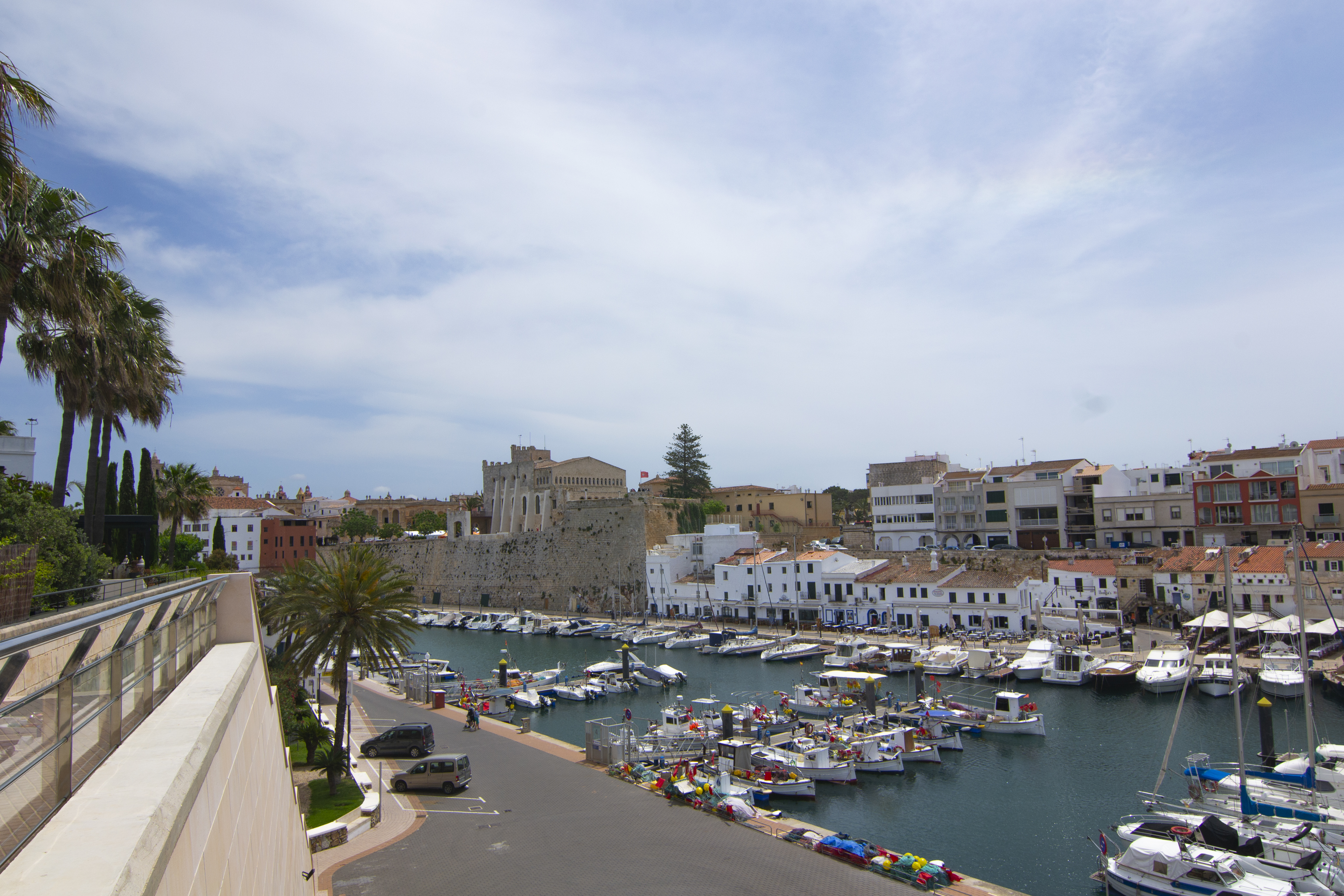
From this point it is already possible to see, on the other side of the inlet, part of the city of Ciutadella. IN the skyline, the Sant Nicolau fort stands out: this is a defensive fortress that guarded the entrance to the southern end of the city's port.
Leaving the lighthouse behind and passing by the chapel of the Assumption of Sa Farola, you will return to the Camí de Sa Farola path, which surrounds the picturesque Des Frares Coves and then foes through a pine patch. The street no longer has pavements so, although there is plenty of space on either side of the road for safe walking, attention should be paid to cars passing by. Now you are squarely on one of the sides of the port of Ciutadella.
The pine grove opens up at Cala en Busquets, a small cove with a very popular pier, where the pavement is once again restored. There are only 400 metres more to go to reach the end of the stage, in a large car park located above the port of Ciutadella. From the edge of the car park there are spectacular views of Ciutadella, the port and the old town, and the skyline formed by the walls, the town hall building and the cathedral stand out from the rest.
Links of interest
Profile

 Harshness of natural environment
- 1. The environment is not risk-free
- 2. There are more than one risk factors
- 3. There are various risk factors
- 4. There are quite a lot of risk factors
- 5. There are many risk factors
 Guidance along the route
- 1. Well defined trails and crossings
- 2. There is a clearly marked trail and signage
- 3. Requires the identification of geographic features and cardinal points
- 4. Requires off-path navigation
- 5. The trail is interrupted by obstacles that have to be gone around
 Route difficulty
- 1. Walking on a flat surface
- 2. Trails with different types of path
- 3. Walking on stepped paths or irregular terrain
- 4. The use of hands or jumping over the terrain is necessary
- 5. The use of hands is required to progress
 Amount of effort needed
- 1. Up to 1 hour of continuous walking
- 2. Between 1 and 3 hours of continuous walking
- 3. Between 3 and 6 hours of continuous walking
- 4. Between 6 and 10 hours of actual walking
- 5. More than 10 hours of continuous walking
(Calculated according to the MIDE criteria for an average excursionist with a light load)
Highlights
Pont d'En Gil
The action of sea erosion on the cliffs to the northwest of Ciutadella have carved this unique natural formation in the form of a rock bridge that has become quite a popular destination. To enjoy the view, the best panoramic views are from the opposite side of the inlet, although it is also possible to walk over the cliff itself and even cross over the bridge.The dimensions of the arch allow small and medium-sized vessels to pass under it, which has beco
me a popular among the companies that make tourist sea trips in the area.
Pont d'en Gil also attracts numerous divers seeking access to the cave of Sa Cigonya. This cave extends some 300 m below the cliffs and can only be accessed from underwater. This activity should be done with appropriate equipment and an experienced guide.
Torre del Ram Hypogeum
Hypogea (from the Greek hypógaion, underground chamber) are artificial underground galleries or rooms used as tombs. In Menorca they are located mainly in the west of the island.
The Torre del Ram, located in the Cala en Blames residential complex, to the east of Ciutadella, is a collective tomb from the Bronze Age (1600-1200 BC). It consists of a rectangular chamber about 9 m long, with a bench running around the perimeter, that is accessed through a stepped corridor.
This underground construction can be accessed though a chimney that leads to a flight of stairs.
Unfortunately, there is not much information about the people who were buried here or the grave goods, as this building was emptied and has even been reused as a livestock shelter by shepherds. However, on the interior walls of the hypogeum, schematic engravings representing various figures were discovered, some of which seem to represent boats. These engravings have not been dated with certainty.
This infrastructure is one of the 32 monuments of Talaiotic Menorca that have been inscribed by UNESCO on the World Heritage List.
Multimedia


Downloads

GPS Downloads


