
Net of Nature
Trails

Stage 9: Trespaderne - Quintana Martín Galíndez
Description
Entering the Tobalina Valley
At Trespaderne, the Ebro Nature Trail begins its route through the Tobalina Valley. As far as Cillaperlata, which is located under a rocky crag and beside a backwater of the Ebro, it runs along the left bank. It later changes banks to reach the craggy settlement of Frías, which has preserved all its medieval essence in houses perched on the rock and hanging from the ancient walls. Over its fortified bridge, you cross the river again and then a gorge where a botanical route has been created to reach Montejo de San Miguel, an example of the district’s traditional scattered urban development, and finally Quintana Martín Galíndez, the capital of the valley.
At Trespaderne, on the banks of the river Nela, there is a recreational area beside a lane on the left bank leading to the bridge over the Ebro. After crossing this infrastructure, the path heads straight on along a path among fields. On the right is the mouth where the Nela empties into the Ebro, an island of ash trees which is being converted into woodland.
Little by little, the Castrillo road separates from the river and skirts the peak of the same name, at an altitude of 584 m. The route runs through a restored pine forest, combined with gall oaks and deciduous forests in the surrounding hills.
Shortly afterwards, travellers will reach Cillaperlata along an asphalted road beside the bridge and the dam where the Central de Quintana canal begins.

This beautiful village is under a rocky crag in a backwater of the Ebro. It has the parish church of Nuestra Señora de Covadonga, which houses an ancient carving of the Virgin, a copy of an Asturian image dating from before the 12th century. As you pass through the village you can see its curious mansions, as well as two hermit caves that are worthy of mention.
A track heads southeast from the washing place, where this stage merges with the end of the next stage. The route continues straight through a valley until it reaches the Cucharera pass, not before crossing the Cantarillos stream and the Peña de la Dehesa mountain. It then descends to Quintanaseca, where the Romanesque San Martín church and its emblazoned mansions stand out.
The route continues on the road that leads to the BU-520 and heads up to Frías, before continuing straight on to the car park, from where you can visit the village, whose history dates can be traced to the 9th century. From here, a slight descent will take you to the village’s magnificent medieval bridge.

Travellers must then stand on the left side of the bridge, from where a path runs parallel to the river. Among riverside forest, black poplars, kermes oak and occasional patches of boxwood, the route gradually leads away from Frías, ascending to a strip of meadows where a lane turns left. The journey then continues to a country house, where the route leads through the upper field and the grove by the river to a signposted path, close to the Ebro and bounded by the rocky slope of San Miguel hill, crowned by the Romanesque hermitage bearing the same name.
The road continues along a gorge, through a wooded area that passes through a botanical route with species identified by plaques: Lombardy poplar, black poplar, ash and so on, until the path comes to a track under the Montejo de Cebas weir, which was built in the late 19th century.
The route continues on the left uphill to Montejo de San Miguel, a municipality with a scattered layout featuring traditional houses immersed in lush vegetation. An ideal place for walks along the routes in the area. Here the stage leaves the Montes Obarenes-San Zadornil Natural Park behind.
The route continues along the Calle Mayor to a rest area where you will find stairs leading down to the Montejo de Cebas road. Here travellers should continue straight on, following a riverside path among fields on the right; it crosses the river and the natural area of the Vega de San Sebastián. This is where you must cross the San Antonio stream before coming out onto the Quintana road.
Shortly afterwards, after scarcely 500 metres, the path takes a detour on the right leading to the bridge over the Iberduero power station’s canal, which gives access to the town, the capital, administrative and service centre of Valle de Tobalina. Dating to the 11th century, it features the Gothic church of Santo Tomás Apóstol (16th and 18th centuries), the medieval Salazar family tower (11th century), and San Roque hermitage.
Sites of interest
Puntos de interés
Culture
Hydrography
Infrastructure
Municipality
Profile

 Harshness of natural environment
- 1. The environment is not risk-free
- 2. There are more than one risk factors
- 3. There are various risk factors
- 4. There are quite a lot of risk factors
- 5. There are many risk factors
 Guidance along the route
- 1. Well defined trails and crossings
- 2. There is a clearly marked trail and signage
- 3. Requires the identification of geographic features and cardinal points
- 4. Requires off-path navigation
- 5. The trail is interrupted by obstacles that have to be gone around
 Route difficulty
- 1. Walking on a flat surface
- 2. Trails with different types of path
- 3. Walking on stepped paths or irregular terrain
- 4. The use of hands or jumping over the terrain is necessary
- 5. The use of hands is required to progress
 Amount of effort needed
- 1. Up to 1 hour of continuous walking
- 2. Between 1 and 3 hours of continuous walking
- 3. Between 3 and 6 hours of continuous walking
- 4. Between 6 and 10 hours of actual walking
- 5. More than 10 hours of continuous walking
(Calculated according to the MIDE criteria for an average excursionist with a light load)
Highlights
Further information
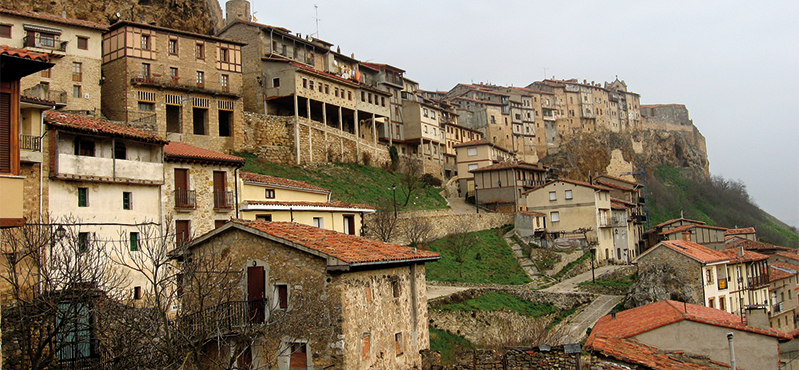
The Art of Frías
The neighbourhoods of La Muela, San Vitores, San Pedro and San Francisco enclose an array of row houses perched on a rock outcrop, which form steep, staggered streets or hang over the sentry walks on the ramparts. Frías was awarded the first prize in the 1976 Provincial Beautification Contest, owing to its typical solarium-galleries and the use of tuff and wood in its buildings. It also home to the Castle of Velasco (12th C.), the church of San Vicente; the Wall of La Muela (13th C.), a medieval bridge (14th C.); the convent of San Francisco (14th C.), the church of San Vitores (12th-14th C.), and the convent of Santa María de Vadillo and its flour mills.
Multimedia


Downloads

GPS Downloads


