Net of Natural
Trails

Stage 28.1: Pina de Ebro - Gelsa
Description
- - - - - - - -
¡AVISO IMPORTANTE!
CON MOTIVO DE LAS OBRAS DE CONCENTRACIÓN PARCELARIA QUE SE ESTÁN LLEVANDO A CABO EN EL TÉRMINO MUNICIPAL DE GELSA AJENAS AL PROGRAMA DE CAMINOS NATURALES, ESTA ETAPA PUEDE PRESENTAR CORTES AL PASO DE PEATONES Y CICLISTAS
SE AVISARÁ OPORTÚNAMENTE DE LOS CAMBIOS QUE PUDIERA HABER EN ESTA SITUACIÓN
- - - - - - - -
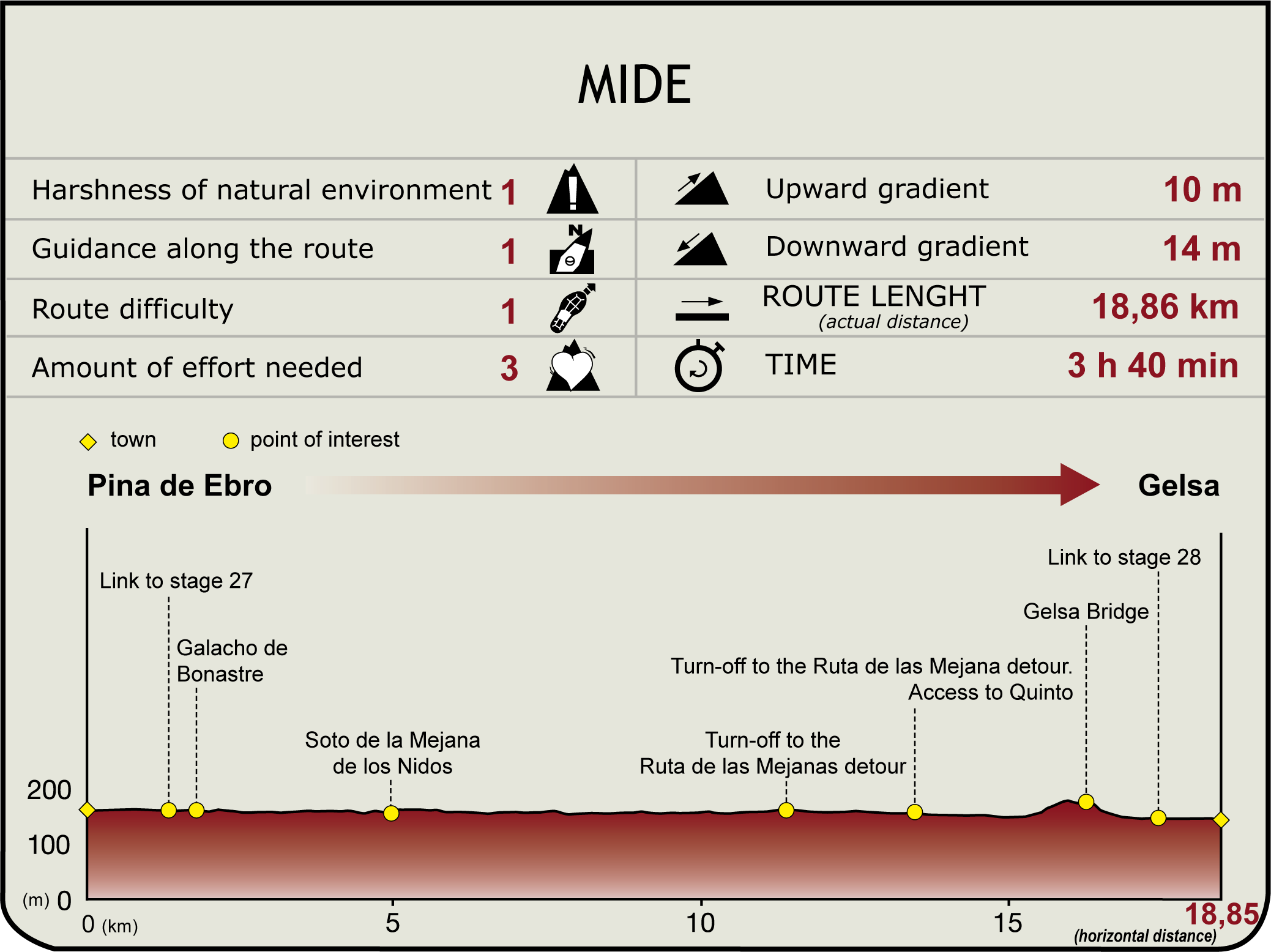
The route heads north, leaving Pina de Ebro behind (160 m) via a riverside track, until it reaches the A-1107, where it turns left onto Pina Bridge.
About 300 m from the opposite side of the bridge, the trail leaves the paved road to turn left onto a dirt track, opposite the farm road coming from El Burgo de Ebro (Section 27), to continue along the River Ebro. The road winds through crop fields, strictly following the course of the river along the old bed of Bonastre sedimented meander, still dammed today. At an intersection situated very close to the river, near a large pine tree, the route turns left and continues parallel to a strip of white poplars. Immediately after, it turns onto a track to the left that ventures into Mejana de los Nidos grove (4.9 km, 1hr). The Nature Trail heads down a track to the right, runs along the riverside for a short stretch, then, past a shed situated at an intersection of irrigation ditches, skirts around Arenales grove, a fenced area with a large island near the opposite shore, to continue through orchards.
The road, lined yet again with large riparian poplars, follows the bend in the river that shapes the large Belloque meander. At its southern tip, near the railroad tracks, the road joins another with markings of the pilgrimage route to Santiago along the Ebro. After fording a stream, it leaves behind a recreational area and reaches a fork (11.4 km, 2hr 20 min). There are two alternative routes from here. One continues straight ahead (southeast), leaving behind the roads to Rambleta and Mechaneta, to access Quinto from the train station, where it merges with the second alternative (2.2 km).
The other alternative is the so-called Mejanas Route (6.8 kilometres, 1hr 30 min), which runs along the river levee. The trail runs along the road to the left, reaching the access to Capera Island some 500 m away. The island is mostly under crops and offers nice views of the Ebro. It also has a blind branch that runs under an artificial dam that serves as a bridge crossing for the island's farms.
Heading along the levee, the route skirts around the northern lobe of the meander to the south until it reaches a spectacular reservoir. This is the so-called Azud del Puerto, a diversion dam divided into two at the tip of Gelsa Island that diverts water to the canal that feeds the town's old water wheel. The trail winds along the edge of several islands, branches and groves that form La Plana. At the last grove, the route turns onto the right track, venturing into the orchards lining the road to Quinto. The intersection with the first alternative can be found before crossing the railroad tracks. From here, one can access the town of Quinto along Station Street (600 m) or head to Gelsa.
To go to Gelsa, the trail drifts away to the southeast, parallel to the railway track, and reaches a farmhouse, where it turns onto the road to the right and continues along the path. It soon reaches a major pumping station, where it crosses under the N-232 bridge. The route next crosses a long bridge over the Ebro (16.3 km, 3hr 20 min) and continues along the A-1105 for 700 m. It now turns right onto a path leading to a nearby intersection (that connects with Section 28, Gelsa-Velilla de Ebro), then turns left to enter Gelsa via the road to Chopares (156 m; 18.5 km, 3hr 40 min, excluding the Mejanas Route).
Sites of interest
Profile


