
Net of Nature
Trails

Stage 25: Utebo - Zaragoza
Description
The route begins at Utebo (210 m) to the east on the road to Alto de Machín. It crosses over the AP-68 via an overhead bridge, disregarding the offshoot road to Tiemblo Tower, and heads down the track to the right that crosses the irrigation ditch, then turns right and continues parallel to the ditch until it reaches a fork near a shed. The right track runs past a house and immediately reaches the paved road to the town of Monzalbarba (2.8 km, 35 min). The most notable features in this hamlet near Saragossa is the Moorish octagonal tower of San Miguel (16c), crowned by a large nest of storks, symbol of the town. The route crosses Monzalbarba via Sagrada Street, turning left at the end towards Alfocea Bridge over the River Ebro.

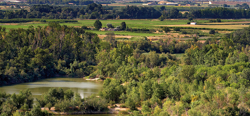
After crossing to the opposite side, the trail turns right onto a dirt track (Mota de Faci), from where there are views of the town of Alfocea. After running 1.5 km parallel to the river, the track turns 90 degrees to the left, disregarding the first entrance to the sedimented meander of Juslibol, then continues due north for a few metres. Soon after, the route leaves the levee behind and descends to the right to a wooded enclave on the sedimented meander. The sedimented meander of Juslibol is a unique wetland. It is an old abandoned meander of the River Ebro in Saragossa, a few kilometres from the city centre.
Within this space, the Ebro Nature Trail winds through signposted paths, skirting around several lagoons, first to the east, then north, and finally across a bridge over the old meander.
Immediately after, the trail runs past Galacho Interpretation Centre, a bioclimatic building where information on the area is available (7.5 km, 1hr 35 min). It then turns right (south) onto the road from Alfocea to Juslibol, at the foot the escarpment, with excellent views over the valley and orchards.

Once in the rural district of Juslibol (9.7 km, 2hr), the trail successively passes next to the Archbishop's Palace, the baroque church of Nuestra Señora de la Asunción and several manors. Past the main square, it descends to the right (south) towards the road to Ranillas. The route reaches the Ebro, winding through orchards, and continues to the left (south) along a track leading to an area near the bridge over the A-2 motorway.
The trail continues a few metres along Ranillas Avenue, which starts at the A-2 motorway underpass. There are two alternative routes from here. The main route heads southeast along the avenue. The other 4.3 km path through Agua Metropolitan Park, (12.2 km, 2hr 30 min), turns right along Ranillas levee (Ranillas meander), skirts around the park and the 2008 Expo Zaragoza site, with views to the Third Millennium Bridge and the Bridge Pavilion, and circles back to Ranillas Avenue.
It then heads southeast to La Almozara footbridge. Here, again, there are two alternatives: the first along the left bank to Almozara Bridge, Macanaz grove and Piedra Bridge. The other winds along the right bank (2.3 km), near La Almozara Bridge, Santiago and Piedra, where both alternatives meet again at the endpoint of this section (205 m, 15.6 km, 3hr and 10 min).
Sites of interest
Puntos de interés
Culture
Hydrography
Information
Infrastructure
Municipality
Profile

 Harshness of natural environment
- 1. The environment is not risk-free
- 2. There are more than one risk factors
- 3. There are various risk factors
- 4. There are quite a lot of risk factors
- 5. There are many risk factors
 Guidance along the route
- 1. Well defined trails and crossings
- 2. There is a clearly marked trail and signage
- 3. Requires the identification of geographic features and cardinal points
- 4. Requires off-path navigation
- 5. The trail is interrupted by obstacles that have to be gone around
 Route difficulty
- 1. Walking on a flat surface
- 2. Trails with different types of path
- 3. Walking on stepped paths or irregular terrain
- 4. The use of hands or jumping over the terrain is necessary
- 5. The use of hands is required to progress
 Amount of effort needed
- 1. Up to 1 hour of continuous walking
- 2. Between 1 and 3 hours of continuous walking
- 3. Between 3 and 6 hours of continuous walking
- 4. Between 6 and 10 hours of actual walking
- 5. More than 10 hours of continuous walking
Highlights
Further information
Sedimented meander of Juslibol
Formed after the flooding of the Ebro on January 2, 1961 (the worst flood of the 20th century), when the flow peaked at 4,130 m³/s (16 times its average rate), it stands as a mute witness to the dynamics of this river. Its uniqueness stems from its location: at the confluence of the river, a gypsiferous escarpment and a steppe area (El Castellar SCI and SPA). Successive gravel extraction has created eleven small lakes in this 102 ha area, which the city of Saragossa acquired for the purposes of protection and management. The site is home to many riparian forest and exotic species, as well as an outstanding variety of bird species, including herons, black-crowned night herons, coots and grebes. In addition to its ecological value, there is also an Iberian settlement (4th century B.C.) and the Castle of Miranda (11th and 12th century) atop the gypsum cliffs located near the sedimented meander.
Multimedia


Downloads

GPS Downloads


