
 del Camino Natural de La Palma")
Net of Nature
Trails

Stage 8: Villa de Mazo - Santa Cruz de La Palma
Description
Closing the circular route through the east middle lands of the island
The final stage of this circular route around La Palma runs through one of the most developed urban areas of the island. Although in some sections the asphalt gives way to the original cobblestones of the Camino Real, the route remains close to residential areas, either in scattered neighbourhoods or in villages like San Pedro (Breña Alta) or Santa Cruz de la Palma. Despite the proximity to urban life, elements of the traditional rural environment of La Palma can still be seen. While walking, it is common to come across small farms and roadside crosses and grottoes. The latter are at the centre of one of the most popular local celebrations, the Fiesta de las Cruces, which is held on 3 May. During this festivity, the crosses are decorated with fabrics and flowers and the best jewellery from each home, offering a spectacle of colour and tradition.

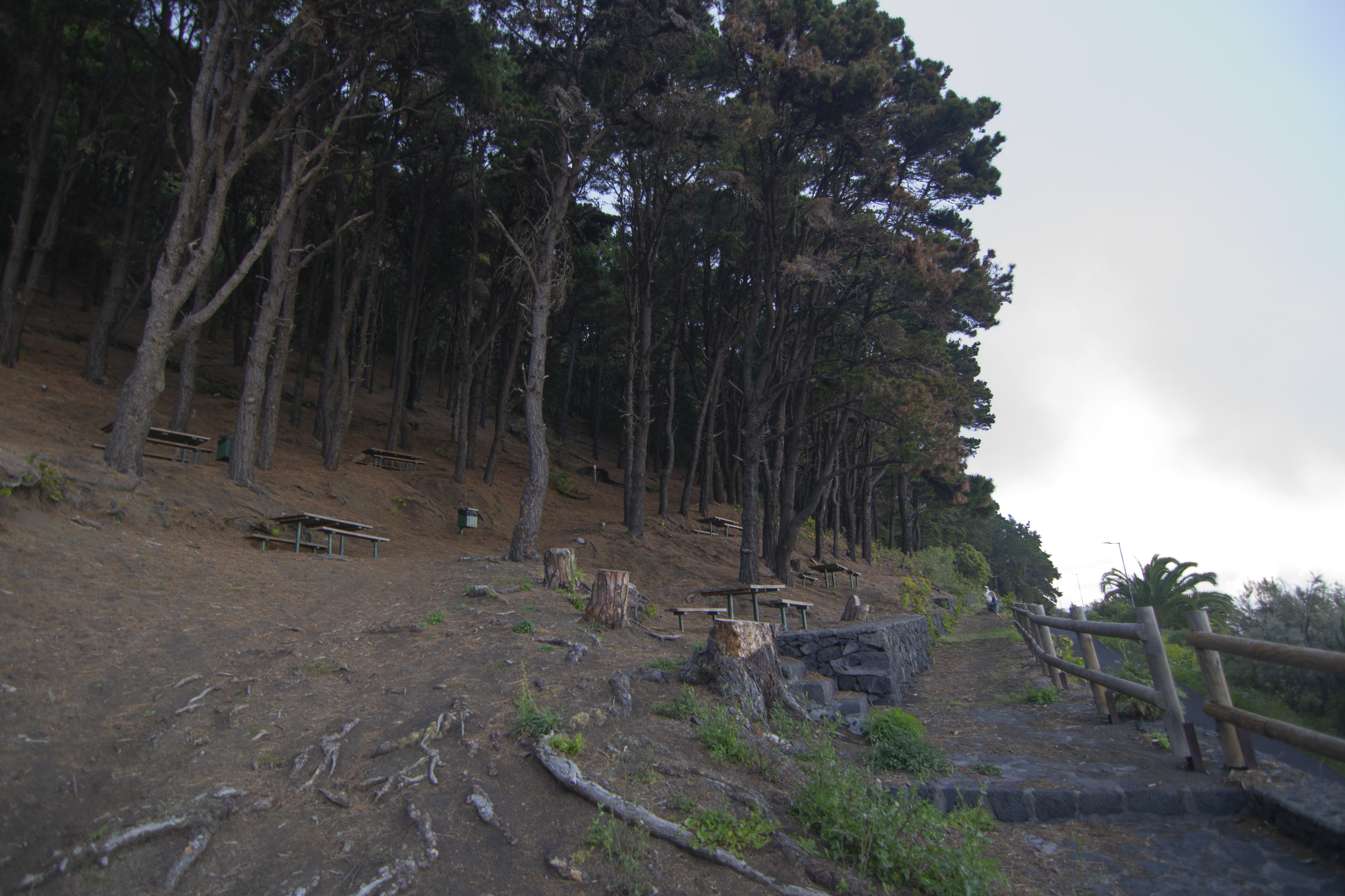
The last stage of the GR130 starts at the Montaña de la Tosca recreational area, located under a leafy pine forest (Pinus halepensis and Pinus radiata) on the slope of the hill that gives it its name. From the top of this mountain, there is natural platform for stargazing which can be accessed from a turn-off about 500 m south of the recreation area.
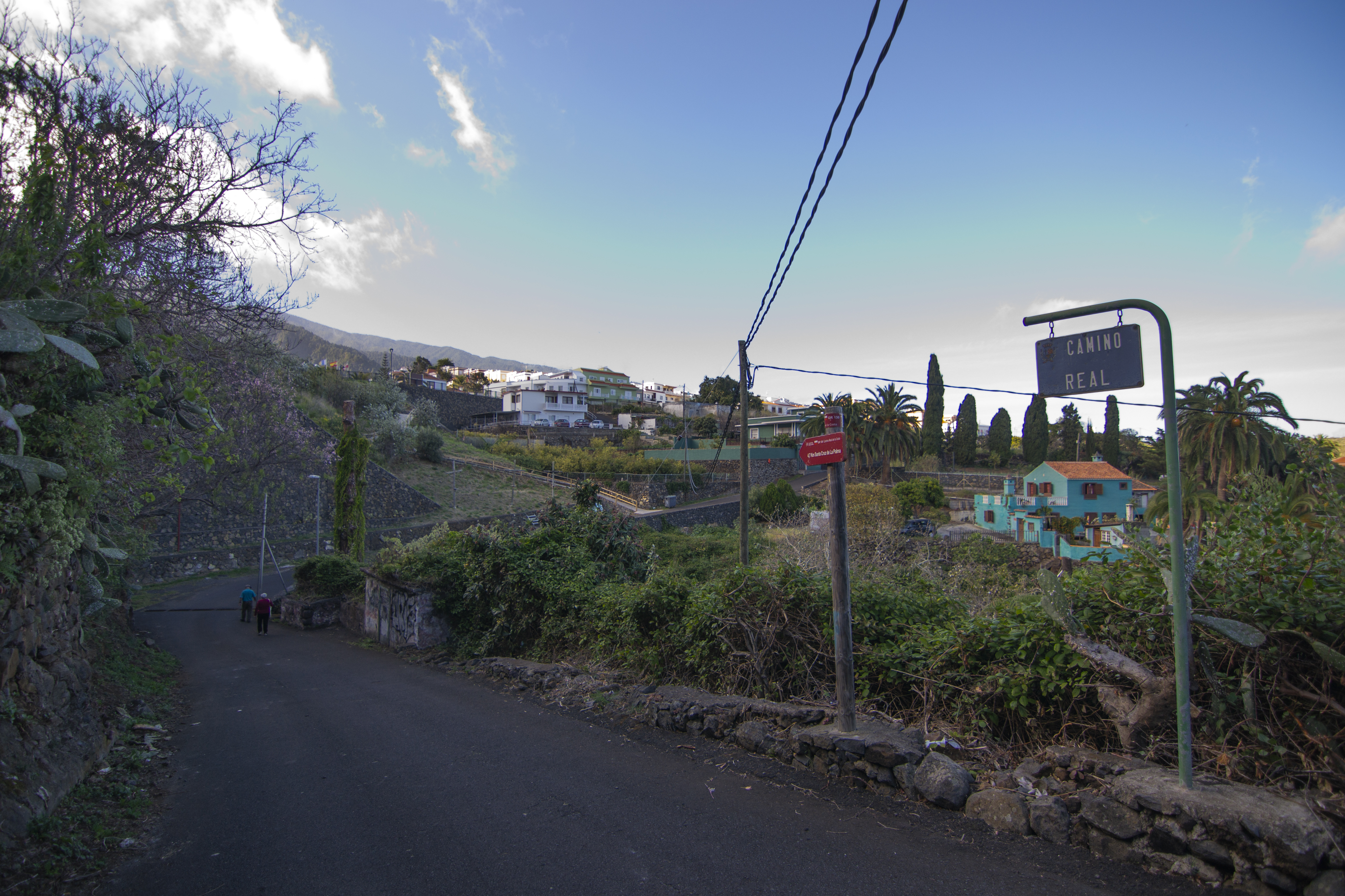
The route continues along the tarmac track on which the last kilometre of the previous stage was covered. It heads north, past a number of detached houses of the El Pueblo district of Villa de Mazo, overlooking the ocean to the east. A short while late, you reach a crossroads with the road that descends to the town centre. Continue straight on, in the direction of the small Pago del Poleal, passing by a niche with a cross.
After a half kilometre, you leave the tarmac to continue along a cobbled path, a reminder of the old Camino Real. This path then enters a wilder area, surrounded by ferns, thistles and other thermophilic scrub. Along the way, we can see the visnea mocanera (Visnea mocanera), Canarian juniper (Juniperus cedrus), fruit trees that have escaped from nearby orchards and the peculiar inflorescences of the swan's neck agave (Agave attenuata).

The trail returns to tarmac next to the Casa del Cura, one of the oldest buildings in the municipality. This house served as a home for the priest who ran the Shrine of San Jacinto and also had another building that was used as a storehouse and shelter for overnight stays for travellers on the Camino Real.
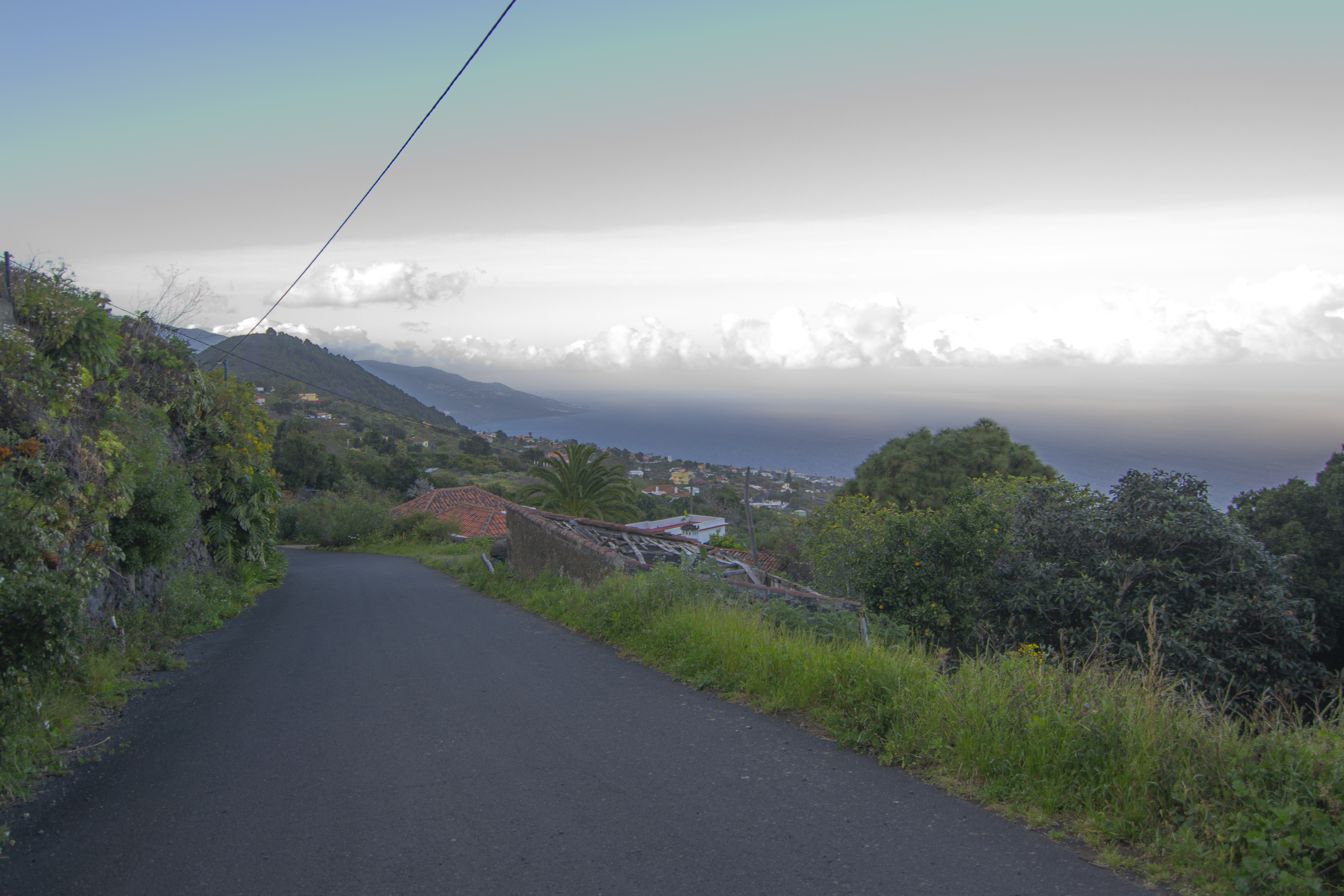
From this point on, one of the most important landmarks of the stage is already perfectly visible, the Breña mountain, which we reach after another kilometre. On the way, it is worth stopping at the recreation area next to the Monte cross, where you can enjoy beautiful views of the mountainside. The scattered houses of Villa de Mazo come into view first, before the banana plantations and finally, next to the ocean, the airport of La Palma. At the foot of the mountain there is a recreation area with parking and an information centre.

The mountain of La Breña stands as a true oasis of vegetation among the more urbanised surrounding areas. The slopes are covered with lush scrubland with a mixture of laurel forest species like heather (Erica arborea), firetree (Myrica faya) small-leaved holly (Ilex canariensis), and others more typical of thermophilic forests such as wild olive trees(Olea cerasiformis), Phoenicean juniper (Juniperus turbinata ssp. canariensis), Visnea mocanera and the Canary Island date palm (Phoenix canariensis).
Although the path deviates from the road to take a path that descends between the mountain and the houses of the Las Ledas district in Breña Baja, there is the option of continuing along the road to the summit, where a viewpoint offers excellent views of the surroundings. The descent ends at a road next to an irrigation pond. From there, cross the road to cross a small hill with a concrete irrigation channel.
The route continues along the road, crossing the Barranco de Amargavino ravine, where you take a concrete track north, soon joining an asphalted road. As we continue through the fields and rural houses, passing by several crosses like the cross of Miranda or the cross of Rosal, located next to the simple Shrine of San Miguel Arcángel, the path crosses the road several times until it reaches the Barranco Loja del Llanito ravine. After fording the river, the route climbs up a cobbled path until it reaches the town of San Pedro, the capital of Breña Alta.

After crossing the LP-204 road, the route continues through the streets of San Pedro, passing by the Church of San Pedro and the Town Hall. From here, the route continues parallel to the road for almost 2 km when the street climbs up to meet the road in the Buenavista district. For the next kilometre, the trail runs alongside the road, mostly the pavement, although in some sections it is necessary to walk on the hard shoulder, requiring due care, especially at roundabouts. It is worth taking a temporary detour from the route to visit the Shrine of Nuestra Señora de la Concepción and a spectacular viewpoint, both located on the Risco de la Concepción, a volcanic building of submarine origin in the shape of a crescent, declared a Natural Monument in 1987.
On the way back to the main route, we take a detour from the LP-202 down the streets of the La Cuesta district, which is perched at the top of the Risco de la Concepción. We soon pass a small square where the unique cross of Los Bolos is located and, a little further, the Maroparque Isla de La Palma gate, a zoo-botanical park that serves as a rescue centre for exotic animals. The descent follows the twists and turns of the road and, flanked by buildings all the way down, you hardly notice that you have passed from the municipality of Breña Alta to that of Santa Cruz de La Palma.
To conclude the stage, all that’s left to do is to finish the descent along Calle San Sebastián, now in the centre of Santa Cruz. Here we pass by the shrine of the same name, before reaching the steps leading down to the Plaza de España, but not before passing by the building of the Royal Cosmological Society, which also houses the municipal library. In the Plaza de España in Santa Cruz de la Palma, at the foot of the Church of Matriz de El Salvador facing the Town Hall, our adventure of almost 150 km around the Isla Bonita comes to an end.
Puntos de interés
Municipality
Orography
Hostel
Profile

 Harshness of natural environment
- 1. The environment is not risk-free
- 2. There are more than one risk factors
- 3. There are various risk factors
- 4. There are quite a lot of risk factors
- 5. There are many risk factors
 Guidance along the route
- 1. Well defined trails and crossings
- 2. There is a clearly marked trail and signage
- 3. Requires the identification of geographic features and cardinal points
- 4. Requires off-path navigation
- 5. The trail is interrupted by obstacles that have to be gone around
 Route difficulty
- 1. Walking on a flat surface
- 2. Trails with different types of path
- 3. Walking on stepped paths or irregular terrain
- 4. The use of hands or jumping over the terrain is necessary
- 5. The use of hands is required to progress
 Amount of effort needed
- 1. Up to 1 hour of continuous walking
- 2. Between 1 and 3 hours of continuous walking
- 3. Between 3 and 6 hours of continuous walking
- 4. Between 6 and 10 hours of actual walking
- 5. More than 10 hours of continuous walking
(Calculated according to the MIDE criteria for an average excursionist with a light load)
Highlights
Further information
Risco de La Concepción
The Risco de La Concepción, located in the municipality of Breña Alta, is a Natural Monument protected under Law 12/1994 of December 19, 1994. It is part of the Canary Islands Network of Protected Natural Spaces (ENP) and the Natura 2000 Network as a Special Area of Conservation (SAC).
This dramatic cliff, with a drop of over 300 meters, marks the southern edge of Santa Cruz de La Palma. Formed by a phreatomagmatic hydrovolcanic eruption, it is geologically significant and one of the youngest volcanic features on the island. Its crescent-shaped structure and eroded eastern face, sculpted by the sea, create an awe-inspiring coastal landscape.
With its yellow volcanic rock and unique formation, Risco de La Concepción is a prime destination for lovers of geology, science, and nature. It harbours vegetation typical of thermophilic forests, including cardonal-tabaibal at lower altitudes and monteverde species in moister zones. The site is ideal for observing flora and fauna, photography, excursions, and scientific research.
At the summit, 400 meters above sea level, stands the Shrine of Nuestra Señora de La Concepción, built in the early 16th century and rebuilt in 1672. Inside are religious paintings from the 17th and 18th centuries. The shrine’s viewpoint offers spectacular panoramic views of Santa Cruz de La Palma.
La Breña Mountain
La Breña Mountain is a cinder cone formed by volcanic material such as lapilli and basaltic scoria. Its main ecological value lies in the presence of the priority habitat “Macaronesian laurel forests (Laurus, Ocotea),” which led to its designation as a Special Area of Conservation (SAC) under the Natura 2000 Network.
The vegetation includes transitional laurel forest blending with thermophilic woodland. Species such as heather (Erica arborea), firetree (Myrica faya), and small-leaved holly (Ilex canariensis) mix with thermophilic species like Canarian wild olive (Olea cerasiformis), juniper (Juniperus turbinata ssp. canariensis), mocán (Visnea mocanera), Maytenus canariensis, St. John’s wort (Hypericum canariensis), and Canary Island date palm (Phoenix canariensis).
In areas closer to human activity, nitrophilous vegetation appears, with plants such as marguerite daisy (Argyranthemum frutescens), mountain daisy (Argyranthemum broussonetii), incienso canario (Artemisia thuscula), jediondo (Bosea yervamora), duraznillo (Ceballosia fruticosa), cabezón (Cheirolophus canariensis), la corona de la reina (Gonospermum fruticosum), Canarian tree mallow (Lavandula canariensis), malva de risco (Lavatera acerifolia), Canary Island sorrel (Rumex lunaria), and Canarian sage (Salvia canariensis).
La Breña’s vegetation is also composed of sub-nitrophilous grasslands and a reforested area of Canary Island pine (Pinus canariensis). In addition to its botanical value, the mountain shelters a notable population of beetles, including Curimopsis dacilae, a species first described in this location.
Multimedia


Downloads


