
 del Camino Natural de La Palma")
Net of Nature
Trails

Stage 5: Tijarafe - Los Llanos de Aridane
Description
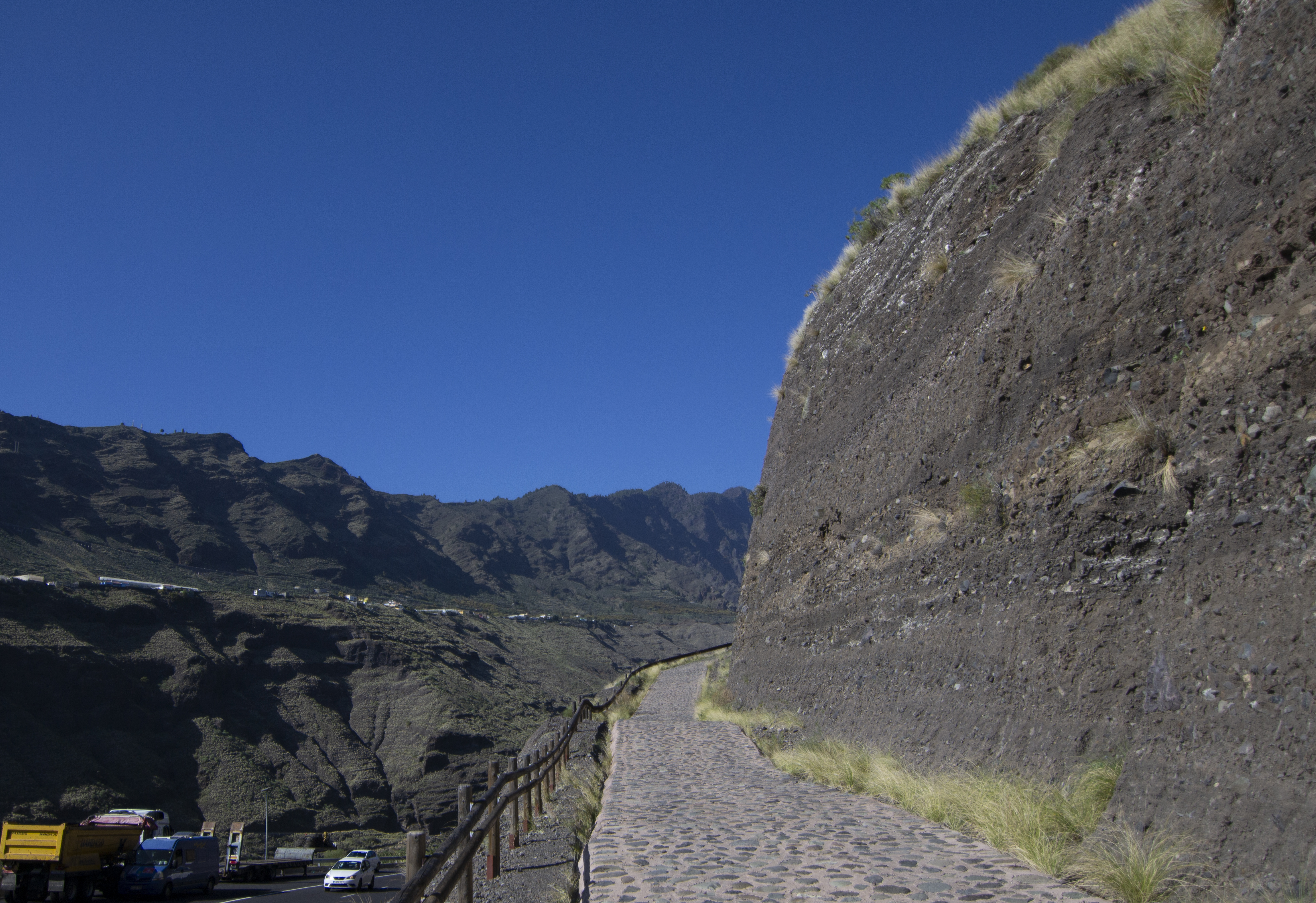
Towards the Barranco de las Angustias ravine and the Aridane Valley
One of the shortest stages of the GR 130, but also one of the most challenging, it offers spectacular views of the Barranco de las Angustias ravine and the Aridane Valley from the natural viewpoint of the Laderas de Amagar. On this route, just over 13 km long, you will experience some of the most dramatic landscape changes: from the rugged surroundings of ravines and scattered dwellings to the imposing rock walls of the Angustias ravine and the extensive banana plantations. Finally, you reach Los Llanos de Aridane, one of the biggest towns on La Palma. Throughout the stage, we have the opportunity to explore the island’s rich variety of cultural landscapes.

Stage 5 of the GR 130 starts in the village of El Pueblo de Tijarafe, just behind the Church of Nuestra Señora de la Candelaria. This church stands out for its sober design and unusual bell tower with a balcony that can be accessed from external stairs. Inside, the coffered ceiling and the impressive main altarpiece, the work of the sculptor Antonio de Orbarán, are striking. From the church, a stairway leads down to the square, passing between a magnificent Indian laurel (Ficus microcarpa) and a Canary Island palm (Phoenix canariensis).
This square offers panoramic views of the landscape of Tijarafe, the ocean and the curious roofs of the local buildings. Before continuing, we recommend a visit to the tourist information office and the local library, the upper floor of which houses the Luis Lorenzo Barreto Ethnographic Museum. You’ll find a fascinating collection of traditional costumes from the municipalities of La Palma.
The route starts on a descent as far as the LP-1 road, which it follows for about 100 m before leaving it on the left hand side along a dirt track. This track passes behind a house and goes up a small hill before meeting the road again on the way down. After crossing the road, pay special attention to the bend on the left, the path then descends towards the Barranco del Jurado ravine. This ravine is named after the geological formations sculpted by erosion and known by the locals as "juros" and was declared a Natural Monument in 1987. Climbing up the opposite slope, we reach the Shrine of Buen Jesús, a simple temple dating back to the late 16th century and declared a Protected Cultural Heritage site in 1994, popularly known as "El Jesús". This shrine is much loved by locals, so much so that it has given its name to the district of Tijarafe in which it is located.

Our trail continues through the streets of the lower part of "El Jesús", crosses a small ravine and reaches the LP-1 road at the Fuente del Toro recreational area. After crossing the road and skirting the recreational area on a cobbled path, the path turns into a concrete path that passes through the more scattered houses in the upper part of the village. Along the route there are several crosses that mark the route of the old Camino Real.
The concrete gives way to a dirt track that descends towards the Los Gomeros ravine. From there, the path climbs up the opposite slope until it reaches a road that serves the houses in the Arecida district. Continue along this road as it descends to meet the LP-1 again. From this point, the route follows the old Camino Real, staying at a lower level than the road as it heads towards the district of La Punta. Over this stretch, the landscape mixes cultivated areas and new tourist or residential uses of the old houses. The road surface alternates between asphalt and concrete and the most picturesque cobblestones.
After passing the small district of La Punta, you cross the road again and begin a slight but steady ascent until you reach the municipal boundary between Tijarafe and Los Llanos. Once at the top, the view opens up to the spectacular landscape of the Aridane Valley. At this point, the GR 130 path crosses the first stage of the GR 131, which climbs from Puerto de Tazacorte to Roque de los Muchachos. It is the perfect place to stop, admire the scenery and recharge your batteries before tackling the demanding the descent that awaits the walker.
This section of the path, popularly known as Las Vueltas de Amagar, descends in a convoluted zigzag to overcome a drop of more than 500 m from the start of the descent to the bottom of the Las Angustias ravine. The course is estimated to have up to 73 laps, making it a remarkable challenge. After a first steep downhill stretch and a junction with the road where, although vehicles do not usually go very fast due to the gradient, it is advisable to pay attention, especially when curves reduce visibility, you reach the Amagar plain, which offers some rest. A terrace suspended from the old riverbed, where the banana plantations occupy practically the entire surface and the path runs between them.

We cross the road again, a particularly dangerous point because visibility is limited due to the sharp bends and the terrain itself. Then the descent continues to the LP-1. At this point we cross again at a point with better visibility, and continue descending to the bottom of the ravine. Before crossing and continuing with the stage, you can visit the Sanctuary of La Virgen de Las Angustias, about 300 m to the left along the road. This 16th century building, with a single nave, houses a Baroque altarpiece and a magnificent Flemish polychrome carving. It is worth mentioning that this was one of the first religious constructions built by the Spaniards on the island.
On returning to the path, we cross the road and take a footbridge over bed of the ravine. On the other side, the trial takes us through banana plantations once again and begins to climb the other side of the Barranco de Las Angustias ravine. We have to cross the road three more times before taking a cobbled path that climbs steadily upwards with little change direction. The road leads to the district of Argual, already integrated in the urban area of Los Llanos de Aridane.
From here, the path enters the streets of Los Llanos, so it’s important to take extra care at the crossings. The route passes first along Calle Velázquez, then along Calle Manuel de Falla and then along Avenida de Tanausú. The stage culminates in the Plaza de España, the heart of the city, where there are large Indian laurels brought by the emigrants to Cuba. The stage ends here, between the Church of Nuestra Señora de los Remedios and Los Llanos de Aridane Town Hall.
Puntos de interés
Culture
Municipality
Hostel
Profile

 Harshness of natural environment
- 1. The environment is not risk-free
- 2. There are more than one risk factors
- 3. There are various risk factors
- 4. There are quite a lot of risk factors
- 5. There are many risk factors
 Guidance along the route
- 1. Well defined trails and crossings
- 2. There is a clearly marked trail and signage
- 3. Requires the identification of geographic features and cardinal points
- 4. Requires off-path navigation
- 5. The trail is interrupted by obstacles that have to be gone around
 Route difficulty
- 1. Walking on a flat surface
- 2. Trails with different types of path
- 3. Walking on stepped paths or irregular terrain
- 4. The use of hands or jumping over the terrain is necessary
- 5. The use of hands is required to progress
 Amount of effort needed
- 1. Up to 1 hour of continuous walking
- 2. Between 1 and 3 hours of continuous walking
- 3. Between 3 and 6 hours of continuous walking
- 4. Between 6 and 10 hours of actual walking
- 5. More than 10 hours of continuous walking
(Calculated according to the MIDE criteria for an average excursionist with a light load)
Highlights
Further information
Barranco de Las Angustias Ravine
The Barranco de Las Angustias ravine is part of the Canary Islands Network of Protected Natural Spaces and is designated as a Special Area of Conservation (SAC) within the Natura 2000 Network. Its significance lies in its geological and climatic features, which give rise to La Palma’s unique vegetation, including forests of Canary Island Pine (Pinus canariensis).
Located on the western side of La Palma, it spans the municipalities of El Paso, Tijarafe, Los Llanos de Aridane, and Tazacorte. It forms the natural outlet and boundary of the Caldera de Taburiente. Environmental highlights include ancient basalt rock formations, extensive areas of plutonic rocks, steep cliff walls, a dense network of dykes and springs, and the spectacular Cascada de Colores (Waterfall of Colours).
Exploring the Barranco de Las Angustias offers visitors not only dramatic geological scenery but also an opportunity to witness and help preserve its rich biodiversity. Among the flourishing plant life, the Canary Island Pine is predominant, thriving along the slopes of the ravine and forming characteristic forest landscapes. Other notable plants include Palm Lavender (Lavandula buchii) and the striking Red Tajinaste (Echium wildpretii), with its tall red flower spikes during bloom. Wildlife in the ravine includes several endemic species, such as the La Palma giant lizard (Gallotia auaritae) and the laurel pigeon (Columba junoniae).
The ravine also holds deep historical significance tied to the Benahoarita culture—the original inhabitants of La Palma. It played a key role in the Aridane canton of the Benahoaritas, who used its natural resources for agriculture and water supply. The permanent stream known as Dos Aguas served as a crucial water source for irrigation and still contributes to local farming today.
For all these reasons, the Barranco de Las Angustias ravine remains a captivating destination that draws visitors for hiking, nature sports, or simply to enjoy a walk through its breathtaking landscapes.
Shrine of Nuestra Señora de Las Angustias
Located within the awe-inspiring setting of the Barranco de Las Angustias ravine, in the municipality of Los Llanos de Aridane, stands the Shrine of Nuestra Señora de Las Angustias. This sanctuary is notable not only for its spiritual significance but also for its surroundings—lush vegetation, banana plantations, and rugged ravine slopes.
The shrine was constructed in the 16th century in Baroque style and was built to house a polychrome wooden sculpture of Flemish origin depicting the Pietà—the Virgin Mary holding her crucified son. This work of art arrived on La Palma between 1515 and 1522 and is remarkable for the upright posture of the Virgin contrasting with the contorted body of Christ in her lap.
The façade features Baroque design, including a triple niche where the image of the Virgin Mary is placed. Inside, a Baroque altarpiece and central niche emphasize the sculpture’s presence. The sanctuary also contains sacred objects such as an imperial crown, Christ's potencies, and a large silver cross. Eath year on August 15th, the shrine becomes a gathering point for devotees and pilgrims during the procession to Calvary in honor of the Virgin. Eight days later, the “octava” is celebrated with a second procession around the sanctuary, marking it as an essential religious and cultural event for the island community.
Multimedia


Downloads

GPS Downloads


