Net of Natural
Trails

Stage 4: Tefía - Betancuria
Description
To the Historic Capital of the Island
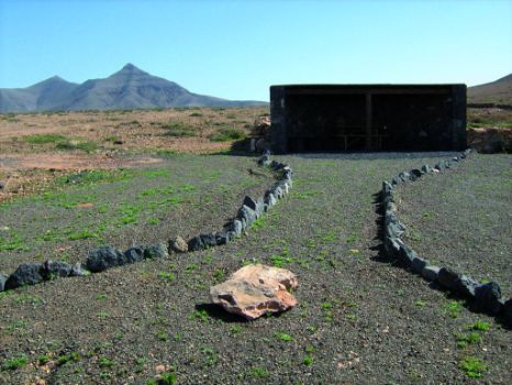
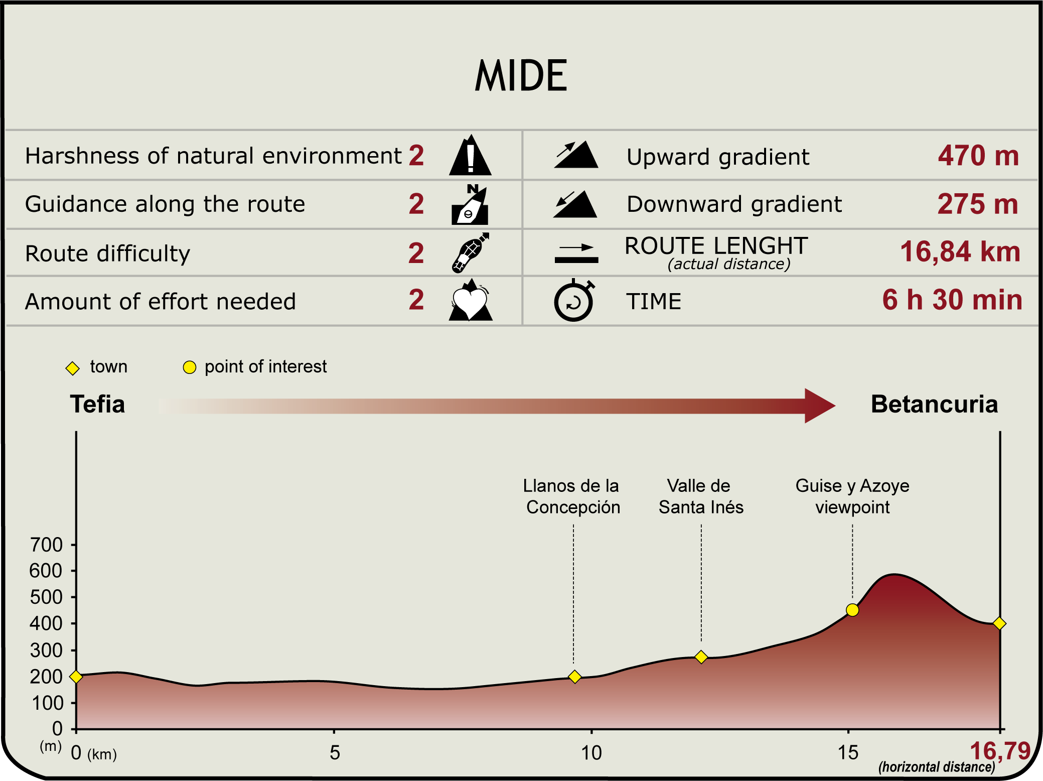
From the shrine of San Agustín de Tefía, the Nature Trail heads toward the historic capital of the island, Betancuria, which we reach after having skirted the unmistakable Montaña Bermeja and crossed Santa Inés valley, from which the trail leads the village of the same name, founded in the fifteenth century during the Norman conquest of Fuerteventura.
The stage begins at the shrine of San Agustín de Tefía, which is also the point of departure of path PR FV 15.1, which goes through the Tetir valley until reaching the village of the same name. At first, this section follows a road in a southerly direction, until it comes to a junction where the trail connects with path PR FV 15, which, just as the path mentioned above, leads to the village of Tetir, although by way of Casillas del Angel.

On reaching the junction, the main path follows a northwesterly direction and goes down a track that leads towards the Museum Alcogida, where we can appreciate the traditional architecture of the old buildings housing the museum, as well as various items of the local crafts of the island. Located in the southern part of Tefía, this museum is named after it location near an “alcogida”, that is a terrain designed to collect rainwater.
The ecomuseum is a village consisting of a set of houses representative of the traditional domestic architecture of Fuerteventura, in a setting that recreates life in a traditional agricultural village. The museum offer us the opportunity to get acquainted with local handicrafts, and the livestock and agricultural works carried out by the inhabitants of the island on a daily basis, as well as their traditions and customs.

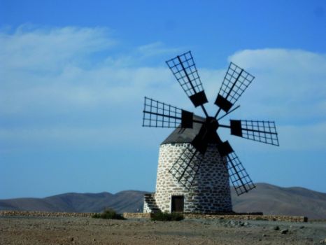
Once we have visited the Alcogida Ecomuseum, we cross FV-207 and continue the trail toward the beautiful Tefía Windmill - declared an asset of cultural interest – which has the peculiar feature of having six blades instead of four.
This traditional windmill consists of a building made of stone, clay and lime, on a circular base in the shape of a truncated cone. The upper part of the windmill consists of a wooden cone holding the blades, and the interior is divided into two or three floors. The ground floor was used to store the tools and gear of the miller, while the first or “middle” floor was a grain storage space. The upper floor housed the internal works of the windmill.
However, the so called Molina (square windmill) is a more modern building, designed in the nineteenth century by Isidoro Ortega, who was born in La Palma. His design has the added benefit of grouping on a single floor all the functions of a mill, namely grain grounding and processing, so that the miller is spared the effort of having to move from one floor to the other carrying heavy grain sacks. These molinas usually have a square or rectangular base supporting a wooden tower that houses all the works.

From the windmill of Tefía we head south to Montaña Bermeja, a mountain that is unmistakable due to its reddish hue and its jagged contours, in addition to the fact that it is crisscrossed by two deep ravines. Shortly afterwards, we find a resting area made of stone with a roof, where we can shelter ourselves from the unrelenting rays of the sun.
Past the resting area, the main road continues along a dirt track through the plains of Llano de Leme, until we reach the village of Los Llanos de la Concepcion, where we can visit the shrine. We leave this town behind us, and we continue along the trail in a southerly direction, gaining some height as we begin to climb the hill of Tetir. As we go up the hill, we walk past a windmill of six blades at Los Llanos de la Concepción, which, as the windmill at Tefía, has been named an asset of cultural interest.
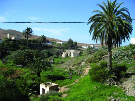
From the hill of Tetir we can enjoy sweeping views of Santa Inés Valley, where the green hues of a small ravine stand out against the landscape due to the presence of more luxuriant and larger plants, as well as some palm trees (Phoenix canariensis). Some of these palm trees are preserved in the village of Santa Inés, which was one of the first settlements established near Betancuria owing to the existence of arable land in the region, and we can enjoy views of the region from one of the restaurants or eateries of the village.

The trail continues along the road through Santa Inés Valley, upstream, until we enter Parque Rural de Betancuria (Betancuria Natural Park) where the road ends. In the vicinity of Santa Inés Valley several tamarisks (Tamarix spp.) stand out, although the most widespread vegetation consist of open bush, mainly Mediterranean saltwort or “salada” (Salsola vermiculata) and aulaga (Launaea arborescens).
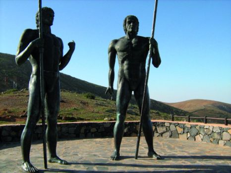
We will leave now Santa Inés Valley to climb a hill from which we can enjoy the unique landscape of the Rural Park. The route runs along the hill, until it crosses the road that goes down to Betancuria. In this part of the trail we find the scenic overlook of Guise y Ayose, located on the ridge or “degollada” of Corrales de Guise. From this vantage point we can admire the village of Betancuria and enjoy a beautiful view of the central/northern part of the island, the villages scattered across the valleys, the plains, mountainous reliefs and deep ravines to the east. The overlook features two sculptures figuring Guise and Ayose, kings of the two opposing tribes dominating Fuerteventura before the European conquest.

Before reaching the village of Betancuria, we see mainly communities of wild tabaiba (Euphorbia regis-jubae), fields of prickly pear cactus or tuneras (Opuntia spp.) and brushes of jorjados or Canary Island daisy (Asteriscus sericeus). On our descent to the village, we walk past the waterwheel Pozo de los Peña. Once in Betancuria, this section of the trail comes to an end on the back side of the Catedral de Santa María (Santa María Cathedral), where we can see informative panels on the Nature Trail.
This town, founded in about 1404 during the conquest of the island by the Normans, was named after the conqueror Jean de Bethencourt. It was one of the first towns founded in the Canary archipelago by Europeans, who chose for this purpose an inner valley, distant from the coast and surrounded by mountains, not only for military and defensive reasons, but also because of the fertility of the land owing to the presence of water. However, its strategic location failed to prevent the invasion of Fuerteventura by the Berbers in 1593, and the assault on many buildings of Betancuria, including the cathedral.
Puntos de interés
Culture
- Ermita de San Agustín
- Ermita de Santa Inés
- Ermita de Nuestra Señora de la Concepción
- Molino de Tefia
- Catedral de Santa María de Betancuria
- Noria del pozo de los Peña
Information
Municipality
Orography
Profile
(Calculated according to the MIDE criteria for an average excursionist with a light load)
Highlights
Further information
Parque Rural de Betancuria
Betancuria Rural Park is the largest natural space of Fuerteventura, with an area of 16,544.3 ha, including the municipalities of Puerto del Rosario, Betancuria, Antigua, Pájara and Tuineje. This protected area, reclassified as a rural park in 1994, stands out for its geological characteristics and the unique morphology of its beautiful scenery, with U-shaped cliffs and very rugged terrain. Virtually the entire park is formed by the rocky outcrops of the Fuerteventura basal complex, which occupy the west side of the island. The Natural Monument of Ajuí is also within the confines of the park.
Betancuria Rural Park, along with the peninsula of Jandia, is home to the greatest plant biodiversity on the whole island. Many rupicolous (rock-dwelling) plants grow in the rocks and massifs, and some of them belong to endangered species. There are also some species introduced into the island, such as tree tobacco (Nicotiana glauca).
Many of the animal species that live in the area belong to protected and endangered species. Particularly important are birds, which is the reason why the entire park has been declared a special protection area for birds (SPA). The eastern part of the park is an important habitat for prey birds, such as the common buzzard of the islands (Buteo buteo insularum), the common kestrel (Falco tinnunculus) and the southern grey shrike (Lanius excubitor koenigi). Smaller species, such as the hoopoe (Upupa epops) and the African blue tit (Parus caeruleus) can also be seen in the area.


