

Net of Nature
Trails

Stage 7: Els Alocs– Cala de Algaiarens
Description
Walking along the northern coast of Menorca between dunes, beaches and pinewoods
From the secluded cove of Ets Alocs to the area surrounding Cala d'Algaiarens, stage 7 of the Camí de Cavalls runs for 9 km along the north of the island, passing through some of the most significant enclaves of the Marine Reserve of the North Coast of Menorca, such as El Pilar Cove and its surroundings. Continuing westwards, the route crosses the wild olive, lentisk and pine forest of the Muntanya Mala hill until it enters the agroforestry mosaic of Vall d'Algaiarens. Its last stretch crosses some fields and goes along the edge of a patch of trees over the Platja des Tancat dune, and ends at the car park at Cala d'Algaiarens.

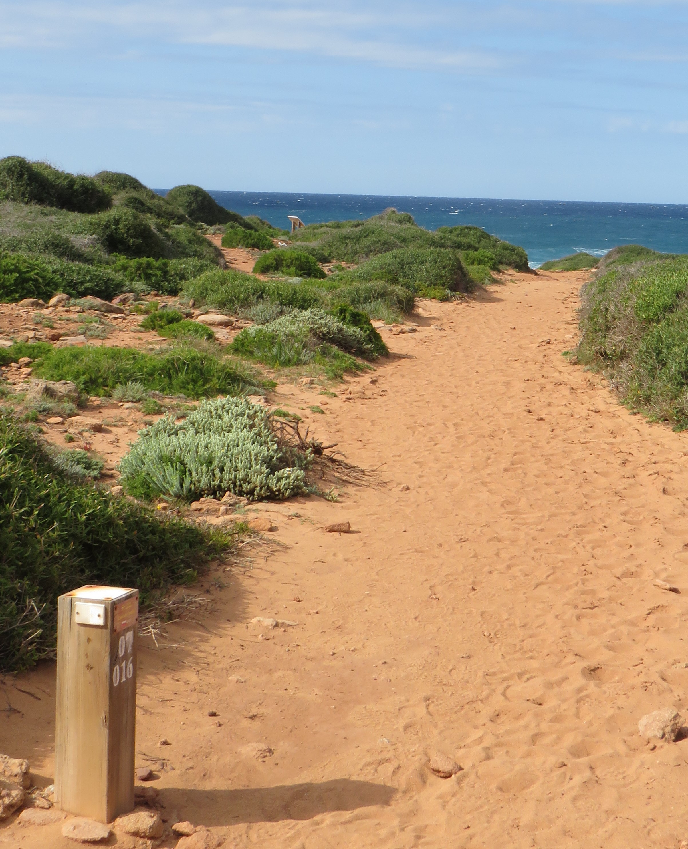
The start of stage 7 can be somewhat complicated as it is located on the secluded beach of Els Alcos, situated to the north of the municipality of Ferreries between Escull des Barco and Punta des Alocs. This point can be reached by following the Camí de Cavalls route from stage 6.
Els Alocs is a small unspoilt cove that is included in the North Coast Marine Reserve. Its name is a reference to the chasteberry trees that grow in the area, locally known as alocs (Vitex agnus-castus). This is the starting point of stage 7, which heads west along a signposted path with fences and stairs that climb along the edge of the cliff. The first few metres of the route you will walk over basaltic outcrops, in a dark, stony landscape of small cliffs no higher than 40 m, at the point in which the Mediterranean Sea and the tramontane winds meet. In this stretch, you will sea coastal scrubland such as the labiérnago (Phillyrea latifolia var. rodriguezii), although tree patches can be seen inland.
After the first kilometre of this stage, there is a major change of scenery that will take to the El Pilar Cove, which is accessed by wooden stairs. The trails ascends to an altitude of 70 m, following the coastline across a landscape that gives Mars more than Menorca. This is due to the intense reddish hue of the sandstone and clay that compose the ground of this area of the island, which were washed away by the rivers that ran across the area 252 million years ago.

The system of sandstones and sands in the are present high salinity levels, on which plant communities that are highly adapted to the environment have grown. Thus, here it is possible to find some of the island's most remarkable endemic species, such as the herba de cotó (Thymelaea velutina) or the socarrells (Launaea cervicornis) intermingled with the pine tree patches and the centenary evergreen oak grove of Alfurí, separated by a rest area.
The stage continues to the west, following a path located on the hill that separates the El Pilar Cove and the beach in Macar d'Alfurinet, also known as Pla de Mar. After 3 km, the route reaches the striking beach of Macar d'Alfurinet with its reddish rocks, and which is also impressive for being a valley wedged between two mountains at an altitude of no more than 100 metres. To reach it, the route descends following the path, which is adapted with low steps to prevent slips and falls. It passes next to a farm and what appears to be a well but in reality hides the access to a copper mine.
Once you have passed the Macar d'Alfurinet, the Camí de Cavalls continues inland along the left side of the valley, going through a striking change of scenery. Behind you are the salty grounds, the wind and the sound of the waves, while ahead, the trail continues by an agricultural area and enters the forest of the Muntanya Mala.

This section runs for approximately 4.5 km through this wooded area and crosses the Muntanya Mala mountain range. Along the route there is a mixture of agricultural plots and specimens of wild olive tree (Olea europaea var. sylvestris), Aleppo pines (Pinus halepensis), evergreen oak (Quercus ilex), lentisk (Pistacia lentiscus), labiérnago and different species of green heather (Erica sp.). In addition, if you pay a little attention you will be able to spot several species of birds, both sea birds and birds of prey, along with small birds such nightingales; reptiles, including the Italian wall lizard (Podarcis sicula) and small mammals such as the Balearic hedgehog (Atelerix algirus vagans), although livestock species are more visible, especially the Minorcan goat.
Once through the forest, the stage enters the Vall de Algaiarens, a mainly agricultural area across which 2 km of track run, passing through a crossroads that indicates that the trail turns northwards and enters a coastal pine forest once again. At this point you will find the turn-off to Platja des Tancant, located 200 m away. From this turn-off, stage 7 of the Camí de Cavalls runs along the last 600 m bordering the evergreen oak and pine forest that develops in the sandy area of Algaiarens to the car park of Cala d'Algaiarens.
Links of interest
Profile

 Harshness of natural environment
- 1. The environment is not risk-free
- 2. There are more than one risk factors
- 3. There are various risk factors
- 4. There are quite a lot of risk factors
- 5. There are many risk factors
 Guidance along the route
- 1. Well defined trails and crossings
- 2. There is a clearly marked trail and signage
- 3. Requires the identification of geographic features and cardinal points
- 4. Requires off-path navigation
- 5. The trail is interrupted by obstacles that have to be gone around
 Route difficulty
- 1. Walking on a flat surface
- 2. Trails with different types of path
- 3. Walking on stepped paths or irregular terrain
- 4. The use of hands or jumping over the terrain is necessary
- 5. The use of hands is required to progress
 Amount of effort needed
- 1. Up to 1 hour of continuous walking
- 2. Between 1 and 3 hours of continuous walking
- 3. Between 3 and 6 hours of continuous walking
- 4. Between 6 and 10 hours of actual walking
- 5. More than 10 hours of continuous walking
(Calculated according to the MIDE criteria for an average excursionist with a light load)
Highlights
El Pilar Cove
This beach is located on the north coast of Menorca, in the municipality of Ciutadella and is part of the Marine Reserve of the North Coast of Menorca. This is one of the best-preserved unspoilt coves on the island thanks the fact that it is difficult to be accessed, which also makes it an crowd-free place. It is a small shell-shaped bay, located between the cove of Els Alocs and Macar d'Alfurinet.
Its orientation north cause it to be stricken by heavy waves famous Tramontane winds blow, although a small islet acts as a partial parapet.
El Pilar Cove is part of the so-called The Red Menorca. This term refers to the clays and sandstones that deposited in the northwestern area of the island during the late Palaeozoic, 252 million years ago, by the large rivers that dominated the island during this period. This phenomenon resulted in a golden sandy beach surrounded by red mountains covered with vegetation.
Around the beach there is a dune system and a forest of white pine and evergreen oaks at the back, located on the Alfurí de Dalt farm, which is home to an important natural and ethnological heritage, as it is used in a sustainable manner for agriculture and livestock farming and charcoal production purposes. It is also the point with the highest concentration of endemic plants in Menorca, which allows it to be registered as a SCI (Site of Community Interest) and NAI (Natural Area of Interest).
Please remember that you must respect all signs and the areas provided for access to the beach, as well as to avoid leaving any waste or debris in the environment.
Multimedia


Downloads

GPS Downloads


