

Net of Nature
Trails

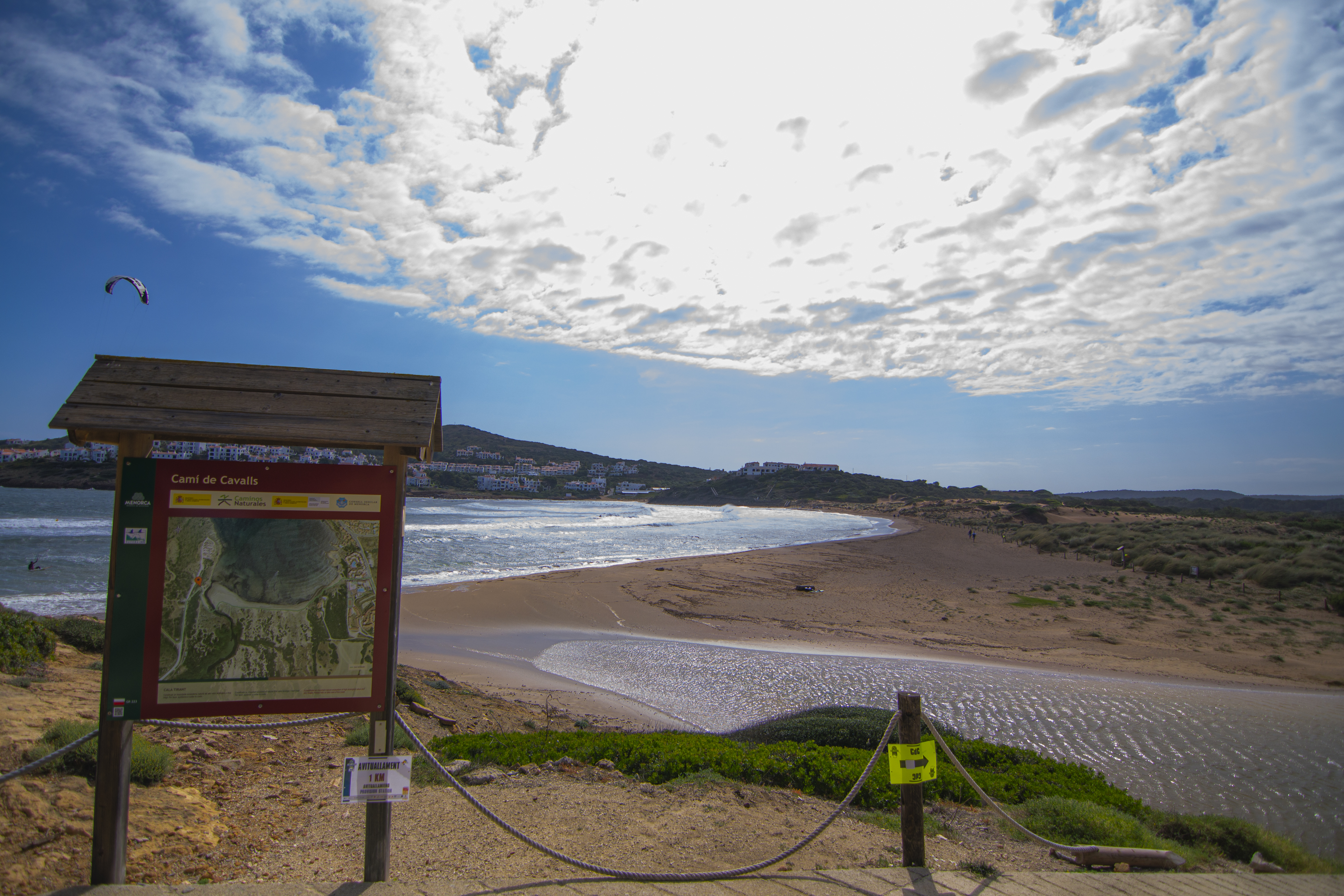
Stage 5: Cala Tirant - Binime·là
Description
- - - - - - - -
IMPORTANT NOTICE!
DUE TO THE EFFECTS OF THE INTENSE RAINS, THIS STAGE OF THE NATURAL TRAIL IS CLOSED DUE TO ITS POOR CONDITION AND, FOR SAFETY REASONS, MAY REMAIN TEMPORARILY CLOSED.
IT IS RECOMMENDED TO PLAN ALTERNATIVE ROUTES AND EXERCISE CAUTION IN AREAS CLOSE TO THESE POINTS. INFORMATION WILL BE UPDATED AS THE EVALUATION AND REPAIR WORKS PROGRESS.
THANK YOU FOR YOUR UNDERSTANDING.
- - - - - - - -
Roman heritage in the north of Menorca
Starting from the Playas de Fornells housing development, this stage runs along some of the most popular beaches and coves on the north coast of Menorca, one of the best preserved areas of the coast, which as been declared the "Dels Alocs a Fornells” SCI and SPA . During the route you will reach the northernmost point of the entire Camí de Cavalls Nature Trail, in the vicinity of the ancient Roman settlement of Sanicera.

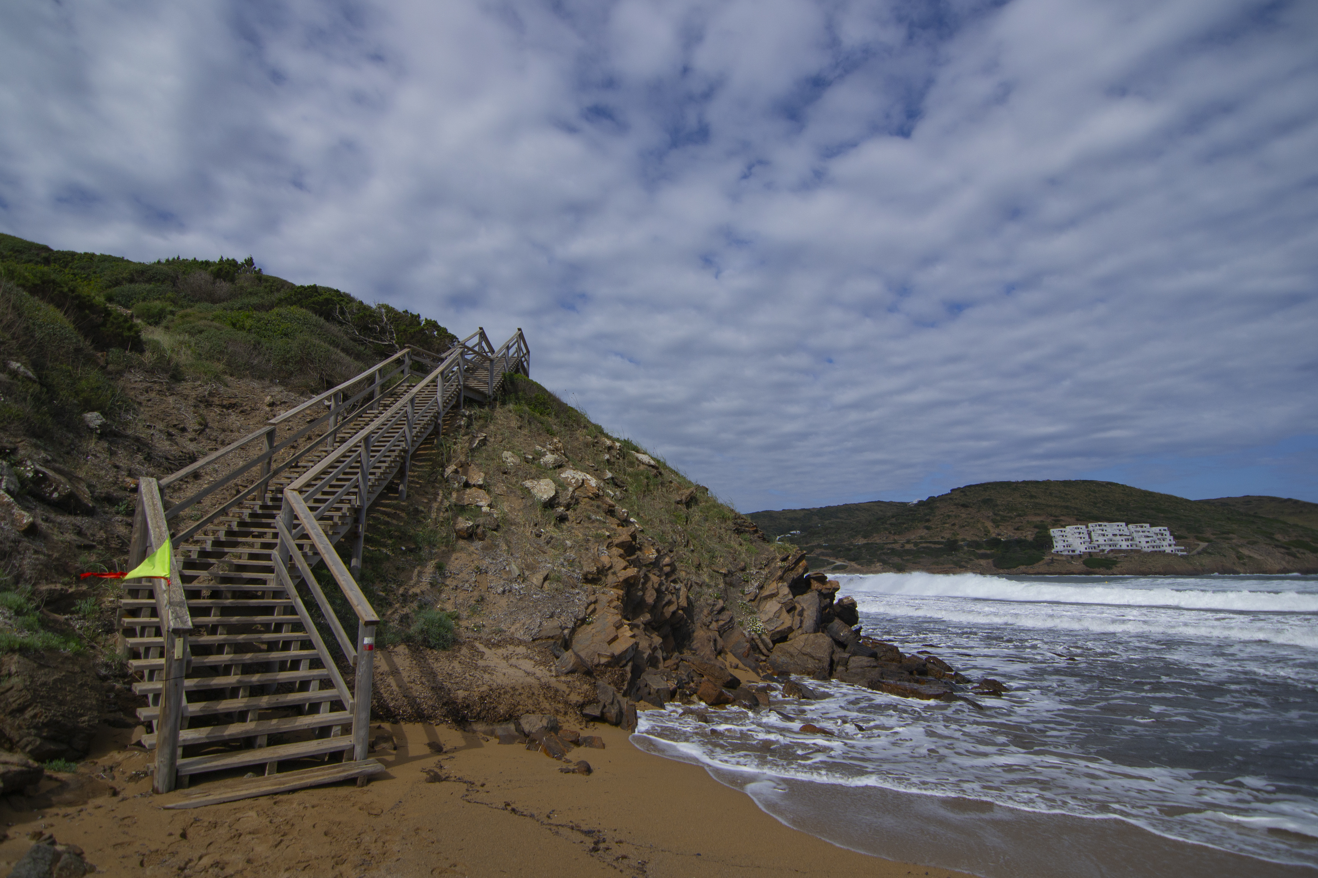
The fifth stage of the Nature Trail begins right at the entrance of Tirant Cove, in the residential complex of Playas de Fornells. The trail moves away to the beach to overcome a small headland that cuts in half the sandy area by using a wooden walkway that rises some 10 m above sea level, offering beautiful views of the natural harbour formed by this cove.
On the way back, the path skirts the beach without reaching the other end, as shortly before it leaves the beach, turns left and takes a footbridge built over the Lluriac Nou wadi. The trail continues parallel to this stream for a little less than 100 m, between tamarisk (Tamarix sp.) and sand couch-grass (Stipa sp.), until you reach the end of the creek. At this point, the trail begins a climb along a concrete path that leads to the access road to a housing estate.
The trail continues along this dirt track to the south, before taking a track to the right shortly afterwards. This other track is left after half a kilometre and the route continues along a path that starts on the right. Please be careful treading and crossing these paths, as they are access roads to residential complexes and are therefore they are used by cars.

The Nature Trail heads back towards the coast, among pastures, sand couch-grass and some cushion-like scrubs, and reaches the Macar de sa Talaieta (macar is the Menorcan word for small rocky beaches). From this point onwards, the path runs almost parallel to the coastline and, even it is protected by wooden guards when it gets too close to the cliffs, you have to be careful because it runs along a dirt path with rocky outcrops.
The surrounding landscape does not change much: pasture slopes; sand couch-grass; scrubland, especially lentisk trees (Pistacia lentiscus), green olive tree (Phillyrea latifolia), scorpion broom (Genista scorpius) and especially socarrells (Launaea cervicornis), endemic shrubs adapted to the environmental conditions of the north of the island, with some sparse trees; and to the right of the path you will see the natural port of Tirant Cove to the right of the path, and enjoy beautiful views of the residential complex of Playa de Fornells.
The trial continues passing by different coves and capes, but without actually reaching any of them: Punta de sa Talaieta, Macar Petit, Punta Negra, Macar Gran, Macar de Binidonaire, Sa Mitjana, Punta d'en Patet and, finally, the D'en Patet beach.
The path then heads inland again, leaving the beach along a track that leads to a private estate. After walking along this track for about 200 m, the trail leaves it to take a path to the right. Among good-sized lentisk trees, in the first stretch, and Aleppo pines, later on, the trail goes around the aforementioned farm until you are near the ancient Roman settlement of Sanicera.

Just before reaching the access road to the Cavallería lighthouse, information boards have been installed in the esplanade in which you can learn about this Roman enclave, located at the northernmost point of the entire route of the Camí de Cavalls. This enclave consisted on a campsite built during the Sertorian War (82 b.C. to 72 b.C.) to house soldiers. The actual settlement of Sanicera, a late Imperial Roman port, was located further north on the west side of the port of Sanitja.
A small path that reaches off from the road about 200 m to the west of the information boards leads to Sanicera, which is just over half a kilometre away. On your way there you will walk past other archaeological landmarks such as a church complex dating from the 5th and 6th centuries.
Another interesting heritage element is the Sanitja tower, a coastal defence tower built by the British in the 18th century and standing at the end of Punta de sa Torre. Finally, from here you can reach the cape and lighthouse of Cavallería, 2.5 km away, located at the northernmost tip of the island of Menorca.

The route continues along the road leading to the lighthouse, heading west for 1.3 km until the car park at Cavallería beach. Again, please be extremely careful when walking along the road, especially when arriving at the car park, especially in the summer season when there is large number of cars.
After leaving the car park, the path heads towards a small headland, Punta Roja, which separates Roja Cove, to the north, from Cavallería beach, to the south. Shortly before going down to the beach, at the foot of a rocky outcrop, a resting area has been installed which also serves as a viewpoint towards Cavallería beach. The reddish soil explains the name of the area, Punta Roja, literally “Red Point” in Spanish, which makes a stark contrast with the yellow-white colour of the sands of Cavalleria. After going around the rocks, a wooden walkway with some steps will allow you to go down to the beach where, attached to the rocky wall, a bunker from the Spanish Civil war is preserved. T
he trail crosses the beach of Cavallería all the way to the end, leaving it just at the point where the beach of Ferragut begins. The path climbs upwards, running along the top of the walls that enclose the beach. The uneven surface, first sand and then loose pebbles, together with the height above the beach, requires a certain amount of caution, but it is worth the effort when you look back just before crossing a Menorcan gate: a beautiful view of the beaches of Ferragut and Cavallería, the unmistakable Punta Roja and Punta des Vernís in the background.

The route continues running close to the cliff, through a fairly rugged terrain between rocks, where the vegetation is reduced to some almost creeping bushes, and to other species endemic to the Balearic Islands, the Menorca’s wild chamomile (Santonina chamaecyparissus subsp. magonica). After passing by some fishermen's houses, the path then descends towards Mica Cove, although you will hardly have time to step on the sand as you will leave the cove immediately after crossing a gate next to another Spanish Civil War bunker.
Here the vegetation starts to become more abundant, with the slopes on the sides of the path covered with sand couch-grass and balloons and the return of the company of mastic trees. The route continues along the coastline for another half kilometre before doing a 90-degree turn next to a Menorcan gate. The path goes around a small hill and connects with a fairly wide track that continues for about 200 m and leads to some rural lodgings, so you may come across some motor vehicles.
The trail then descends along a path, a little hard to identify at times, which leads back to the coast. Once parallel to the coastline, you will pass a small cove of fine sand and soon reach the end of the route, just at the entrance to the popular Binimel·là beach.
Links of interest
Profile

 Harshness of natural environment
- 1. The environment is not risk-free
- 2. There are more than one risk factors
- 3. There are various risk factors
- 4. There are quite a lot of risk factors
- 5. There are many risk factors
 Guidance along the route
- 1. Well defined trails and crossings
- 2. There is a clearly marked trail and signage
- 3. Requires the identification of geographic features and cardinal points
- 4. Requires off-path navigation
- 5. The trail is interrupted by obstacles that have to be gone around
 Route difficulty
- 1. Walking on a flat surface
- 2. Trails with different types of path
- 3. Walking on stepped paths or irregular terrain
- 4. The use of hands or jumping over the terrain is necessary
- 5. The use of hands is required to progress
 Amount of effort needed
- 1. Up to 1 hour of continuous walking
- 2. Between 1 and 3 hours of continuous walking
- 3. Between 3 and 6 hours of continuous walking
- 4. Between 6 and 10 hours of actual walking
- 5. More than 10 hours of continuous walking
(Calculated according to the MIDE criteria for an average excursionist with a light load)
Highlights
Sanicera and Roman Menorca
The Balearic Islands were conquered by consul Quintus Caecilius Metellus between 123 and 121 BC with the purpose to be used as an enclave to fight against Mediterranean pirates. He called Menorca Balearis Minor or Minorica. According to Pliny the Elder, in Roman times Menorca had three cities: Mago, present-day Maó; Iamo, present-day Ciutadella; and Sanisera, in the port of Sanitja.
Originally, the town of Sanisera was built to take advantage of the natural port. This site was located on the western shore of the port of Sanitja, which at that time was further out to sea and had a deeper draught, allowing the anchoring of larger vessels. Near the port, during the civil conflict known as the Sertorian War (82 BC. - 72 BC), a small military campsite defended by a moat was built.
Although its heyday was from 123 BC to the 2nd century AD, this enclave was used until late antiquity, as evidenced the various archaeological finds in the area. Apart from the port itself and the aforementioned camp, there is an industrial zone from the Late Roman Empire (284-476); a church complex from the Vandal and Byzantine periods; six necropolises from different periods of late antiquity and even a 13th century mosque built with reused Roman ashlars.
In more recent times, the port has continued to be of strategic importance, with the construction of a defensive tower in the early 19th century, during the British rule of the island.
Cavalleria Lighthouse
This building is located at the northernmost point of the island, overlooking the impressive, almost vertical cliffs of Cape Cavalleria. Its white tower is 15 m high and the lighthouse ran on oil until the end of the 20th century
It was inaugurated in 1857 and was the first lighthouse to be built on the north coast of Menorca. The Cavalleria lighthouse was built to reduce the number of shipwrecks along this stretch of the coastline, since more than 700 shipwrecks were recorded in the area since the 14th century. Although the lighthouse was successful in reducing its number, shipwrecks continued to occur. This led to the construction of the Punta Nati and Favàritx lighthouses at the beginning of the 20th century.
The lighthouse is open to the public from May to October and houses the Cape Cavalleria Interpretation Centre.
Multimedia


Downloads

GPS Downloads


