

Net of Nature
Trails

Stage 17: En Porter Cove - Binissafúller
Description
Discovering Menorca's agricultural landscape and hidden coves
Over the course of this route, the Camí de Cavalls path passes through two sharply contrasting environments; from the uneven layout of the ravines in the western part of the island to the flat, less rugged area in the east. Starting from En Porter Cove, one of the most important ravines on the island, the trail transitions from forest to an agroforestry mosaic before arriving at Cala des Canutells. From here the trail descends in altitude, passing through other ravines such as Binidalí and Biniparratx, which, although smaller in size, lend a great deal of charm to the landscape. As you reach the end of the route, you leave behind the humid environments of the ravines and enter the Menorcan agroforestry mosaic of pastureland, farmland and scrubland.

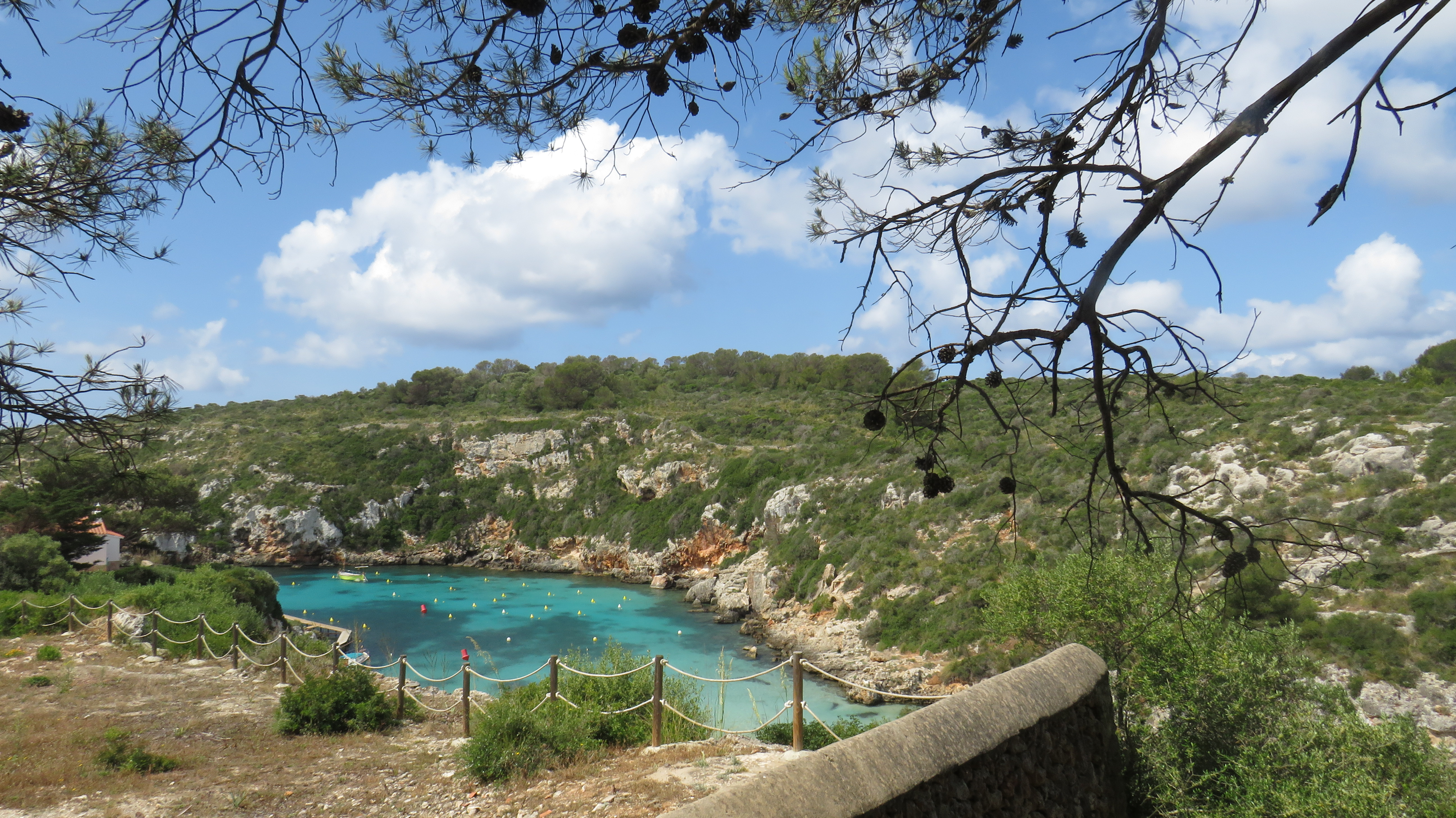
The panel indicating the start of the stage is located in the deepest spot of En Porter Cove. This is located in the western side of the island, wedged between the imposing limestone cliffs of the ravine with which it shares its name and which is one of the most important on the island, thanks to a permanent flow of water that allows wetland vegetation to flourish, making it one of the protected areas of the Natura 2000 Network. Here you can find wild blackberry bush (Rubus ulmifolius), reeds(Phragmites australis), bay laurel bush (Laurus nobilis) and leafy wild olive trees (Olea europaea var. sylvestris). There are also small frogs, some colubrid snakes and birds such as Eurasian blackcaps (Sylvia sp.), Cetti’s warblers (Cettia cettí) and herons (Ardea cinerea).
From the information panel, the trail climbs up the Carrer Platja de Cala en Porter, leaving the ravine behind and entering a residential complex on the left cliff of the ravine, skirting it along the Paseo Marítimo. From here, there is a beautiful panoramic view of the Mediterranean as it sneaks in land between the cliffs with the houses of the residential complex perched above, the beach and the course of the ravine towards the interior of the island.
After about 800 metres, the stage turns into the Travessia de L'Avinguada Central, which crosses Cala en Porter to the sports centre. Here the path enters the Carrer Art, turning northwards, until it reaches its end, where a traditional Menorcan gate in front of the houses indicates the start of the route through the mountains.

From this point, the stage begins its route along a well-marked path between traditional Menorcan gates and stone walls that separate the forest of evergreen oaks (Quercus ilex), Aleppo pines (Pinus halepensis) and wild olive trees from the agricultural plots cultivated with cereals and pastures. During the first section of the path, approximately one kilometre long, the stage crosses the Son Domingo ravine and continues its descent to the deep into the ravine where you’ll find the Coles Coves beach. During this stretch, the surface is practically homogeneous, except at certain points, especially on the steepest descent, where roots and rocks protrude from the striking reddish earth.
At the bottom of the ravine the air is cool and damp, as the trail towards the east wall, where you can see some shelters, caves and rocky outcrops, with a proliferation of a fairly leafy forest of wild olive and laurel trees. At this point you may even find the pampalonia (Paeonia cambessedesii), a plant with lilac flowers that is endangered and endemic to Mallorca and Menorca. There is also a rich avifauna, with birds of prey such as the sparrowhawk (Accipiter nisus), the kestrel (Falco sparverius) and the kite (Milvus milvus), as well as Egyptian vultures (Neophron pernocterus) bats, lizards or geckos in the rocky areas, and even hedgehogs (Athelerix algirus), shrews (Crocidura suaervolens balearica) and dormice (Eliomis quercinus), among the scrubland.

Continuing along the path next to the limestone wall, the trail gradually ascends, from a cool and humid environment to a drier and warmer one that develops in the higher areas. This new section continues for approximately two kilometres, in an easterly direction, as the agroforestry mosaic emerges above the limestone plateau. This stage of the trail runs between agricultural estates delimited by walls and traditional Menorcan gates, through areas of forest and Mediterranean scrubland, along a route with little or no gradient and a homogeneous surface from which limestone rocks or roots occasionally protrude.
About 4.5 km from the start, the route turns south and begins to descend, leaving the elevated area of the limestone plateau and entering the Es Canutells ravine, where you will find the beach of the same name and in the deepest part of which you will find one of the few elm tree formations on the island. Continuing southeast, the trail leaves the ravine and ascends along a somewhat steep path until it reaches the top of the left cliff where the Es Canutells residential complex is located. Upon completing the ascent, the stage comes to a rest area under a pine grove that also serves as a viewpoint of Cala Es Canutells.

Once past the rest area, continue through the residential complex following Carrer de Sa Cala heading south and turn east at the intersection with Avinguda des Canutells.
Continuing straight on, the avenue becomes a cobbled promenade along which the stage advances, leaving the developed area and entering the verge of the island road that gives access to Es Canutells, running alongside the road traffic for 1.75 km. During this section, extreme caution is recommended. At the end of this road section, the trail turns eastwards again, taking an easily navigated path between agricultural holdings delimited by walls, wild olive and mastic trees (Pistacia lentiscus) before giving way to a dirt track framed by walls. Once past the rest area, continue through the residential complex following Carrer de Sa Cala heading south and turn east at the intersection with Avinguda des Canutells. Continuing straight on, the avenue becomes a cobbled promenade along which the stage advances, leaving the developed area and entering the verge of the island road that gives access to Es Canutells, running alongside the road traffic for 1.75 km. During this section, extreme caution is recommended. At the end of this road section, the trail turns eastwards again, taking an easily navigated path between agricultural holdings delimited by walls, wild olive and mastic trees (Pistacia lentiscus) before giving way to a dirt track framed by walls.
After passing the tower of S'Argossam, the trail crosses the Binidalí road, continuing between scattered houses before turning east again and crossing the Biniparratx ravine, which is much shallower and lusher in comparison to the others. Past the ravine, the stage crosses the Biniparratx Petit path and runs along its last stretch for a little over a kilometre along an uneven and stony path, surrounded by scrubland and descending in a southerly direction until you reach the panel that indicates the end of the stage in Binisafúller, at the beginning of Avinguda Platja Binisafúller, opposite the Caló Blanc carpark.
Links of interest
Puntos de interés
Culture
Orography
Profile

 Harshness of natural environment
- 1. The environment is not risk-free
- 2. There are more than one risk factors
- 3. There are various risk factors
- 4. There are quite a lot of risk factors
- 5. There are many risk factors
 Guidance along the route
- 1. Well defined trails and crossings
- 2. There is a clearly marked trail and signage
- 3. Requires the identification of geographic features and cardinal points
- 4. Requires off-path navigation
- 5. The trail is interrupted by obstacles that have to be gone around
 Route difficulty
- 1. Walking on a flat surface
- 2. Trails with different types of path
- 3. Walking on stepped paths or irregular terrain
- 4. The use of hands or jumping over the terrain is necessary
- 5. The use of hands is required to progress
 Amount of effort needed
- 1. Up to 1 hour of continuous walking
- 2. Between 1 and 3 hours of continuous walking
- 3. Between 3 and 6 hours of continuous walking
- 4. Between 6 and 10 hours of actual walking
- 5. More than 10 hours of continuous walking
(Calculated according to the MIDE criteria for an average excursionist with a light load)
Highlights
Cales Coves Beach
Cales Coves is a small, unspoilt double cove situated a short distance east of En Porter Cove. What’s so special about this cove, with its sandy beach less than 20 m long, is that it is home to an important prehistoric necropolis excavated in the cliff walls flanking it on either side.
This is a group of artificial caves and hypogeum, excavated in the rock of the cliffs and the coast, where some 90 burials have been counted. The necropolis was used for about 1000 years, from the 11th century BC to late antiquity.
In Roman times, although it lost its use as a necropolis, it seems that it continued to be a place of worship or pilgrimage, as attested by a series of rupestral inscriptions in the Cova dels Jurats.
Apart from the necropolis, this cove, which is well protected from the winds and tides, was an important dock between the 4th century BC and the 6th century AD, as can be seen from the ceramic remains found at the bottom of the cove. There are also remains of a fortified coastal settlement, of which part of a wall survives.
Es Castellàs des Caparrot de Forma
Es Castellàs des Caparrot de Forma is a prehistoric archaeological site located on the south coast of Menorca. What’s so unique about is the fact that within it there are two sites with different chronologies and functionalities.
One is a coastal fortification and a necropolis consisting of several hypogeum can thus be distinguished. On the promontory closest to the coast, remains have been found of what may have been a settlement from the late Bronze Age, including a wall of considerable proportions that closes off access to this area from the mainland. It was formed by a wall of large stones that served as a bastion to isolate the caparrot or headland.
Within these walls, two circular constructions were built using small stones. The excavations carried out in this area have uncovered the remains of vases used in the daily life of the ancient inhabitants, as well as various tools, such as two hand mills for crushing grain.
On the other hand, there is a necropolis in the cliff area consisting of a total of 23 caves or hypogeum dating from the Iron Age.
This complex, located near the Des Canutells residential complex, has been declared an Asset of Cultural Interest (BIC).
Talayotic Settlement of Binissafúller
This was a small settlement. According to the excavations carried out, it was in use from the 10th century BC, especially between the 4th and 3rd centuries BC, and it is likely that this continued until the Muslim period.
It is known for the great variety of remains it contains, including those characteristic of this type of settlement, such as the taula, or T-shaped monument enclosure, the talaiots, the hipostyle hall and some dwellings.
One of the main elements of this site is a circular talaiot located in the centre of the settlement, with the rest of the structures found around it. It consists a tower in the shape of a trunk with a diameter of 15 m and a height of 2.8 m, standing on a low artificial mound.
On the eastern side there is a well-preserved hypostyle hall, which has survived to the present day with part of its roof still intact. Three enormous pilasters support large slabs laid horizontally and intertwined with each other.
To the south is the taula of the settlement. It is somewhat different from the rest of those found in Menorca as it has a square floor plan, but with rounded corners, which can be explained by the use of an existing wall for its construction. This enclosure is quite small, less than 5 metres, and thanks to a restoration carried out in 1992 it has been restored to its original position.
Excavations in this part of the complex have shed great deal of light on the type of activities that took place there. Many Punic amphorae were recovered and, in addition, bones of various animals were found near a hearth, suggesting that some kind of ritual related to fertility, animals and the countryside took place during the 4th-3rd century BC.
Multimedia


Downloads

GPS Downloads


