

Net of Nature
Trails

Stage 6: Luque Station – Doña Mencía Station
Description
A path between castles, caves and olive groves
Between the old stations of Luque and Doña Mencía, this stage runs guarded by olive groves and Mediterranean forests, crossing landscapes that combine the rough landscape with historical remains. You will admire amazing rock formations within the Sierras Subbéticas Natural Park and World Geopark, castles that dominate the horizon and beautiful villages that preserve the genuine Andalusian charm. All the sections of the route so that each section of the route invites to stop, explore and connect with the essence of this Andalusian region.

The route begins at the old Luque railway station, now restored as a restaurant. In the surrounding area there are car parks, accommodation facilities and a picnic area; this is a peaceful area that makes an ideal starting point. The route follows the old 19th century Linares-Puente Genil railway line, which ensures a steady and comfortable route, without too many slopes or interruptions.
A few metres from the start you can take a branch road that after 8 km reaches Baena. This branch starts at a metallic footbridge that crosses the N-432 road, advances through olive groves and approaches the N-432 road again, finally crossing it by an underpass, returning shortly afterwards to the old railway line and, after zigzagging for a while, in a final section that runs parallel to the road until it reaches Baena.
On the way back to the main route, you will have to be extremely cautious when crossing a road, and then you will continue westwards. Approximately one and a half kilometres away there is a rest area with tables, benches and a parking area. Next to it, there is an old fountain and a crossroads with the CO-6203 regional road that leads to Luque.

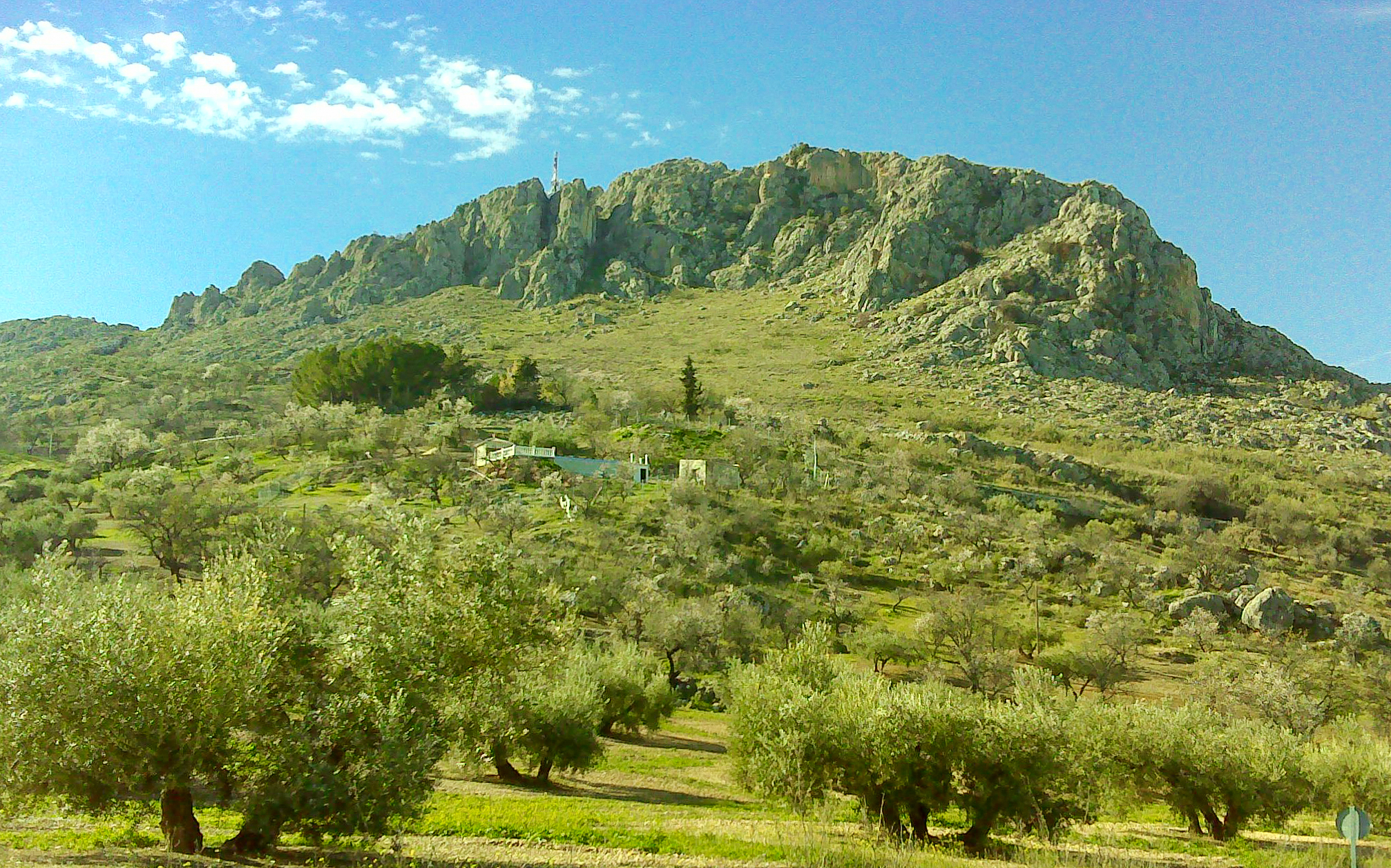
Although the landscape is dominated by olive groves, this stage crosses the Sierras Subbéticas Natural Park and World Geopark, where a place were water has carved limestone into whimsical shapes. These formations become more visible shortly after crossing the CP-150 road, as from this point onwards the path skirts the hills of the sierra, leaving the olive groves to the right.
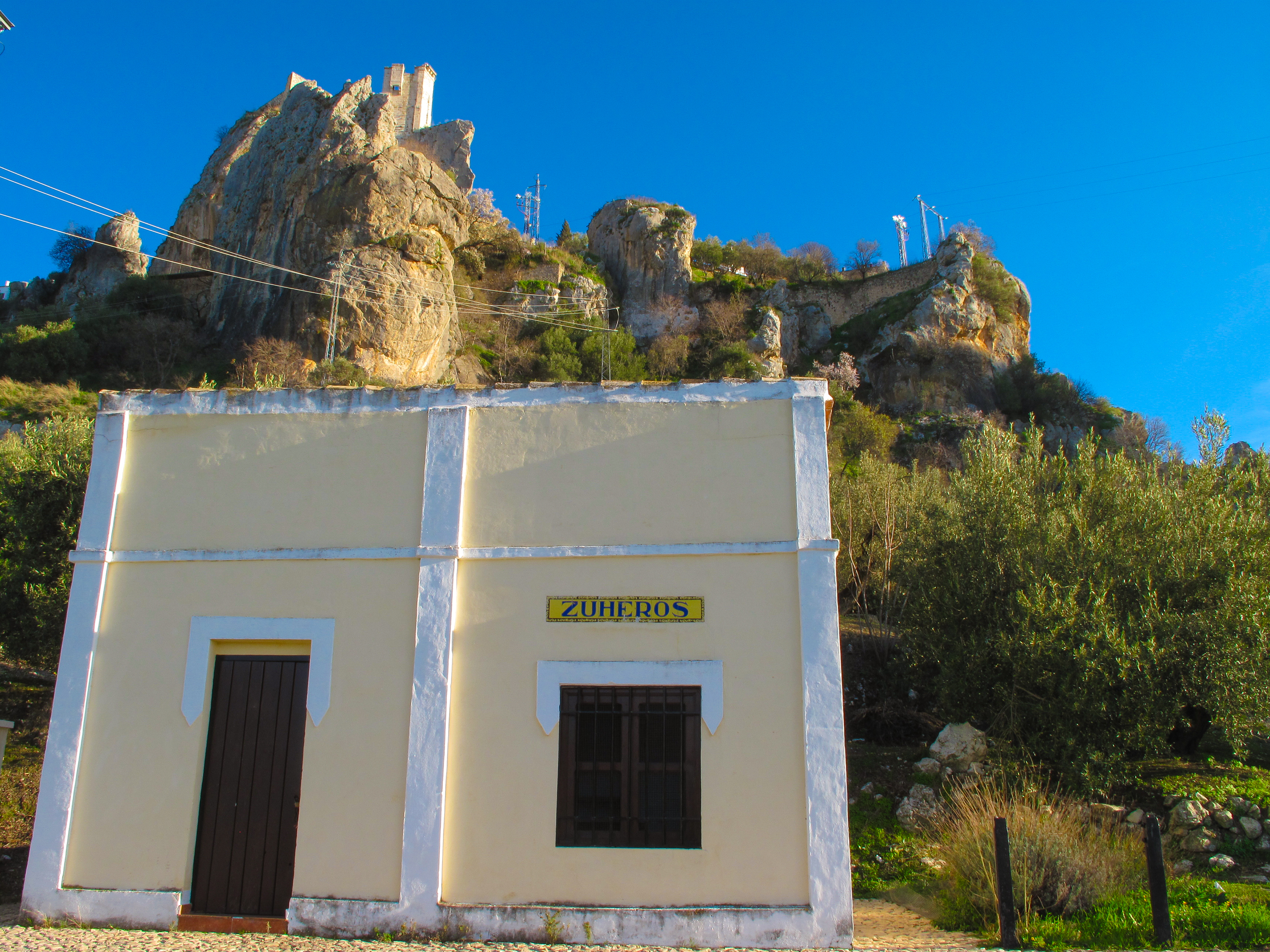
One kilometre from Zuheros, under the shadow of its Arab castle, you will find, next to the intersection with the CO-6209 road, an old railway building converted into a museum-studio, tourist information centre and resting area. Nearby is the town’s public swimming pool, ideal for relaxing and cooling off in the warmer months.
The next stop on the route is the old station of Zuheros, from where you can visit the Cueva de los Murciélagos (Spanish for “the bat cave”), a Natural Monument of great geological and historical value. It is also worth taking a stroll through the streets and squares Zuheros, declared an Site of Cultural Interest and considered one of the most beautiful villages in Spain since 2016.

From Zuheros there are several trails that lead to the Sierras Subbéticas Natural Park, such as the Bailón River Trail, known for its spectacular scenery and rich biodiversity. Returning to the route, the path crosses the river over the Zuheros viaduct of great monumental value and winds through patches of Mediterranean woodland with holm oaks and carob trees, while in the background the rocky crests of the sierra, the only areas not occupied by olive groves, can be seen.
The stage, which is barely 10 kilometres long, ends at the Doña Mencía railway station, which has also been restored and repurposed as a restaurant. It is a one-of-a-kind construction, as it is the only single-floor station along the Olive Oil Greenway Nature Trail. It is believed that the volume of passengers at this station was low, which is why the metal canopy that characterises of other stations was omitted. Instead, trees were planted along the platform. From here you can easily access the village to visit its famous Montilla-Moriles wine cellars or rent a bicycle at the Subbética Bike Centre for Tourists, located in the old cargo docks of the station. These could be covered or in the open air, depending on the economic value or the nature of the cargo. The area also has a parking area for motorhomes and trails that go deep into the heart of the Natural Park.
Management entities
Sites of interest
Puntos de interés
Culture
Geology
Hydrography
Information
Infrastructure
Municipality
Hostel
Passport
Profile

 Harshness of natural environment
- 1. The environment is not risk-free
- 2. There are more than one risk factors
- 3. There are various risk factors
- 4. There are quite a lot of risk factors
- 5. There are many risk factors
 Guidance along the route
- 1. Well defined trails and crossings
- 2. There is a clearly marked trail and signage
- 3. Requires the identification of geographic features and cardinal points
- 4. Requires off-path navigation
- 5. The trail is interrupted by obstacles that have to be gone around
 Route difficulty
- 1. Walking on a flat surface
- 2. Trails with different types of path
- 3. Walking on stepped paths or irregular terrain
- 4. The use of hands or jumping over the terrain is necessary
- 5. The use of hands is required to progress
 Amount of effort needed
- 1. Up to 1 hour of continuous walking
- 2. Between 1 and 3 hours of continuous walking
- 3. Between 3 and 6 hours of continuous walking
- 4. Between 6 and 10 hours of actual walking
- 5. More than 10 hours of continuous walking
(Calculated according to the MIDE criteria for an average excursionist with a light load)
Highlights
Further information
Sierras Subbéticas Natural Park
This protected area offers one of the most unique landscapes in Andalusia, carved over millions of years by the effect of water on limestone rock. Dolines, poljes, caves and escarpments form an ideal environment for bird watching, including the golden eagle (Aquila chrysaetos), peregrine falcon (Falco peregrinus), red-billed choughs (Pyrrhocorax pyrrhocorax), common ravens (Corvus corax) and Eurasian griffon vulture (Gyps fulvus), which gives its name to the so-called Ruta de Las Buitreras (Spanish for “route of the vulture nests”).
Luque
This municipality, with more than 3,000 inhabitants, located on the south-western slopes of the Algarroba hill, is one of the oldest villages in the Subbética county of Córdoba. There are still remains of megalithic monuments and a large number of Neolithic and Chalcolithic cave paintings scattered in different caves in the town.
The Veneer Castle, built in the 9th century by the Nasrid on the base of an ancient Roman fortress on top of a prominent limestone block, is also noteworthy At its foot stands the Parish Church of Nuestra Señora de la Asunción, a monumental Renaissance work built between 1567 and 1697.
The local economy revolves around the cultivation of olive groves, protected by the Baena Designation of Origin, and popular festivals, such as the San Isidro pilgrimage on 15 May and the San Bartolomé festival, which is held from 23 to 28 August, keep the traditions of the town alive.
Sierras Subbéticas World Geopark
Declared a World Geopark by UNESCO, this territory covers more than 32,000 ha in the south of the province of Córdoba. Along the Olive Oil Greenway Nature Trail, between the municipalities of Luque, Zuheros, Doña Mencía and Cabra, you can see the ancient seabed of the Tethys Sea, today limestone mountains with an abundance of ammonite fossils that will allow you to imagine how this territory was more than 200 million years ago.
La Cueva de los Murciélagos
La Cueva de los Murciélagos, Spanish for “the bat cave”, is located in Zuheros. A must-see for visitors, this cave is one of the geological jewels of the Natural Park. Formed by the collapse of a large rocky block and the erosion of water over the limestone rock, it is home to an important Neolithic site, with human remains, tools such as flint points, remains of vessels and tools carved in bone, along with other objects of personal adornment, remains of food and cave paintings depicting animals such as horses, goats and deer.
Its visitable route, about 450 m long, allows you to discover an impressive collection of stalactites, stalagmites and underground lakes. Today it also serves as a refuge for an important colony of bats and has an eco-museum at its entrance that is also worth a visit.
Multimedia


Downloads

GPS Downloads


Documents

Cyclability
This cycling stage corresponds from Alcaudete Station to Doña Mencía Station
PROFILE

TYPE OF ROADS, PORTAGES & DIFICULTY

TEST

GENERAL RECOMMENDATIONS
- Find out about the technical aspects of the route and the weather on the day.
- Take care of the environment. Take care not to disturb animals or damage vegetation. Respect private areas.
- You must give priority to pedestrians and comply with general traffic rules.
- The environment in which you will be riding is open, free to move around and an area where many activities are carried out (sporting, forestry, livestock and agricultural activities).
- Always have an understanding, prudent, responsible and respectful attitude.