Net of Natural
Trails

Stage 3: Soria - Ituero
Description
Antonio Machado's Duero
The Stage begins in the places where Antonio Machado found inspiration for his poetry whilst he strolled with his wife, Leonor, on the way to the Shrine of San Saturio. Reflecting on the pleasant memories of small Castilian towns, the route ventures into the mountains and plains of Soria, where one can hear the chirping of birds and the whistling of the wind, or enjoy the down-to-earth nature of its people.
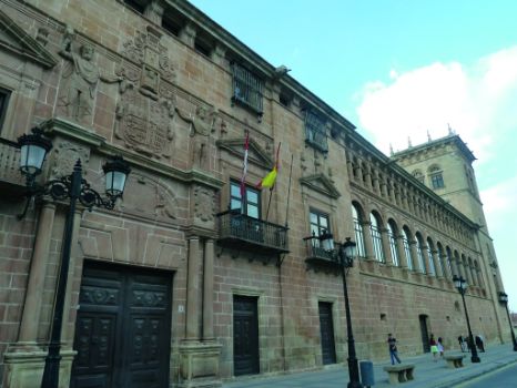
Soria's Puente de Piedra on the River Duero is the unique starting point of this Stage. Venturing through Paseo del Postiguillo, a genuine green tunnel of trees, it continues down Paseo de San Prudencio, where the Museum of Water is located. This museum, housed in a traditional Sorian windmill with the original machinery, explains the different uses of water throughout the history of Soria via panels and audiovisual media.

The route continues along Senda de los Pescadores, past a large recreational area with picnic tables and a playground, and near the Lavadero de Lanas building. From here, one can enjoy views of the Puente de Hierro, built in 1929 for the Santander-Mediterranean railroad.
The riparian vegetation along the promenade consists of English poplars (Populus nigra), ashes (Fraxinus angustifolia), white willows (Salix alba) and birches (Betula pendula), aquatic plants such as cattails and bulrushes (Typha sp.), and numerous shrubs and bushes..
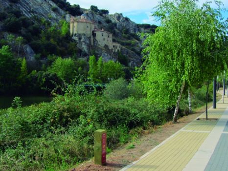
Past the Puente de Hierro, the Shrine of San Saturio appears unexpectedly. The route crosses a bridge to the opposite bank, approaching the shrine that stands on a rocky promontory overlooking the River Duero. The walk to the shrine, one of the most romantic of Soria, inspired the poet Antonio Machado, who mentions it several times in his poetry.
The route continues up along a pedestrian promenade, with a good view of the River Duero and the limestone cliffs that flank its course. Past a car park, the route continues along a farm road through the river valley. Bushes and grass blanket what must once have been fertile market gardens with perfectly aligned rows of zucchini, tomatoes, beans and onions.
Close to some ruins, a sign indicates a turn to the left onto a path that crosses over a small stream. There is short but steep slope that will undoubtedly tire one out. This stretch is unsuited for cycling; it should be walked.

The slope leads to a Castilian plain, where riparian landscape gives way to holm oaks (Quercus ilex) and farms.
The path continues to a crossroads where several houses and industrial buildings stand, and then heads southwest along a farm road on the left. The route climbs gently, surrounded by holm oaks, and a few scattered maritime or black pines (Pinus pinaster), rockrose (Cistus sp.) and heather (Erica sp.).
At the top, the trail divides into two and continues to the right, where it narrows and becomes a track. It zigzags down the slope through lichen-covered holm oaks, with most of the ground covered by bearberry (Arctostaphylos uva-ursi). Despite the strong sunlight, aromatic herbs manage to survive in this terrain.
The path merges with a forest track with signs indicating the way to the town of Los Rábanos. A charming washing house stands next to the edge of the village. From here, the route passes next to a church, and leaves the village through housing development with villas and the municipal swimming pools, next to a large roundabout.
The route continues about 4 kilometres to Lubia, along the old national road N-111 from Soria to Medinaceli. Caution should be exercised here.
The road suddenly turns sharply to the left and ventures through a farm road wedged between fields of grain. Farms soon give way to black pine forests, where animals, such as deer (Cervus elaphus), live and find shelter.
One can also find prized, orange-coloured chanterelle (Lactarius deliciosus) under these pine trees. Many pine forests are included in the MYAS project, which seeks to implement a sustainable development and management model for mycological resources, in order to preserve their habitats, control marketing and create quality mycological tourism.
This road leads to the town of Tardajos de Duero, from where it continues south towards Miranda de Duero. At the first interStage, the road veers left, and after about 80 metres, turns onto a farm road on the right.
The farmsteads that line the Trail offer a beautiful snapshot at dusk, with the wheat in the fields swaying in the wind. The derelict adobe "tenadas" (pens) along the route serve as a reminder of the livestock past of the region, where large herds of sheep used to feed on stubble in August.
After climbing up a small hill covered with black pines, the final stretch of this Stage and the River Duero flanked by its riparian forest become visible. There are two interStages ahead. The route turns right at the first, ventures through a Pyrenean oak forest (Quercus pyrenaica), and then turns left.
In the final stretch of the Stage, Pyrenean oaks and fields of cereal and sunflower escort the traveller until Ituero, where the River Duero and the route meet again. There is a small recreational area next to the river, at the edge of the town, where one can enjoy a well-earned rest.
Sites of interest
Profile

Highlights
Further information
Shrine of San Saturio
The octagonal shrine, typical of the Templars, sits where the Church of San Miguel de la Peña used to stand, which, in turn, was built over Peñalba Grotto. According to tradition, this cave was the home of San Saturio, the Visigoth hermit, and patron saint of the city. He was the son of a 5th century aristocrat family, canonised for giving all his possessions to the needy.
The current temple was built in the late seventeenth century, in the Baroque period. Although the architecture is sober, the temple boasts stunning frescoes that depict the life of San Saturio. It is also home to several medieval images of interest, including two Gothic statues: one of the crucified Christ and another of the Madonna and Child.
The shrine is accessed through the cave at the base. The first room is the meeting room of the Cabildo de los Heroes, a sort of Water Tribunal where the farmers’ guild met. Next to this room is San Miguel's oratory, where San Saturio placed a small altar to San Miguel Arcángel vanquishing the devil. The saint appears in sculpture and paintings in various rooms. A stair attached to the rock leads to two chapter rooms with balconies that offer stunning views of the River Duero.
Wash houses
Wash houses were one of the busiest places in town before running water in houses was common. It was the social focal point of village life, where women exchanged the latest news while they washed clothes.
Several stone basins were used to wash and rinse clothes. Soap was made at home using leftover oils and fats from the slaughter of animals, to which caustic soda was carefully added. The sun would dry and bleach the clothes that hanged on long clotheslines.


