Net of Natural
Trails

Stage 20: Pereruela - Moral de Sayago
Description
The Miranda Road
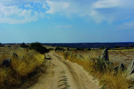
The entire route runs along the Miranda or Mirandesa Roman road through holm oak dehesas. The dehesa is a Mediterranean forest system with centenarian holm oaks and vast pastures used in semi-extensive livestock farming. Granite outcrops and stone walls also grace the landscape of this Stage.
The Stage leaves the town of Pereruela traversing through a plain where cereals grow. The route heads west along the Calzada Mirandesa (Mirandesa Road), which is initially a wide and well-maintained farm road. However, it soon becomes a narrower, dirt road. This old Roman road linked Zamora and Miranda do Duero.

The route crosses Pozarones Brook at the edge of town, and then heads through rain-fed farms and grazing lands towards holm oak dehesas that will soon dominate the landscape.
At a fork, it continues left along the Mirandesa Road. Shortly after, one can see farms graced with rocky outcrops and scattered oaks, some of which are bounded by rudimentary walls or boundary stones.
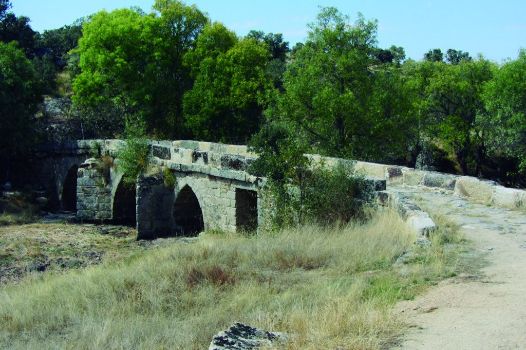
There is a recreational area next to Urrietas Bridge, built with stones on the Sobradillo Creek. It is here that the landscape begins to change, with increasing numbers of holm oaks, rocky outcrops shaped like granite boulders and steeper terrain.

The Trail ventures forth into Dehesa de la Viñuela, where holm oak dehesas alternate with grazing lands on the flood plain. This is a typical Mediterranean landscape shaped by livestock. The dehesas are vast grasslands in which the dominant tree species is holm oak. The remaining terrain is covered by pasture and/or scrub, where livestock graze and shape the landscape. The dehesas have a rich botanical diversity. Its grazing lands have high nutrient value for livestock.
In the upper reaches, the road is narrower and in a poorer state as the quality of the soil worsens. The terrain is overtaken by brooms and oak regrowths due to less grazing. There are also numerous stone walls, which serve as boundary markers for farms and limit the movement of livestock.
The route passes near the town of Arcillo, nestled in the oak forest, a clear example of a County Sayago village. The route joins again the Mirandesa Road.

This area is dotted with farms bounded by stone walls that delimit the small meadows where the livestock owned by the local inhabitants were kept.
The path climbs up, then down a small hill to the River Fadoncino, which is crossed by the charming, Roman-medieval Albañeza Bridge. The ashes (Fraxinus angustifolia) that flank the route bring diversity to the landscape.
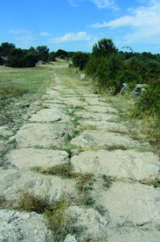
The path climbs up again. One can now see Pyrenean oaks (Quercus pyrenaica), which flourish in the cooler, wetter soils. One can occasionally see traces of the Roman road.
As the path begins to climb down, it traverses through an area where holm oaks intermingle with olive trees, in order to obtain a higher yield from the land. The path passes through a lush tunnel of centenarian oaks, offering a pleasant walk to Casa de Albañeza, a farm with its own shrine.

The Trail continues across Albañeza dehesa, a more open terrain than the one traversed thus far. However, the landscape remains unchanged: holm oak dehesas, grazing lands, varying terrain, stone walls and many granite outcrops. Before reaching Abelón, the next milestone, the route passes near an impressive stone cross. Just before reaching this town, one can see the only remains of the Mirandesa Road that are open to the public.
The route divides the village into two districts. One can enjoy here the essence of a Sayago village and its rural environment.
Although the path continues through an area dominated by grazing lands enclosed by stone walls with holm oaks growing nearby, there are also vast pastures. The landscape throughout this Stage is varied and attractive to walkers and cyclist. Roman remains can be found across the area, with the Roman road being a good example.
Shortly before reaching the road leading to Villalcampo Dam, the oak forest opens into farmland, suggesting the presence of a town. After crossing the road, amidst oaks and ashes, the route arrives at Moral de Sayago, where the Stage ends. The Roman footprint is writ large here where the Mirandesa Road crossed path with the road linking Sayago with counties Pan and Alba. The Concejo Fountain, with a gabled roof and a semi-circular arch, or the steles on the walls of some houses are but two examples.
Sites of interest
Profile


