Net of Natural
Trails

Stage 17: Castronuño - Toro
Description
Pampered fields: Irrigation
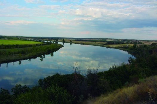
The Almendros Route runs through the typical landscape of Riberas de Castronuño Nature Reserve, where almond trees, bird observatories and the River Duero take centre stage. Past San José Dam, the route ventures into the fertile valley of the River Duero, where pampered, irrigated farms produce bountiful harvests of alfalfa, corn and beet. The final stretch of the Stage leads to the beautiful town of Toro, which looms on the horizon atop a natural balcony.
This Stage, in which the route leaves behind the province of Valladolid to venture into Zamora, starts at the upper edge of Castronuño, near the 13th century Romanesque church of Santa María del Castillo and the Casa de la Reserva, an interpretation centre. The broad horizon offers a sweeping view of the River Duero and San José Dam, located within the Riberas de Castronuño Natural Reserve, where a rich variety of bird species breed, shelter and winter.

This Stage initially overlaps with the Almendros Route, a short route near Castronuño that runs along the Duero, amidst ancient almond trees. The route climbs down from "Muela", where the town is located, and initially overlaps with the former Senda de los Pescadores (a path traditionally used by anglers to climb up from the small pier where their boats are tied).
The path is well laid out with walkways, steps on the steeper slopes, and a viewpoint over the river (Mirador del Teso). After crossing Puente Creek, the path arrives at the pier with an observatory from where one can discreetly watch birds.
The route continues along the narrow path mentioned in the previous Stage, i.e. the path to San José Dam that runs between the wooden guardrail and poplars.
Past the dam, the path reaches a large bathing area with a car park. Caution should be exercised here, as the route runs along county road 112 until the first interStage, where it takes the right path to Canal de San José, traversing through irrigated farmlands, mainly under alfalfa and corn. As the path approaches the Duero, one can see that the riparian vegetation along the river primarily consists of poplars (Populus alba).

The path reaches Villafranca de Duero and heads north out of the town, crosses the Canal, and continues along a paved farm road that runs through the River Duero Valley. The landscape is dominated by irrigated crops, always with the River Duero and its riparian forest nearby. A few farmed poplar plantations break the homogeneous landscape.
The paved road ends soon after, and becomes an easy, flat gravel path. In this stretch, the River Duero makes a large meander that brings the river close to the route, from where the water can be seen. A sign indicates a right turn at the crossroads, next to a small pine stand to the right.
The Trail runs parallel to the River Duero, and reaches Caserío de Tímulos, where a charming, circular dovecote stands on a small rocky outcrop, in an otherwise flat terrain. The route traverses the village and heads north alongside Canal de San José, from which it drifts away soon after to venture into a stone pine forest (Pinus pinea).

Toro Dam is nearby. A small walkway on the right gives access to a bird observatory where one can stop to relax and refresh.
Back on the path, the route runs through a mosaic of alternating pine stands and irrigated farmlands, dotted with a few rain-fed farms. A gravel pit signals the proximity of a more humanised area. At the crossroads with another farm road, the path turns right to continue along a road, with a housing development to the right.
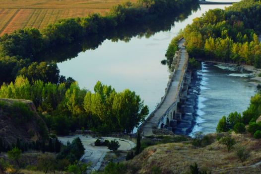
The town of Toro, where the Stage ends, can be seen from here, perched atop a hill above the river. The Trail runs between the road and the River Duero, which escorts the route in this final stretch. The road gradually drifts away from the route, as the path ventures through poplars and other riparian trees towards Mayor de Toro Bridge, of Romanesque-medieval origin, that crosses the River Duero, at the foot of this beautiful Zamoran town. It is not uncommon to see anglers stationed on the bridge casting their fishing poles.
This relaxed Stage ends at a recreational area next to the bridge, below the houses of this town.
Sites of interest
Profile

Highlights
Further information
Toro
The town of Toro has a rich cultural heritage, including the remains of the defensive walls, several Mudejar churches, the monasteries of Santa Sophia and Sancti Spiritus, the bullring and the Arco del Reloj Tower. As legend has it, the mortar used to build the tower was blended with wine instead of water because it was more affordable than transporting the water from the river. The Carnaval de Toro, also of cultural interest, was one of few festivals that Franco's dictatorship did not ban.
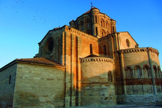
The most outstanding building of cultural interest in Toro is without doubt the Collegiate Church of Santa María la Mayor, inspired by the Cathedral of Zamora. It is a typical transitional Romanesque religious building, dating back to the 12th century.
The construction took decades to be completed (13th c.). Indeed, it was built in two phases. The side façades, walls and general structures were built in the first phase, whilst the roof, dome and buttressed towers were constructed in the second.
The first master mason built the structure in limestone using highly innovative construction techniques for the time. However, the second master mason used an older building style with reddish sandstone as base material.


