
Net of Nature
Trails

Stage 9.1: Puente de Valdecastro - Cillaperlata
Description
To the south of the Cillaperlata reservoir
From the Valdecastro bridge, the final section of the Horadada Gorge and stage 8, one kilometre from Trespaderne, the Ebro Nature Trail continues along the road leading to Cillaperlata, leaving on the left the access to a recreation area by the river, with tables and a barbecue.
This stage begins at the Valdecastro bridge. After one kilometre, the route leaves the road and takes a track on the left, which later turns right and becomes an inland path, along which the GR 99 and GR 85 meet on their route towards the municipality of Frías.

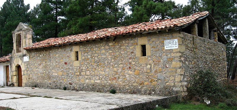
You will first walk among pines and some gall oaks and, after about five minutes, a detour leads you to Encinillas hermitage, a vernacular building that stands out amid a pleasant pine forest, where you can stop to rest and recharge your batteries, as it has several tables and even a fire pit. This is an ideal, mysterious place, owing to the legend of the Battle of the Black Day, where you can spend a good day in the countryside.
Back on the path, the GR 99 comes to an area of fields, some still in use and others reforested with small pine projects, which are clearer of vegetation.
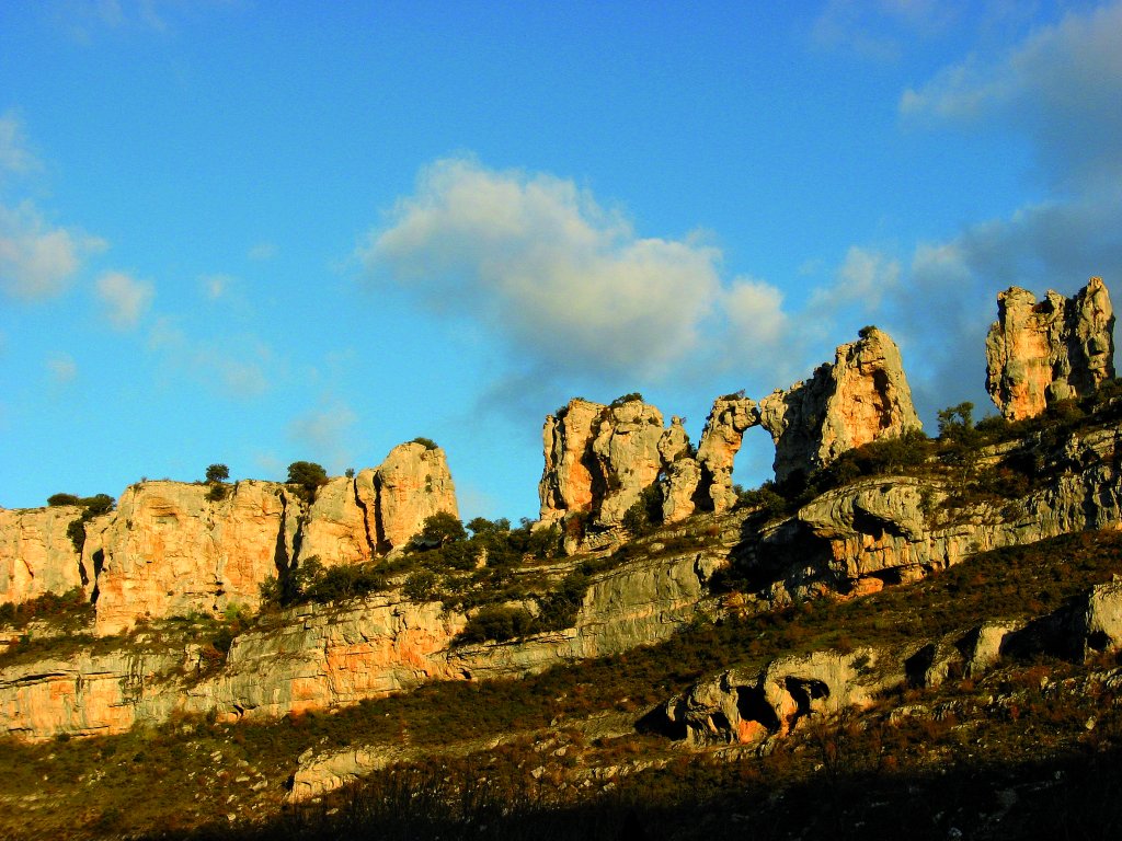
The route thus approaches the Ebro riverbed and runs parallel to it, with the Hoz gorge facing Cillaperlata and the abundant riverside vegetation visible at all times.

On both sides, dotted with holm oaks, pines and gall oaks, the Peña de la Cruz rises on the right to a height of 641 m and, on the left, the Castrillo, at 584 m. The route thus reaches the bend that begins to accumulate water from the Cillaperlata reservoir.
Continuing at a good pace, it will take you barely an hour to reach the road, which leads up to the town and, for about thirty metres, you walk along it until, on the left, there is a path among fields, which leads walkers back to the banks of the river and, later, to the reservoir. From this point on, the journey will be accompanied by a riverside forest offering a good panoramic view of the village, especially with its dam construction, which gives way to the water of the Central Quintana canal. You will reach Cillaperlata at its washing place, where it meets stage 9,joining Trespaderne and Quintana Martín Galíndez.
Sites of interest
Profile

 Harshness of natural environment
- 1. The environment is not risk-free
- 2. There are more than one risk factors
- 3. There are various risk factors
- 4. There are quite a lot of risk factors
- 5. There are many risk factors
 Guidance along the route
- 1. Well defined trails and crossings
- 2. There is a clearly marked trail and signage
- 3. Requires the identification of geographic features and cardinal points
- 4. Requires off-path navigation
- 5. The trail is interrupted by obstacles that have to be gone around
 Route difficulty
- 1. Walking on a flat surface
- 2. Trails with different types of path
- 3. Walking on stepped paths or irregular terrain
- 4. The use of hands or jumping over the terrain is necessary
- 5. The use of hands is required to progress
 Amount of effort needed
- 1. Up to 1 hour of continuous walking
- 2. Between 1 and 3 hours of continuous walking
- 3. Between 3 and 6 hours of continuous walking
- 4. Between 6 and 10 hours of actual walking
- 5. More than 10 hours of continuous walking
(Calculated according to the MIDE criteria for an average excursionist with a light load)
Highlights
Further information
Ebro in the Highlands
Before carving out the great valley, the Ebro rises as a mountain river that frequently races through precipitous gorges. In the wasteland of La Lora, between Valdelomar and Bricias (Cantabria), the river's horizon is formed by the slopes of a steep-faced cliff with karst pools like the Tobazo waterfall.
Further on, in Hoces del Alto Ebro y Rudrón Nature Reserve, these watercourses have cut deep canyons of up to 200 m, where the ochre of the terrain contrasts with the abundant, diverse green vegetation. The elongated Tesla Mountain Range, which separates Medina de Pomar from Valdivieso Valley, is perforated twice by the Ebro: at Hocinos Gorge and Horadada Mountain Pass. This is also the case of Montes Obarenes Nature Reserve, a limestone wall of the Cantabrian Mountains overlooking the lands of Burgos, with deep gorges similar to those carved out by the Ebro in Sobrón.
Finally, in La Rioja, the river has cut an impressive natural channel, Conchas de Haro, that rises to an altitude of 445 m. This channel overlooks Riscos de Bilibio, which gets its name from the Latin word bilibium, meaning two lips. From here, the Ebro abandons the highlands and ventures into the depression in its middle section. Gone are the mountainous areas and uneven geography.
Multimedia


Downloads

GPS Downloads


