
Net of Nature
Trails

Stage 4: Polientes - Orbaneja del Castillo
Description
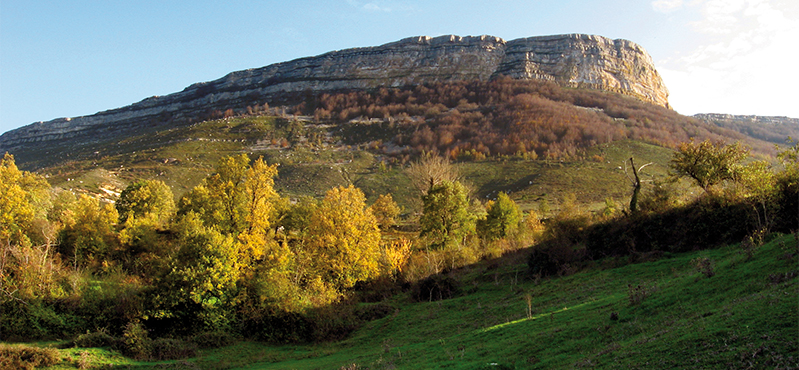
The Ebro flows into the rocky outcrops of El Tobazo
From Polientes, the Ebro Nature Trail continues to Arenillas de Ebro and San Martín de Elines, both of which have beautiful Romanesque temples, before approaching the spectacular Ebro canyon, near Villaescusa de Ebro, which is renowned for its unaltered vernacular architecture. Amidst beech and poplar trees, the Ebro narrows between the rocky outcrops at Electra del Tobazo, a former power station from where you can access the beautiful El Tobazo waterfall and its caves. Presently it continues in Burgos, to Orbaneja, a village that combines urban appeal with a spectacular natural landscape, with sites such as the whimsical El Castillo rock formations and its numerous caves.
It starts out at the rest area beside the Rocamundo bridge. After crossing the river, you enter a track amidst fields and gall oaks that ends at a farm with beehives, by now on La Mata de Arenillas hill. When the vegetation begins to thin out, the path affords views of Ruijas, on the other side of the Ebro.

The dirt track now becomes asphalted just outside Arenillas de Ebro. After crossing the village, you turn off it beside the 12th century Romanesque church of Nuestra Señora de la Asunción. Follow the road to Villota de Elines, 1.5 km away. You then leave the village, taking a dirt track that begins beside the church and heads towards San Martín de Elines, first among pastureland and crop field and then among gall oaks.
If you have enough time, you can visit the collegiate church of San Martín de Elines in the village square. It was originally a 10th century Benedictine monastery with Mozarabic influences. Its Romanesque church was built in the 12th century. The cloister, which houses beautifully-carved 16th century sarcophagi. The exterior is stately: a circular tower and a set of marvellous corbels.
The route then follows a path that leads down to the river and to Barrio de Abajo, with good views of San Martín de Elines and its collegiate church, the moorland of La Lora and Arroyuelos. The Nature Trail continues straight, leaving the bridge over the Ebro on the left leading to Arroyuelos, passing a washing place. The route approaches the spectacular Ebro canyon, whose presence can be intuited by the narrowness of the walls enclosing it. From the path you can see the last foothills of the La Lora moor, and fields with cattle and horses. Continuing along the route, you will enter a gall oak grove, which also contains beech trees.

The route leaves behind an abandoned religious building before reaching Villaescusa de Ebro and its bridge. The site is divided into two neighbourhoods linked by an asphalted road on the right bank of the Ebro. Its church is simple and vernacular, but its architecture is among the most interesting and unaltered churches in Valderredible. In the second neighbourhood, you will continue to cross fields and walls, before entering, after an extensive crop field, an area of gall oaks, beeches and black poplars where the Ebro narrows between the rocky outcrops.
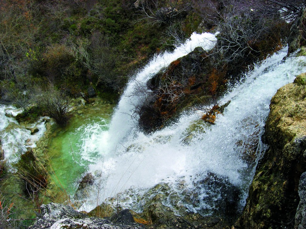
At this point, you can leave the path for a moment to take a simple path to the El Tobazo waterfall. Apart from the waterfall, the karstic nature of these lands means that the carbonate-saturated waters have created a curious geological formation.
On the way back to the Nature Trail, after fording a stream on a concrete bridge, you will reach the Electra del Tobazo power station, where the track ends. Leaving the facility on the left and after going around it, continue on the right bank of the Ebro, along the old road to Orbaneja, through a landscape that combines pedunculate oaks, riverside vegetation and the rocky outcrops that demarcate the river.

After crossing the Vertiente de Cabeza de Pedro stream, the route crosses the Cantabria-Castile and Leon border, entering Burgos. The vegetation soon becomes denser, with holly bushes, pedunculate oaks and a small wetland near a restored pine forest rich in protected bird life.
After crossing the Vertiente de Cabeza de Pedro stream, the route crosses the Cantabria-Castile and Leon border, entering Burgos. The vegetation soon becomes denser, with holly bushes, pedunculate oaks and a small wetland near a restored pine forest rich in protected bird life. At the end of the second meander, a bridle path, leading from the moor, joins the path that runs away from the river and climbs up after leaving behind some magnificent pedunculate oaks. It thus approaches the whimsical rock formations of El Castillo, which gives Orbaneja the second part of its name.
Travellers will be aware here that the vegetation is less dense and the landscape is more open, with the village of Orbaneja del Castillo, the end of the stage, in sight; the centre of the village is reached after crossing a bridge leading to the road. The combination of its spectacular natural landscapes and its popular character make it one of the most beautiful places in the north of Spain: limestone streets, houses with a mountain influence, a Romanesque church, and the karstic complex, with caves that grow in the dolomitic limestone of the Middle Turonian, such as the El Agua, El Barbancho and El Níspero caves. At the end of the second meander, a bridle path, leading from the moor, joins the path that runs away from the river and climbs up after leaving behind some magnificent pedunculate oaks. It thus approaches the whimsical rock formations of El Castillo, which gives Orbaneja the second part of its name.
Travellers will be aware here that the vegetation is less dense and the landscape is more open, with the village of Orbaneja del Castillo, the end of the stage, in sight; the centre of the village is reached after crossing a bridge leading to the road. The combination of its spectacular natural landscapes and its popular character make it one of the most beautiful places in the north of Spain: limestone streets, houses with a mountain influence, a Romanesque church, and the karstic complex, with caves that grow in the dolomitic limestone of the Middle Turonian, such as the El Agua, El Barbancho and El Níspero caves.
Entidades gestoras:
- Ministerio de Agricultura, Pesca y Alimentación
Enlaces de interés
Puntos de interés
Culture
Geology
Infrastructure
Municipality
Orography
Profile

 Harshness of natural environment
- 1. The environment is not risk-free
- 2. There are more than one risk factors
- 3. There are various risk factors
- 4. There are quite a lot of risk factors
- 5. There are many risk factors
 Guidance along the route
- 1. Well defined trails and crossings
- 2. There is a clearly marked trail and signage
- 3. Requires the identification of geographic features and cardinal points
- 4. Requires off-path navigation
- 5. The trail is interrupted by obstacles that have to be gone around
 Route difficulty
- 1. Walking on a flat surface
- 2. Trails with different types of path
- 3. Walking on stepped paths or irregular terrain
- 4. The use of hands or jumping over the terrain is necessary
- 5. The use of hands is required to progress
 Amount of effort needed
- 1. Up to 1 hour of continuous walking
- 2. Between 1 and 3 hours of continuous walking
- 3. Between 3 and 6 hours of continuous walking
- 4. Between 6 and 10 hours of actual walking
- 5. More than 10 hours of continuous walking
(Calculated according to the MIDE criteria for an average excursionist with a light load)
Highlights
Further information
El Tobazo
Before reaching Electra del Tobazo, a path leads to the beautiful El Tobazo waterfall. The path climbs up a field to the base of the waterfall, and further on to the top. Erosion has carved numerous natural caves into this karst outcrop of tufa stone, which have been used as a hermitic retreat. At the very top is the pool from where the water spills over the waterfall.
Electra de Tobazo used this hydraulic power to light and supply water to the town of Valderredible. Now a privately owned property, it has been 25 years since it was last used for that purpose.
Multimedia


Downloads

GPS Downloads


