Net of Natural
Trails

Stage 39: Móra d'Ebre - Benifallet
Description
Through the Benissanet and Benifallet orchards
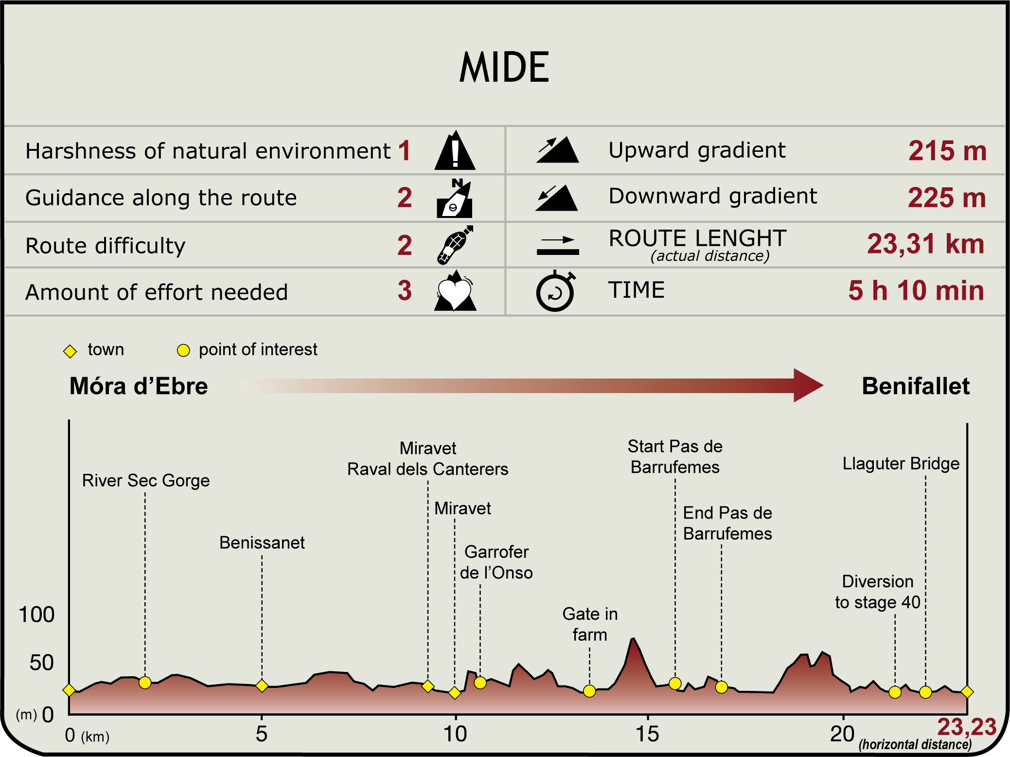
Starting from the municipality of Móra d’Ebre, the Sènies path will guide hikers to the fertile orchard of Benissanet and the monumental centre of Miravet. Besides its natural environment, this village contains the ruins of its Knights Templar castle, in one of the iconic images of the lower course of the Ebro. This is the end of the plain and the beginning of a steep section which approaches the final foothills of the Catalan Coastal Range. For its part, the Barrufemes Pass gorge enables you to flank the river over a vertical wall and so reach Benifallet, after crossing to the left bank over the Llaguter bridge amidst a landscape of orange and fruit trees.

After leaving Móra d’Ebre and taking the road that goes under the arch of the bridge, turn right, taking the Sènies path, which immediately crosses under the new N-420 bridge.
Continue southwards and, after crossing the River Sec gorge, among farmhouses and waterwheels on both sides, make two 90º turns (the first to the left and the second to the right), which will allow the traveller to reach the village of Benissanet. From this point, head towards Miravet on the T-324 road, leaving behind a small square with a crossroads.
Before reaching this village you will reach the Raval dels Canterers. There, after a slight bend in the urban through road, take the street on the left, which gives access to the fields and allows you to skirt the new part of the village. This leads to the riverbank in the Plaza de Arenal, under historic centre of Miravet. It is now time to leave this ancient town; to do so, go up, from the esplanade of the riverbank, along carrer del Forn until you reach the church square. On one side, an alleyway beside the parish church leads to the Sanaqueta viewpoint, although the nature trail heads south-west along a cobbled street which immediately begins a pronounced descent.

After descending the Costera de Riago and a few metres on the flat, you will reach a crossroads overlooked by an old carob tree, known as the Garrofer de l’Onso, where a path begins, on the right-hand side, which climbs up to the castle. Further on, the path becomes a track and climbs up until it reaches a crossroads. On the left, on a paved path, you will traverse a cultivated hollow and approach a promontory near the river. It is time to take a breath of fresh air and enjoy the magnificent views of the river, before beginning the descent and reaching the sliding gate of a farm which, because it is a public path, will always be open to hikers.
Within the farm, the old Miravet to Benifallet path is almost always a service road for the farm itself. There is only a short 400-metre section to be walked along a path that has been reclaimed from the mountain, which climbs up to a gentle hill and then descends again among mandarin trees to the Ebro plain itself.
At the limits of the farm, there the river hugs close to the rocky hillside, the trail again becomes a path before crossing the Pas de Barrufemes or Roca Folletera.

On this rocky wall, which falls vertically into the waters of the Ebro, the path opens, clinging to the bank, under a sizeable tree-lined bank. Poplars, willows and reeds accompany the hiker until it ends on the track leading to the first fields in the Benifallet orchard.
From this point on, continue among fields of orange trees, crossing this narrow strip of land that the Ebro allows in its entrenchment. You then cross the Les Murtes gorge and the path is then paved with asphalt, which makes it easier to rise to a greater height. Finally, you leave behind a crossroads from which you can already seen Benifallet and where you take the road on the right. From here the path reaches the hard shoulder of the C-12 road, beside the Llaguter bridge which, once crossed, leads to the village of Benifallet.
Sites of interest
Puntos de interés
Culture
Municipality
Hostel
Passport
Profile

Highlights
Further information
Miravet, Benissanet and Benifallet
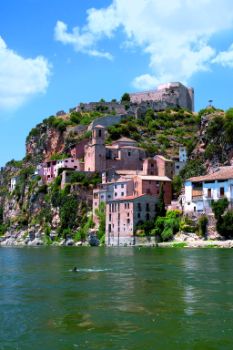
Miravet is dominated by the imposing castle, which was built by Muslims and Knights Templar, and is located 300 m above the river. Its municipal area also extends along the left bank of the river, so there is a platform (for towboats) for people and vehicles to cross the river. The scenic beauty that combines the expanse of the deep river and the backdrop enclosed by the rocky mass, crowned by the medieval castle and over which the old quarter of Miravet spreads, is embodied in one of the iconic spots of the lower course of the Ebro.
The names Benissanet and Benifallet are of Arabic origin. Benissanet is a village in the centre of the extensive irrigated plain overlooking the conical roof of Mora Castle. It cultivates peaches and has an interesting museum of musical instruments. Benifallet is also concerned in intensive growing of fruit trees, especially orange trees. Within the village you can visit the Cova de les Meravelles, the Iberian village of Roca Roja and Cardó spa.
Navigation on the Ebro
Over the centuries, all of the peoples and cultures who have inhabited the banks of the Ebro have navigated it. Iberians, Greeks, Romans, Muslims and medieval Christians used its waters to trade and travel, to battle and to dominate the land, making it the region’s main means of communication. The Ebro, like a great living river, has continuously changed its shape.
Nature, with its periodic floods, and by the hand of man, with the construction of hydraulic works over the course, have created an irregular flow rate, with major floods, prolonged low water levels and a changing riverbed, which is not always suitable for navigation. Thus, although the Greeks managed to sail from the Ebro Delta to Varea (beside Logroño), installing there a major river port, shorter routes were commoner, since long-distance transport could barely reach Zaragoza.
There were various serious attempts at navigation to promote trade and passenger transport, using not only the river bed itself, but also by building major, wide parallel canals, such as the Canal Imperial de Aragón, from near Tudela to Fuentes de Ebro; and the canal on the right bank of the Ebro, which from Xerta sought the convenient river port of Sant Carles de la Ràpita. However, the arrival of the railway, other improvements to the road network, as well as the construction of large dams and reservoirs, ensured that any attempt to navigate the Ebro on a large scale would be permanently abandoned.
Traditional vessels
Traditionally, small boats in the Catalan-speaking area as llaüts, were used, which could carry loads of up to 30 tonnes. Downstream, they were carried by the river itself; upstream, they were rowed, with the wind when it was favourable and the captain skilful, or using a towrope pulled from the bank by men or, later, by a mule. From Escatrón to Tortosa, coal, cereals, salt, wool, leather, saffron and horses were transported; from Tortosa to Escatrón, from Barcelona, spices, sugar, fine fabrics, dyes and furniture were moved. Wood was also carried in spring from the bordering mountains to Tortosa, where it was transported by joining the trunks until a raft was formed (known in Aragonese as nabatas and in Catalan as rais).


