
Net of Nature
Trails

Stage 3: Villanueva de la Nía - Polientes
Description
Valderredible lands
The route leaves the valley of the Mardancho stream and climbs up a track among gall oaks to Casallo hill; it then descends to the east amid the Castill hill gall oak grove and continues through several of the small but interesting villages that make up the municipality of Valderredible, including Sobrepenilla, which has the Romanesque church of San Martín, and Rebollar de Ebro, where it is worth taking a detour to visit Santa María hermitage. After crossing the Ebro over the Rocamundo bridge, you will finally arrive at Polientes, the capital of Valderredible, which has outstanding examples of civil architecture and an ethnographic museum offering insight into the history and traditions of the area.
Before leaving Villanueva de la Nía, it is worth making a visit to the Romanesque church of San Juan Bautista, with 12th century apse, which is related to the Cervatos school due to its corbels with sexual motifs. It is also recommended that you visit a necropolis of anthropomorphic tombs, enjoy the mountain architecture, with its semicircular arched doorways and sun terraces or visit the Way of the Cross to the Virgen del Monte hermitage.
The path begins by crossing the Mardancho stream, then takes a track that starts from the east of the village among gall oaks on the La Nía hill, with views of Cubillo de Ebro. After crossing a farm where you will have to go through two wickets and cross the Arrocastro stream, the route heads into the province of Plasencia for the next 5 km. You will then continue the ascent to Casallo hill, from where you can enjoy beautiful views over Berzosilla and the sierra. After reaching the top of the Castillo pass, you will descend eastwards through the gall oak grove on Castillo hill, which leads to Cuillas del Valle. You will leave behind this village and follow the road towards Olleros de Paredes Rubias, via an old bridle path that goes through a pasture area and the old fountain. The surviving medieval kilns and the name Olleros de Paredes Rubias recall the pottery that was made there. Its vernacular architecture and the Gothic church of San Juan Bautista stand out.

Without reaching Olleros, the path deviates to the east, first through flat terrain among fields and then among gall oaks, before re-entering Cantabria and reaching Sobrepenilla. At the end of the houses in this village, beside the 13th century Romanesque church of San Martín, which is notable for its belfry, porch and beautiful windows in the flat apse and the south side, there is a road that you will immediately leave. To do so, it uses a path on the left that, among gall oaks, pastureland and crops, leads to Sobrepeña, offering views towards Montecillo, Quintanilla de An and Campo de Ebro and other landscapes.
Once you are in Sobrepeña, it is worth visiting the church of Santa Juliana, which, according to its façade, dates to 1567 and has an aisle and belfry at the foot offering magnificent views. The rural development centre “La Cojura del Ebro” also stands out.

The route leads a few steps along the road before continuing along the old road to Rebollar de Ebro, which begins on the right among gall oaks. The route then meets the road again, which you must cross once more to enter a gall oak grove and an area of fields. The path reaches a grassy esplanade, with the Ebro on the left and the Santa María hermitage in the background. A path on the right leads to the Romanesque building, albeit it has 19th century additions. The church has a nave, a flat apse and a small belfry. The most interesting things, however, are the anthropomorphic tombs carved into the rock. Below it, beside the path, there is a cave sanctuary, the hermitage’s first foundation.
Upon returning to the route, go along the right bank of the Ebro to Rebollar, with its 16th century church of San Vicente. The Gothic construction consists of a belfry, a polygonal apse, a pointed arch doorway and archivolts with spherical decorations under a wooden porch. After crossing the village, you will leave the road and follow a track on the left that leads to a pine forest and climbs up to a small hill.

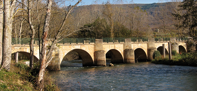
Once at the top, descend towards the river, where the route becomes smoother, with a view of Polientes on the right bank of the Ebro. The path reaches the road that leads to the La Velilla and Rocamundo hermitage on the right, although the route then continues on the left, reaching the Rocamundo-Polinetes bridge and, after crossing the river, the Requejada recreational area.
From here the village of Polientes, the capital of the municipality of Valderredible, is less than 1 km away. The village features good examples of civil architecture, including the 1930s council building, the tourist office and the Ethnographic Museum of Valderredible. This is a place to learn about the history, customs and traditions of the area. Its Environmental Education Centre organises programmes with schoolchildren, raising awareness of the area’s natural and cultural heritage.
Entidades gestoras:
- Ministerio de Agricultura, Pesca y Alimentación
Enlaces de interés
Puntos de interés
Culture
Municipality
Profile

 Harshness of natural environment
- 1. The environment is not risk-free
- 2. There are more than one risk factors
- 3. There are various risk factors
- 4. There are quite a lot of risk factors
- 5. There are many risk factors
 Guidance along the route
- 1. Well defined trails and crossings
- 2. There is a clearly marked trail and signage
- 3. Requires the identification of geographic features and cardinal points
- 4. Requires off-path navigation
- 5. The trail is interrupted by obstacles that have to be gone around
 Route difficulty
- 1. Walking on a flat surface
- 2. Trails with different types of path
- 3. Walking on stepped paths or irregular terrain
- 4. The use of hands or jumping over the terrain is necessary
- 5. The use of hands is required to progress
 Amount of effort needed
- 1. Up to 1 hour of continuous walking
- 2. Between 1 and 3 hours of continuous walking
- 3. Between 3 and 6 hours of continuous walking
- 4. Between 6 and 10 hours of actual walking
- 5. More than 10 hours of continuous walking
(Calculated according to the MIDE criteria for an average excursionist with a light load)
Highlights
Multimedia


Downloads

GPS Downloads


