
Net of Nature
Trails

Stage 2.1: Aldea de Ebro - San Martín de Elines
Description
Surrounding the oak forest of Monte Hijedo
This section of the Nature Trail between Aldea de Ebro to San Martín de Elines offers beautiful views of the surroundings and provides an insight into the economy, way of life, history and architecture of the Cantabrian Mountain villages. However, the main landmark of the stage is the oak forest of Monte Hijedo, one of the largest and most important forests in Europe; a valuable space for its flora and fauna, to which the Riopanero interpretation centre brings us closer. This natural setting is complemented by the valuable medieval heritage preserved in towns such as Ruerrero and San Martín de Elines, the final point of the stage.
The path leaves Aldea de Ebro, heading east on the road to Mediadoro. After about 700 m, an old path starts among Portuguese oaks (Quercus faginea) on the left-hand side that goes down to the Albergue stream. Later, the route climbs along a track, first through dense forest and, after crossing the road that arrives from Aldea de Ebro, then along a clearer stretch, until the fields of Mediadoro
All the way up along the route and from the town itself, the views of Aldea de Ebro are outstanding. To the south, its mountains stand out, covered with beech, Portuguese oak and dwarf mountain pine trees, as well as the land that stretches towards the Ebro reservoir and the Cantabrian Mountain range to the north. Mediadoro is home to interesting mountain style architecture and the parish church of Santa Bárbara, dating from the early modern period.
Leaving the village to the north along a dirt track that heads east towards La Bandurrina, we enter a large area carpeted with high mountain herbaceous vegetation known locally as the alpine tasca. This area is usually grazed by horses and cattle in the summer, giving walkers following this route an insight into the mountain economy.
The track is left after 2.7 km, carrying on along a path that climbs upwards between cattle pastures and some mountain scrubland. The climb culminates next to a pond from where magnificent views of both sides of the mountain can be enjoyed.
The trail continues by crossing over a stile in a fence that marks the boundary between the communities of Cantabria and Castilla y León and, from here, the route enters the forest. For the next 4 km, the trail, which has gone from being a path sometimes indistinct in the grass to a wide track, runs through the province of Burgos.

After a continuous descent through European beech trees (Fagus sylvatica) and sessile oaks (Quercus petraea), there is a clearing and the path that provides access from the north to Monte Hijedo. On the right, the Cabaña de Hijedo is a stone’s throw away. This early 20th century mansion is made up of a house, chapel, and farmhouse, all arranged around a central courtyard where a magnificent specimen of a common yew (Taxus baccata) stands.
The trail leaves the track next to the entrance gate, taking a path that starts on the right and goes back into the thick, lush forest. On this occasion, the beech and oak trees are joined by specimens of holly (Ilex aquifolium), hazel (Corylus avellana) or dogwood (Cornus sanguinea).
The path undergoes a turn of almost 180 degrees and becomes a narrower path that leaves some intriguing sandstone formations on the left and continues descending until it meets the Hijedo stream.
The route follows the river alternating between one bank and the other. On the first four occasions via wooden bridges, but twice later via fords, and although the river is narrow and shallow at these points, care should be taken.
The trail is sometimes completely hidden amongst the vegetation, so the route is indicated by means of red dots painted on trees. The surrounding woodland has morphed into silver birch (Betula pendula) and alder (Alnus glutinosa), although oak, beech, holly, and hazel are still present.
After the last fording of the river, the route reaches a fairly wide track that continues parallel to the stream, along its left bank, for almost 3 km. This track ends, after passing through a small patch of silver fir trees (Abies alba) at the Monte Hijedo refuge.

However, it is still necessary to cross the Hijedo stream once again over a bridge where an asphalted track starts that ascends in the direction of Riopanero. The route moves away from the waterway, and, after a kilometre, Monte Hijedo is left behind for good at the carpark while the views open up to the valley of the Hijedo and Breña streams.
Leaving behind a small hermitage and the old school buildings that nowadays serve as a hostel, the village is approached from the north. The path then changes direction to leave Riopanero to the southwest, just before a beautifully restored medieval building that now houses the Monte Hijedo Visitor Centre – a visit to which provides an insight into forestry heritage of the area, with a special focus on Monte Hijedo.
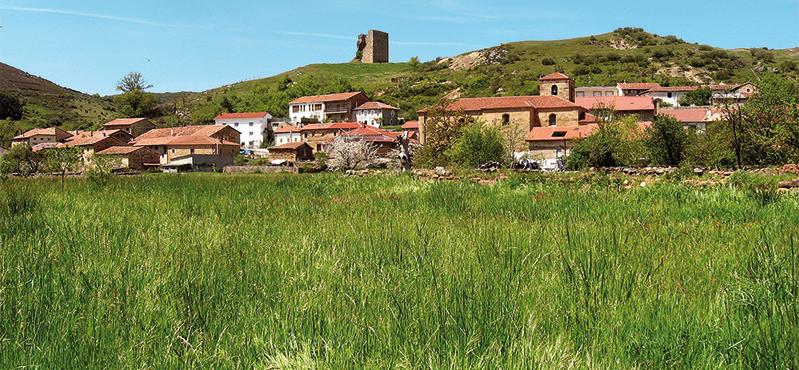
The route then enters a grassy passage flanked by cherry trees, field walls and enormous oak trees that later give way to an area of pastureland that reaches the town of Población de Abajo. The route, which does not pass through its streets, leaves the village along a path, once again through pastures, which goes down to the road to Ruerrero, under the watchful eye of its medieval tower.
A little further on, it is time to cross the road next to the Riopanero mill and then cross the Panero stream over a bridge that allows us to continue along the old road to the village. In addition to the medieval tower, this village also boasts an arcaded square and the church of Nuestra Señora de las Nieves, a construction dating from the 17th century. Before leaving the village behind, we recommend sampling one of its most characteristic products: the exquisite "Valluco" cheese.
Ruerrero is exited on the eastern side, next to the road towards Cadalso, as the path turns off to the left next to some barns and crosses the road towards Repudio. On the other side, a path starts that crosses the San Roque stream and leads uphill beneath the slopes of Monte Cadalso. The landscapes of Valderredible are left behind and the trail approaches Repudio, on the opposite bank of the stream. The path skirts round the mountain and enters a Portuguese oak woodland.
After becoming a track, the trail passes through Santa María de Hito, a small hamlet that houses the beautiful Romanesque chapel of Santa María, with 16th century additions. After crossing the road, the path passes between fields and leads to the road to Villaverde de Hito one kilometre later. This village has beautiful stone architecture, a 12th century Romanesque church and a picnic area where walkers can catch their breath. From the upper part of the village, a track offers great panoramic views of the beginnings of the Ebro canyon to the east and San Martín de Elines to the south.
Finally, the track reaches Arroyuelos, passing by the hermitage of San Acisclo y Santa Victoria. After traversing this hamlet, a road is taken to the south that leads to the Ebro River. The end point of the stage is reached after crossing the bridge over the river, at the meeting point with Stage 4, which is in the Abajo neighbourhood of San Martín de Elines.
Sites of interest
Puntos de interés
Culture
Municipality
Profile

 Harshness of natural environment
- 1. The environment is not risk-free
- 2. There are more than one risk factors
- 3. There are various risk factors
- 4. There are quite a lot of risk factors
- 5. There are many risk factors
 Guidance along the route
- 1. Well defined trails and crossings
- 2. There is a clearly marked trail and signage
- 3. Requires the identification of geographic features and cardinal points
- 4. Requires off-path navigation
- 5. The trail is interrupted by obstacles that have to be gone around
 Route difficulty
- 1. Walking on a flat surface
- 2. Trails with different types of path
- 3. Walking on stepped paths or irregular terrain
- 4. The use of hands or jumping over the terrain is necessary
- 5. The use of hands is required to progress
 Amount of effort needed
- 1. Up to 1 hour of continuous walking
- 2. Between 1 and 3 hours of continuous walking
- 3. Between 3 and 6 hours of continuous walking
- 4. Between 6 and 10 hours of actual walking
- 5. More than 10 hours of continuous walking
(Calculated according to the MIDE criteria for an average excursionist with a light load)
Highlights
Further information
Valderredible and rock-cut architecture
The Cantabrian municipality of Valderredible is home to the highest concentration of rock-cut churches and hermitages in Spain. This area possesses some of the best examples of rock-cut architecture in Spain and has led to the municipality sometimes being called "the Iberian Cappadocia".
This architecture style was born out of the presence of sandstone rock in a large part of the territory. This rock is easy to drill and by excavating and hollowing out pre-existing rock shelters or caves, these places of worship were built and served as a refuge for anchorites and hermits who moved to this location between the 10th and 18th centuries.
Within the municipality, the most outstanding buildings are the church of Cadalso, a simple structure that still holds occasional services and has a graveyard next to it; the hermitage of Arroyuelos, a monumental two-storey building with Mozarabic features and the church of Campo de Ebro. These are joined by the church of Santa María de Valverde, the largest in the municipality. Mass is still celebrated there on a regular basis and there is a graveyard next to which the Interpretation Centre of Rock-Cut Architecture has been set up. Worthy of note is also the hermitage complex of El Tobazo, located on the spring of the same name, at the beginning of the Ebro canyon.
El Monte Hijedo
Monte Hijedo is the most extensive forest mass in Cantabria and the second most in Spain. It extends over an area of approximately 100 km2, between the municipalities of Valderredible (Cantabria), Arija and Alfoz de Santa Gadea (Burgos). Due to its transitional nature being located between two biogeographical areas, Cantabrian and Mediterranean, it represents an area of high ecological value that for several decades has been the focus of several initiatives aimed at its protection and conservation. Monte Hijedo is an excellent mixed forest of sessile oak (Quercus petraea) and beech (Fagus sylvatica), which in addition to containing other oak species, such as Spanish and gall oak, hides in its interior magnificent specimens of centenary common yew (Taxus baccata), holly (Ilex aquifolium) and even some patches of silver fir (Abies alba). In areas close to watercourses birches (Betula pendula), hazelnut trees (Corylus avellana) or alders (Alnus glutinosa) are present.
Its high ecological value has made it a unique haven for a great diversity of species, both flora and fauna. It is home to a large variety of ungulates, including the roe deer (Capreolus capreolus) and wild boar (Sus scrofa) and forest carnivores such as the European pine marten (Martes martes) and the European wild cat (Felis sylvestris). But, above all, it is a true paradise for birds: golden eagle (Aquila chrysaetos), Eurasian goshawk (Accipiter gentilis), Eurasian sparrowhawk (Accipiter nisus), Eurasian eagle-owl (Bubo bubo) and woodpeckers, including the endangered black woodpecker (Dryocopus martius).
The richness of this environment is completed with a rich historical and cultural heritage characterised by the minimal transformation of the natural habitat. Since time immemorial, the inhabitants of this region have lived with the forest, exploiting it in the traditional way, which has allowed it to be preserved until the present day.
Both aspects, environmental and cultural, have turned Monte Hijedo into a key piece of heritage and a resource that we must help to conserve in the future. In Riopanero, the Monte Hijedo Interpretation Centre provides visitors with routes to explore this forest.
Multimedia


Downloads

GPS Downloads

