
Net of Nature
Trails

Stage 1: Fontibre - Montes Claros
Description
The source of the Hiberus flumen
Fontibre is the cradle of the Ebro. From the monument commemorating its source, the route begins at the source of the river, where its interpretation centre is located, and crosses the well-known village of Reinosa and, after passing through villages boasting interesting examples of Romanesque art, such as San Ciprián, Santa María and San Julián, it reaches Montes Claros monastery, a 17th century work with a curious butterfly museum. The scenery over these first few kilometres is impressive, with views such as those you can enjoy from the summit of El Cotío (1,163 m), meadows and the dense oak forest between Bustasur and the Montes Claros halt.
Fontibre (Fontes Iberis, that is, "Fuentes del Ebro", Sources of the Ebro in English), an idyllic natural landscape at an altitude of 885 m and the cradle of the largest river in Spain, is the starting point of the Ebro Nature Trail, which leads to the Mediterranean. The route starts beside the point traditionally considered the source of the Ebro with an ascent to a paved path leading to the CA-183, where a footpath and cycle path have been laid out, leading to Salces and Nestares, 1.4 km further on. Reinosa is then accessed via the San Francisco residence. After crossing the Ebro at Calle Emilio del Valle, the GR enters a park running parallel to the river. The route alternates from one bank to the other until the end of the green zone, beside the level crossing.

On the other side, the path continues by the river, going under the bridges and the A-67, until it reaches Requejo. After heading south, once you have crossed the Ebro, you will walk a little more than 1.5 km along the CA-731 road’s cycle path, before ending up in Bolmir, beside the 12th century Romanesque church of San Ciprián. The Ebro Natural Trail now crosses the road leading to Arroyo and ascends through the fields to Retortillo. In this village, you can visit the Romanesque church of Santa María, which also dates to the 12th century, and the site of the Roman city of Julióbriga and its visitor centre.
Without entering the village, you will have to go through a gate and continue along a track, leaving the water tank on the left and the cemetery on the right, to reach El Apartadero and Camporredondo. From there, a path begins on the left and ascends the mountainside to the summit of El Cotío and, one kilometre further on, reaches Peña Cutral (1,085 m).
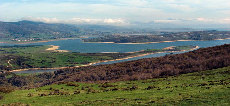
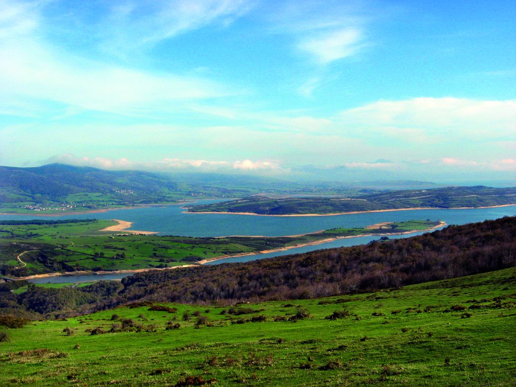
The views are breathtaking from this point: Peña Labra (2,017 m), Pico Tres Mares (2,222 m), Reinosa and the reservoir and meanders of the Ebro. In the background rise the Pasiega mountains, with the Castro Valnera (1,718 m) and the Picón del Fraile (1,648 m). To the south, an immense space stretches towards Valderredible and Castile.
")
The path continues along the ridgeline of the mountain range, a long grassy braña leading to the El Arroyo pass (1,126 m). Once past Peñastrosa, the route descends until it reaches Arroyo. You will then cross the village on the road, observing some 19th century buildings, such as the glass factory, and the Ebro reservoir, which was created in the 20th century.
After the dam, an old road ascends to La Aguilera through a dense oak forest. Once outside the village, you will leave the Romanesque church of San Miguel behind you and take the road from Arroyo. After the last houses, a dirt track leads to a gate on the right that gives access to a farm. After that, you have to descend on a track through grassy fields, with views of the Peña Labra mountain range and the Ebro.

The path leads to a firebreak, which you will have to descend to cross the Morgado stream, before ascending again. After passing it, turn right, southwards, along a track that descends through pastureland and pine trees, over the Tasugueras stream, to Bustasur. Now on the road, the path turns left and passes the Romanesque church of San Julián, a 12th century building, before continuing to a detour on the right that leads down to the bridge over the Ebro.
You will then cross over and follow the path that ascends on the right which, through a dense oak forest, leads to a track that leads you to the Montes Claros halt and, once you have crossed the railway line, an asphalt track leading to the car park and rest area beside the Montes Claros monastery. This monastic complex has a guesthouse, open from May to October, a bar and a museum with a remarkable butterfly collection.
It is possible to continue the route to the next stage without ascending to the Montes Claros Sanctuary by means of a branch track which, from the bridge over the Ebro, runs parallel to the river before reaching a junction with Stage 2.
Sites of interest
Puntos de interés
Culture
Hydrography
Infrastructure
Municipality
Hostel
Profile

 Harshness of natural environment
- 1. The environment is not risk-free
- 2. There are more than one risk factors
- 3. There are various risk factors
- 4. There are quite a lot of risk factors
- 5. There are many risk factors
 Guidance along the route
- 1. Well defined trails and crossings
- 2. There is a clearly marked trail and signage
- 3. Requires the identification of geographic features and cardinal points
- 4. Requires off-path navigation
- 5. The trail is interrupted by obstacles that have to be gone around
 Route difficulty
- 1. Walking on a flat surface
- 2. Trails with different types of path
- 3. Walking on stepped paths or irregular terrain
- 4. The use of hands or jumping over the terrain is necessary
- 5. The use of hands is required to progress
 Amount of effort needed
- 1. Up to 1 hour of continuous walking
- 2. Between 1 and 3 hours of continuous walking
- 3. Between 3 and 6 hours of continuous walking
- 4. Between 6 and 10 hours of actual walking
- 5. More than 10 hours of continuous walking
(Calculated according to the MIDE criteria for an average excursionist with a light load)
Highlights
Multimedia


Downloads

GPS Downloads


