

Net of Nature
Trails

Turia - Cabriel Nature Trail. Jaraguas - Cabriel section
Description
The Natural Park of Hoces del Cabriel, the great final protagonist at all levels of the Nature Trail.
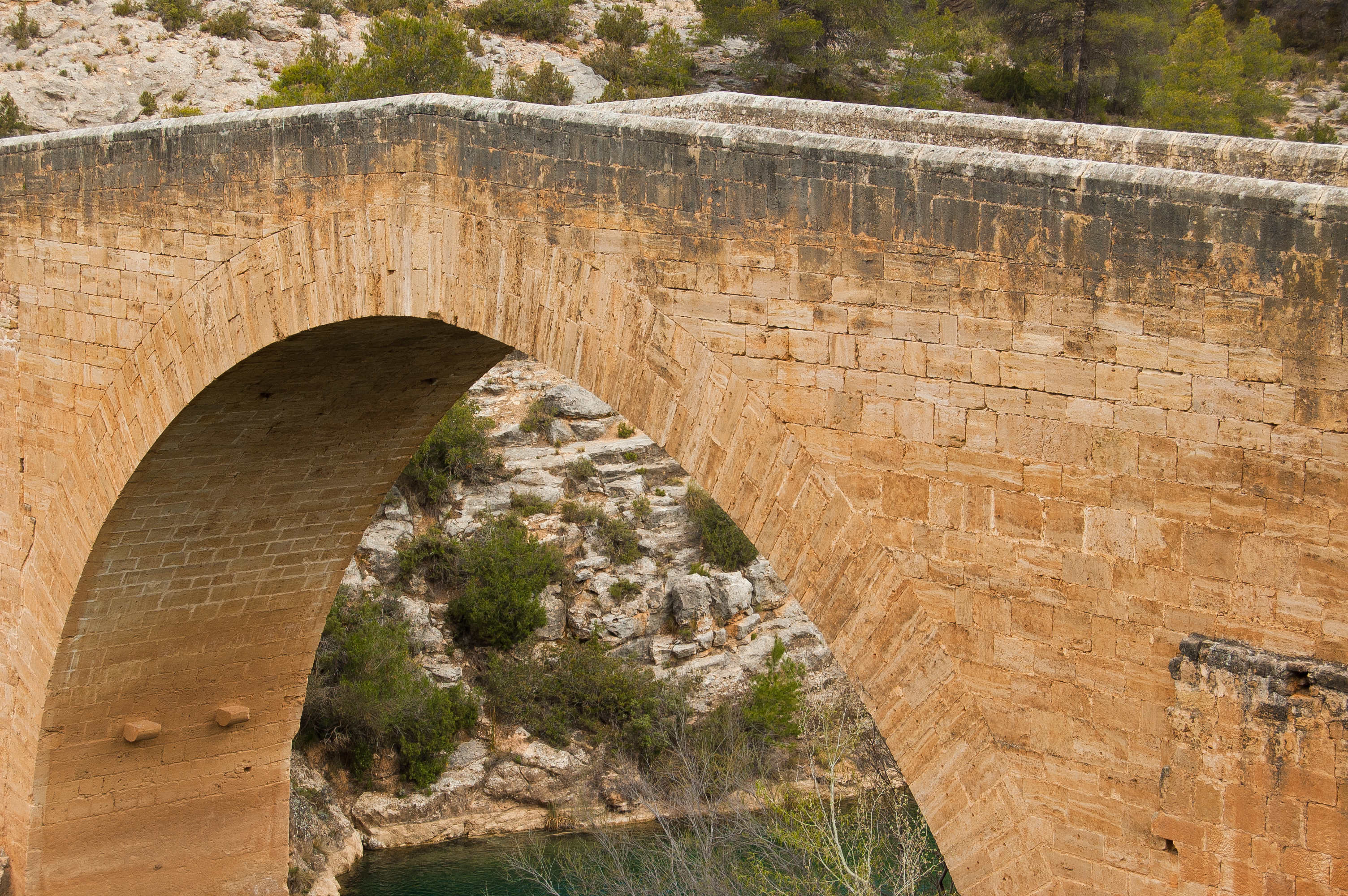
The town of Jaraguas marks the start of this last section, which also passes through Villargordo del Cabriel, a town steeped in history as witnessed by the trenches of the Carlist wars. The finishing touch is undoubtedly provided by the Hoces del Cabriel Natural Park, where the route ends next to the Vadocañas bridge, which crosses the waters of this riverbed.
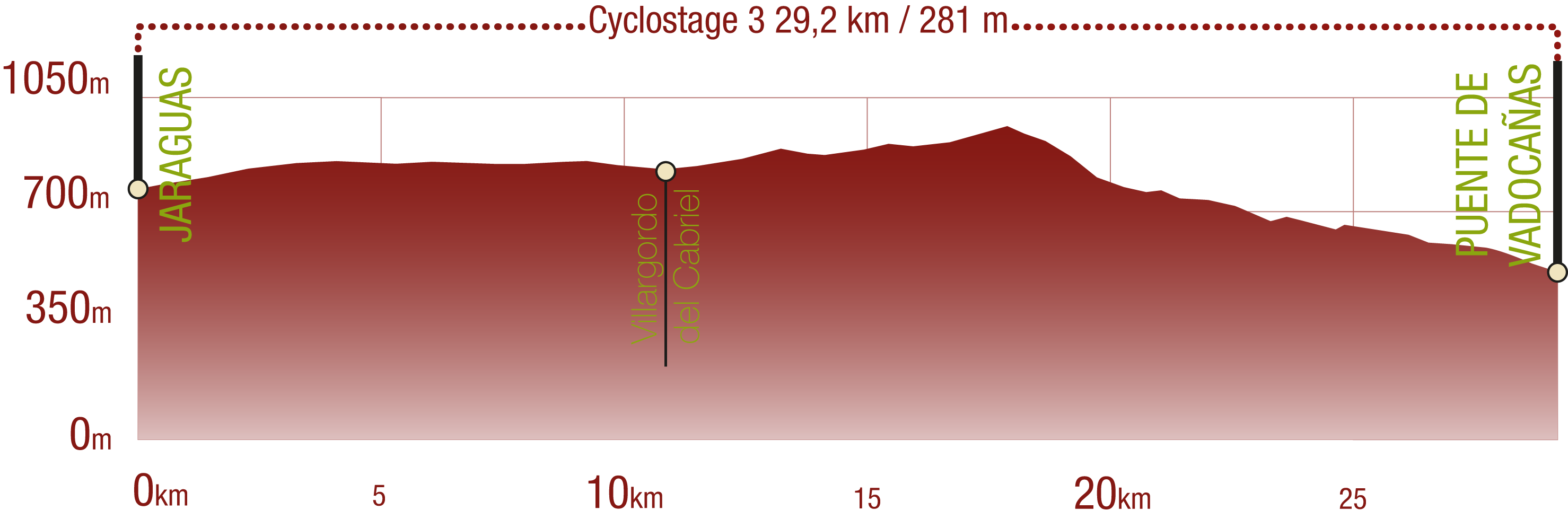
The third and last section of this Turia - Cabriel Nature Trail begins in the town of Jaraguas and enters the Hoces del Cabriel Natural Park after visiting the historic town of Villargordo del Cabriel.

The traveller leaves the town of Jaraguas along calle Almendros, crossing the CV-475 road, where precautions should be taken when crossing. The wide dirt path runs up among patches of Aleppo pines, vineyards and almond groves. A little further, the Nature Trail shares the tracing of the road for over two kilometres. After crossing the underpass under the Eastern Highway (A-3), the two tracings divide and our route takes a dirt path among vineyards and almond groves that stretches for over three kilometres, and crosses the N-III road more or less at the middle of this section.
Villargordo del Cabriel welcomes hikers as the route enters Calle Utiel, then Calle Carretera and finally Calle Moluengo before leaving the town behind. Some of the points of interest of this town are located outside the town centre. This is the case of the telegraph tower and the trenches that were dug in the Puerto de Contreras back in the Carlist wars.

Two underpasses follow, that allow to cross both the N-III road and the Eastern Highway (A-3). The tracing continues along a wide dirt path among vineyards and almond groves, which slowly give over their prominent role to pine woods as the Nature Trail gains altitude.
At kilometre point 108 there is a rest area where it is possible to find a panel with information on the natural beauty of the Hoces del Cabriel Natural Park, since the road now goes deep into this space. Shortly afterwards, a magnificent specimen of maritime pine (Pinus pinaster) locally known as Árbol Monumental (monumental tree) Pino de los Dos Hermanos. Standing tall with its 25 m of height, this tree clearly deserves a stop to be admired.

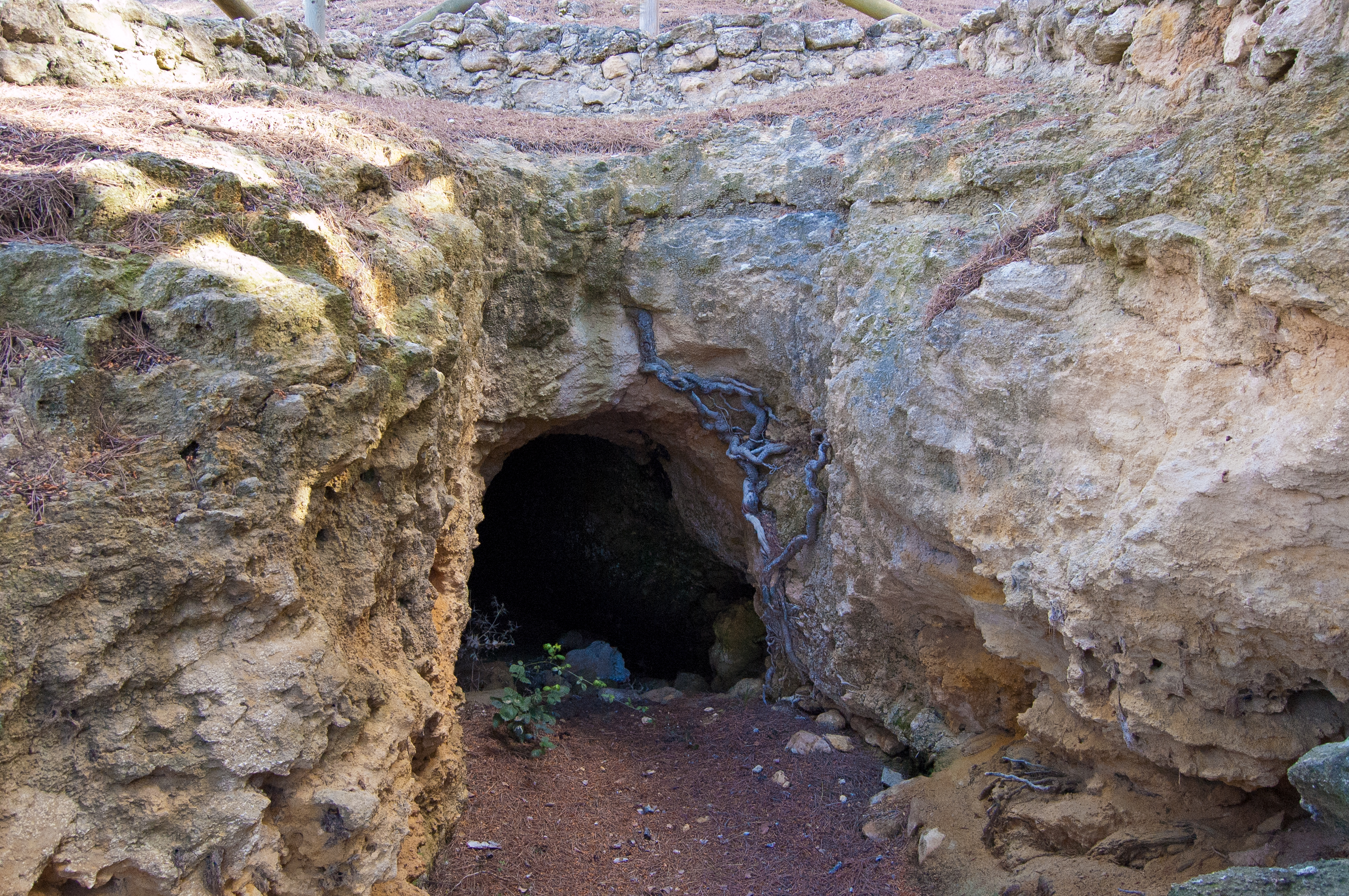
Once that the climb has been completed, the trail starts to go down, now completely surrounded by pine trees. After hitting kilometre point 111, the last section of the path begins. This time, it is short, a kilometre and a half, and known as Senda de la Cueva de los Ladrones. A remark for cyclists, though. Contrary to some previous sections, which may be suitable for cyclists provided that they are skilled enough, this section is not, because cycling along this path is prohibited according to the regulations of the Hoces del Cabriel Natural Park.
This traditional road zigzags down the pine woods and is signalled by the Nature Trail logo carved in stone. Thus, an effective signalling system is achieved with minimum impact on the environment. After hitting kilometre point 122 and arriving at the La Manchuela viewpoint, which offers spectacular views from a sort of natural window. This pretty path winds slowly down the slope until it reaches a wide path shortly after kilometre point 113.

Less than a kilometre afterwards stands the Fuente de la Oliva rest area, where a water spring and adjacent pond offer a perfect habitat for many species of amphibians. It is also frequented by many other wildlife species, which use its water to drink and be refreshed.
The last part of the route runs steeply down to the basin of the Cabriel River, in pine-covered area dotted by some small crop fields. Once kilometre point 121 is reached, and after a couple of curves, the finishing point is finally reached: the majestic Vadocañas Bridge over the waters of the River Cabriel, which makes a magnificent end to this Turia – Cabriel Nature Trail.
Sites of interest
Puntos de interés
Culture
- Trinchera Camino Real
- Trinchera Huerta la Carpia
- Casas de Moluengo
- Trinchera Camino Peñas Blancas
- Torre del telégrafo
Hydrography
Information
Infrastructure
Municipality
Orography
Vegetation
Profile

 Harshness of natural environment
- 1. The environment is not risk-free
- 2. There are more than one risk factors
- 3. There are various risk factors
- 4. There are quite a lot of risk factors
- 5. There are many risk factors
 Guidance along the route
- 1. Well defined trails and crossings
- 2. There is a clearly marked trail and signage
- 3. Requires the identification of geographic features and cardinal points
- 4. Requires off-path navigation
- 5. The trail is interrupted by obstacles that have to be gone around
 Route difficulty
- 1. Walking on a flat surface
- 2. Trails with different types of path
- 3. Walking on stepped paths or irregular terrain
- 4. The use of hands or jumping over the terrain is necessary
- 5. The use of hands is required to progress
 Amount of effort needed
- 1. Up to 1 hour of continuous walking
- 2. Between 1 and 3 hours of continuous walking
- 3. Between 3 and 6 hours of continuous walking
- 4. Between 6 and 10 hours of actual walking
- 5. More than 10 hours of continuous walking
(Calculated according to the MIDE criteria for an average excursionist with a light load)
Highlights
Further information
Hoces del Cabriel Natural Park
Natural Park stretching over 31446 hectares distributed between the municipalities of Requena, Villargordo del Cabriel and Venta del Moro, and protected by Decree 115/2005, of 17 June, of the Valencia Regional Goverment [Consell de la Generalitat] declaring the status as Natural Park of Hoces del Cabriel. The protagonist of this protected natural area is the River Cabriel and its top quality waters, whose erosive action over the centuries has modelled the dolomite and limestone and sculpted this landscape of canyons and gorges. Due to the steep relief, this landscape has been barely modified by human action, although, among its ethnographic architectural heritage linked to the river, such as the Noria de los Basilios scoop wheel or the Badocañas bridge. Among is vegetation, the well preserved riverside forests are especially noteworthy, and, a little away from the river shores, the Aleppo pine woods as well as small patch of evergreen oak and Pyrenean oak. Wildlife is also linked to the River Cabriel, and includes otters and European shore crab. There are also significant populations of Iberian ibex, boar and birds of prey such as the golden eagle. This environment allows for many activities, such as classic climbing in the gorges and hiking in any of its sis main hiking routes, perfectly signalled by colour (yellow, orange, red, blue, green and purple), which allow to explore the most beautiful spots of this Hoces del Cabriel Natural Park.
Multimedia


Downloads

GPS Downloads


Cyclability
PROFILE
TYPE OF ROAD, PORTAGES & DIFFICULTY
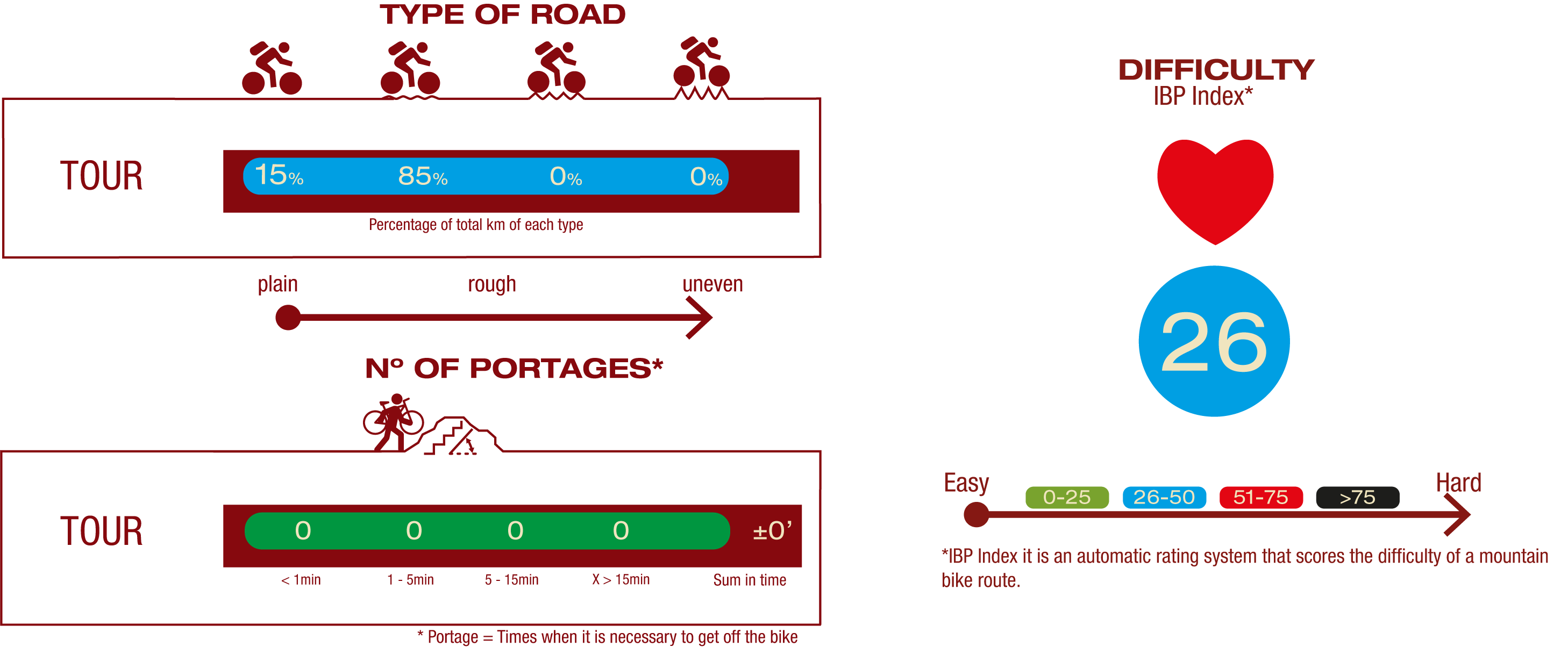
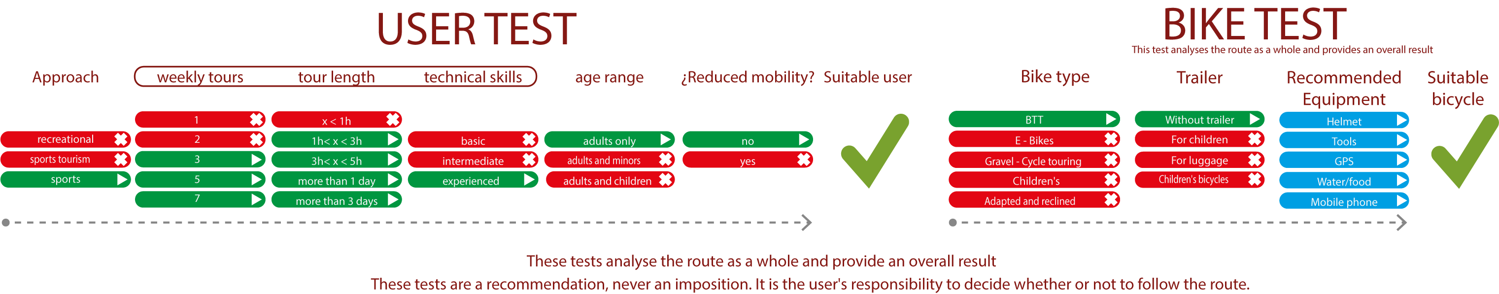
TEST
SAFETY RECOMMENDATIONS
- Sections shared with hikers.
- Transit through the centre of some population centres.
- The Nature Trail has two potentially flood-prone sections in stage 2. This is a seasonal circumstance, during the rainy season or when there is an increase in water flow.
GENERAL RECOMMENDATIONS
- Find out about the technical aspects of the route and the weather on the day.
- Take care of the environment. Take care not to disturb animals or damage vegetation. Respect private areas.
- You must give priority to pedestrians and comply with general traffic rules.
- The environment in which you will be riding is open, free to move around and an area where many activities are carried out (sporting, forestry, livestock and agricultural activities). Always have an understanding, prudent, responsible and respectful attitude.