


Net of Nature
Trails

Stage 1: San Sebastián de La Gomera - Degollada de Peraza






Description
Connecting the sites of greatest historical significance in the history of La Gomera, the island's capital and the site where the 1488 Gomero Rebellion began
This stage runs from San Sebastián de La Gomera to the Degollada de Peraza viewpoint along a 9.8-kilometre uphill route, where visitors can admire the traditional architecture and spectacular views offered by the Barranco del Cabrito and Barranco de La Laja ravines, whose terraced slopes bear witness to the area’s rich agricultural heritage, while also enjoying the imposing outcrops of Roque Magro and Roque del Sombrero, as well as the characteristic vegetation of La Gomera.

An information panel located at the entrance to the harbour of the island’s capital marks the start of the stage. After walking a few metres along the seafront promenade, and following the signposts along the route, the trail circles Torre del Conde Park via Avenida del Quinto Centenario and continues, across the Barranco La Villa ravine, along the Cañada del Herrero and Avenida Las Galanas until as far as Cañada del Herrero, where the asphalted section ends and a new information panel appears. Remember these first 1.5 kilometres are entirely within the town centre, so you be mindful of traffic at all times.

From this point onwards, a challenging climb begins, covering just over a kilometre along a cobbled path that winds its way up the slope of El Lomo de las Vueltas, between the Barranco de Tajinastas ravine to the south and the Barranco de El Machal ravine to the north, to the area known as La Sabina or El Higueral. The panoramic views of San Sebastián Bay, with Mount Teide on the neighbouring island of Tenerife in the background are a highlight of this section of the trail. The path, which now continues to climb at a somewhat gentler gradient, winds through a landscape characterised by typical Canarian scrub vegetation, with tabaiba (Euphorbia berthelotii) and balo (Plocama pendula) predominating.
On several occasions, the route continues along short stretches of asphalted path alternating with sections of cobbled path that have served us well on the ascent. There is no danger here thanks to the absence of motor traffic. Nevertheless, the usual precautions must be taken.

After this first gruelling stretch of the climb, once the 5-kilometre mark has been passed, we leave the small village of Ayamosna behind. The area around the village was once known as one of the island’s most important granaries, as explained on the information panel. The cobbled path crosses the access road to the small village and continues for a few metres along an asphalted path.
The route then turns left onto a cobbled path, from which visitors can fully appreciate the splendid views offered by the Sombrero and Magro rock formations, both part of the Barranco del Cabrito Natural Monument, with countless terraces climbing up the slopes.
These are fine examples of popular engineering, consisting of small vertical stone walls, with which locals managed to reclaim a stretch of arable land in an island environment inhospitable to farming. Most of these terraces, where wheat, barley and peas (to use the common name for various species of legumes and their seeds) were traditionally grown, are now covered with tabaiba and century plants (Agave americana) and are freely grazed by sheep

From this vantage point, the visitor can observe the characteristic distribution of vegetation in these ravines, with numerous rock-dwelling plants and a few isolated patches of cardon, a cactus-like shrub, on the cliffs. In the foothills and on the ravine floors, the vegetation consists of scrubland with an abundance of balo, gorse (Launaea arborescens) and tabaiba, while on the slopes there are some concentrations of cardon (Euphorbia canariensis) and Canary Island date palm trees (Phoenix canariensis).
Passing the 7-kilometre mark, with Roque Magro and Roque del Sombrero still accompanying us, we reach the Mirador de La Tortuga viewpoint, where a small information board helps visitors interpret the landscape.
The path continues to climb, and soon beautiful, scattered specimens of Canary Island palm trees begin to appear, occupying small valleys. Reaching the pass at the foot of Cerro de Tagamiche hill, the path turns right, skirting the Vegueta mountain, towards the Degollada de Peraza viewpoint. Here, the trail been converted into a well-defined footpath, protected by a railing in the most exposed sections of the route. It takes us along the edge of the Barranco de Las Lajas ravine, offering spectacular views of the ravine itself, the rural hamlet of La Laja and Chejelipes. In the ravine bed we can also make out the Palacios and Chejelipes dams.

Towards the end of this stage, the first heather plants (Erica arborea) begin to emerge among the tabaiba, jaguarzo (Cistus monspeliensis), century plants and palm trees, accompanying us along a winding path that zig-zags its way up to the Degollada de Peraza viewpoint, where this first stage of the Nature Trail comes to an end. For those tackling the next stage of the route, it is advisable to cross the GM-2 road and take in the panoramic view of the Barranco de Juan de Vera ravine.
This short yet gruelling first stage ends at one of the most historic spots on the whole island of La Gomera. As the name suggests, at Degollada de Peraza, the legendary Gomero warrior , Hautacuperche , killed Hernán Peraza “the Younger” for breaking the pact of kinship that had bound them for several generations. This incident would spark what is commonly known as the Gomero rebellion, which ended tragically for the pre-Hispanic indigenous Gomeros with the subsequent military expedition led by Pedro de Vera, governor of Gran Canaria.
Entidades gestoras
Puntos de interés
Information
Municipality
Orography
Hostel
Vegetation
Passport
Profile
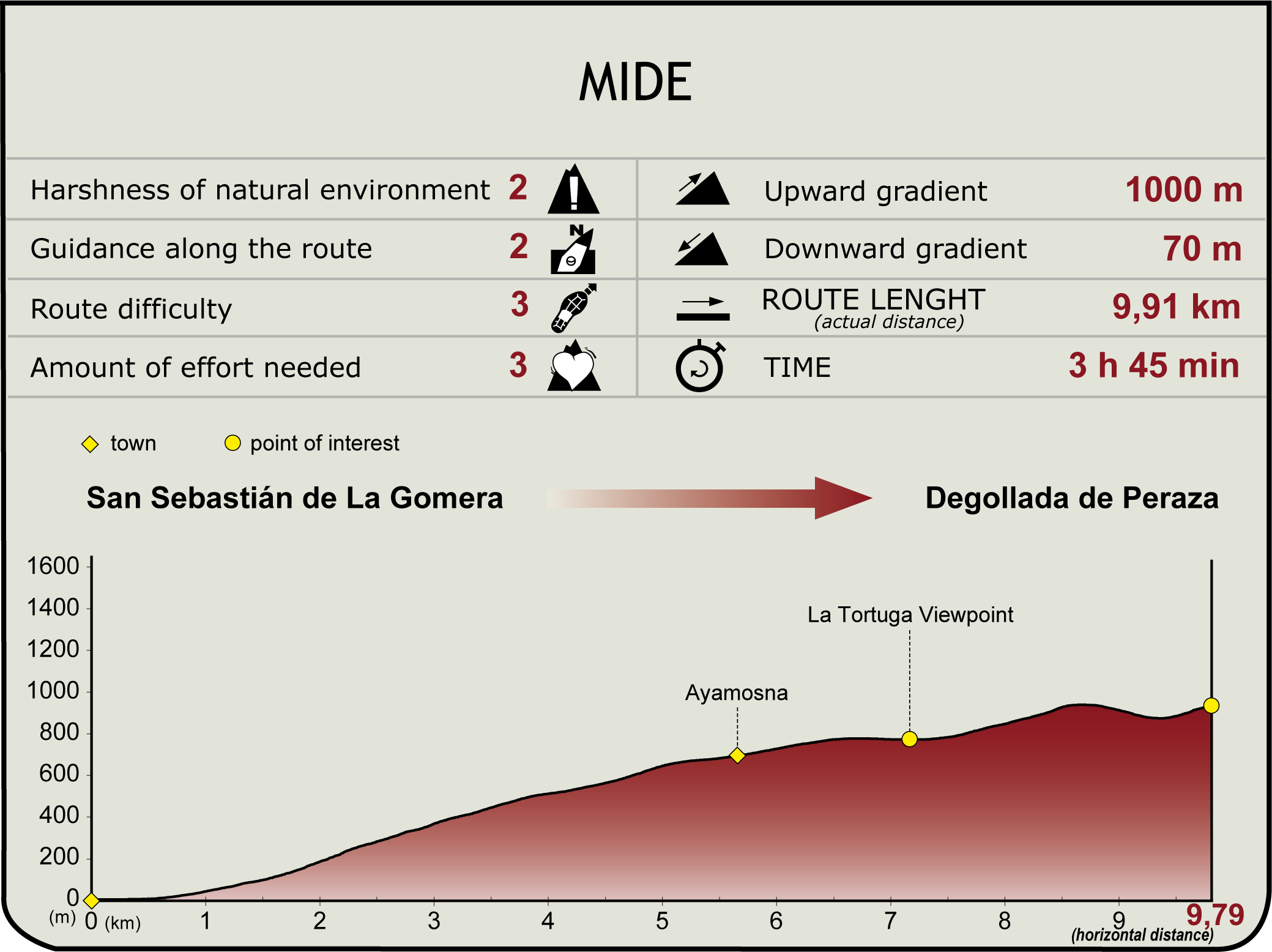
 Harshness of natural environment
- 1. The environment is not risk-free
- 2. There are more than one risk factors
- 3. There are various risk factors
- 4. There are quite a lot of risk factors
- 5. There are many risk factors
 Guidance along the route
- 1. Well defined trails and crossings
- 2. There is a clearly marked trail and signage
- 3. Requires the identification of geographic features and cardinal points
- 4. Requires off-path navigation
- 5. The trail is interrupted by obstacles that have to be gone around
 Route difficulty
- 1. Walking on a flat surface
- 2. Trails with different types of path
- 3. Walking on stepped paths or irregular terrain
- 4. The use of hands or jumping over the terrain is necessary
- 5. The use of hands is required to progress
 Amount of effort needed
- 1. Up to 1 hour of continuous walking
- 2. Between 1 and 3 hours of continuous walking
- 3. Between 3 and 6 hours of continuous walking
- 4. Between 6 and 10 hours of actual walking
- 5. More than 10 hours of continuous walking
(Calculated according to the MIDE criteria for an average excursionist with a light load)
Highlights
Further information
San Sebastián de La Gomera
San Sebastián de La Gomera, popularly known as La Villa, is the capital city of the island and therefore its entrance gate. This port was the last stop of Columbus before departing towards the discovery of America in 1492. Nowadays, the Columbus House, where he stayed, is a museum open to the public.
The traditional Columbian architecture is present in La Villa, combined with modern buildings such as the National Tourism Parador “Conde de La Gomera”, the Cabildo Insular (island council) or the Insular Auditorium “Infanta Cristina”. The church of Nuestra Señora de la Asunción is the main temple of the capital city, and today it is a museum and a reminder of adventures and misadventures of the past, as it suffered from multiple fires and pirate attacks throughout its history.
The hermitage of the Virgin of Guadalupe, patron saint of the island, is located in this town, though not within the urban area, but in the Natural Special Reserve of Puntallana.
Multimedia


Downloads

GPS Downloads