

Net of Nature
Trails

Stage 8: Playa de Santiago - San Sebastián de La Gomera
Description
This trail goes from Playa de Santiago to la Villa through deserted areas, hills, gullies and beaches, which have witnessed the man’s passage and the force of nature.
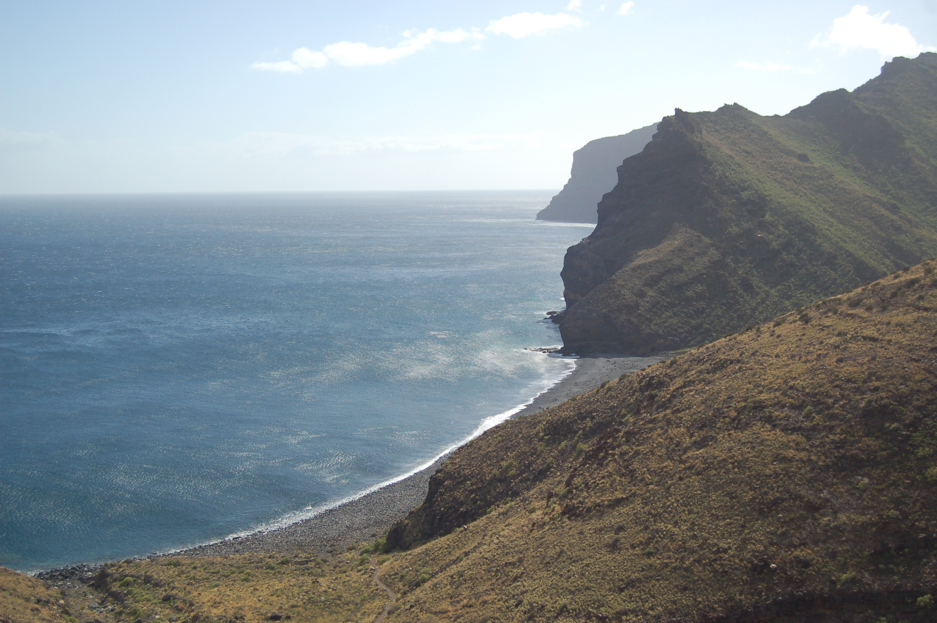
This last stage of the Shores of La Gomera Nature Trail begins in the town of Playa de Santiago, which belongs to the municipality of Alajeró. It goes through numerous gullies and beaches of high landscape value, such as the beach of the Cabrito (Natural Monument) and the beach of the Guancha. The traveller will be able to see how the agricultural tasks Canary Island spurges proliferated there. San Sebastián de La Gomera, capital of the island which is also known as “la Villa”, is the endpoint of this last stage of the Shores of La Gomera Nature Trail.

This stage begins where the Playa de Santiago promenade ends, a town centre with a large beach and an important maritime port. The traveller walks through the right pavement of the avenida Marítima, crossing the Santiago gully and leaving family vegetable gardens and banana trees behind.
When the trail arrives at the town of Tecina, the traveller leaves the pavement and begins to climb some stairs, first among houses and then in open lands, while admiring the spectacular view of Playa de Santiago. After this stairs stretch ends, the trail continues going up through the right pavement that runs in parallel with the GM-3 road. Later, it passes a 'guaguas`' stop and, shortly after, it turns right through calle Hotel, so that the traveller can cross the pedestrian crossing. It keeps going through the left pavement during a flat stretch, which is surrounded at both sides by the hotel complexes of Tecina.

After the trail passes kilometre 109 of the Shores of La Gomera Nature Trail and coinciding with a light curve on the right, the traveller begins to go down to the gully of Tapahuga, where it goes through the right pavement.
Once the trail goes past kilometre 110, the traveller must cross the paved street known as Playa de Santiago, where the trail takes a dirt path that goes through the riverbed of the gully of Tapahuga. Later, the trail begins an uphill stretch that goes past the hill of Tecina and then it continues down to the houses of the Joradillo through a paved track. This track leads to a narrow path which winds up to the aforementioned houses. When the trail arrives at the houses, it turns left and, a few metres later through a paved road, the trail becomes a narrow path again. It continues running among terraces which were cultivated in the past and where today grows the Canary Island spurges.

While going down, the traveller passes kilometre 112, from where it continues through a wide path in the bottom of the gully of Chinguarime. Shortly after, the trail turns right in order to run among banana crops. Once the trail has passed this crop fields, the traveller takes a narrow path that crosses the gully’s ravine to begin a hard uphill slope.
After reaching kilometre 113, going through different uphill stretches, the trail leaves several cattle constructions behind. These constructions are part of the houses of Contreras, which now are in ruins. Shortly after, the trail arrives at an old stately house, where two other island trails meet.
Once the Guincho gully has been passed in kilometre 116, the stretch leading to the old Seima settlement (also known as the houses of Morales) begins. This settlement is now in ruins and it has an old stone oven the traveller can admire.

The trail’s route gives the traveller a break and begins a downhill stretch that enters the Natural Monument of the Cabrito. After passing kilometre 120, this downhill descent becomes steeper and the trail winds down the slope until the trail reaches the Hotel Finca El Cabrito, which is located next to the namesake beach. When the beach stretch ends, the trail turns left through a wide path that takes the traveller away from the coast. A few metres later, the trail crosses the Juan Vera gully and begins to go up again, entering the Natural Monument of the Cabrito perimeter.
Shortly after the trail passes kilometre 122, it begins to go down the Guancha gully to the namesake beach, where the traveller will be able to admire the dazzling beauty of the environment. Once the beach of La Guancha buildings and kilometre 124 have been passed, the trail goes up. A few metres after, the traveller leaves the Natural Monument of the Cabrito behind and the trail runs these last kilometres close to the coastline, where the beautiful panoramic view of the Atlantic ocean and Tenerife island can be admired. In clear days, the traveller will also be able to see the distinctive profile of the Teide.

Shortly after reaching the Higueral hill highest point, the traveller will be able to see San Sebastián de La Gomera for the first time. After the descent, the traveller enters the capital of the island through the industrial estate. The trail goes specifically through the paved road known as gully of La Concepción, which runs through the right pavement next to the GM-2 road, until the trail crosses La Villa gully and arrives at to the roundabout where the GM-1 and GM-2 roads meet, already in the town centre of la Villa. Up to this point, after more than 20 km, the eight stage of the Shores of La Gomera Nature Trail ends.
Managing Entities
Sites of interest
Puntos de interés
Culture
Municipality
Orography
Hostel
Passport
Profile

 Harshness of natural environment
- 1. The environment is not risk-free
- 2. There are more than one risk factors
- 3. There are various risk factors
- 4. There are quite a lot of risk factors
- 5. There are many risk factors
 Guidance along the route
- 1. Well defined trails and crossings
- 2. There is a clearly marked trail and signage
- 3. Requires the identification of geographic features and cardinal points
- 4. Requires off-path navigation
- 5. The trail is interrupted by obstacles that have to be gone around
 Route difficulty
- 1. Walking on a flat surface
- 2. Trails with different types of path
- 3. Walking on stepped paths or irregular terrain
- 4. The use of hands or jumping over the terrain is necessary
- 5. The use of hands is required to progress
 Amount of effort needed
- 1. Up to 1 hour of continuous walking
- 2. Between 1 and 3 hours of continuous walking
- 3. Between 3 and 6 hours of continuous walking
- 4. Between 6 and 10 hours of actual walking
- 5. More than 10 hours of continuous walking
(Calculated according to the MIDE criteria for an average excursionist with a light load)
Highlights
Further information
Natural Monument of the Cabrito
The Natural Monument of the Cabrito is located in the low and medium areas of the namesake gully, in the region of San Sebastián de La Gomera. The main flora in this gully is made up by coastal and xerophile species (adapted to dry environments). There are also plenty of euphorbias and some palm tree forests.
The Cabrito basin is formed by gullies that offer a peculiar landscape, in which crests and roques of watersheds are relevant elements in its geomorphology and the palm tree forest stands out in its slopes. The erosion has been the essential element in this formations’ configuration.
In the Vegaipala and Jerduñe areas, the traditional landscape is not against small villages, which in any case add interesting cultural elements to it.
The Cabrito beach is located in the coast, in an almost virgin and isolated setting, although out of the borders of the Natural Monument. The traveller can access to it on foot through a path that goes from San Sebastian to the Cabrito, but it is usually visited by boat. This beach is 450 m long and 40 m wide on average and it has black sand, pebbles and calm waters.
Canary Island spurges
It is the characteristic flora of the coastal areas in the Canary Islands and it appears in low altitude areas with high temperatures and low humidity. It forms natural masses and takes up abandoned crop fields extensions, being common in the terraced slopes of La Gomera where the agriculture activity has disappeared.
The main species are the Canary Island spurge (Euphorbia canariensis) and the tabaibas, also Euphorbia (Euphorbia regis-jubae, Euphorbia balsamífera, Euphorbia atropurpurea )Multimedia


Downloads

GPS Downloads


