Net of Natural
Trails
Segura Nature Trail. Arroyo del Ojanco - province border section
Description
A landscape of olive trees under the shelter of the Segura Mountain Range.
The Segura Nature Trail uses the Jaén stretch of the ambitious railway project designed to link the towns of Utiel, in Valencia, and Úbeda, in Jaén. The trail goes through the municipalities of Arroyo del Ojanco, Segura de la Sierra, Puente de Génave, La Puerta de Segura, Génave and Villarrodrigo, as well as the Sierras de Cazorla, Segura y Las Villas Natural Park, the largest protected area in Spain.
Travellers can access the beginning of the trail from the N-322 road, almost at kilometre number 217, a few kilometres before Arroyo de Ojanco and one kilometre before the station which used to give service to this town, now in ruins. It is important to know that, although it is not difficult to access the different towns near the trail, there is no way to find water along the route, so it is advisable to take enough water with you.
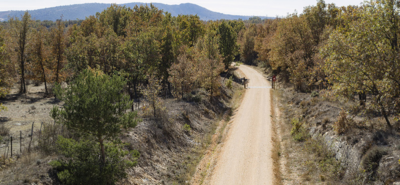
Near a country house in an olive tree forest, there is an information display panel telling the traveller where this 27-kilometre trail begins. This trail uses the old railway platform, which can be seen in the different infrastructures, passes, tunnels and bridges that were built for the railway and were never used.
The first of the infrastructures the travellers will see, after a slight downhill slope, is a viaduct over the Guadalaviar river, where an uphill slope starts that will remain constant until the end of the trail. Shortly afterwards, the first of many passes under paths or roads appears right before a stretch shared with vehicles, giving access to a water irrigation pond. Then, the traveller reaches a rest area located on the top of another pass over the railway platform .
For the first ten kilometres (and for the greatest part of the Segura Nature Trail), the olive tree forest is the prevailing landscape, changing only when the trail goes over a stream or through the brooms covering the slopes on both sides of the trail. The trail is not difficult during this first stretch, since it goes almost straight, crossing streams or tunnels and leaving a rest area in the shade of a big pine tree aside, until another shared stretch is reached. Right after passing a small bridge over a road, the traveller must be especially cautious, since the trail leaves the dirt path and takes a road on the right in order to cross the N-322 road. Once on the other side, the trail takes a branch on the left leading back to the dirt path, and it then reaches the Puente de Génave station (in ruins). Travellers can also easily access the trail through this point, taking advantage of its parking lot.
Once the rest area of the Puente de Génave station is left behind, the trail bends to the left, approaching the town of Bonache, while it enters the Sierras de Cazorla, Segura y las Villas Natural Park. The landscape changes when the trail enters a small pine mass for a few kilometres. This bend changes direction abruptly when the trail goes near a dam in the Viña stream and it then leaves the pine forest, shortly after another rest area.
The trail continues among olive trees for one and a half kilometres, before going left again. The surrounding vegetation changes to Mediterranean scrubs and brooms. Later, a big pine tree marks the proximity of the longest tunnel along the trail. Although it is perfectly preserved, the traveller must be cautious because there is no light and the only light reference is the exit of this tunnel, almost 300 m long.On the other side of the tunnel, the trail goes up to the Génave train station. Travellers can enter the town of Génave from this point, where the tower of La Tercia (which has been declared a Site of Cultural Interest) and the church of La Inmaculada Concepción stand out.
Later on, when going over a couple of streams in a long straight stretch, travellers will be able to admire the views and the tower of La Laguna, atop a hill on the left side of the trail. It belongs to the municipality of Génave and it has also been declared a Site of Cultural Interest.
The landscape changes again when the trail goes under a path, leaving the ruins of a country house aside and entering a holm oak forest for a hundred metres.
This is the end of the olive tree forest as a constant landscape, although it will continue dominating the ranges on the background. Near the trail, there are brooms and some holm oaks for the first stretch and crop fields when the trail approaches Villarrodrigo station. This station, as the one in Génave, is used as a farm machinery warehouse.
Next to a rest area, the branch leading to the town of Villarrodrigo (which is not really on the way) is the last place from where this nature trail can be easily accessed, through a secondary road linking the N-322 road to the aforementioned town.
The Segura Nature Trail continues among crop fields for one kilometre and a half until the province border is reached, where it meets the Sierra de Alcaraz Nature Trail.
Sites of interest
Puntos de interés
Hydrography
Infrastructure
- Túnel
- Túnel
- Antigua estación de Villarodrigo
- Antigua estación de Génave
- Puente sobre el río Guadalimar
- Antigua estación de Puente de Génave
Municipality
Orography
Hostel
Vegetation
Profile
Highlights
Further information
Sierras de Cazorla, Segura y Las Villas Natural Park
The Segura Nature Trail runs entirely through the region of Sierra de Segura, which makes up the 70% of the surface of the Sierras de Cazorla, Segura y Las Villas Natural Park.
This Natural Park is the largest protected area in Spain. The UNESCO declared this group of mountains as a Biosphere Reserve in 1983 and the European Union also considers these ranges as a privileged natural area, so they declared it an SPA (Special Protection Area) in 1988 and an SCI (Site of Community Importance) in 2006, it becoming a part of the Natura 2000 network. Since 2017, it is also a Special Area of Conservation
Baeza-Utiel railway line
The Baeza-Utiel railway line, sometimes known as the Baeza-Albacete line, was an ambitious railway project which was never completed and that would link the Spanish towns of Baeza and Utiel. It was part of a largest project that was supposed to go up to the French border. Although its construction started in the 1920s, the project was delayed in many occasions over more than thirty years and, in 1964, the works were stopped and the project discarded. The unfinished line was definitely dismantled at the beginning of the 1990s. Today, its route is being recovered for the Nature Trails program.
The Baeza-Utiel line had a total 366 kilometres of railway tracks from Valencia to Utiel. It also had 107 tunnels and 25 viaducst. Although 28 stations had been planned, the number was finally reduced and only 12 stations were built. In 1964, when the works stopped, the railway tracks between Albacete and the province of Jaén border were already built, which meant a total of 108 kilometres of railway tracks.
After reaching Utiel, they had planned this line to continue to the north, going across the peninsula. Its main stations will be located in Teruel, Alcañiz, Lérida, Puebla de Seguro and Saint Girons (France). In fact, the stretch between Lérida and Puebla de Segur was the only one of this project that worked.
Livestock breeds
In recent years there has been a great promotion to recover the livestock activities that, due to the historical significance of the forestry and pastoral activities maintained in the Natural Park of Sierras de Cazorla, Segura y las Villas, had been put on the backburner. However, this effort has led to the strong emergence of the farming of a livestock population mainly comprised by specimens of the Segureña sheep breed and the Negra Serrana and Blanca Andaluza goat breeds. Its great hardiness and its high ability to graze are the perfect characteristics to use the mountain forage resources, by means of its intensive farming and the practice of seasonal movements of shepherds and livestock over the high peaks of the mountain ranges during the summer, and the low areas of the valleys during the winter.
Additionally, these breeds play an important environmental role, as thanks to the grazing they contribute to the prevention of fires by means of the cleaning of our mountains and the fertilisation of the field, thus increasing the fertility of soils and the dispersal of seeds.
Multimedia
Downloads
GPS Downloads
Cyclability
PROFILE & DIFFICULTY
SAFETY RECOMMENDATIONS
-Caution on dirt roads juntions, in small section shared with motor vehicles and in small tunnels with and without artificial lighting.
GENERAL RECOMMENDATIONS
-Find out about the technical aspects of the route and the weather on the day.
-Take care of the environment. Take care not to disturb animals or damage vegetation. Respect private areas.
-You must give priority to pedestrians and comply with general traffic rules.
-The environment in which you will be riding is open, free to move around and an area where many activities are carried out (sporting, forestry, livestock and agricultural activities). Always have an understanding, prudent, responsible and respectful attitude.