

Net of Nature
Trails

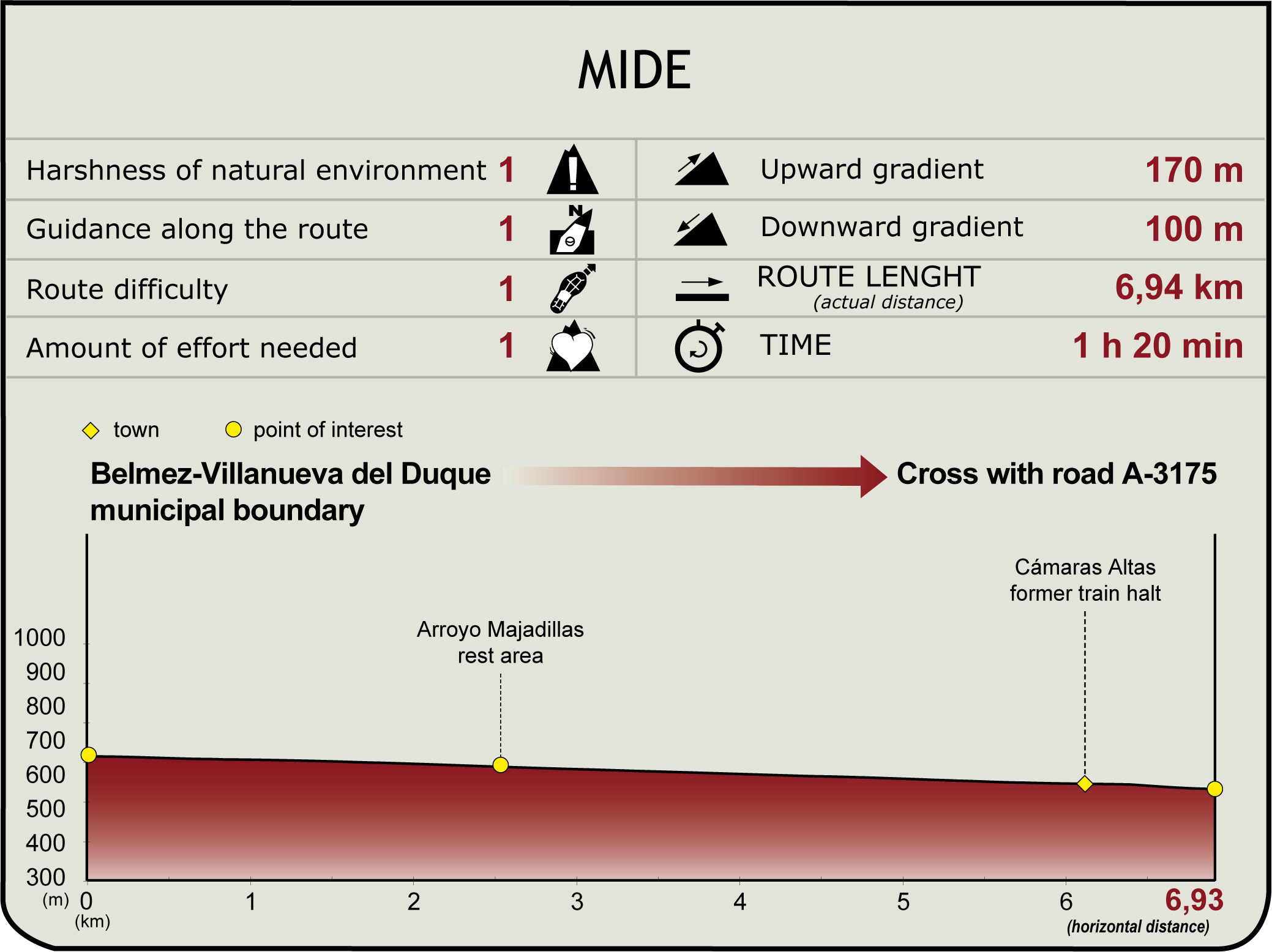
Guadiato Greenway Nature Trail
Description
From Los Pedroches to the Guadiato Valley along the old mining railway line
Starting at the municipal boundary of Belmez and Villanueva del Duque, which also marks the border between the comarcas of Los Pedroches and Valle del Guadiato, this comfortable route along the course of the old Peñarroya-Puertollano mining railway runs through undulating terrain between pine forests, holm oak pastures and olive groves.

The Nature Trail starts near the boundary between the municipalities of Belmez and Villanueva del Duque, next to an information panel. Another route that also makes use of the same dismantled railway platform ends at the same point: the La Minería Greenway, which connects this point with the facilities of the what used to be the El Soldado mine.
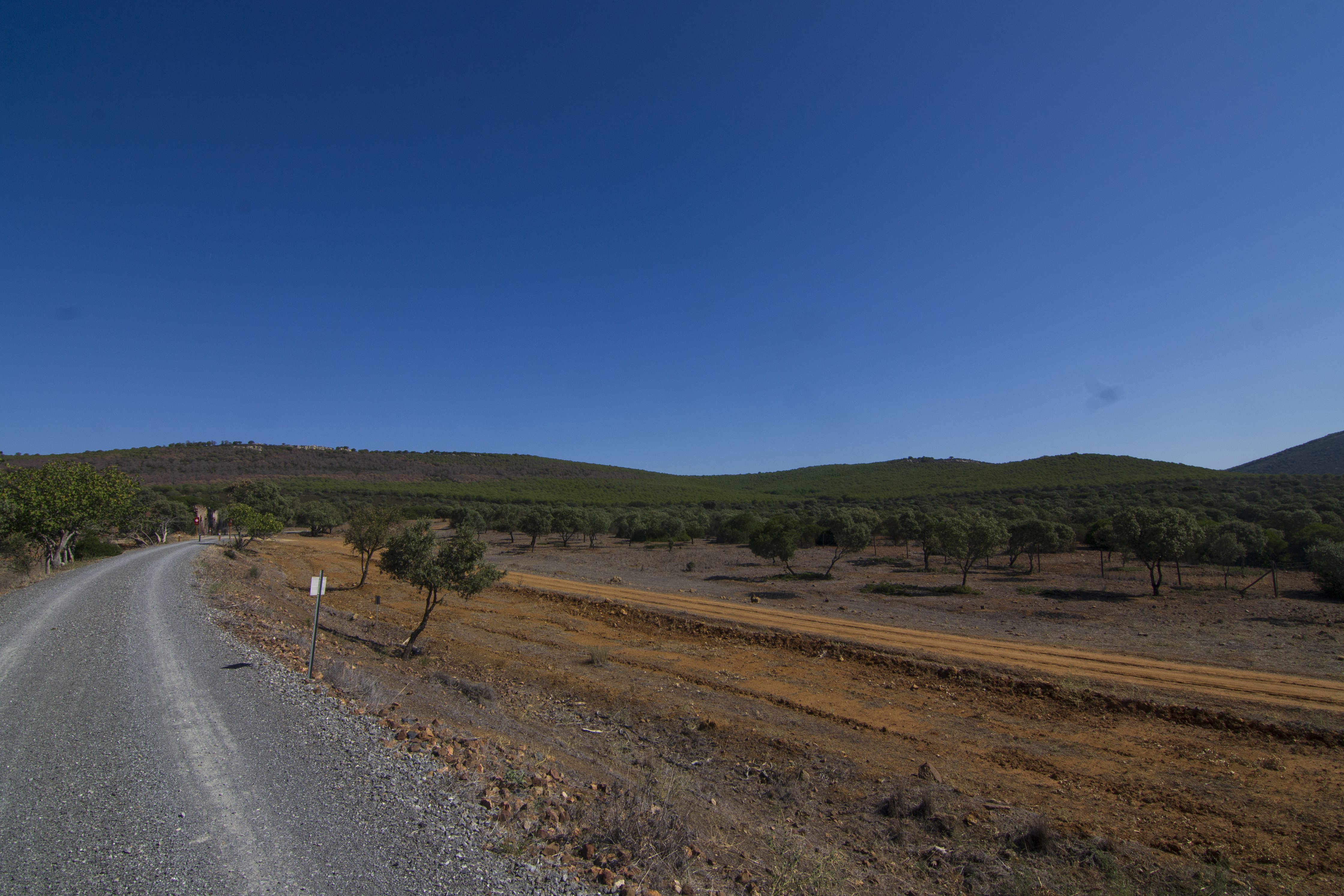
The first few kilometres of the route are in the company of the stone pines (Pinus pinea) and cluster pines (P. pinaster) of a reforested mixed pine forest, with the occasional appearance of the holm oak (Quercus ilex) and Mediterranean scrubland on the steeper slopes.

Just 300 metres from the start of the route, a building appears on the left hand side, one of the many auxiliary infrastructures, in varying states of ruin, dating back to when the railway was in operation. These were generally used as warehouses or accommodation for the labourers responsible for the maintenance of the track.
After approximately 1.5 km, the route begins to skirt the valley of one of the tributaries of the Majadilla stream. So much so that, from this point, you can perfectly make out the route of the Nature Trail on the other side of the valley. At this point, there is a momentary change of scenery as we pass over the stream, where tall eucalyptus trees replace the pines for a fleeting 100 metres.

After half a kilometre there is a rest area that has been set up on an esplanade to the right of the path, where you can take a break to regain energy and take in the beautiful scenery. On resuming the path and following it for another half kilometre, we reach another landmark of the route: a trench closely linked to the railway past of the area. The trench cuts through the terrain and along with another one 600 metres further on, will delight geology enthusiasts, revealing the layers of limestone that make up the mountains.

The trail continues to take us back to a time when trains were still running on the line, as we pass another building alongside the railway, a prelude to a pine forest and a meadow of holm oaks with a low density of trees. Along this part of the route, the pine groves become fewer and far between, as the Mediterranean scrubland becomes more common along with rockrose (Cistus spp.), gorse (Genista scorpius), broom and labiatae.
After another bend, not as sharp as the one described above, the meadow is joined by some tree plantations with olive and fruit trees and, in the floral procession, on the sides of the path there are mastic trees (Pistacea lentiscus) and other trees probably from a nearby orchard, such as fig trees (Ficus carica) or pear trees (Pyrus sp.).

We reach the old Cámaras Altas station, with the appearance, once again, of some eucalyptus trees. Of this old piece of infrastructure, the warehouse, the main station building and some auxiliary buildings such as a hut and a water tank have been preserved. Most of the facilities lies in ruins except for the warehouse, which is in private hands. At this point, between the station and the warehouse, a rest area has been set up where you can take a rest if you haven’t had taken a moment's respite along the way.

From this point on, the road user must pay attention, as the remainder of the route runs along a path that is shared with motorised vehicles. After passing the crossroads that gives access to Cámaras Altas from the road, we continue for another 400 metres until we reach a wooden footbridge over the Majadilla stream. Crossing the stream, we pass in front of the access gate to a large pasture and keep on straight for 300 metres to the end of this route, at the junction with the CO-440 road. The town of Belmez, offering all kinds of services, is about 7 kilometres along this road.
The Guadiato Greenway Nature Trial, together with the neighbouring La Minería, La Maquinilla, Peñarroya-Pueblonuevo and Fuente Obejuna Greenways, forms part of a series of routes along the old mining railway lines, which together have been called the Guadiato and Los Pedroches Greenway, as they run through these two comarcas of Cordoba.
Puntos de interés
Culture
Hydrography
Infrastructure
- Minería Greenway
- Cámaras Altas Siding
- La Maquinilla Greenway
- Guadiato Greenway
- Belmez former station
Municipality
Orography
Profile
 Harshness of natural environment
- 1. The environment is not risk-free
- 2. There are more than one risk factors
- 3. There are various risk factors
- 4. There are quite a lot of risk factors
- 5. There are many risk factors
 Guidance along the route
- 1. Well defined trails and crossings
- 2. There is a clearly marked trail and signage
- 3. Requires the identification of geographic features and cardinal points
- 4. Requires off-path navigation
- 5. The trail is interrupted by obstacles that have to be gone around
 Route difficulty
- 1. Walking on a flat surface
- 2. Trails with different types of path
- 3. Walking on stepped paths or irregular terrain
- 4. The use of hands or jumping over the terrain is necessary
- 5. The use of hands is required to progress
 Amount of effort needed
- 1. Up to 1 hour of continuous walking
- 2. Between 1 and 3 hours of continuous walking
- 3. Between 3 and 6 hours of continuous walking
- 4. Between 6 and 10 hours of actual walking
- 5. More than 10 hours of continuous walking
(Calculated according to the MIDE criteria for an average excursionist with a light load)
Highlights
Further information
Belmez
This village and municipality in the comarca of Guadiato Valley, must have been populated at least since the Middle Neolithic period, as evidenced by the various megalithic monuments found today, although other remains may date back to the Palaeolithic period.
Due to the mining and metallurgical wealth of the area, it was a territory occupied by the Tartessians and Phoenicians, but it is from the Roman period that most remains have been preserved, in the form of copper or iron mines and funerary tombstones. There is also a Visigothic presence, a settlement having been found south of the village of El Hoyo.
The first written references to Belmez date back to 1254. They concern the siege of Jaén during the Christian conquest, when Ferdinand III ceded the town of Priego de Córdoba to the Order of Calatrava in exchange for the castle of Belmez and its territory. Later, Alfonso XI granted the town the title of Muy Leal Villa and, centuries later, Felipe II added the title of Muy Noble Villa, or “very loyal village”.
The economy of the town was based on livestock and agriculture until, in the late 17th century, coal was discovered in the subsoil, and mining took over. The Cabeza de Vaca Mine is the first one on record.
In the 19th century, the mines were operated by the Sociedad Hullera y Metalúrgica de Belmez until the founding, at the end of the century, of the Sociedad Minero Metalúrgica Peñarroya, which monopolised coal mining until the middle of the 20th century when it ceased activity in the province of Córdoba. At that time, the Empresa Nacional Carbonífera del Sur, today ENDESA, was created and was responsible for the exploitation of the mineral in the area until well into the 21st century.
In terms of local heritage, what is most striking at first sight is the castle which, perched on a high limestone promontory, stands watch over the town. It may have been built on top of another fortress of Moorish origin, although the earliest records of the castle date from the 13th century, when it was in the hands of the Order of Calatrava.
The civil heritage is completed with the Town Hall, from the 19th century, and the religious buildings of La Virgen del Castillo, originally built after the Christian conquest; the Shrine of La Virgen de los Remedios, from the 16th century; and the Church of La Anunciación, from the 16th century. The principal local festival is in honour of Nuestra Señora de los Remedios, held around 7 September, although other villages in the municipality have their own patron festivals.
The railways in the mining basins of Peñarroya and Belmez
Curiously, in the coal basin of Peñarroya and Belmez railway tracks of different gauges coexisted, operated by different companies.
In the 19th century, the Sociedad Hullera y Metalúrgica de Belmez (CHMB) company was in charge of the coal mines in the basin. This company has close links with the Compañía de los Caminos de Hierro de Ciudad Real a Badajoz (CRB), to which it supplied coal to fuel its locomotive fleet. This relationship even led to the construction of a branch line, with the Iberian gauge used by CRB, connecting Almonchón with the Belmez mines. That relationship came to an end when CRB was taken over by the Compañía de los Ferrocarriles de Madrid a Zaragoza y Alicante (MZA).
In view of this situation, CHMB joined forces with Casa Rothschild to form the Sociedad Minera y Metalúrgica de Peñarroya (SMMP), with the idea that CHMB would continue with coal mining while SMMP would focus on lead mining. The CHMB was eventually taken over in the late 19th century by SMMP, which began to take control of other mines in the area, as well as in the neighbouring provinces of Ciudad Real (Puertollano, San Quintín) and Badajoz (Azuaga, Fuente del Arco). Such was the importance of this company during the 20th century that it even had its own narrow-gauge railway network to connect the mining operations in Badajoz, Córdoba and Ciudad Real.
After abandoning the mining activity at the end of the 20th century, both the mining facilities and the railways were eventually abandoned. Today, part of these old railway lines have been repurposed for recreational use in the form of Greenways and Nature Trails.
Multimedia


Downloads

GPS Downloads


Documents

Cyclability
PROFILE & DIFFICULTY

TYPE OF ROAD & PORTAGES

TEST

SAFETY RECOMMENDATIONS
- Caution at crossings with access roads to farms and at the junction leading to the Cámaras Altas lay-by
- Cuation on the section shared with vehicles and, especially, at the end of the route at the road crossing.
GENERAL RECOMMENDATIONS
- Find out about the technical aspects of the route and the weather on the day.
- Take care of the environment. Take care not to disturb animals or damage vegetation. Respect private areas.
- You must give priority to pedestrians and comply with general traffic rules.
- The environment in which you will be riding is open, free to move around and an area where many activities are carried out (sporting, forestry, livestock and agricultural activities).
- Always have an understanding, prudent, responsible and respectful attitude.