
Net of Nature
Trails

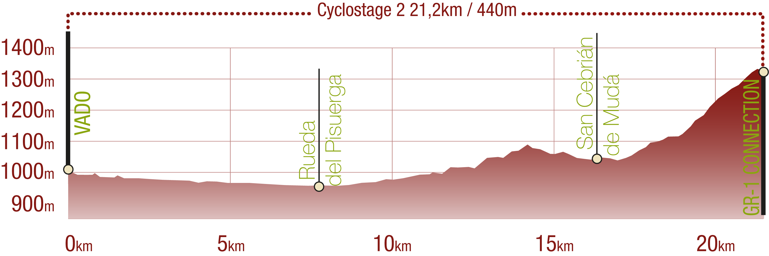
Coke Coal Route. Stage 3. Vado - Connection with GR-1 Road (San Cebrián de Mudá)
Description
Going into Fuentes Carrionas y Fuente Cobre-Montaña Palentina Natural Park
The last stage of the Coke Coal Route begins accompanying the Pisuerga river for more than a third of its course. Then, it runs north in search of the Palentinian Mountains and the Fuentes Carrionas and Fuente Cobre-Montaña Palentina Natural Park. This stage does justice to the trail’s name, since it offers the travellers the chance to discover more Romanesque treasures, such as the churches of San Cristóbal (Rueda de Pisuerga), San Juan Bautista (Vallespinoso de Cervera) and San Cornelio and San Cipriano (San Cebrián de Mudá).

Starting right where the previous stage of the trail ended, the third stage goes through the district of Vado and General Mola street and then Fuente Vad street. The trail leaves the town through the latter, after visiting the parochial church of San Sebastian, a Gothic building restored and expanded during the Baroque period. Leaving the last houses behind, the traveller can climb the rocks on the right to access a viewpoint offering great panoramic views of Vado and the mountain massif in the background.
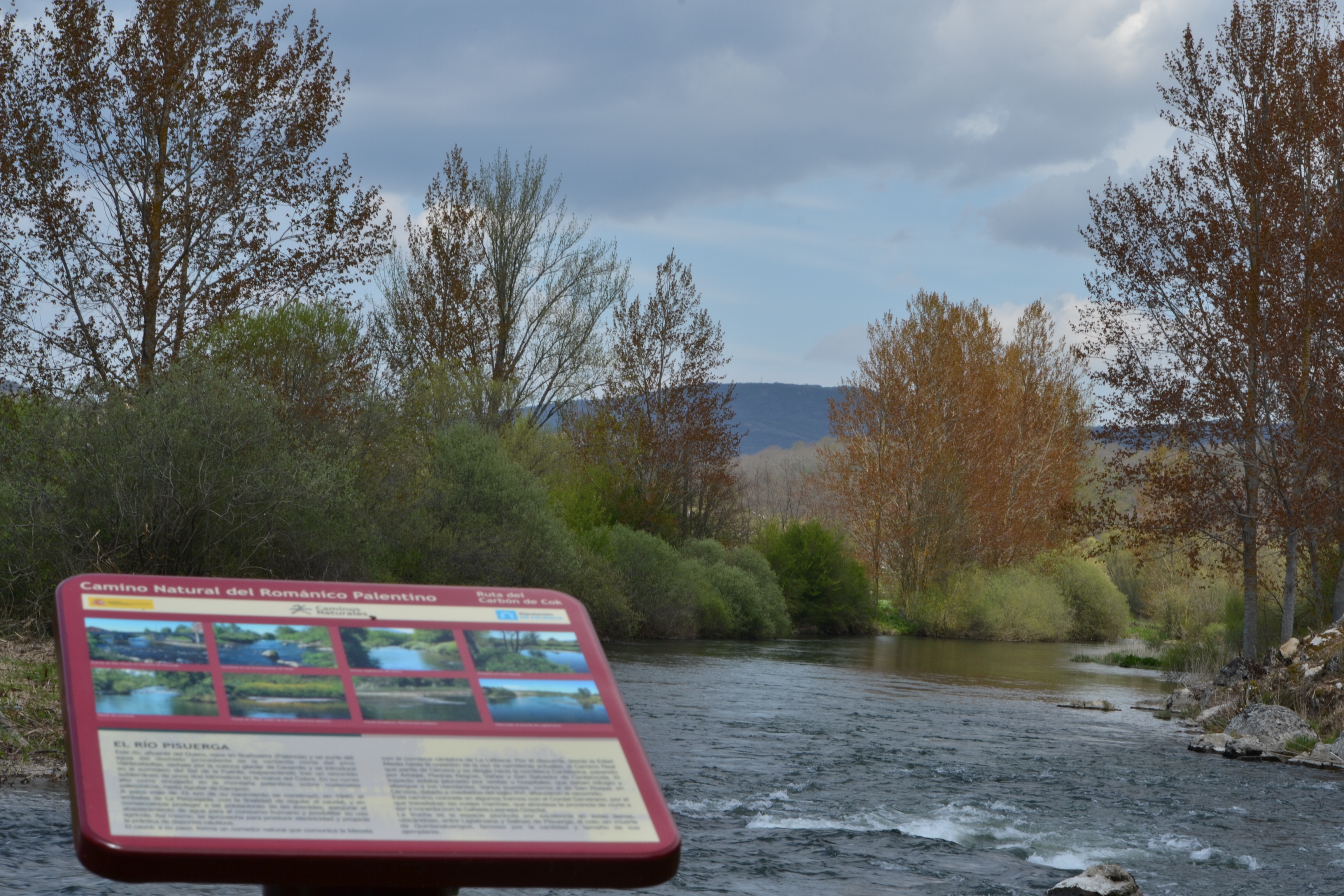
The path runs along the Pisuerga river for the next eight kilometres, allowing the traveller to discover a new type of landscape: the gallery forest. Willows, elms, and especially poplars will accompany the travellers for this stretch of the trail, allowing them to admire the Pisuerga river when the track approaches it or when the forest is less thick. At one point, just near a bend of the river, there is an information panel providing additional information on this tributary river of the Duero.

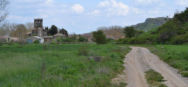
Farther ahead, a fork is reached where a branch crossing a bridge over the Pisuerga river leads to Ligüerzana. From this point, the trail goes eastwards, getting away from the river for a while and going among crops and meadows where cattle graze. After a few kilometres, the route passes by Quintanaluengos, another district of Cervera which can be accessed from some of the following crossroads. This dirt path eventually ends next to a recreational area in Barcenilla de Pisuerga, whose church, and particularly its high tower, are almost visible from Quintanaluengos. This church, Nuestra Señora de la Asunción, dates back to the 16th century, although it has a Romanesque baptismal font. The trail then leaves the church on the left and continues through a street opposite the area where the travellers have just come from.

This street arrives in a square where the travellers must take a bending street to the left. Then, a path on the right must be taken, crossing a dry branch of the Pisuerga river that used to serve a currently abandoned hydroelectric power station. Later on, the route goes through a pedestrian bridge over the river. The nature trail starts running northwest, now using a track near the river, with the gallery forest on the left and the crops and meadows on the right. A small trail departs from the right of this track, crossing the Mudá stream and going near a poplar grove, a football field and a rest area on the way towards the town of Rueda de Pisuerga.
The trail enters this town near the parochial church of San Cristóbal. Although it was modified in later centuries, this church still has the foundations of its unique nave and its façade from the 12th century. The route then leaves the town after crossing the CL-626 road, following a street on the left which immediately becomes a dirt path ending in another path where the travellers must turn right. Finally leaving the Pisuerga river behind, the path enters a new landscape, running among hills and valleys carved by streams; among bushes, meadows, durmast oak and Pyrenean oak forests (Quercus petraea and Q. pirenaica). Almost half a kilometre after leaving Rueda, the route crosses the Vallespinoso stream, which will accompany the travellers on their way towards the namesake town. As the route approaches this town, the travellers will see the hermitage of Nuestra Señora del Valle on top of a small hill on the left.
The route enters Vallespinoso de Cervera through the south of the town, getting into a square with a rest area, a basin and a livestock crush. Although the path goes through the town, following the street to the left of this square, the traveller will find the church of San Juan Bautista, from the 14th century, right in the centre of this small town.
The nature trail leaves the town following the PP-2126 road for a few metres, then going on a gravel track on the right, after crossing a stream. Before leaving the town, the traveller can visit the aforementioned hermitage of Nuestra Señora del Valle, about 600 metres following the road south.

Always with the same stunning landscapes on sight, the route enters an area of old mining tradition, mainly of coal. However, the mines are closed today, so the industry has now shifted towards tourism activities.
A mine which can be visited by tourists, as the one which already exists in Barruelo de Santuyán, is being planned. The coal drying area in the mine of Barrio de San Miguel became an astronomical observatory known as “Mirador de las Estrellas”, or Stars Viewpoint.
The path from Vallespinoso and San Cebrián de Mudá is not as obvious as in other stretches of this stage, since there are three intersections where the traveller must change paths. However, they are well indicated so that travellers do not get lost. After the first intersection, the route goes over the Verruenza stream, and after the last change of direction, the traveller can see the “Mirador de las Estrellas” on the right. Then the route goes straight until it enters San Cebrian de Muda, the last town the traveller will visit during this stage and along the nature trail.

The route enters this town through Terreno street, turning right on the first intersection up to the City Council square. Before starting the last stretch of the trail, the traveller can cross the PP-2125 road and visit the church of San Cornelio and San Cipriano, the last Romanesque church along the Coke Coal Route. This building dating back to the 13th century is located on a promontory overlooking the town and it was declared a Site of Cultural Interest in 1993.
The route leaves the square following Rosario street, which becomes a dirt track soon after leaving the last houses of San Cebrián behind. The path goes up in what is one of the hardest parts of the trail. Later on, 1.5 kilometres after the town, a branch leads to the Nature Reserve and Interpretation Centre of the European Bison. A few metres ahead, the nature trail also enters the Fuentes Carrionas y Fuente Cobre-Montaña Palentina Natural Park, the meadows and the scrub being replaced by a thick oak forest.
")
For the last 2.5 kilometres of this stage, the trail keeps going up through the oak forest, reaching the highest point of the Palentinian Romanesque Nature Trail (1,340 m). The peak Valdecebollas (2,143 m), close to the source of the Pisuerga river, is clearly visible from the clearings left by trees. This is particularly true at the end of the trail, a mountain pass where the Coke Coal Route crosses the GR-1 path, which the traveller can take, going down and left, to arrive in the nearby town of Herreruela of Castillería.
Sites of interest
Puntos de interés
Culture
Infrastructure
Municipality
- Vallespinoso de Cervera
- Mudá
- San Cebrián de Mudá
- Rueda de Pisuerga
- Vado
- Barcenilla de Pisuerga
- Ligüérzana
- Quintanaluengos
Orography
Profile

 Harshness of natural environment
- 1. The environment is not risk-free
- 2. There are more than one risk factors
- 3. There are various risk factors
- 4. There are quite a lot of risk factors
- 5. There are many risk factors
 Guidance along the route
- 1. Well defined trails and crossings
- 2. There is a clearly marked trail and signage
- 3. Requires the identification of geographic features and cardinal points
- 4. Requires off-path navigation
- 5. The trail is interrupted by obstacles that have to be gone around
 Route difficulty
- 1. Walking on a flat surface
- 2. Trails with different types of path
- 3. Walking on stepped paths or irregular terrain
- 4. The use of hands or jumping over the terrain is necessary
- 5. The use of hands is required to progress
 Amount of effort needed
- 1. Up to 1 hour of continuous walking
- 2. Between 1 and 3 hours of continuous walking
- 3. Between 3 and 6 hours of continuous walking
- 4. Between 6 and 10 hours of actual walking
- 5. More than 10 hours of continuous walking
(Calculated according to the MIDE criteria for an average excursionist with a light load)
Highlights
Further information
Nature Reserve and Interpretation Centre of the European Bison
The Nature Reserve of the European Bison (Bison bonasus) is located on a plot of 20 hectares of oak forest and meadows. It offers its visitors the opportunity to see several specimens of European bison in semi-freedom, and to find out more about them at the Interpretation Centre. The main goal of this project is the recovery of this animal, because there have not been any free European bison in the world since 1927.
Mirador de las Estrellas
The “Mirador de las Estrellas”, or Stars Viewpoint, is located in a former coal drying site dating back to 1956. It was refurbished in 2006 as an astronomical observatory, allowing for its preservation as a significant example of industrial architecture. This building is intended at spreading the history of the mining area and understanding the work done by miners.
Pisuerga River
This tributary of the Duero river has its source in the glacial valley of Covarrés, between the peak Valdecebollas and the Sierra de Híjar, in Sel de la Fuente, near the town of Brañosera (Palencia). After flowing underground for 3,000 meters, it reappears iatn Fuente del Cobre (Cueva del Cobre). In its upper course, it runs along the Palentinian mountains up to to Aguilar de Campoo, flowing along the Palentinian Romanesque Nature Trail when going through the town of Cervera de Pisuerga and Alar del Rey.
This famous trout river has a catch-and-release fishing area between Ligüerzana and Salinas de Pisuerga (Preserve of Quintanaluengos), which is renowned for the number and size of its specimens.
Multimedia


Downloads

GPS Downloads


Documents

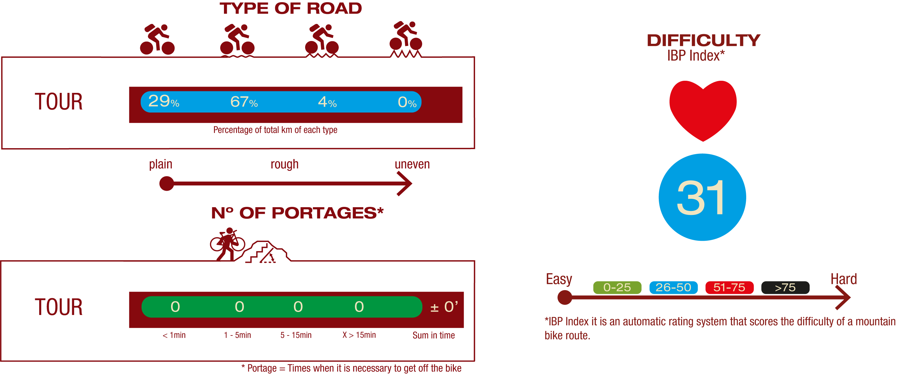
Cyclability
PROFILE
TYPE OF ROAD, PORTAGES & DIFFICULTY
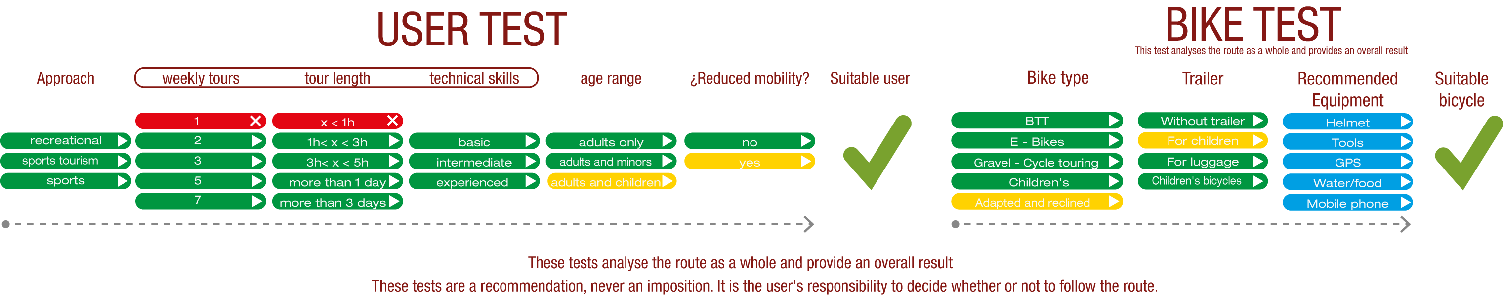
TEST
SAFETY RECOMMENDATIONS
- Sections shared with hikers.
- Transit through the centre of some population centres.
GENERAL RECOMMENDATIONS
- Find out about the technical aspects of the route and the weather on the day.
- Take care of the environment. Take care not to disturb animals or damage vegetation. Respect private areas.
- You must give priority to pedestrians and comply with general traffic rules.
- The environment in which you will be riding is open, free to move around and an area where many activities are carried out (sporting, forestry, livestock and agricultural activities). Always have an understanding, prudent, responsible and respectful attitude.