Net of Natural
Trails

Stage 6: Villamayor - Espinaredo
Description
A window on Piloña
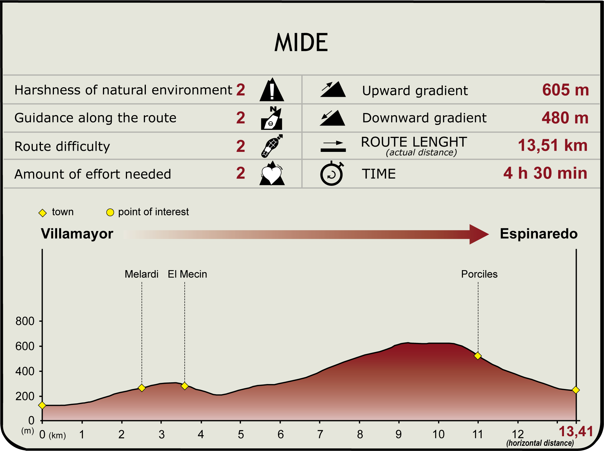
Still in County Piloña, the Nature Trail runs south from the town of Villamayor to Sierra Bedular. The route to Espinaredo, a town situated on the fertile plain of the River Infierno, and known for its “hórreos” (granaries), offers extraordinary views of the county, including the Mount Infiesto and neighbouring mountain ranges of Sueve, Aves and Sellón.

The route begins in the main square of Villamayor, located at the edge of the village, where an information panel on the section stands. It then veers right towards Torn and Rodiles. Before starting on the route, it is advisable to visit to the Romanesque church of Santa Maria, of which only the apse and part of the main nave remain. The temple was part of a now-defunct, 12th century Benedictine nunnery, closed in the fourteenth century by the Bishop of Oviedo for unseemly and licentious behaviour. The nave of the church was demolished in the nineteenth century, replaced first by a prison, then a school.
From Villamayor's square, the route continues along a paved road, following the directional signs, then turns off onto a track, after crossing a small bridge over the River Cueva and past several houses.
The route climbs gently, bounded on the left by a small oak (Quercus robur) and chestnut (Castanea sativa) grove, and by meadows on the right. The Piloña River floodplain can be seen through the trees.

When the track ends, the route continues its climb along a road, following the directional signs, towards Melardi. Inside the town, following the signs, the route continues in a moderate climb along a track towards the village of Valle.
Once in Valle, the track winds down through the narrow streets, amidst stone “hórreos” and houses, with the church of Santa María Magdalena to the left.
At the opposite edge of Valle, the route continues downhill by road, crossing a small bridge whence an old stone mill can be seen on the riverbank, then climbs through meadows and pastures until it reaches the neighbourhood of Taradiellu in Cardes.

Immediately after, the route continues along a gravel track in a steep climb to Sierra Bedular. It traverses first through pastures, then oak, birch and chestnut forests, as well as fern, heath and gorse patches, before crossing the Saliencia canal. Wonderful views of the Infiesto, and the mountain ranges of Sueve, Aves and Sellón can be seen during the climb.
Once on the hillock known as La Tayada, shortly before reaching Porciles, the dirt track begins to descend at the spot where the signs indicating the GR-105 trail also stand. The route continues to climb up to a water tank, from where the road runs along a concrete track.
After crossing Porciles, the track joins the road and descends through meadows and small chestnut and oak forests to Espinaredo, a town known for its many “hórreos”. Following the signs, the route ends next to the village church, where the end panel is located.
Sites of interest
Puntos de interés
Culture
Municipality
Hostel
Profile

Highlights
Further information
Oculatio's Stela
In the Valledal neighbourhood of Villamayor is a house that stands out for its elegance: the Casa Pastrana. A fine example of a typical farmhouse, situated in a neighbourhood studded with major architectural landmarks, including numerous ancient “hórreos”, porticoed corridors and galleries.
Casa Pastrana is rectangular in shape, with a carved wooden corridor, “panera” (granary) and front courtyard. Its façade, with a semicircular doorway, has decorative elements different from those used in local traditional architecture. These elements are four Romanesque corbels from the nearby Romanesque church of Santa María and the Stela Oculatio, a river stone that provides evidence of Roman occupation.
This large boulder on the façade was found along the River Piloña. It has a Roman funerary epigraph with an inscription, where one can make out the name of the deceased, and the name of a clan -the Viromenici, that inhabited the neighbouring county.
The “hórreos” of Espinaredo
At the foot of Sierra Bedular, prelude to the mountain ranges of Aves and Giblaniella, in a well-irrigated fertile agricultural plain, lies the town of Espinaredo or Espinaréu, divided by the River Infierno, which flows into the River Piloña, at the foot of Mount Infiesto.
Recent archaeological findings in Cueva de Aviao (Solutrean and transition to Mesolithic) and Peña Ferrán (Neolithic and Roman) seem to prove that the inhabitants of Espinaredo lived for centuries in compact settlements.
The compounds consisted of several one-storey houses, with wooden balconies and whitewashed stone walls, which formed a harmonious ensemble that was restored in 1990. The large number of traditional “hórreos” (in excess of 30) that are strewn around its streets powerfully attracts the attention. Most of the “hórreos” that Espinaredo is famed for were built between the 17th and 18th centuries. They are still in good repair and barely decorated, although a few still have an isolated motif, such as triangles, cubes and crosses, in the “colondras” or carved on the “liños”.
Espinaredo's parish church, Santa María de las Nieves, an 18th century, folk-style building, stands on the banks of the River Infierno, next to a yew (Taxus baccata). It has a Latin cross plan, a straight apse and a half-barrel vault, belfry and side portico, as well as semicircular arches that open onto side chapels and a tall ashlar belfry. The temple suffered alterations in the nineteenth and twentieth centuries.


