

Net of Nature
Trails

Stage 1: Alquézar-Colungo-Alquézar
Description
Historical heritage in the surroundings of the canyons of the river Vero
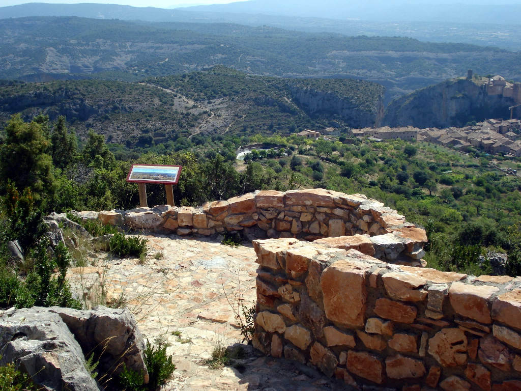
The first stage of the Somontano Nature Route is a circular path that starts and ends in the town of Alquézar. Along the way, you'll discover the area surrounding the river Vero and its tributaries nestling between limestone cliffs, and enjoy the heritage to be found in villages such as Alquézar, which was declared a Historic Site, and Colungo. There is a rest area next to the platforms of the station of Malón; from there you can see the village on a hilltop. The remains of a castle courtyard can be seen in the highest part of the village, from where you can get a good view of the river plains.
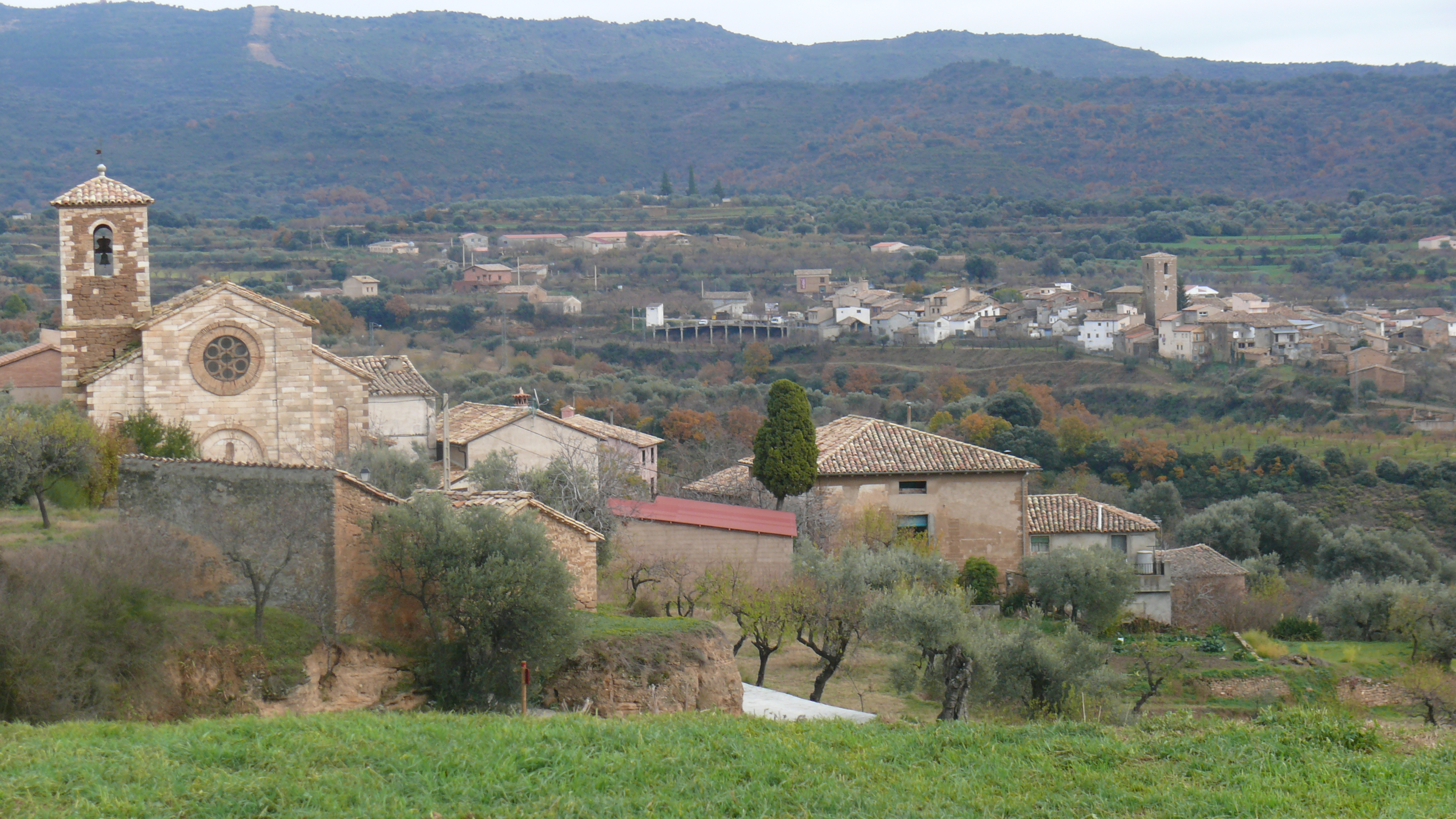
This first stage of the Somontano Nature Route of Barbastro starts in Alquézar, near the parish church of San Miguel Arcángel. Before setting off, take a moment to look around Alquézar, a historical town (dating back to the 9th century) that was declared a Historic-Artistic Site in 1982. The most notable feature, standing out from a hilltop, is the collegiate church of Santa María la Mayor. The first kilometres of this stage coincide with Stage 2, which takes you to Las Almunias de Rodellar.

The Route immediately enters the historical quarter of the town, running through cobbled streets surrounded by picturesque buildings for several hundred metres before leaving the town and heading north.
Then you come to a slope that heads in the direction of the hermitage of San Gregorio, passing close by a reservoir, the aljibe de San Gregorio. You pass along a broad forested track right at the diversion that takes you to the hermitage. Although the route continues along the forest trail, it's well worth paying a visit to the hermitage to see the fantastic views of Alquézar and the canyon of the river Vero. Another option is to pass by the church and keep walking until you reach a bird observatory, from where you can see carrion eating birds that come here to feed off the nearby 'muladar' (midden).

Continuing along the Nature Route through the forest trail for another kilometre, you come to a fork in the path. At this point Stages 1 and 2 separate. If you continue on the trail, you'll be taking Stage 2, but if you want to continue with this stage, take the narrower trail that heads off to the right.
This part of the trail follows a traditional water course that takes you to an area called the Balsas de Basacol, a group of ancient Moorish aljibes (water cisterns) that were used to keep the water that supplied Alquézar. The area was rehabilitated, tables and seating were installed, and is now a popular location for picnics and hiking.
Heading south, you leave the Balsas on a trail that goes upwards to a natural esplanade, from where another trail takes you down towards Alquézar.

From here there is a wonderful view of the southern part of the town, and of the canyons of the river Vero to the north east. The route continues along a trail that heads down to the river Vero. Once there, you cross the river over the bridge of Villacantal, a stone built bridge with two arches and the unusual feature of being built at an angle. At the bottom of the gorge of the Vero there are some impressive rock formations surrounding the canyon, which explains why lovers of canyoning pass through here on their way down from the beautiful village of Lecina.
The route heads upwards to reach the other side of the canyon of the river Vero. After an uphill walk of about one kilometre, you come to a pass from where you set off along a small path that takes you to the shelter of Regacens, which was once used as a corral and still has some examples of rock art. The trail itself, however, continues eastwards towards Asque. You reach this small village, which forms part of the municipality of Colungo, by heading down towards the gorge of Malpaso and going back up the other side.
")
The Route enters Asque along the main street until you come to a plaza, where it splits. To continue along the route, you need to take the east route to leave Asque and head off towards Colungo, or you can go west to return to Alquézar. If you set off towards Colungo, the route goes down to the gorge of Fornocal, where you cross over the bridge of El Diablo. Probably of medieval origin, this stone built bridge with a pointed arch gets its name from the legend that building it was so difficult that it must have been the work of the Devil himself, who left a mark on the mortar that is still fresh.
After an upward stretch of one kilometre from the gorge, you finally come to Colungo. Like Alquézar, this small village dates back to the Middle Ages. It also has a centre of rock art with information about the cultures that lived in the area surrounding the river Vero. It is also the setting off point for guided visits to the rock shelters and caves in the region of the Somontano de Barbastro, organised by the Cultural Park of the river Vero.
After wandering around the picturesque streets of Colungo, if you want to continue along the Nature Route you have to head back towards Asque, and continue in the direction of Alquézar along a stretch that runs alongside section GR 1.1 of the GR 1 historical route between Girona and Araba/Álava.

About 3 km of a gentle downwards slope take you back to the canyon of the river Vero, where you get another panoramic view of Alquézar, this time from the south. The trail slopes more sharply on its way to the river, where you come to the historical bridge of Fuendebaños. This is a good place to appreciate the importance of the Vero in the development of Alquézar, since here you can see some mills that were once here just after crossing the bridge.
Now you come to an upward slope that heads up the canyon and comes to the starting point of the Route in Alquézar. Along the way, after about half a kilometre, a diversion to the right connects with the end point of the routes of the Vero, an impressive trail where you can walk between the rock faces of the river canyon, sometimes directly above the water along some aerial walkways anchored into the rock. You need to make a reservation beforehand if you want to do this route (for more information, contact the tourist office at Alquézar or go to http://pasarelasdealquezar.com/es_ES/).
If you want to complete the 17 km of the first stage, you just have to continue upwards for another half a kilometre to come the starting point next to the parish church.
Managing Entities
Sites of interest
Puntos de interés
Information
Infrastructure
Municipality
Profile

 Harshness of natural environment
- 1. The environment is not risk-free
- 2. There are more than one risk factors
- 3. There are various risk factors
- 4. There are quite a lot of risk factors
- 5. There are many risk factors
 Guidance along the route
- 1. Well defined trails and crossings
- 2. There is a clearly marked trail and signage
- 3. Requires the identification of geographic features and cardinal points
- 4. Requires off-path navigation
- 5. The trail is interrupted by obstacles that have to be gone around
 Route difficulty
- 1. Walking on a flat surface
- 2. Trails with different types of path
- 3. Walking on stepped paths or irregular terrain
- 4. The use of hands or jumping over the terrain is necessary
- 5. The use of hands is required to progress
 Amount of effort needed
- 1. Up to 1 hour of continuous walking
- 2. Between 1 and 3 hours of continuous walking
- 3. Between 3 and 6 hours of continuous walking
- 4. Between 6 and 10 hours of actual walking
- 5. More than 10 hours of continuous walking
(Calculated according to the MIDE criteria for an average excursionist with a light load)
Highlights
Further information
Alquézar
The small town of Alquézar (from the Arabic al-Qasr, fortress), took shape around the skirts of the mountain where the fortress that gave it its name was built. The fortress itself dates back to the 9th century and was one of the main defensive bulwarks of the Andalusi region of the Barbitania.
Taken by Christians in the 11th c., the town's population began to increase and with that the town began to spread out beyond its walls, to form what is now the current town structure (Burgo Nuovo Alquezarensis). The only remaining inhabitants of the castle were clerics, which led to its transformation into the collegiate church of Santa María la Mayor, one of the most recognisable sights of Alquézar. A notable feature of this religious complex is the 16th c. church, containing a richly coloured altarpiece, chapels, the organ and the Cristo de Lecina, a 13th c. carving. Another feature well worth seeing is the cloister, unique in Aragon for conserving all its frescos, painted between the 14th and 18th centuries.
A visit to the other parts of the town is also highly recommended, where you can take a walk along the typically medieval streets interconnected by narrow winding lanes. The buildings have maintained the traditional architecture of local stone, adobe, brickwork and mud walls, and some houses date back to the 14th and 15th centuries. Two of the three gates that gave access to the town are also still preserved. The historical quarter of Alquézar was declared a Historic-Artistic Site in 1982.
This walk through the history of the town can be completed with a visit to the “Casa Fabián” ethnological museum in a 17th century house on top of a medieval oil mill built into the rock.
But the town has a lot more to offer besides it rich historical heritage. Its central position in a natural setting of great beauty right in the heart of the Sierra and Cañones de Guara Nature Park, has transformed the town's economy, leading to a shift from dry land farming to the service sector and making it a starting point for a wide range of activities in rural and sports tourism such as hiking and canyoning.
Terminology in the canyons of Guara
Canyon: a narrow pass or deep gorge between two high mountains, in which rivers usually flow.
Badina: a pool or pond of water.
Ravine: a rupture in the land created by water currents.
Pool: a pond or cavity in the rock where water is retained.
Multimedia


Downloads

GPS Downloads


