Net of Natural
Trails

Stage 7: Villar de Cobeta - Huertapelayo
Description
From the mountain to the plateau
The dense pine forests that flanked the path make way to holm oaks and Spanish junipers, better adapted to the high temperatures and low rainfall found in Stage 7 of the Tagus Nature Trail.
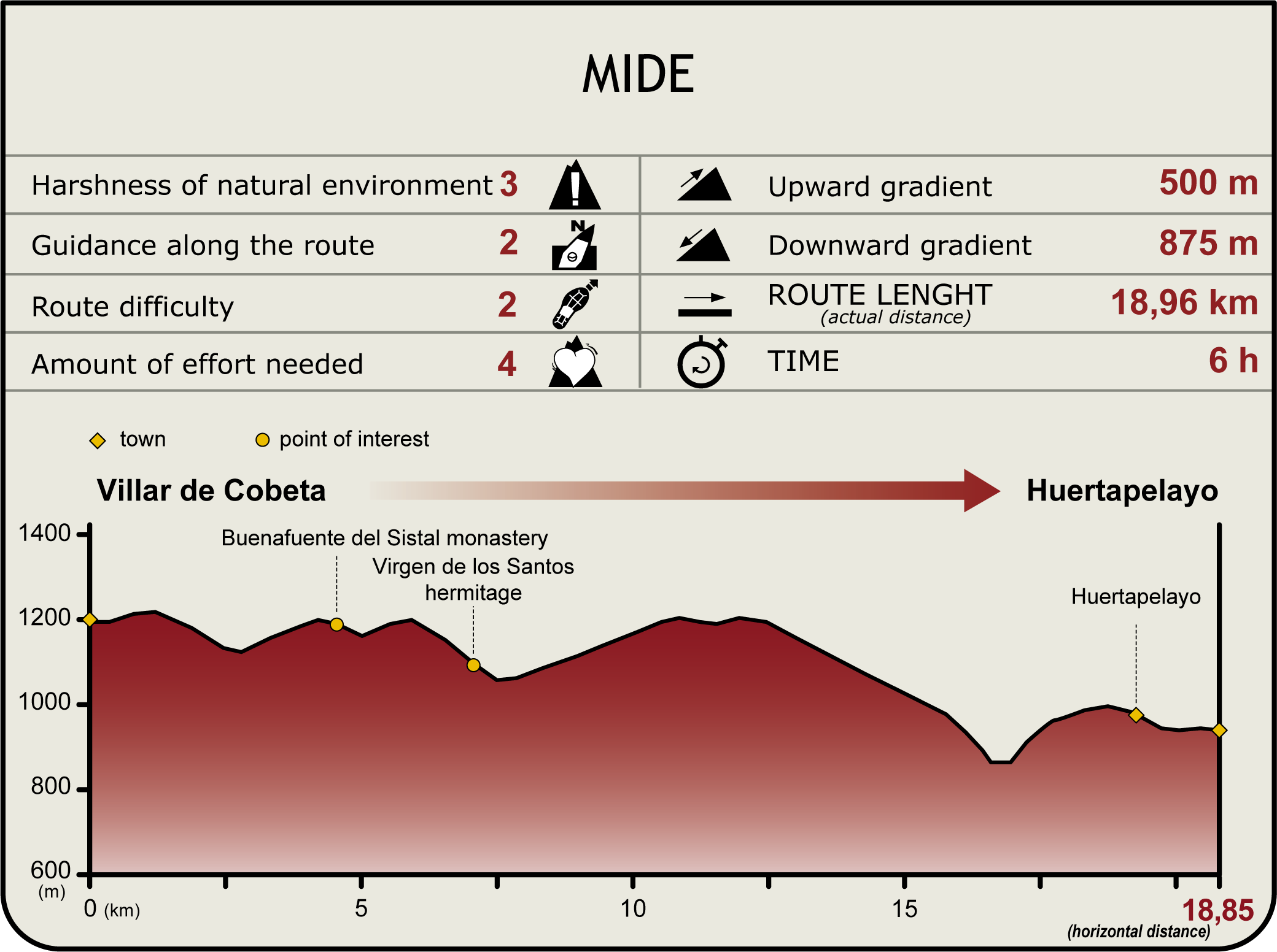
This Stage begins in the upper edge of Villar de Cobeta. During the first 450 m, the path runs along the CM-2113, then turns left to venture through several crop farms.
The Trail passes through a small juniper forest, crosses Los Molinos Ravine and reaches the CM-2113. It continues along a narrow path parallel to the road. It gradually gains height for about 1.25 km until the path bears to the left, and starts a steep descent towards the town of Buenafuente del Sistal.
The route continues up steep slopes through an area flanked by Mediterranean cypresses (Cupressus sempervirens) until it reaches a wide track. An arrow indicates that the town of Huertapelayo, the endpoint of this Stage, is less than fifteen kilometres away.
The track descends to a small rest area with tables and a fountain, close to the shrine of Virgen de los Santos. However, the route veers right towards an interStage, and continues along the right track that climbs up through the forest.
It proceeds along this path for a few kilometres until it reaches a wide forest track, on which it continues until the end. After a number of bends, an arrow indicates that the Nature Trail will turn right to descend, skirting around farms, towards a river valley covered with boxwood (Buxus sempervirens). The route has advanced about seven kilometres from the rest area next to the shrine of the Virgen de los Santos.
The stony path leads to the River Tagus, which it crosses via the Tagüenza Bridge. The bridge, built in the early 1940s, has a single arch and is literally embedded in the rock, without any other foundation but the slender walls that confine the river.
Having crossed the bridge, the path climbs up a scree, skirting around the peak of Cabeza la Fuente, to merge with a track leading to Huertapelayo. This last stretch is common to Stages 7 and 8.
If you wish to proceed directly to Stage 8, take the track to the right; however, if you want to reach the end of Stage 7, take the path to the left from where you can enjoy amazing views of the valley. Further on, the path crosses over Vega Brook towards downtown Huertapelayo. As you have seen for yourself, the beauty of the landscape has been enduring throughout this Stage, which runs almost entirely through the Alto Tajo Nature Park, Site of Community Importance (SCI) and Special Protection Area (SPA) for Birds.
Entidades Gestoras
- Ministerio de Agricultura, Pesca y Alimentación
Enlaces de interés
Puntos de interés
Culture
Infrastructure
Municipality
Orography
Hostel
Passport
Profile

Highlights
Further information
Wildlife in wheat fields
While ploughing the land for sowing, hundreds of small invertebrates become exposed to the mercy of Northern lapwings (Vanellus vanellus), Wagtails(Motacilla alba), European Starlings (Sturnus vulgaris), Eurasian Jackdaws (Corvus monedula) and European White Storks (Ciconia ciconia).
The stones removed and stacked create "majanos" where rabbits (Oryctolagus cuniculus), foxes(Vulpes vulpes), least weasels (Mustela nivalis) and Little Owls (Athene noctua), can build their nests.
In addition to crops, different species thrive on the boundaries and slopes, producing seeds and fostering the growth of insects. These resources are used by Northern Wheatears (Northern wheatear), Meadow Pipits (Anthus pratensis), Eurasian Skylarks (Alauda arvensis) and small rodents, which in turn attract larger predators such as Northern Harriers (Circus cyaneus) and Eurasian Hobbies (Falco subbuteo).
Buenafuente del Sistal Monastery
It is the only active Cistercian monastery in the province of Guadalajara. This monastery, founded in the Middle Ages, belongs to the Canons Regular of St. Augustine. Over time, it became property of the Cistercian order. Although it was never classified as an independent monastery, in the Middle Ages, it was registered as a farm or a chapel owned by the Monastery of Ovila, the great abbey located downstream on the right bank of the Tagus.
The monastic compound consists of a monastery, a temple and a sort of hamlet with a nursing home, gym, youth centre and a multipurpose building which provides different services to the community.
Huertapelayo
It may be regarded as a "town reclaimed from the rocks". This becomes immediately apparent with its spectacular "gateway" to the town. The single-level, masonry parish church, built in the seventeenth century, and its altarpiece are of particular interest.
Multimedia
Downloads
GPS Downloads
Documents
Cyclability
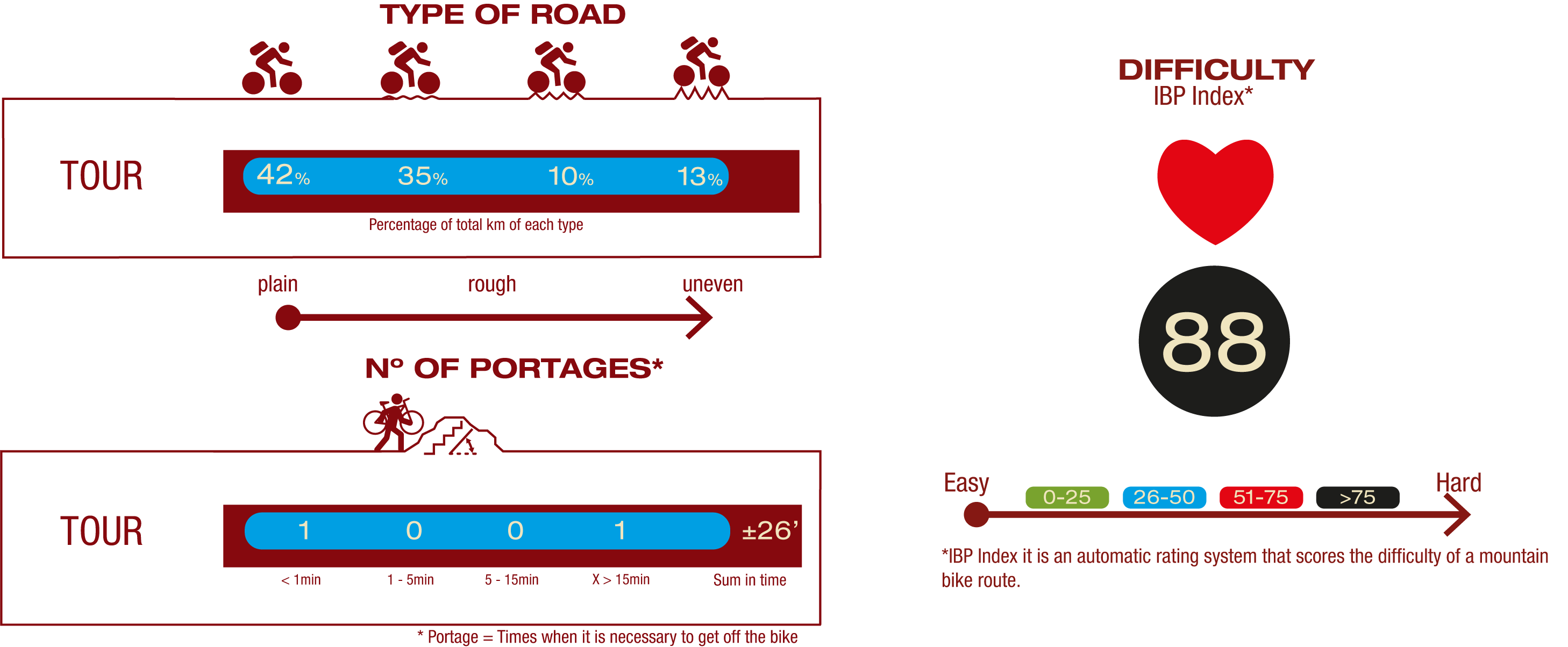
TYPE OF ROAD, PORTAGES & DIFFICULTY
SAFETY RECOMMENDATIONS
- Sections shared with hikers.
- Transit through the centre of some population centres.
- In cyclostage 1 you will cross a straight tarmac road. Take extreme caution, look for a straight section and proceed to cross at the said straight section.
- In cyclostage 3 you will walk along a stretch close to the riverbed. This area is prone to flooding during the flood season.
GENERAL RECOMMENDATIONS
- Find out about the technical aspects of the route and the weather on the day.
- Take care of the environment. Take care not to disturb animals or damage vegetation. Respect private areas.
- You must give priority to pedestrians and comply with general traffic rules.
- The environment in which you will be riding is open, free to move around and an area where many activities are carried out (sporting, forestry, livestock and agricultural activities). Always have an understanding, prudent, responsible and respectful attitude.


