Net of Natural
Trails

Stage 6: Zaorejas - Villar de Cobeta
Description
In the midst of pines and Spanish junipers
The route leaves the rocky canyons behind, venturing into woodlands. Pines and Spanish junipers flank the Nature Trail during this sixth Stage.
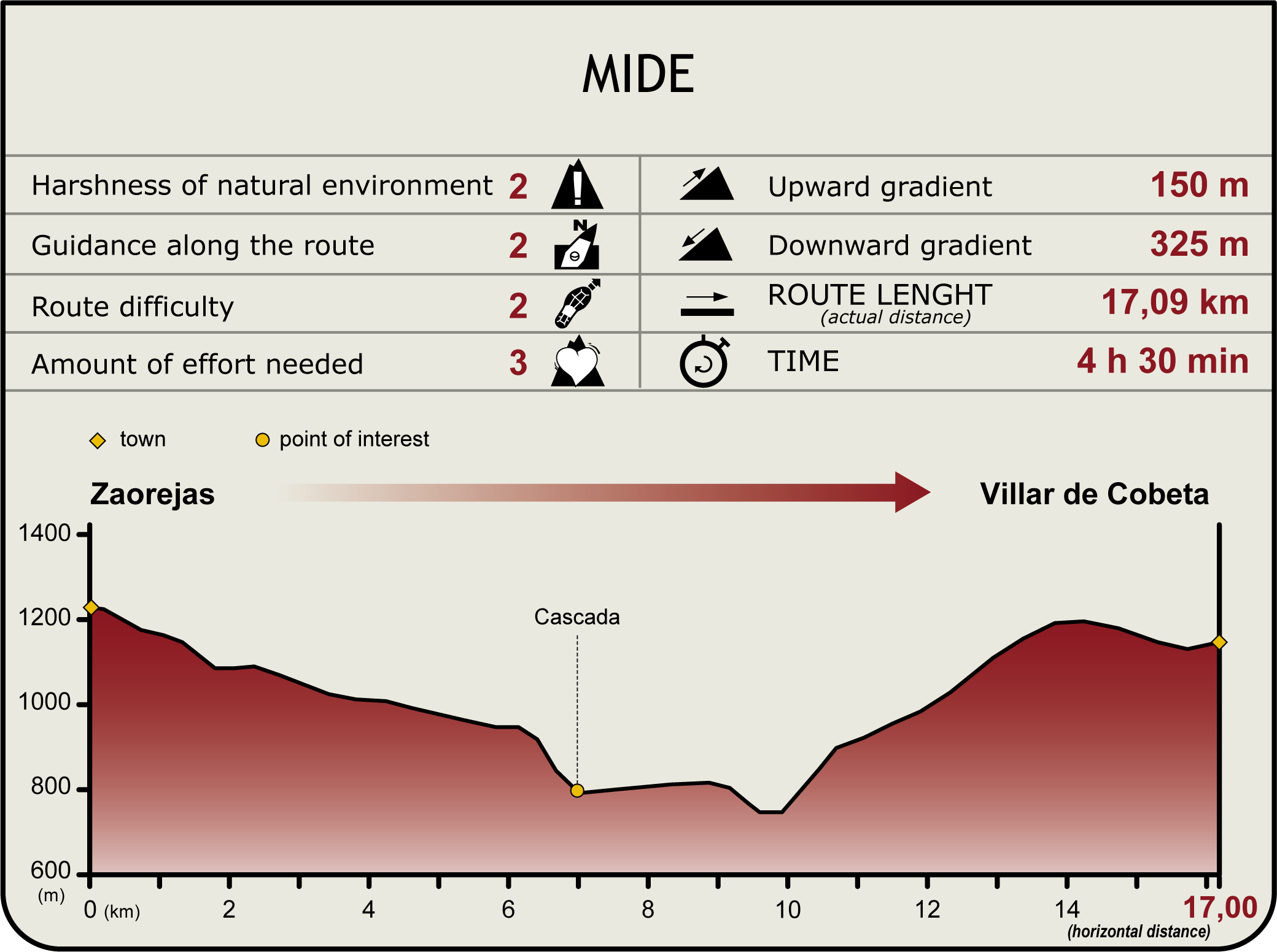
The first 5-kilometres of Stage 6 (start) overlap with the end of Stage 5 at the town of Zaorejas. Those who have already completed Stage 5 will have to retrace their steps back through the farm until Ciño Negro Ravine where, once near the banks of the Tagus, the route continues along the wide track used in Stage 5.
The path veers onto the left road at the interStage, which now forms part of Stage 6. The seasonal tuff waterfall carved by the Ciño Negro Brook can be seen depending on the time of year.
One kilometre further from the interStage, the Trail reaches the CM-2015 and turns left, leaving to the right one of the largest tuff constructions in Europe. During approximately 600 meters, the Trail runs parallel to the paved road; hence, caution should be exercised. The Stage then veers off the paved road onto a track to the right leading to the Herrería bridge-dam.
After crossing the bridge over the Tagus, a sign warns of the dangerous conditions of this part of the route. The Trail narrows and climbs up a rocky hillside, leaving the river to the right. As the path gradually gains height, it veers away from the river. The views of the river and waterfall are spectacular, especially when seen from one of the natural viewpoints that overlook the canyon.
After climbing about 400 m along a meandering path, as the contour becomes gentler, the cliff and the views of the river are left behind.
The juniper (Juniperus communis), rosemary(Rosmarinus officinalis) and lavender(Lavandula stoechas), that covered the slopes give way to black pines(Pinus nigra) and small clusters of boxwood (Buxus sempervirens). Indeed, the Stage runs almost entirely through the Alto Tajo Nature Park, and entirely within the namesake Site of Community Importance (SCI) and Special Protection Area for Birds (SPA).
Caution should be exercised not to stray from the path as the trail is less defined, and the only signs are milestones and red and white GR marks. Three hundred (300) meters further on, the path arrives at a junction where an arrow indicates that the Trail continues to the left towards the CM-2113.
Once on the road, the Trail veers left and continues several kilometres parallel to a paved road. After 500 m, a sign indicates an offshoot road to Puntal de la Rocha viewpoint (2 km away) with excellent views of the mountain range.
The route ascends gradually but steadily until it reaches the heights of the moorland. The landscape here is dominated by Spanish junipers (Juniperus thurifera), the only species to survive the local weather conditions.
Leaving the juniper forest behind, the route reaches a fountain-basin and a sign indicating the end of the Stage at Villar de Cobeta.
Entidades Gestoras
- Ministerio de Agricultura, Pesca y Alimentación
Enlaces de interés
Puntos de interés
Culture
Geology
Infrastructure
Municipality
Orography
Hostel
Passport
Profile

Highlights
Further information
Spanish juniper forests
Spanish juniper forests are the remnants of the pre-glacial, steppe forests that had their heyday in periods with more arid conditions. This steppe heritage has enabled this species to survive low winter temperatures and summer droughts. Indeed, the largest forests are located in areas with harsh continental climate.
Juniper forests are more or less open. The Spanish juniper is a conical shaped, medium-sized, perennial tree, although the oldest specimens may grow to a height of up to 20 m. The savin juniper, typical of high-level moorlands, grows in clusters, creating a landscape known as “leopard skin”.
The forests date back to the Tertiary, about 80 million years ago, when the temperate climate in the Mediterranean began to wane. It most likely widely colonised much of the territory before the great African and European mountain systems came into existence. During the Quaternary, its range was much reduced, making these forests extremely valuable.
Other plant species that coexist with the Spanish juniper include holm oak (Quercus ilex), Portuguese oak (Quercus faginea), maritime pine (Pinus pinaster), Scots pine(Pinus sylvestris), black pine (Pinus nigra), Pyrenean oak (Quercus pyrenaica), gorse (Genista scorpius), thyme (Thymus sp.).
Multimedia
Downloads
GPS Downloads
Documents
Cyclability
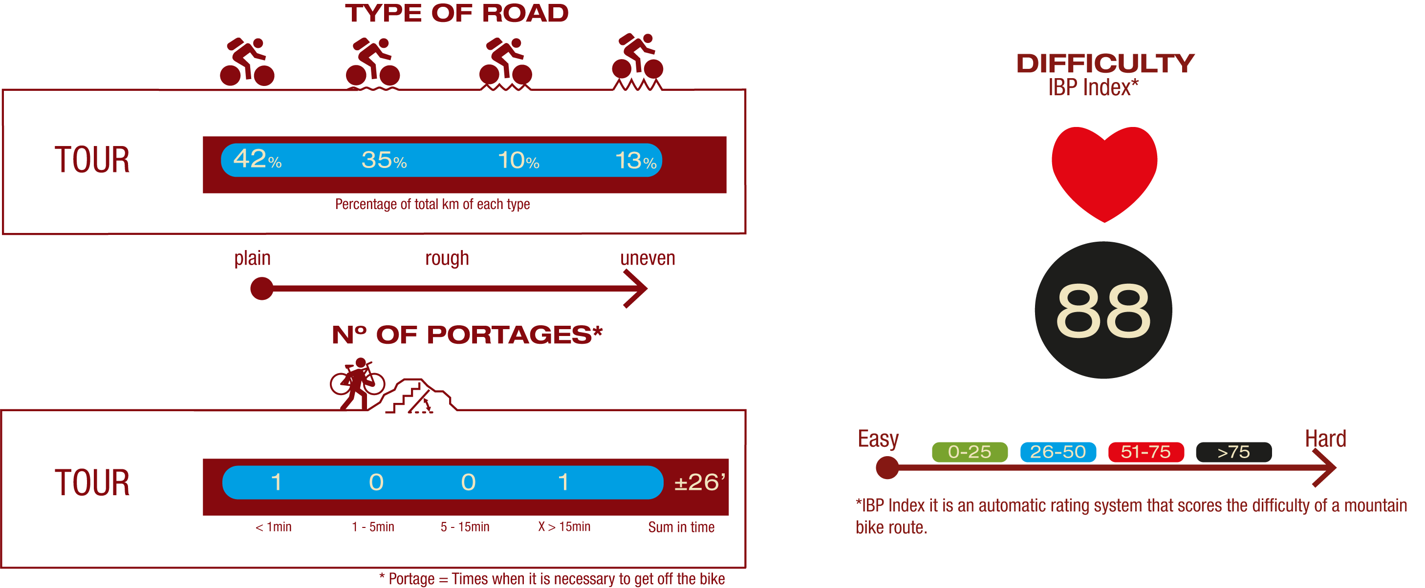
TYPE OF ROAD, PORTAGES & DIFFICULTY
SAFETY RECOMMENDATIONS
- Sections shared with hikers.
- Transit through the centre of some population centres.
- In cyclostage 1 you will cross a straight tarmac road. Take extreme caution, look for a straight section and proceed to cross at the said straight section.
- In cyclostage 3 you will walk along a stretch close to the riverbed. This area is prone to flooding during the flood season.
GENERAL RECOMMENDATIONS
- Find out about the technical aspects of the route and the weather on the day.
- Take care of the environment. Take care not to disturb animals or damage vegetation. Respect private areas.
- You must give priority to pedestrians and comply with general traffic rules.
- The environment in which you will be riding is open, free to move around and an area where many activities are carried out (sporting, forestry, livestock and agricultural activities). Always have an understanding, prudent, responsible and respectful attitude.


