Net of Natural
Trails

Stage 28: Aldeanueva de Barbarroya - El Puente del Arzobispo
Description
Roman remains along the Tagus
The Nature Trail leaves Aldeanueva de Barbarroya in a steady descent towards the flood plains of the Tagus, through holm oaks and granite blocks, passing by the Roman road of the River Use and the Azután Reservoir.

The route heads northwest from the lower part of Aldeanueva de Barbarroya, along the final stretch of Stage 27. Where both Stages intersect, the Trail turns left to continue along Stage 27. During the first part, the route overlaps with the Jara Green Track, which also passes through this town. Soon after, the routes go their separate ways, with the Tagus Nature Trail veering north, to the right, at the interseccion.
From here, one can see in the distance the breath-taking view of the Tagus lowlands. This route passes next to the municipal swimming pool and football pitch, where it once again reaches an intersection with the CM-4140 leading to the town of Aldeanueva. At this fork, the route turns right, towards the town, during 150 m, then turns 180° to run parallel to the road. This stretch is narrow, overgrown with shrubs, and quite complicated to pass; however, it only covers 700 m.

The route then ventures onto a track that turns right into fields of grain and a few scattered vineyards. Soon after, the landscape changes drastically with beautiful holm oaks (Quercus ilex) and granite boulders. The route is slightly bumpier, wedged between granite walls that mark the boundaries of the holm oak estates. The few intersection in this area are clearly marked.
The route is very pleasant and quite easy to walk, although it goes up-and-down frequently. The flood plains of the River Tagus can be seen throughout the route. About five kilometres from the last intersection with CM-4104, the route crosses to the opposite side of another road where the Roman road of River Uso begins.
The Roman road, whose original layout is visible, initially descends slowly, and then becomes steeper and narrower. If cycling, you may have to walk this part of the Trail owing to the large stones and narrowness at some points, which make it technically challenging. Regardless of whether you are walking or cycling, you will enjoy breath-taking views of the Azután Reservoir and the River Uso.
The Trail leaves this path at the intersection with the CM-4104, along which it continues for about 1.5 km. The route crosses a bridge over the River Uso, which appears restricted by a dam owing to the proximity of the waterfall.
The route moves away from the CM-4140 when it reaches a path to the right with a sign indicating the way to the Azután Reservoir spillway. The Trail passes across the reservoir dam with spectacular views of the surroundings.

It then winds along the right bank of the Tagus towards the TO-1194, then heads along its shoulder during 500 m. From here, the route changes directions several times, all clearly marked, skirting around irrigated land and livestock farms close to the town of El Bercial.
The road and the track merge again for 1.5 km, then the Trail continues to the left towards the river along a path that is increasingly narrow. Close to El Puente del Arzobispo, the path runs along a riverside walk that runs parallel to Frailes Creek, until it reaches the Bienvenida Bridge, which as its name suggests, is the entrance to the town. The endpoint of the Stage is near. From the streets closest to the Tagus, one can contemplate the monumental stone bridge that is the pride of the inhabitants of El Puente del Arzobispo.
Sites of interest
Profile

Highlights
Further information
Puente del Arzobispo
Franciscan Convent
According to the town's inhabitants, in bygone days, the convent was located one hundred paces from the town. Currently, it has been incorporated into the urban fabric. The image of Nuestra Señora de Majano, so-called because she appeared standing on a heap of stones to a sacristan from the nearby town of Alia, is venerated in the convent of the Discalced Franciscans. The church had five altars and an altarpiece. The residence of the Franciscan friars consisted of seventeen cells, two offices, two cloisters, a cave and a magnificent garden.
Stone bridge
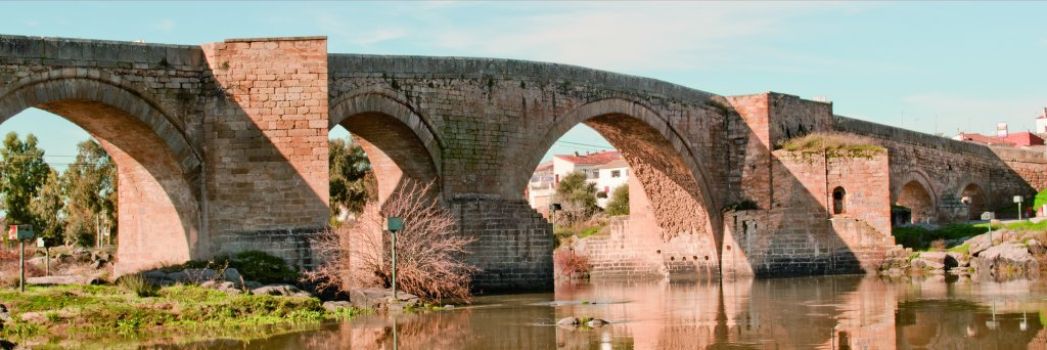
It was commissioned in 1380 by the then Archbishop of Toledo, and Duke of Estrada, Pedro Tenorio. It is made of granite and semi-circular arches that are smaller on the sides. The central arch, under which the river flows, is approximately 14.5 m from the water surface. Two sturdy, granite ashlar defensive towers stood on both sides of the central arches, but were torn down in the late nineteenth century.
Pillory
This Gothic, granite monument (15th century) is divided into five parts: stereobase, base, shaft, capital and pinnacle. The stereobase is divided into two torus, of which the second is ornamented with spherules. The square capital has two pearl-shaped ornaments and a protruding lion's head, reminiscent of the gargoyles of Gothic buildings. The pinnacle forms a pyramid with four pearl-shaped ornaments attached to the base, another four in the centre and one on each side, and finally, a larger pearl at the top. The pillory has a slender figure, and is one of the most valuable monuments of its kind in the province of Toledo.
Ceramics made in El Puente
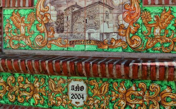
The ceramics manufactured in El Puente is characterised by landscapes and hunting scenes in green. Green goes hand in hand with yellow, orange-blue and, occasionally, light brown.


