Net of Natural
Trails

Stage 25: Malpica de Tajo - Talavera de la Reina
Description
Along the paths to Talavera
This Stage of the Nature Trail continues its course through the stunning landscapes of the Tagus valley in La Mancha. The entrance into Talavera is via a comfortable and beautiful promenade used in bygone days to travel to the neighbouring towns, the so-called "Vereda de Talavera".
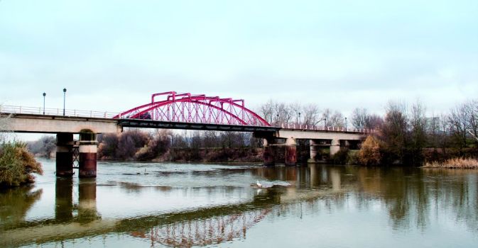
The route leaves Malpica via the main access road TO-760, which crosses an iron bridge on the Tagus. A last glimpse of the monumental castle of Malpica can be seen from here.

The path continues until an interStage where a sign points to the left towards Talavera. There is another sign that indicates that the town of Puebla is upstream to the right.
The Trail proceeds along the right bank of the river, amidst cornfields and lush vegetation that thrives from the moisture of the Tagus. This Stage heads west along the right bank of the river. It is worth mentioning that the Stage initially traverses through the “Río Tajo en Castrejón, Islas de Malpica de Tajo y Azután” SCI (Site of Community Importance) and SPA (Special Protection Area for Birds).
The signs along the route point out interesting geological features, including the Val de Mora Ravine, near the river. The towns of Cebolla and Montearagón can be seen in the distance, as well as their olive groves and farmland.
The path ventures through croplands and olive groves, as well as almond and fig orchards, which illuminate the landscape with a bright palette of colours. Occasionally, one can get a close-up view of the river and the abundant fauna through a gap in the bushes.
Several kilometres further on along this Vereda de Talavera, is a junction next to a bridge that one must cross to continue parallel to the busy CM-4000 road. It gradually drifts away from the road and ventures into croplands with a circular irrigation system.
The route drifts back to the road, along which it runs for a few metres. One can rest at a rest area equipped with picnic tables and an information panel when the route approaches the river for the last time before reaching Talavera de la Reina.
As the Trail approaches its destination, one can see in the distance a suspension bridge and Talavera's industrial park, which reminds us that the "City of Ceramics” is near. The path avoids the industrial park by taking the so-called "Cordel de Ganados" via a wide track. This stretch heads towards the access road to Talavera, alongside which it runs 200 m, i.e. the length of the bridge over the River Alberche. Caution should be exercised due to heavy traffic. On the opposite end of the bridge, the Trail turns 90° to the left, and continues along a pedestrian path and "bike lane”.
The arrival to the city is via a comfortable promenade along the River Tagus, which is several kilometres long and crosses Palomarejo Street, Madrid Avenue and Castile-La Mancha Avenue, and ends near the Roman bridge, where there are several parks to rest and recover.
Sites of interest
Profile

Highlights
Further information
Las Barrancas de Talavera SCI
This Site of Community Interest, located in the Tagus Trench, has interesting geological features that are not only unique but also fragile. It is an area with steep slopes populated with well-preserved juniper (Juniperus oxicedrus) groves.
Cliff-nesting species, including Bonelli's Eagle (Hieraaetus fasciatus) find here an optimum habitat.
Talavera de la Reina
The Caesarobriga Forum, under the old Misericordia Hospital, is one of the ancient Roman ruins that still exist in Talavera. Notable amongst its features are the remains of an ancient domus (1st century) and two Roman temples overlapping the domus.
The sheer size and monumentality of the medieval walls of the original town, which run along different streets, including Carnicerías, Corredera del Cristo, Charcón, Entretorres, Avenida de la Real Fábrica de Sedas and Ronda del Cañillo, make it one of the most important of its kind in Spain. Although part of the southern wall no longer stands, most have survived in very good condition.
It is thought that it was built over an existing fortress in times of Muhammad I, and later reformed by Abderrahman III. Following the conquest of the city in 1085, Alphonse VI ordered the addition of the Albarrán towers, the large granite arches with ashlar corner blocks, and the barbican.
Also well preserved are the canvas, several semi-circular cubes and gates of Seville and Zamora located in the wall of the second enclosure. These were probably built in the twelfth or thirteenth century to protect the new neighbourhoods outside the perimeter of the first enclosure.


