Net of Natural
Trails

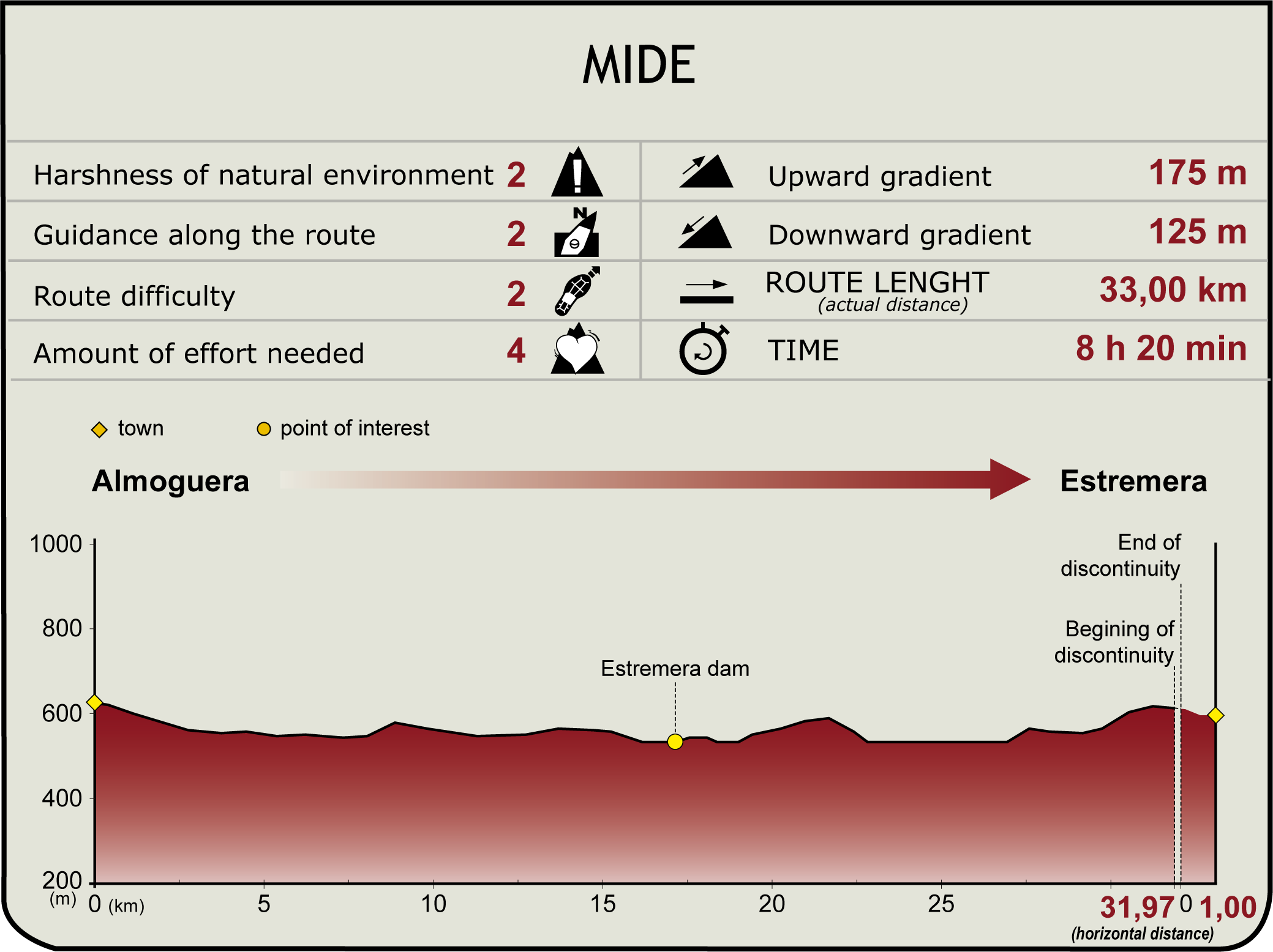
Stage 16: Almoguera - Estremera
Description
Walking through fields of grain and corn
This Stage between Almoguera and Estremera traverses through an agricultural landscape dominated by alternating fields of cereal (yellow) and corn (green).
This Stage begins in the town of Almoguera (please refer to Stage 15 for further information). The Trail leaves the ruins atop the town to the left, and continues along a mostly straight track towards the River Tagus. The silhouette of the Church of Christ, strategically located on high ground between the river and the town, can be seen from here.
The path runs into the River Tagus at the Almoguera Reservoir, which impounds and channels its waters a few hundred metres downstream to generate electricity. The stretch of the path shared with Stage 15 leads away from this area onto another path that is exclusive to Stage 16.
It first runs along the canal for about 700 m, then shifts to the left bank of the River Tagus, still on GU-249, passing next to an power plant, which generates electricity using the water channelled from the reservoir, and a fish farm located at the foot of the ruins of a castle, with a sign indicating the access road.
Leaving the fish farm behind, the Stage drifts onto an offshoot road to the right that steadily climbs away from the river, although the waterway remains visible throughout most of the journey. The farmland that the Trail will traverse can be seen from here. Depending on the season, it is possible to enjoy the beautiful contrast between the yellow and green fields that embellish the landscape. The Stage also runs through several intensive livestock farms. It should also be recalled that this part of the Stage traverses through the “Sierra de Altamira” Site of Community Importance (SCI) and Special Protection Area for Birds (SPA).
The Trail is dotted with water infrastructures, such as the old Estremera Dam, located high up the hill, which contrasts sharply with the modern version. The house of the Conde de la Cumbre Hermosa stands proud atop this hill, as well as a rest area with beautiful views of the reservoir.
From here, the traveller ventures into a spectacular landscape of a narrow gorge on the river. Metal handrails have been placed in the more exposed places, therefore, if you are cycling, it is advisable to get off the bike and walk, as some areas are quite narrow and winding.
Following the river along the left bank, the path reaches the interStage with GU-282, which will guide the traveller in the approach to and transit through the residential developments (Soto, Río Llano and San Joaquin) located on the outskirts of Illana, where one may visit the shrine equipped with a rest area and a playground.
The Trail now crosses the river to continue along its right bank until it reaches a bend where it first turns right, and then left, to continue along a road, through the gentle fields, that lead to the gates of Estremera.
From here, the town of Estremera is only a few kilometres away along the Nature Trail, which now ventures into the administrative border of the Autonomous Community of Madrid. Please be advised that the Reguero Brea, which the Trail crosses, may carry large volumes of water depending on the season. Several concrete blocks have been placed to make crossing easier.
Near the end of this Stage is an interStage with the M-222, which cuts off the Trail about 200 m before reaching Estremera. Having covered this distance (the use of a vehicle is recommended for safety reasons), the path leading to the destination reappears on the shoulder to the left.
Sites of interest
Profile

Highlights
Further information
Archaeological Site of Estremera
Evidence of human presence, dating back to prehistoric times, has been found in the Pedro Fernandez Cave, or "Sima de las Yeseras", within the municipal limits of Estremera. This natural cave system is riddled with about 4 km of horizontal galleries, and is home to a priceless archaeological site, in which excavations have been ongoing.
Archaeological studies have found (early and middle) Bronze Age remains dating from 1600 to 1200 B.C. The caves were not only used as a necropolis and a sanctuary, but also inhabited by the dwellers who lived interchangeably between the caves and the huts built along the riverbank, where they hunted, fished and gathered food. Indeed, they began to grow crops on the meadows, where their sheep and goats also grazed.
A number of archaeological remains can be found inside the Pedro Fernandez Cave, including "engravings" on the clay walls of some galleries, and several natural "shelves" with fragments or even whole pieces of pottery.
The cave was declared a Historical-Artistic Monument in 1972. However, the Government of Madrid closed the site a decade ago as a precautionary measure, and access is currently prohibited.


