Net of Natural
Trails

Stage 10: Trillo - Mantiel
Description
A walk with views
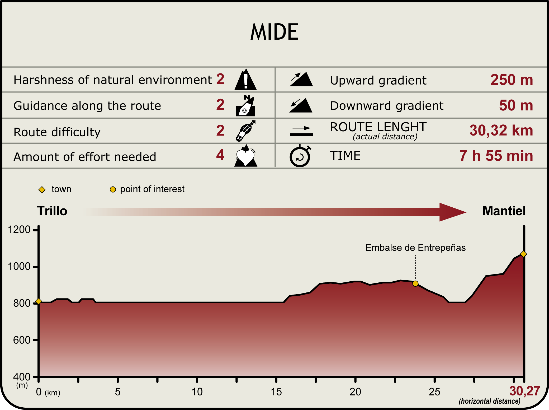
Stage 10 runs almost entirely through a wide forest track. This stretch of the Nature Trail is characterised by constant views of the river. The path winds between the meandering river and the tail of the Entrepeñas Reservoir, flanked by holm oaks and Portuguese oaks.
This Stage begins next to Trillo's stone bridge, along the road shared with the Meandros del Tajo Local Path. The Trail turns left and begins to climb at the sports centre, leaving to the right the paddle tennis courts and a pool.
Further 500 m down the road, the path reaches the Ermita Dam that feeds water to Trillo nuclear plant. The vehicle track located next to the weir is the road to Vivero, along which the Trail continues.
The path ventures into a young pine forest whose trees provide shade for several kilometres. The Trail runs along the left bank of the River Tagus, veering closer or farther from the river with each bend. Virtually since the beginning, this Stage of the Trail traverses through the Alto Tajo Site of Community Importance (SCI) and Special Protection Area for Birds (SPA).
The river gradually widens. When the water level drops, many birds can easily feast on the exposed banks. Large populations of fish, including carp (Cyprinus carpio) and barbel (Barbus bocagei), feed on organic debris and seaweed. The presence of many freshwater invertebrates attracts waterfowl. Some remain indefinitely, while others only stop temporarily to rest during their migration.
Great Crested Grebes (Podiceps cristatus), Cormorants(Phalacrocorax carbo) and Herons (Ardea cinerea) eat what they catch; Red (Milvus milvus) and Black Kites (Milvus migrans) scavenge dead or dying fish; and various ducks feed on plants and invertebrates. The waders, as its name indicates, find food in the mud and silt that form the banks. Other bird species, including Curlew(Numenius arquata), Common Redshank (Tringa totanus), Common Sandpiper (Actitis hypoleucos) and Pied Avocets (Recurvirostra avosetta) can also be seen frequently on the banks of the Tagus.
The trail reaches a junction with an information panel describing the species inhabiting these cliffs. The path continues to run near the river until it begins to climb, leaving it behind. From here, the end of this Stage is twelve kilometres away. After a few bends without a view of the river, it reappears as a huge meander close to the Entrepeñas Reservoir.
The Trail continues downwards to the CM-2053 road, where it turns left and then right, onto the road to Cereceda. After a few more bends, the signs indicate that the path leaves the paved road to venture upwards towards La Morucha along a track surrounded by olive trees. Although the slope is very steep, it is not difficult to climb. In just three kilometres, the trail reaches the village of Mantiel where this Stage ends. This Stage is frequently used by the inhabitants of Trillo.
Sites of interest
Puntos de interés
Culture
- Ermita de la Soledad
- Ermita de San Roque
- Ermita de la Virgen de Montealejo
- Iglesia de Nuestra Señora de la Asunción
Hydrography
Infrastructure
Municipality
Hostel
Profile

Highlights
Further information
Life in the grasslands
If there is ever an animal that is perfectly adapted to this habitat of pastures and scotch brooms, it is the rabbit (Oryctolagus cuniculus). Hidden among the brooms (Cytisus sp.) it only takes to the open space to feed on herbaceous plants, an opportunity that Golden Eagles (Aquila chrysaetos) and Bonelli's Eagles (Hieraaetus fasciatus), overflying the open plains, take advantage of to dive down out of the sky to pluck their daily meal.
Cows are also perfectly adapted to this environment, provided they have a watering place. Although the most common breed of cattle in the region is "Morucha", the "Sayaguesa" breed, originally from the region of Sayago (Zamora), can also be frequently found. The latter was used as a working animal for its hardiness and adaptability to changing conditions; however, the mechanisation of farm work led to their decline, and they are now bred for meat, widely appreciated by consumers.
Tetas de Viana
The Tetas de Viana Natural Monument is located between Trillo and Viana de Mondéjar, although it is acknowledged as a reference point across the district. They are two limestone wheels against a clay background, eroded by flash floods caused by the rivers.
This type of hill formation can be found in many places, but what makes the Tetas de Viana special is that two wheels, with similar dimensions, are aligned in twin formation.


