Net of Natural
Trails

Stage 9: Villaverde y Pasaconsol - Valverde de Júcar
Description
Arrival at the Alarcón reservoir.
This stage marks the meeting of the Júcar Nature Trail with an element of the landscape that will be a constant feature for much of the route: the Alarcón reservoir. Apart from its use for irrigation supply and energy generation, this body of water has become the habitat of numerous species of aquatic birds and a tourist destination for its beaches and water sports.
WARNING: Much of this stage may be flooded depending on the water level of the Alarcón reservoir. It is advisable to check the conditions of the road before setting off.

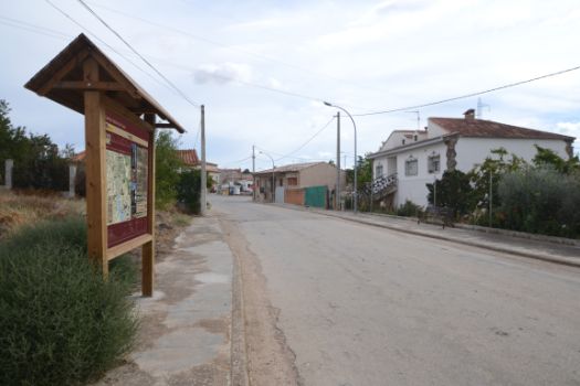
This stage begins on the outskirts of Villaverde y Pasaconsol, at the junction of Calle Fuente del Caño and Calle Boleo. It is via the latter we leave the town in a westerly direction. This street, which soon becomes a road, is one of the entrances to Villaverde y Pasaconsol from the CM-2103, so it is important to take care, especially in the 500 m where the pavements end, and trail follows the hard shoulder. The route then turns left next to an olive grove and, after about 200 m, reaches the CM-2103, which must be crossed with due caution.

On the other side of the road, the route enters a landscape of cereal crops and pastures, with some trees such as almond and olive trees. The main protagonist of this stage (and of a good part of the next two), the Alarcón reservoir, also comes into view on the right-hand side. Throughout the route along the reservoir, it is not unusual to find numerous aquatic birds on the banks or in the water: flamingos, coots, perch, avocets, egrets and various ducks.

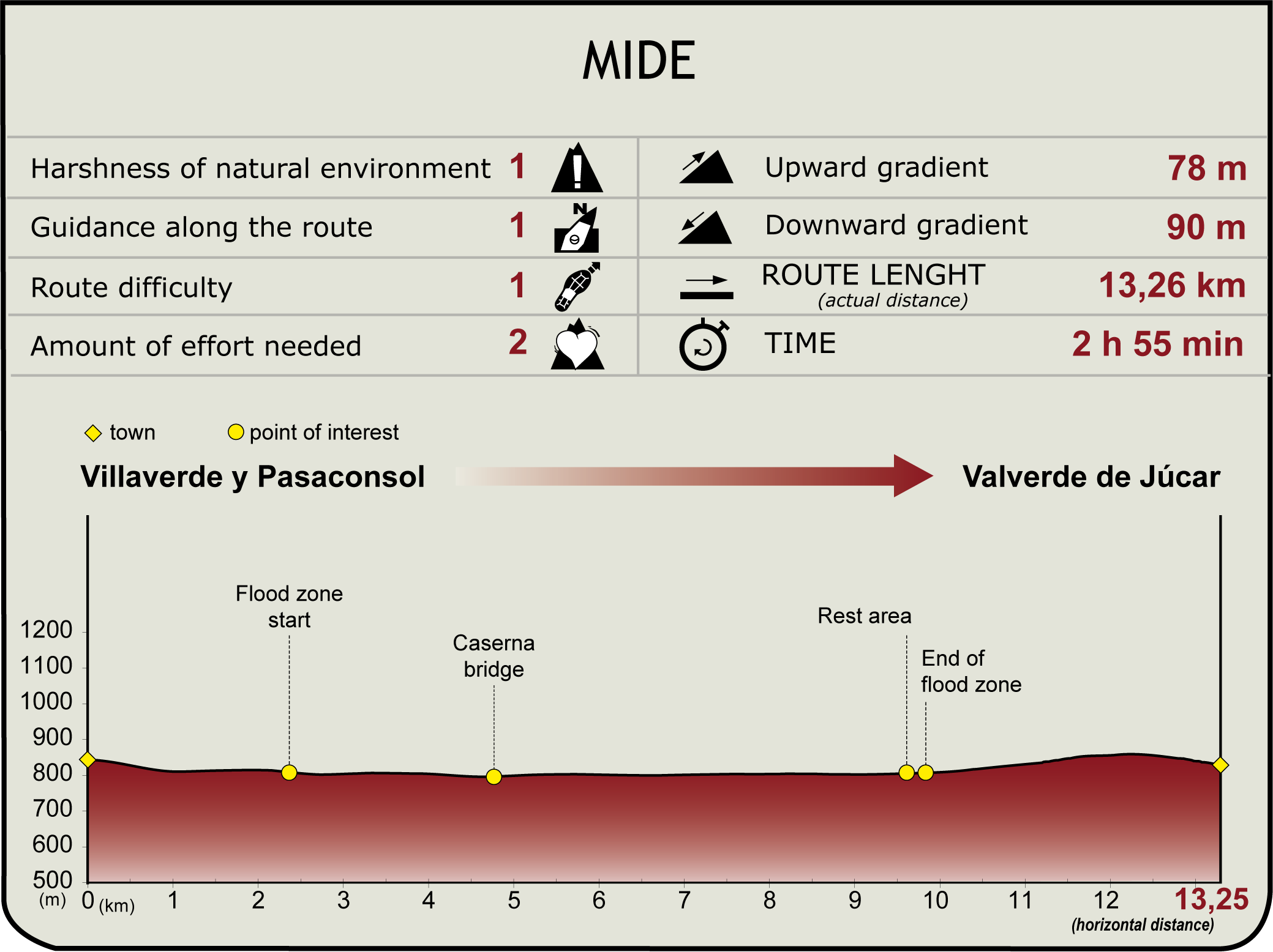
Once you reach the reservoir, the path heads south along the water's edge, between the flood zone on the right and the fields on the left. In just over 2 km, the dirt track that we had been driving on crosses a tarmac road, as it is an old road that used to connect Valverde de Júcar with Olivares de Júcar, which was flooded when the reservoir was filled.
When the waters are low, it is still possible to see the bridge of La Caserna, which was used to cross over the river Júcar when the road was in full use.

The asphalt is soon abandoned to return to the dirt track. To the right of the path there are different beaches, some with jetties, such as the beach of El Árbol or Mauri, while to the left there is a patch of pine forest that breaks the monotony of the cultivated fields. In just one of pine groves, one kilometre before reaching one of the most popular beaches in the area, that of Manchamar, the path changes direction towards the northeast, in search of Valverde de Júcar. The shade provided by this pine forest has been used to install a rest area.
The route heads slightly uphill towards Valverde, through an agricultural environment in which there are still some pine trees and small patches of Mediterranean scrubland. The proximity of the population is beginning to be felt with the increase in the number of olive groves. Before reaching Valverde de Júcar you can see, on a hill on the right hand side, an optical telegraph tower that belonged to the same line that will be found in stage 11 and a detour next to the first houses of the village allows you to follow the PR-CU-70 path. The stage ends shortly after entering Valverde de Júcar, on Avenida Madrid Valencia.
Enlaces de interés
Puntos de interés
Culture
Hydrography
Information
Infrastructure
Municipality
Hostel
Profile

MIDE (Method for the Information of Excursions)
Highlights
Further information
Embalse de Alarcón
This infrastructure covers an area of 6,840 hectares and has a capacity of 1,112 hm3. In the early 1930s, at the request of Valencian irrigators, the project began to be considered with the aim of regulating the waters of the River Júcar and facilitating the use of the waters for irrigation. It was in 1931 when the engineer Fausto Elio drew up the first preliminary project.
Construction began with the Second Republic, around 1937, but was halted with the outbreak of the Civil War, not officially restarting until 1942, when a joint initiative made up of more than 50,000 Valencian irrigators founded the Unidad Sindical de Usuarios del Júcar (USUJ), a union representing users of the river, which was responsible for financing the project.
The inauguration of the dam took place in 1955, but it was not until 1970 that the works were completed. This required a modification of the landscape, ecosystems and communication routes, conditioning the development and life of the riverside villages, whose economy, based on agriculture, evolved to other activities oriented towards tourism.
One of the consequences of the construction of the reservoir was the disappearance, in the 1950s, of the village of Gascas de Alarcón under its waters. A town now submerged, which was founded during the period of repopulation of the province of Cuenca, during the reign of Henry VIII, and whose ruins, walls and streets can be seen in times of drought, when the water level drops.
Mention information on another current function of the reservoir in the Tagus-Segura aqueduct: In the Alarcón reservoir, the water from the aqueduct joins the water from the Júcar, acting as a regulator of water transfers in the middle section.
Nowadays, the reservoir also serves as a tourist attraction for the nearby towns, especially in the summer season, thanks to the creation and accommodation of various inland beaches, including Playa del Árbol, Playa Olivares, Playa Mauri-Alarcón, Playa Emocio-Alarcón and Playa de Manchamar.
It has also become a perfect spot for sport fishing. There are endemic Iberian species in the waters, such as the barbel (Luciobarbus bocagei), and other species much sought after by fishers, although catalogued as invasive exotic species, such as carp (Cyprinus carpio), pike (Esox lucius), pikeperch (Sander lucioperca), black bass or American perch (Micropterus salmoides).
The area's ecosystem is ideal for wintering birds fleeing the cold of northern and central Europe. These include lapwings, herons and cranes.
Optical telegraphy
Optical telegraphy is a rudimentary technology that began in 1684, when the British scientist Robert Hooke presented the first telegraph to the Royal Society. However, this system of long-distance communication was not consolidated until the 18th century, with France being the first country to develop a network of telegraph towers. A project that began in 1792 and which transmitted the first message or telegram two years later.
The standardised model of the optical telegraph during the 18th and 19th centuries was that developed by the Chappe brothers. This consisted of a mobile mechanism, generally made of wood or metal, located at the top of a tower visible from a great distance (minimum 6 kilometres) and through which messages were transmitted using a code system that provided for 98 combinations.
The optical telegraph arrived in Spain in 1799, when the installation of the first towers began. This one, in particular, belongs to the Cuenca section of the Madrid-La Junquera telegraph line, which crossed Valencia, and was built in 1848.
Multimedia
Downloads
GPS Downloads
Documents
Cyclability
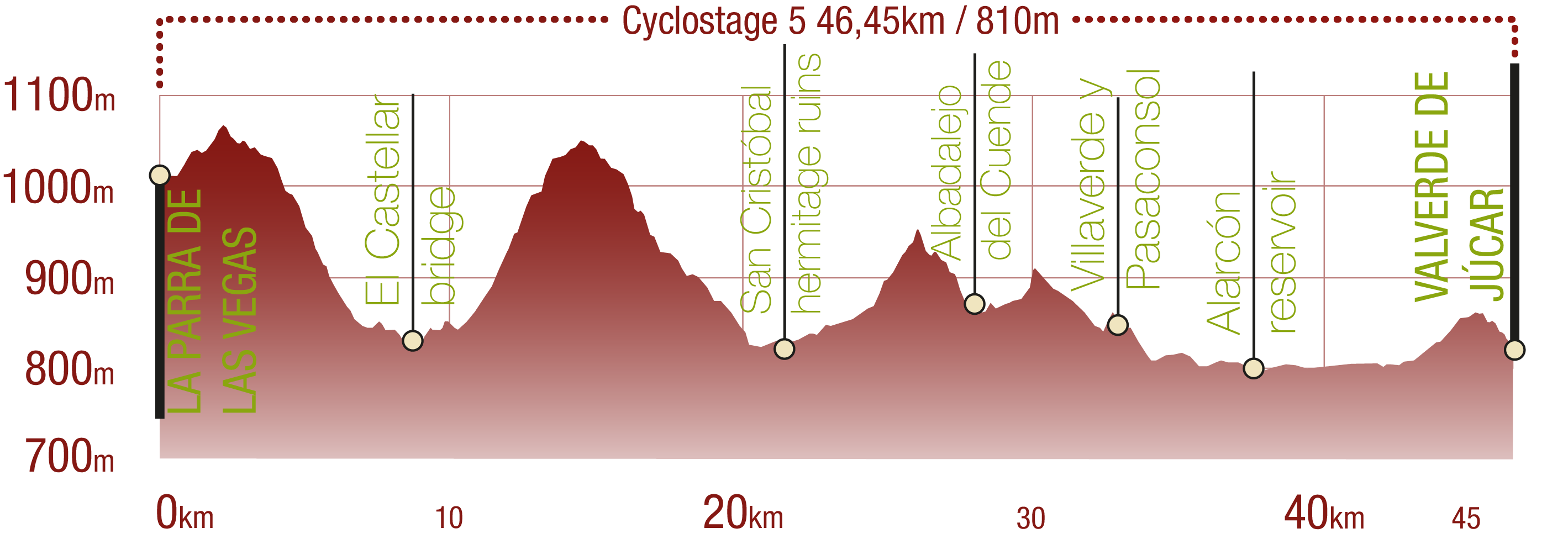
CYCLABILITY
This Cyclostage corresponds to stage 8, stage 8 branch (back forth) and stage 9 of the Nature Trail
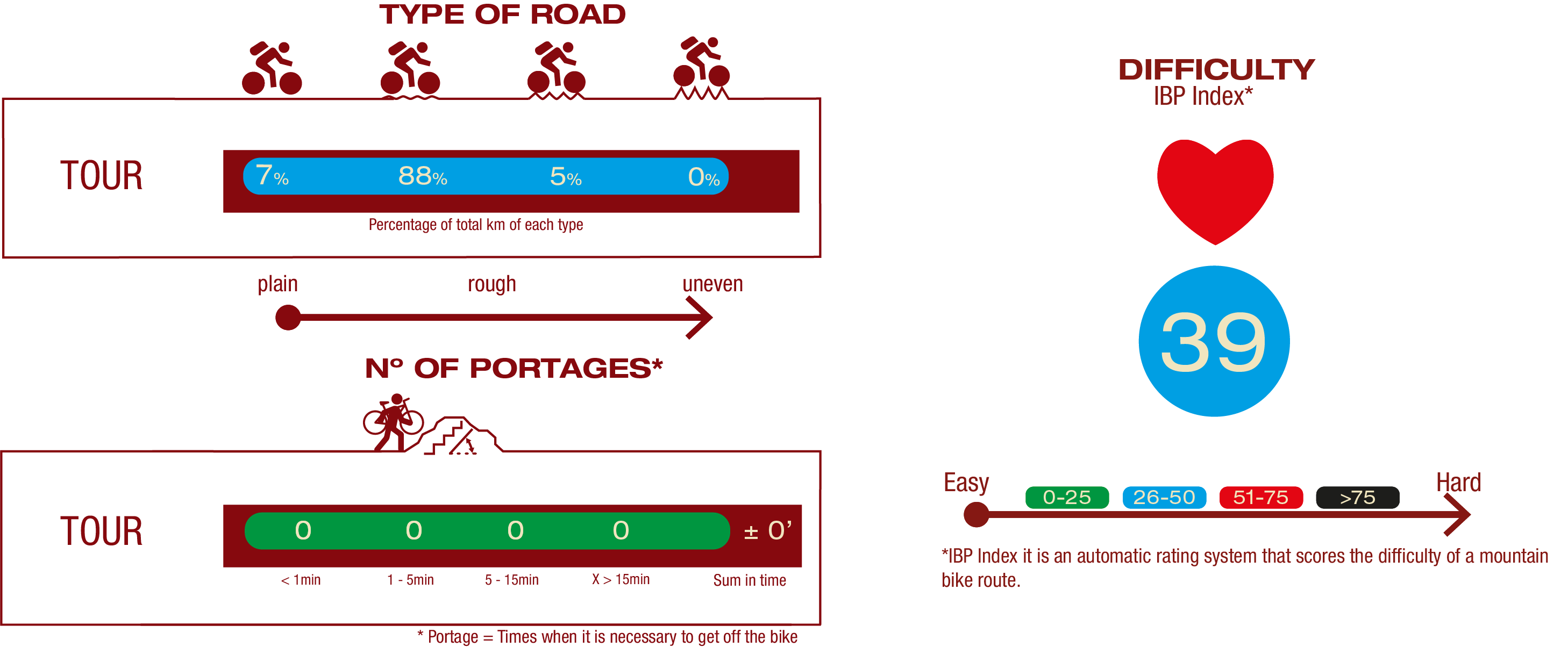
TYPE OF ROADS, PORTAGES & DIFFICULTY
SAFETY RECOMMENDATIONS
- The roads are mainly on tracks with access to farms and rural establishments, so there is a certain risk of being run over.
- Caution at road crossings and access to towns.
- Part of the route along the Alarcón reservoir may be flooded when the waters rise sharply, so it is advisable to check the state of the reservoir in advance.
GENERAL RECOMMENDATIONS
- Find out about the technical aspects of the route and the weather on the day.
- Take care of the environment. Take care not to disturb animals or damage vegetation. Respect private areas.
- You must give priority to pedestrians and comply with general traffic rules.
- The environment in which you will be riding is open, free to move around and an area where many activities are carried out (sporting, forestry, livestock and agricultural activities). Always have an understanding, prudent, responsible and respectful attitude.


