Net of Natural
Trails

Stage 8: La Parra de las Vegas - Villaverde y Pasaconsol
Description
Between pine forests and crops
This stage is a good example of the marked difference in landscape between the flatter areas, almost completely covered by crops, and the pine-covered slopes of the more rugged areas. The nature trail returns to the river that gives it its name after having left the company of the riverbed during the previous stage.

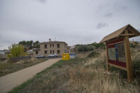
The eighth stage of the Júcar Nature Trail begins just at the entrance to La Parra de las Vegas, with its back to the San Roque shrine, next to the one we passed in the previous stage. You pass through this small village, passing the church of La Asunción, the town hall and the ruins of the palace of the Counts of Cervera, and leave the town centre on one of its outer streets, where you come out onto the CUV-7131 road. The next half kilometre runs along this road, and caution should be exercised during transit.
The route begins with a gentle but continuous ascent, passing the Cristo de la Salud shrine. Leave the road along a dirt track on the right and then the path enters a bushy area of genista and labiata where the ascent practically ends at a crossroads. The path on the right leads to the bridge of El Castellar (see the stage 8 branch), although the route continues along the path on the left.

The path begins to descend and, as it continues to advance, the vegetation becomes more and more abundant, with a stratum of pine trees appearing in the company of some holm oaks. In terms of shrubs, it is now possible to find kermes oak (Quercus coccifera), heather (Erica spp.) and juniper (Juniperus phoenicea).
After about 2 km, the trail comes to a rural construction typical of the agricultural holdings in this area called tinadas, and after another kilometre, the mixed pine forest is interrupted more and more frequently by ploughed or cultivated land. After a steeper descent on a narrowing path, the road turns ninety degrees. The presence of the River Júcar is evident in the gallery forest that can be seen when looking southwards.

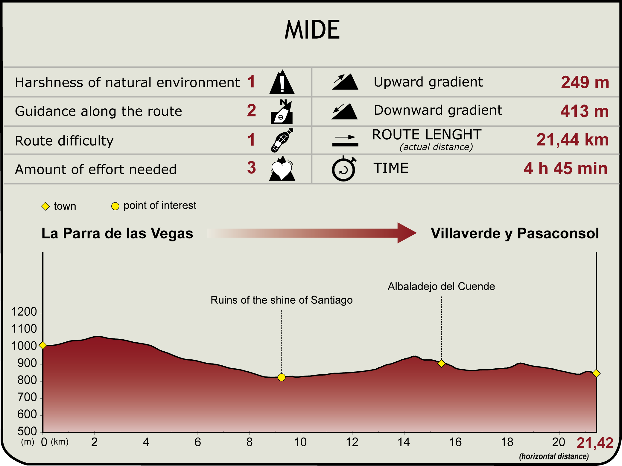
There is an almost negligible presence of trees for the next 7 km, the path enters a rolling landscape covered with cereal crops, fodder and some trees (almond, olive and pistachio trees). In one of these fields of crops you can see the remains of the shrine of Santiago. These ruins are the only surviving witness to a small village that belonged to Albaladejo del Cuende.
Albaladejo is accessed from the northwest, leaving a small hill to the south on which a shrine sits and the old church of Nuestra Señora de la Asunción, which overlooks the village from its elevated position, in front of it. Of this church, whose oldest origins lie in the construction of churches after the Christian conquest, only the tower and some of its walls remain standing.

Without entering Albaladejo del Cuende, the route heads south along a concrete road which, after leaving the last warehouses of the village behind, turns into a dirt track. The almost exclusively agricultural landscape is recovered, interrupted only by a patch of Mediterranean scrubland accompanied by holm oaks just a kilometre before reaching Villaverde y Pasaconsol. After passing by the cemetery, this village is accessed from the northeast, leaving the washhouse and watering place to one side.
It crosses Villaverde y Pasaconsol passing through the Plaza Mayor, where the church of Nuestra Señora de la Purificación is located, and the stage ends almost at the exit of the village, at the junction of the Calle Fuente del Caño and Calle Boleo.
Sites of interest
Puntos de interés
Culture
- Ruinas de la ermita de Santiago
- Antigua iglesia de Santa María de la Asunción
- Ermita del Cristo de la Salud
- Ermita de San Isidro
- Ermita Virgen de las Nieves
- Lavadero de Villaverde y Pasaconsol
Infrastructure
Municipality
Hostel
Vegetation
Profile

MIDE (Method for the Information of Excursions)
Highlights
Further information
Albaladejo del Cuende
The municipality of Albaladejo del Cuende takes its name from the Arabic word al-balant meaning “road” and the sobriquet del conde meaning “of the count”.
The history of this village is closely linked to the period of Christian reconquest and repopulation, which reached the present-day province of Cuenca during the reign of Alfonso VII (12th-13th centuries).
In 1080, these territories were ceded to the Cistercian monks of the monastery of Santa María de Huerta, in Soria. A transfer that demonstrates the importance of this urban centre at the time.
The urban plan of this municipality is articulated around an ancient church, the Church of Santa María de la Asunción, located on the top of a hill and which is currently being restored in an attempt to preserve the walls and the tower that are still standing. This building dates from the 16th century and was erected on the remains of an old Romanesque church designed after the conquest of Alfonso VIII. Today, only the tower and some of the walls that once formed part of the main building remain of the church.
Albaladejo del Cuende is a mainly agricultural and livestock farming village where you can't miss the shrine of las Nieves, built in the 17th century, with its beautiful carved stone façade and its hall shape, the aforementioned Church of Santa María de la Asunción, the shrine San Isidro and the ruins of the shrine of Santiago. The town celebrates local festivals on 5 August, paying homage to the patron, the Virgen de Las Nieves. These festivals bring together neighbours, families and visitors for bullfighting festivals, several open-air parties and the procession and mass in honour of the aforementioned virgin.
Roman City of Valeria
About 7 km east of Albaladejo del Cuende lies the Roman city of Valeria. Founded in 90 BC by Gaius Valerius Flaccus, Valeria is nestled between the gorges of the rivers Gritos and Zahorra, which form a spectacular landscape and endow the city with imposing natural walls.
The city has preserved the forum and the public square, next to which buildings such as the basilica and the curia were erected. Underneath the square are four water cisterns that supplied the town and a monumental nymphaeum of almost 100 metres in length. The site is completed by the remains of the medieval walls and the shrine of Santa Catalina in the upper part. The latest excavations have uncovered the city's thermal baths.
The church of La Sey was built in the present-day centre of Valeria. It was the Episcopal See during the Visigoth period and was erected over a pre-Roman sanctuary dedicated to the pre-Roman god of Hispania, Airón. Materials from the Roman city, such as columns and inscriptions, were reused in its construction.
Villaverde y Pasaconsol
Villaverde y Pasaconsol is a municipality in Cuenca, some 50 kilometres from the capital. For centuries it belonged to the cathedral chapter of Cuenca, until the confiscation of Madoz (19th-20th century).
The village was formerly two independent localities, until the 19th century, when Villaverde absorbed the then small hamlet of Pasaconsol.
The latter gets its name from a popular legend passed down from generation to generation about the dangers of crossing the river Júcar at night, the legend of the Ninfa of the Júcar. A traditional story in which the phrase pasa con sol or “go with sun” is repeated several times, which will end up giving its name to this municipality.
As for the meaning of Villaverde, its name comes from "Villar Verde", Villar, because the village is located on the site of an ancient late Roman villa, and verde meaning green because of the fertility of the surrounding land. For this reason, Villaverde y Pasaconsol is a mainly agricultural village, focused on the cultivation of olive trees, vines, sunflowers and almond trees.
Within its architecture, the most outstanding feature is the landscaped main square where the Parish Church of Nuestra Señora de la Purificación is located. With its rectangular-shaped hall floor plan, inside which you can still see a Baroque altarpiece with a niche and the Crucifixion Tablet, dating from the 14th and 15th centuries, which belongs to the Castilian school.
It is also interesting to visit two of the hydraulic constructions that supply water to the municipality, the Villaverde y Pasaconsol, an old washhouse and the Huerta Vieja reservoir, both fully functional structures. Local festivals in honour of San Marcos are celebrated on 25 April and San Isidro on 15 May.
But the biggest festival is undoubtedly the Candelaria, which is celebrated on 2 February, the day on which the inhabitants of the municipality make, according to the tradition inherited from the Arabs, a 250-kilo alaju cake. This is a traditional sweet typical of the province of Cuenca made from a dough of almonds, breadcrumbs, spices and honey. The name comes from the Arabic al-hasú, which means stuffing.
Multimedia
Downloads
GPS Downloads
Documents
Cyclability
CYCLABILITY
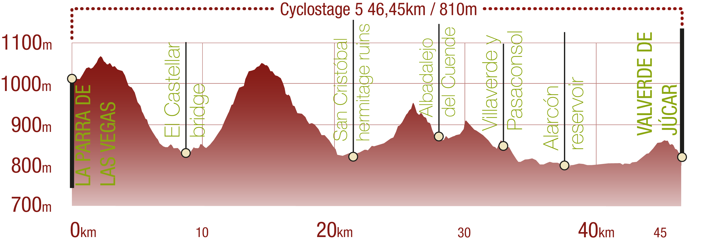
This Cyclostage corresponds to stage 8, stage 8 branch (back forth) and stage 9 of the Nature Trail
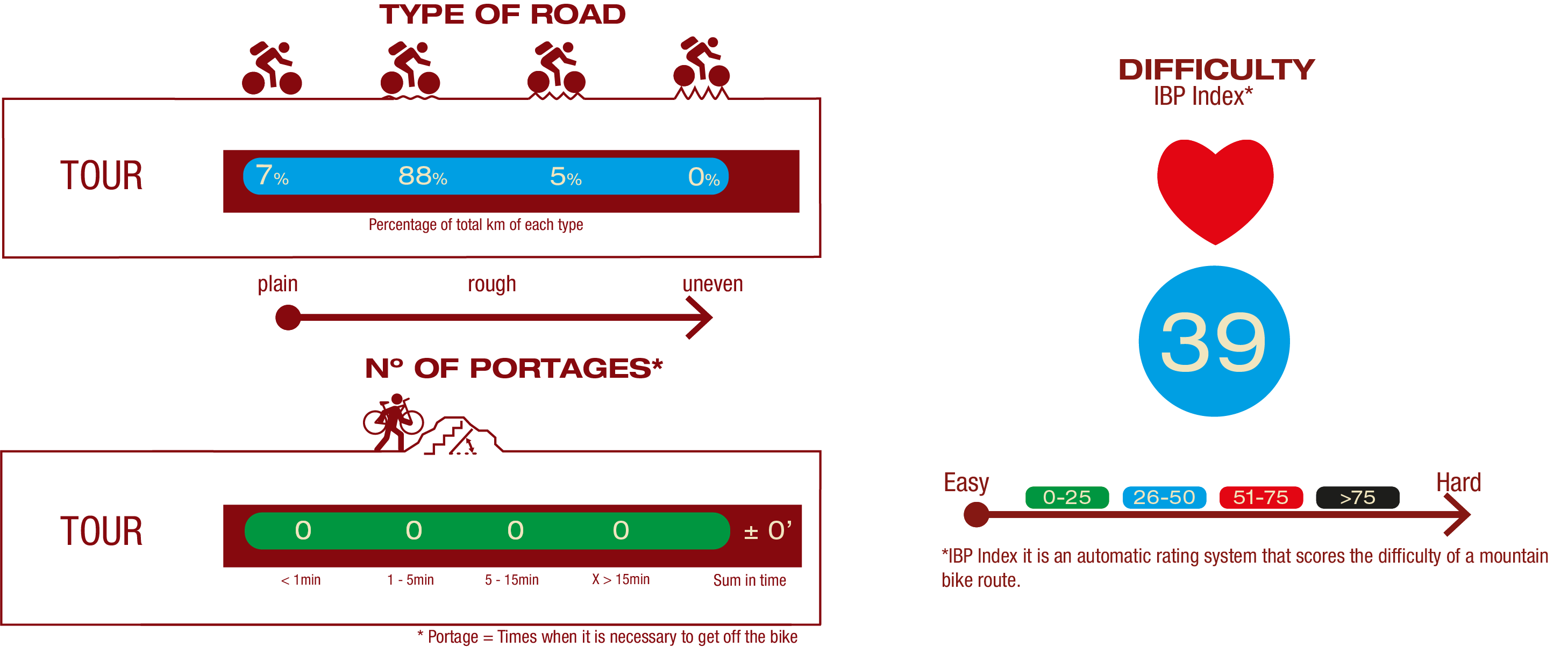
TYPE OF ROADS, PORTAGES & DIFFICULTY
SAFETY RECOMMENDATIONS
- The roads are mainly on tracks with access to farms and rural establishments, so there is a certain risk of being run over.
- Caution at road crossings and access to towns.
- Part of the route along the Alarcón reservoir may be flooded when the waters rise sharply, so it is advisable to check the state of the reservoir in advance.
GENERAL RECOMMENDATIONS
- Find out about the technical aspects of the route and the weather on the day.
- Take care of the environment. Take care not to disturb animals or damage vegetation. Respect private areas.
- You must give priority to pedestrians and comply with general traffic rules.
- The environment in which you will be riding is open, free to move around and an area where many activities are carried out (sporting, forestry, livestock and agricultural activities). Always have an understanding, prudent, responsible and respectful attitude.


