Net of Natural
Trails

Stage 4: Uña – Villalba de la Sierra
Description
A magical journey through the spectacular Ciudad Encantada rock formation
This stage of the trail, at just over 14 kilometres long, conceals and connects some spectacular scenery, such as the viewpoints of Uña and Villalba de la Sierra, at the start and end of the stage respectively. Much of the route goes through the Serranía de Cuenca Natural Park and the iconic Ciudad Encantada, or Enchanted City, discovering its most unknown and solitary formations.

The fourth stage of the Júcar Nature Trail begins next to the interpretative panel at the car park in the town of Uña. A wonderful starting point located in an impressive natural setting formed by the Uña lagoon and the typical cliffs of the Serranía de Cuenca Natural Park.
As we embark on the stage we say farewell to the picturesque town of Cuenca, heading towards the capital along the CM-2105 road. First, we walk along a pavement before continuing on the hard shoulder, so extreme caution is recommended. After crossing the river Júcar, we cross the road and leave it for good, taking an asphalt track. Before continuing along the route, it is well worth taking a brief detour to follow the signs to visit the Uña travertine, a geological formation of great interest and beauty.

Further on, the trail begins to climb uphill. We pass a recycling bring centre and Uña cemetery on the left, at which point it becomes a dirt track. We then enter a coniferous forest, mainly made up of Scots pine (Pinus sylvestris) and black pine (Pinus nigra), which is becoming more and more evident. As the forest becomes more and more dense, it offers the traveller some pleasant shade.
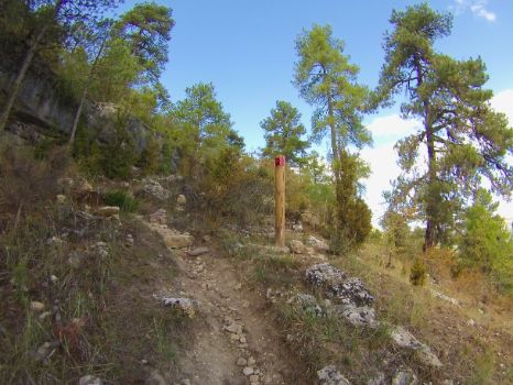
We then reach a perfectly signposted crossing, taking the left. Shortly thereafter there is a sign indicating the beginning of a section on foot, just as the steep slope that will dominate this section begins.

From this point on, travellers will need a firm and determined attitude as they tackle this stretch of just over 1.5 kilometres that will test their physical fitness while at the same time delighting those who love the mountain scenery. This section runs entirely along a path that zigzags uphill to avoid the steeper slopes.
After the effort of the climb, we are rewarded upon reaching the Mirador de Uña viewpoint, the perfect place for some respite and to regain strength while taking in the panoramic views of the upper course of the Júcar, the Serranía de Cuenca and the town of Uña, a picture postcard panorama. Explanatory tables inform the traveller of the most outstanding geographical features and of the rest of the natural values of this magical spot.

After that short break, we continue our journey along the dirt track from the viewpoint. The route then reaches kilometre 4 of the stage and, shortly afterwards, the fire extinguishing tower, where a short cross-country section begins. The route continues following the Caminos Naturales signposts before crossing the CM-2104 road, taking all necessary precautions, to continue along the dirt track.
We soon reach kilometre marker 5, confirming we're on the correct route. Almost without realising, the traveller is immersed in the spectacular Ciudad Encantada rock formations. Even if the trail won’t take us to the most famous geological formations, this opportunity to discover the less explored corners of this beautiful spot should not be passed up. Enjoy the flora and fauna that quieter travellers can observing in peace and quiet.
There is a succession of changes in the surface of the trail from path to cross country, as we follow the official Caminos Naturales signage. Where possible, we recommended using a mobile device with the official route on the Caminos Naturales website (https://www.mapa.gob.es/en/desarrollo-rural/temas/caminos-naturales/caminos-naturales/sector-centro/jucar/default.aspx).
After passing kilometre 7 of the stage, the most curious rock formations of the Ciudad Encantada come into view. Calmly chiselled by the passage of time, they offer an invitation to the traveller to stop and play at imagining, together with his fellow travellers, what these formations might resemble. Shortly after passing kilometre point 8, turn left at the crossroads and, before another kilometre marker, take the path to the left at a fork in the road, which continues along the crest, enjoying spectacular views of the mountain scenery.

The route gains metres in altitude as it climbs to the Mirador de Villalba de la Sierra viewpoint. A spectacular spot where you can look back and enjoy what you have done and what lies ahead. Before continuing, this place is worthy of a brief stop. You can take some time to regain your strength on the specially placed bench and learn more about the species of ungulates that inhabit the Serranía de Cuenca Natural Park thanks to a panel located next to the bench.
After this well-deserved break for body and soul, the descent begins, which is firstly along a path and then metres later takes the dirt track on the left, all duly signposted. The rapid and comfortable descent zigzags down the slope as the dense pine forest, predominant throughout the stage, gives way to a holm oak forest with a rich undergrowth populated by the species typical of Mediterranean scrubland.

The end of the descent is marked by an interpretative panel offering information about the nearby Salto de Villalba, also well worth a visit, as is the nearby Ventano del Diablo. At this point, the holm oak grove also disappears, and the land is occupied by agricultural crops in the nearby fertile lowlands of the River Júcar.
The journey continues, turning left and continuing parallel to the CM-2105 road until it crosses it. On the other side, there is a bridge over the river Júcar and an interpretative panel indicating the end of the fourth stage of the Júcar Nature Trail, which welcomes you to the town of Villalba de la Sierra.
Sites of interest
Puntos de interés
Geology
Hydrography
Information
Infrastructure
Municipality
Hostel
Profile

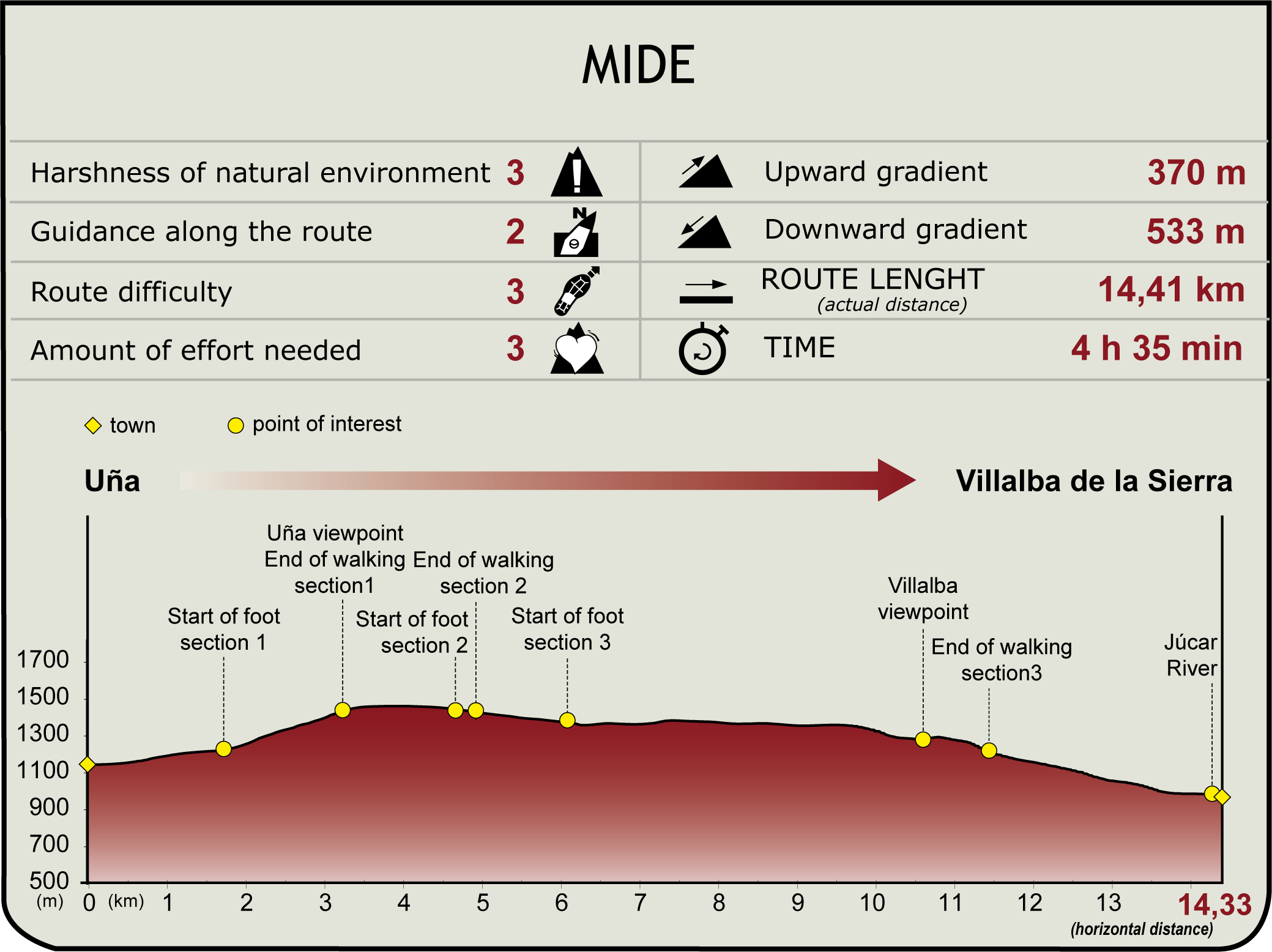
MIDE (Method for the Information of Excursions)
Highlights
Further information
Uña
Uña is a picturesque town in the province of Cuenca, located in the heart of the Serranía de Cuenca Natural Park that was repopulated in the 13th century by Aragonese and Castilian settlers after the conquest of Cuenca.
Outstanding among its architectural heritage is the church of San Miguel Arcángel, dating from the 13th century, as well as the town hall, located next to the church. Its inhabitants have traditionally been dedicated to agriculture, and nowadays the tourist sector is one of the main pillars of its economy, due to its abundance of natural heritage.
An example of this heritage is the Uña lagoon, which collects the waters of the fast-flowing Rincón stream. Over the years, the precipitation of calcium carbonate formed the Uña travertine, a natural tuff dam with a viewpoint for visitors to enjoy the spectacle.
Villalba de la Sierra
Localidad perteneciente a la mancomunidad de El Campichuelo-Serranía Media, muy cercana de la capital conquense, apenas 20 kilómetros. Sus orígenes se remontan a la Edad de Bronce, como así atestiguan restos encontrados en las cercanías del cerro del Lituero. Aunque probablemente el núcleo urbano actual estuvo habitado en diferentes épocas, su consolidación tal y como se le conoce hoy día se produjo tras la repoblación promovida por el rey Alfonso VIII.
Tradicionalmente dedicado a la agricultura, la ganadería y el aprovechamiento forestal, en la actualidad, debido a su ubicación privilegiada respecto al Parque Natural de la Serranía de Cuenca, el sector turístico está convirtiéndose en uno de los motores de su economía. Desde el punto de vista arquitectónico destaca la iglesia románica de Nuestra Señora de la Natividad, patrona del pueblo y en honor a ella se celebran sus fiestas a primeros de septiembre.
Sin duda alguna uno de los acontecimientos de mayor importancia en la localidad fue la inauguración en 1926 por el rey Alfonso XIII de la central hidroeléctrica de El Salto. Su construcción y puesta en funcionamiento duplico la población y acabo asentando demográficamente el municipio. El río Júcar siempre ha estado ligado a Villalba de la Sierra, formando bellos parajes como el Ventano del Diablo y su hoz con cortados que llegan a los 200 m de altura, salpicando el cauce de rápidos y remansos.
Multimedia
Downloads
GPS Downloads
Documents
Cyclability
CYCLABILITY
This Cyclostage corresponds to stage 4 and stage 5 branch of the Nature Trail
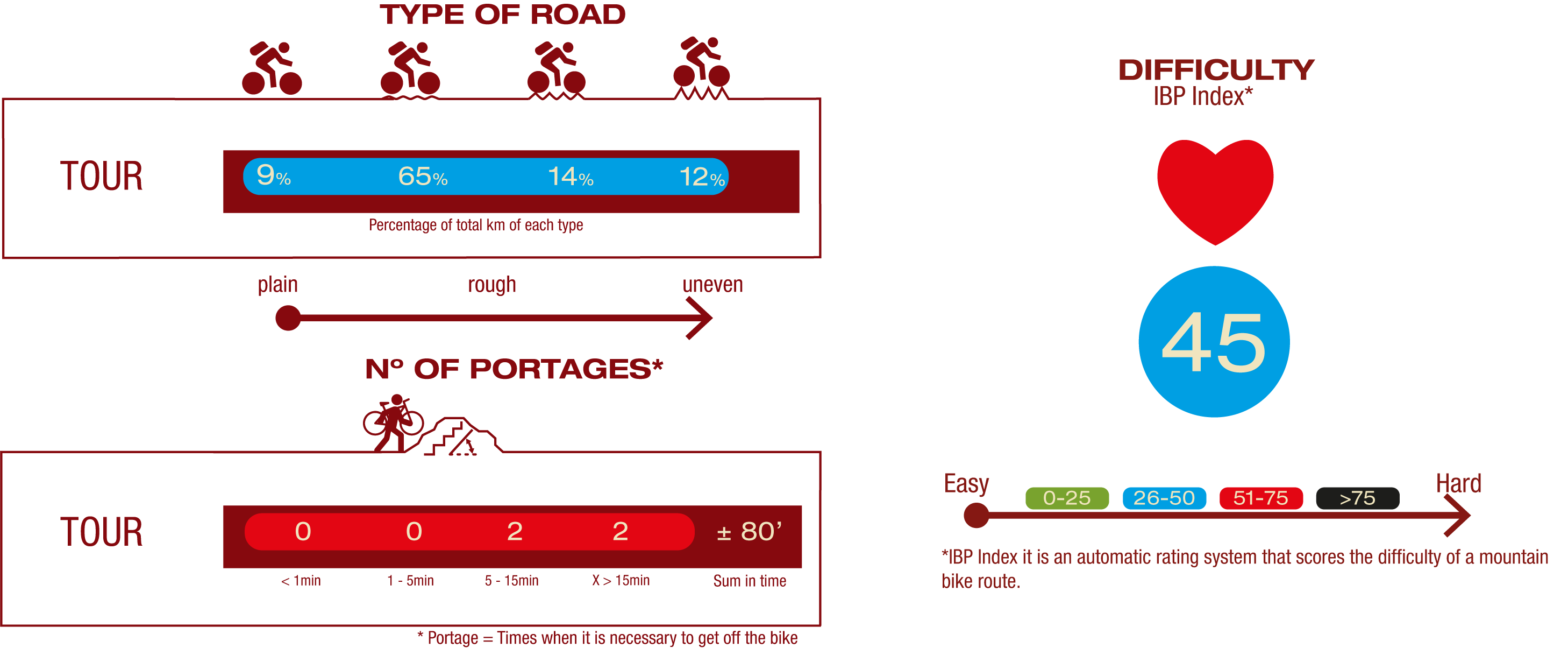
TYPE OF ROADS, PORTAGES & DIFFICULTY
SAFETY RECOMMENDATIONS
- Mountain bike trails with several stretches of footpaths of different lengths and difficulty.
- Extreme caution should be exercised and all information for cyclists should be read carefully, and the trip should be abandoned if in doubt. .
- There are walking section where cyclists must dismount, sections of path, sections with rocky outcrops, sections with loose stony ground, demanding ascents and long descents.
- They run through an area of great scenic value with the inherent risks of the Sierra de Cuenca.
GENERAL RECOMMENDATIONS
- Find out about the technical aspects of the route and the weather on the day.
- Take care of the environment. Take care not to disturb animals or damage vegetation. Respect private areas.
- You must give priority to pedestrians and comply with general traffic rules.
- The environment in which you will be riding is open, free to move around and an area where many activities are carried out (sporting, forestry, livestock and agricultural activities). Always have an understanding, prudent, responsible and respectful attitude.


