

Net of Nature
Trails

Stage 11: Buenache de Alarcón - Alarcón
Description
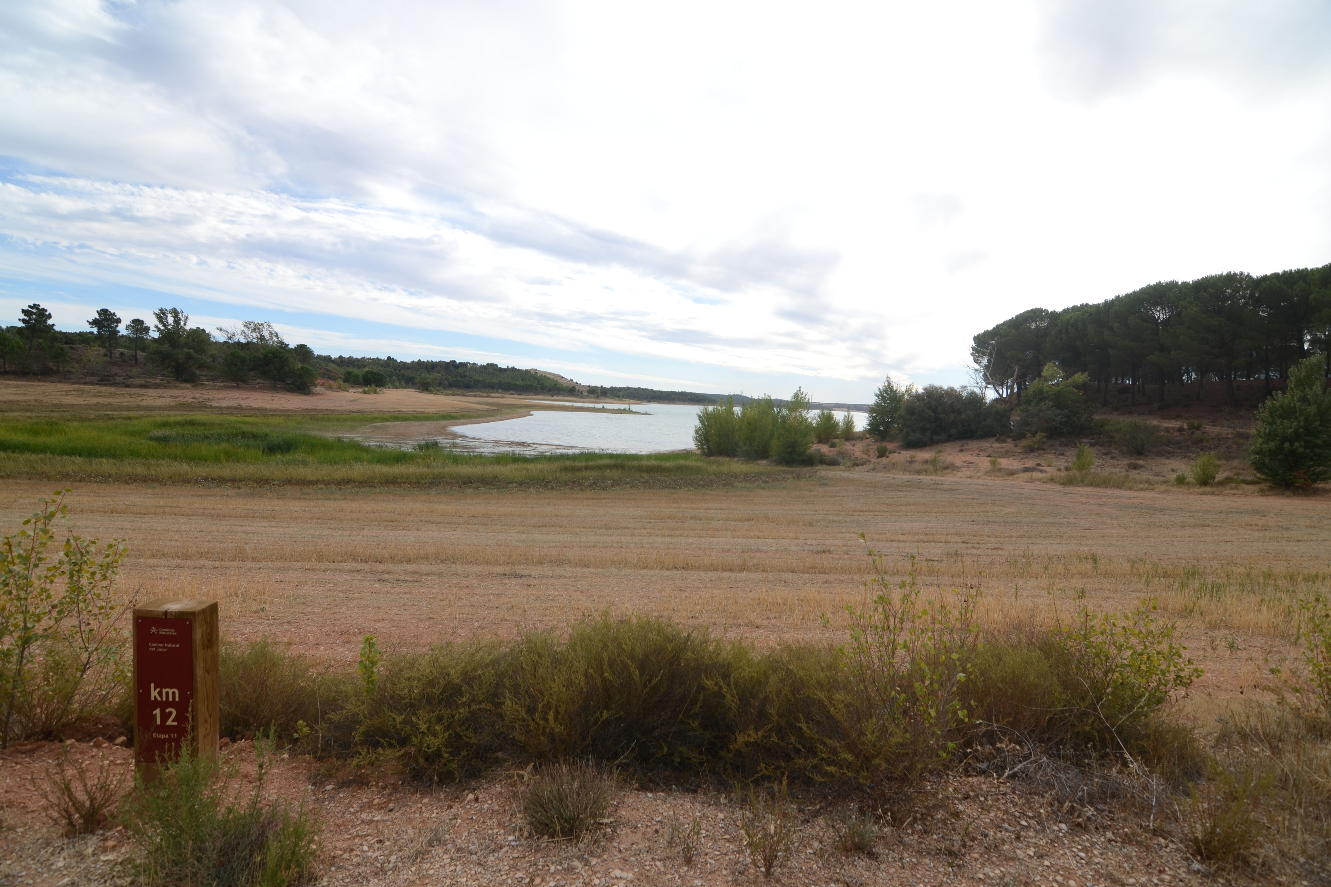
Skirting the Alarcón reservoir
On returning to the banks of the Alarcón reservoir, the Nature Trail runs along the banks of the reservoir through an essentially agricultural environment dotted with patches of Mediterranean scrub, holm oak and pine forests.

Starting from the centre of Buenache, the route starts off along Calle Isabel I de Castilla, heading west until it reaches the shrine of San Isidro, a simple church in the centre of the town. The route then turns south, reaching the CM-2100 road. You have to walk alongside the road for about 100 m and, although it is not particularly dangerous as it is a stretch of urban road with good verges and a zebra crossing, caution should be exercised.
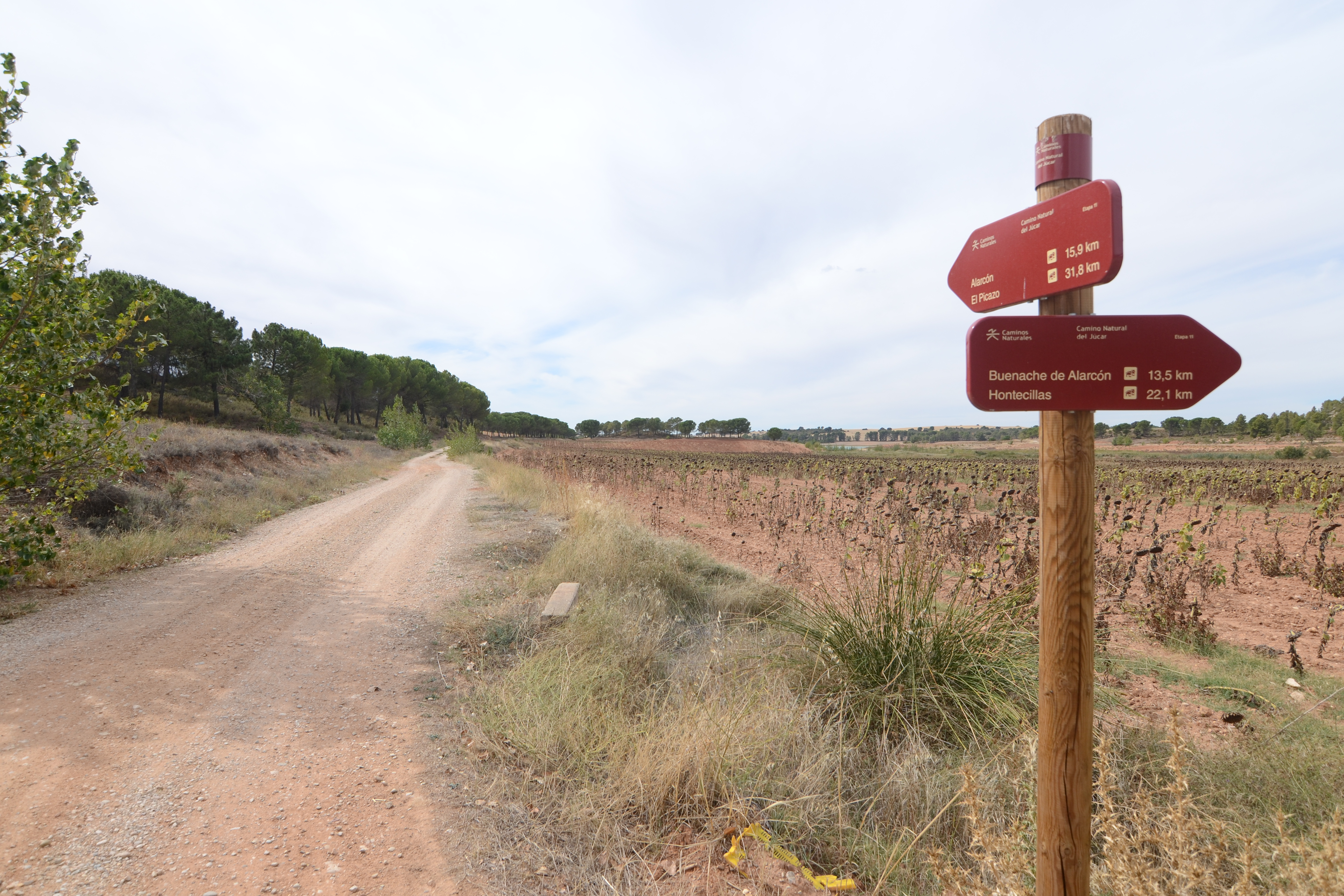
Leave the road along a dirt track on the right, heading south. The trail then enters an agricultural landscape of cereal crops, with some farms planted with fruit trees, for the next 2 km. When you reach a crossroads, continue along the path to the right towards the south, which, after passing by a small pine forest, returns to the cultivated landscape, although this time the trees, together with some vineyards, outnumber the cereals in terms of surface area.

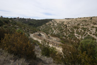
The route approaches the reservoir, without reaching the shore, although the sheet of water will almost always be visible when looking to the right of the path. You leave behind you various junctions with other minor tracks that should be avoided, until, after a little over 3 km, the path changes direction, heading north-east. In the distance, on one of the hills in the background, you can make out the tower of an optical telegraph that belonged to the same line as the one at Valverde de Júcar (Stage 9-10).
The trail reaches the CM-2100 road and runs parallel to it, on the left-hand side, for some 200 m, so remember the rules of the road! I then leaves the asphalt when it reaches the Cañada fountain. The route now heads in a southerly direction, following the banks of the reservoir. A sign warns us that this area may be flooded, so it is important to check the water levels before you start walking through it.
The path runs alongside the reservoir, with the water on our right-hand side and vegetation with pines and Mediterranean scrubland on our left. After approximately 3.5 km you reach a turn-off leading to Olmedilla de Alarcón, but the path continues alongside the reservoir. With the same type of landscape as in the previous section, after almost 4 km you reach, a very particular structure, a small stone semicircle with a column in the centre that was built in 2010 in memory of Gascas, a town that was flooded by the waters of the Alarcón reservoir.
The route leads away from the reservoir and returns to an almost exclusively agricultural landscape of surrounding farms. Leaving other different paths behind us, it finally leads to another dirt track. Olmedilla can be reached again on the left, although the path continues on the right. After passing by a solar farm, the path climbs slightly and enters a wooded area. This landscape will last no longer than a kilometre and a half or so before we see the Alarcón reservoir dam among the trees.
Returning to the agricultural landscape, you walk through farmland, past some rural accommodation buildings and reach a paved walkway through pine trees, leading to the N-III road. Cross the road carefully as despite good visibility, vehicles may speed. On the other side of the N-III, take a dirt track that leads to the road that runs towards Alarcón. Before reaching the road, the path turns off to the right onto a footpath that descends, protected by wooden fences, down a ravine to reach the canyon of the river Júcar. The descent leaves beautiful panoramic views of the monumental Villa de Alarcón and the Torre de los Alarconcillos and when you reach the river you can take advantage of the wooden benches installed to take a break and enjoy the view.

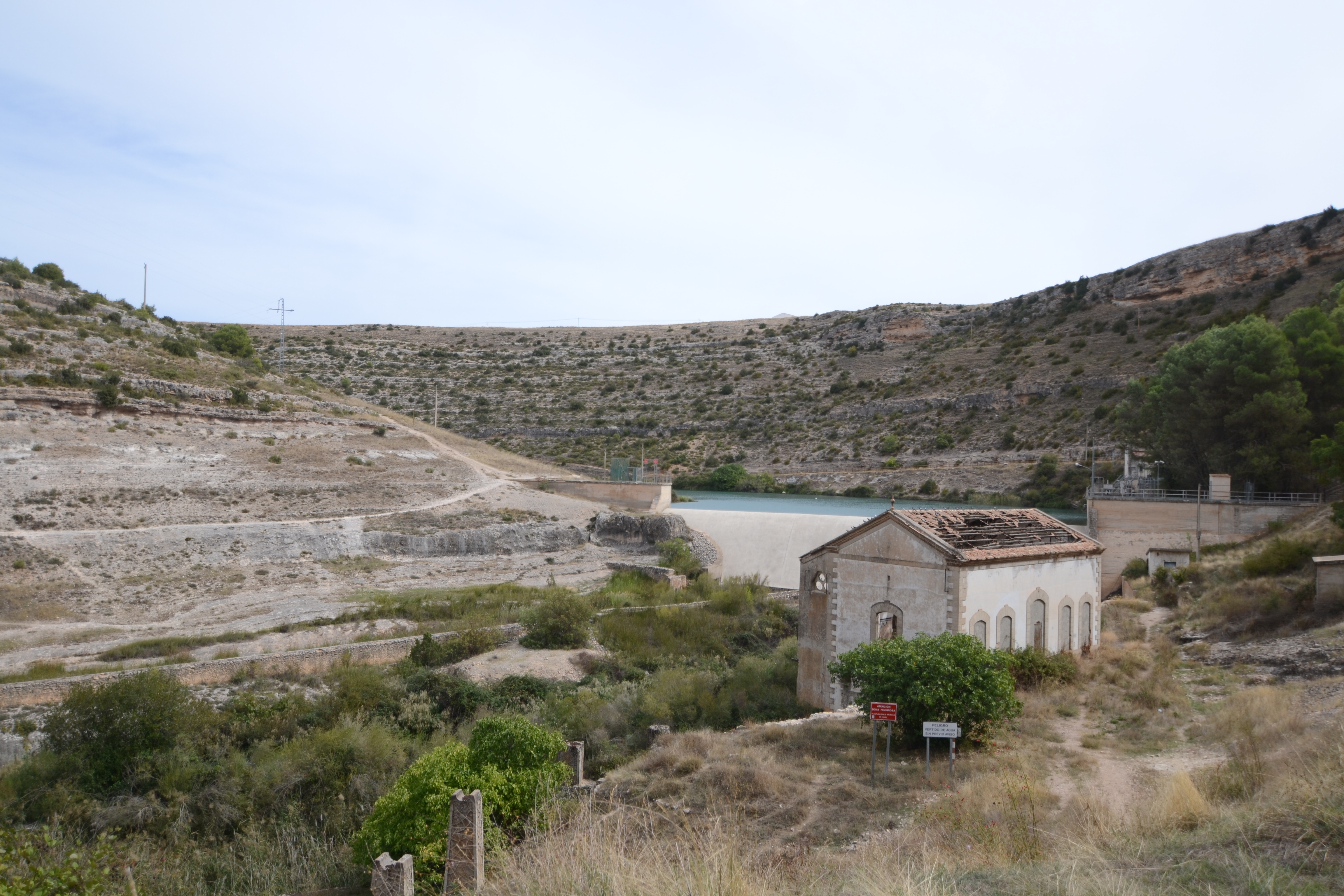
The path continues along the river's edge and reaches the Henchidero dam and the old installations of its hydroelectric power station. The dirt track becomes an asphalt path (and is once again has shared with traffic) as the route begins the ascent towards Alarcón. This path follows the meander on which Alarcón is situated. Passing the Tébar bridge (originally a medieval infrastructure but modified in later centuries), which offers access to the tower of Alarconcillos or the tower of Cañavete, we enter a pine forest and pass under one of the old entrance gates to the walled complex, the so-called Puerta del río or River Gate.
The stage ends as we complete the climb, next to a car park and the street leading down to the cemetery, but we recommend travellers take a stroll through the streets of Alarcón and discover the historical heritage of this town that still retains a medieval air.
Sites of interest
Puntos de interés
Culture
- Puerta del Campo
- Puerta del Bodegón
- Torre del Cañavete
- Torre de Armas
- Puerta del Calabozo
- Castillo de Alarcón
- Puerta del río
- Telégrafo óptico
- Monumento a Gascas
- Torre de los Alarconcillos
- Puerta de la Chinchilla
Hydrography
Infrastructure
Municipality
Hostel
Vegetation
Profile

MIDE (Method for the Information of Excursions)
 Harshness of natural environment
- 1. The environment is not risk-free
- 2. There are more than one risk factors
- 3. There are various risk factors
- 4. There are quite a lot of risk factors
- 5. There are many risk factors
 Guidance along the route
- 1. Well defined trails and crossings
- 2. There is a clearly marked trail and signage
- 3. Requires the identification of geographic features and cardinal points
- 4. Requires off-path navigation
- 5. The trail is interrupted by obstacles that have to be gone around
 Route difficulty
- 1. Walking on a flat surface
- 2. Trails with different types of path
- 3. Walking on stepped paths or irregular terrain
- 4. The use of hands or jumping over the terrain is necessary
- 5. The use of hands is required to progress
 Amount of effort needed
- 1. Up to 1 hour of continuous walking
- 2. Between 1 and 3 hours of continuous walking
- 3. Between 3 and 6 hours of continuous walking
- 4. Between 6 and 10 hours of actual walking
- 5. More than 10 hours of continuous walking
Highlights
Olmedilla de Alarcón
The La Mancha municipality of Olmedilla de Alarcón is located in the province of Cuenca, more specifically in the La Manchuela county, on the banks of the river Júcar, a few short kilometres from the Alarcón reservoir.
It takes its name from the characteristic vegetation of the area, the elm (ulmus), and its nickname was used to indicate that the village belonged to the jurisdiction of Alarcón. The remains of an Iberian necropolis have been found a few kilometres from the town centre. Artefacts like pottery and fibulae indicate the pre-Romanesque origin of the locality. However, it was not until the repopulation of the province of Cuenca, under the troops of King Alfonso VIII, and the conquest of Alarcón in 1184 that this town was consolidated, becoming part of the lordship of Alarcón.
The parish church of San Pedro and San Pablo, built at the beginning of the 18th century, stands out. It consists of a single nave and its interior features several frescoes with allegories of the Battle of Lepanto (1571). The old Romanesque baptismal font is on display in the Archaeological Museum of Cuenca. On the outside, there is a semicircular portico and a two-part belfry made of ashlar masonry.
In the town you can also visit the municipal park, which has an imposing entrance with several arches and the coat of arms of the town printed on the cobblestones, the fountain located in the street of the same name, the Plaza Mayor, where the Town Hall stands (a modern building with two floors and a balcony supported by stone columns) or the stone bridge over the Arroyo de la Hoz.
As a curiosity, this small Cuenca village is home to 3 photovoltaic parks, which together cover a surface area of 320 hectares and generate a power of more than 65 mw, equivalent to the amount of energy consumed by 35,000 people in a year. The first solar farm in the town was installed in 2015 and at that time was the largest in Europe but is today dwarfed by the other two parks in the municipality.
Local festivals are held in mid-August (between 13 and 19 August) the patron saint festivities dedicated to San Roque are held, and the El Niño festival dedicated to the baby Jesus (3rd Sunday in January).
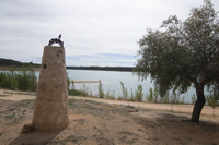
Gascas Monument
On the banks of the Alarcón reservoir, in the municipality of Olmedilla, there is a monument commemorating the disappeared village of Gascas de Alarcón. The monolith, made of stone, serves as a tribute to the memory of an old town in Cuenca, Gascas de Alarcón, which was buried under the waters of the river Júcar after the construction of the Alarcón reservoir dam.
The village of Gascas was founded during the period of the reconquest and repopulation of the province of Cuenca, under the reign of Alfonso VIII. A territory that was ceded to soldiers from Gascony, a county in the south-west of France in the hands of Alfonso VIII's wife, Eleanor of Plantagenet (daughter of Henry II of England and Eleanor of Aquitaine).
These settlers named Gascas in memory of their origin. They settled on the peninsula from the end of the 12th century, mainly dedicated to agriculture and irrigated farming, thanks to the waters of both the river Júcar and the Arroyo de Gascas, which is also currently submerged under the reservoir.
The construction of the reservoir meant that the village had to be abandoned before 1951, and today, in the summer months, when the water level of the reservoir falls, part of the walls and ruins become visible.
Every year, since the inauguration of the monument in 2010, a tribute is held in the municipality of Olmedilla de Alarcón in Cuenca, with the subsequent mass on the banks of the reservoir.
Multimedia


Downloads

GPS Downloads


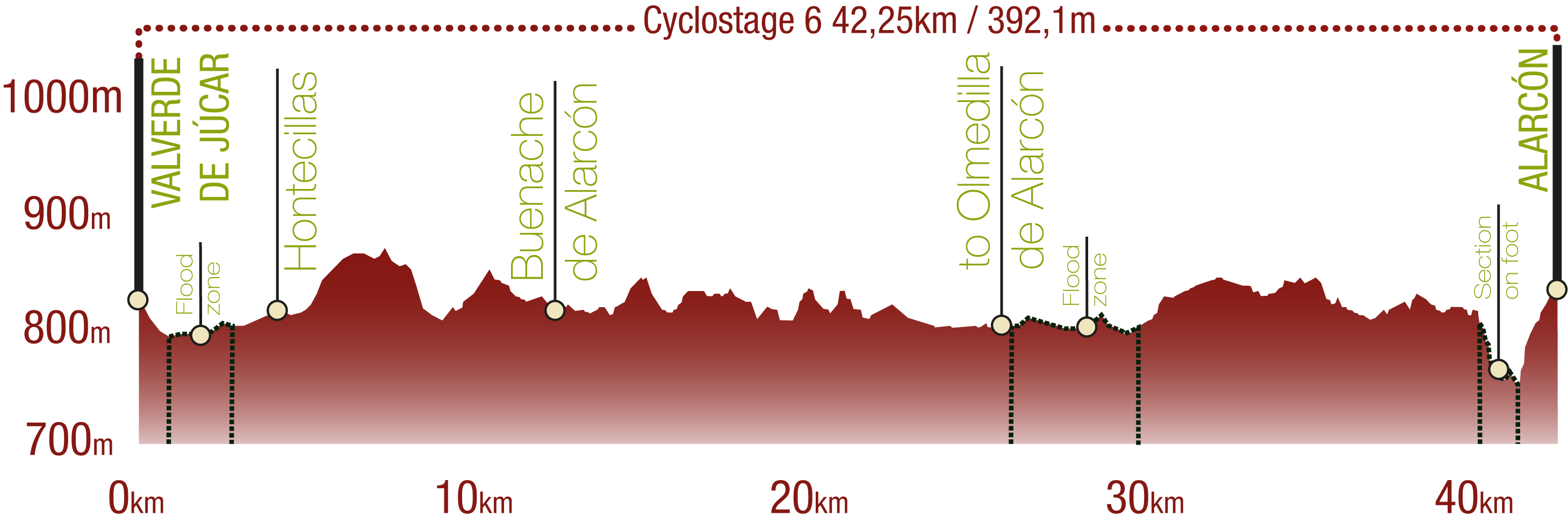
Cyclability
This Cyclostage corresponds to part of stage 10 and stage 11 of the Nature Trail
PROFILE
TYPE OF ROADS, PORTAGES & DIFFICULTY

TEST

SAFETY RECOMMENDATIONS
- The roads are mainly on tracks with access to farms and rural establishments, so there is a certain risk of being run over.
- There are two seasonal periods in which the Nature Trail is not passable if the waters of the Alarcón reservoir are very high. It is advisable to check this situation before setting off.
- Caution is advised at the junction of the CM-2100 and N-III roads.
- There is a walk of about 15 minutes along an uneven footpath with some risk of falls.
GENERAL RECOMMENDATIONS
- Find out about the technical aspects of the route and the weather on the day.
- Take care of the environment. Take care not to disturb animals or damage vegetation. Respect private areas.
- You must give priority to pedestrians and comply with general traffic rules.
- The environment in which you will be riding is open, free to move around and an area where many activities are carried out (sporting, forestry, livestock and agricultural activities). Always have an understanding, prudent, responsible and respectful attitude.